Northern Alberta
Northern Alberta | |
|---|---|
|
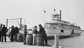
Left-right from top:Aurora borealis,Fort McMurrayandGrande Prairieskylines,Athabasca Riverpaddlewheeler | |
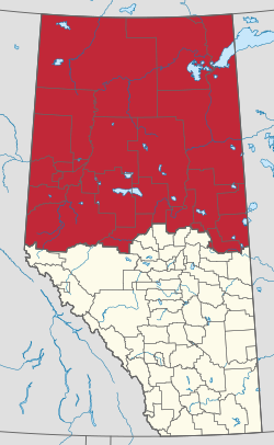
 Northern Alberta Development Council area | |
| Largest population centres | Fort McMurray Grande Prairie Cold Lake Whitecourt Peace River Slave Lake |
Northern Albertais ageographic regionlocated in theCanadian provinceofAlberta.
An informally defined cultural region, the boundaries of Northern Alberta are not fixed. Under some schemes, the region encompasses everything north of the centre of theCalgary–Edmonton Corridor,including most of the province's landmass as well as its capital,Edmonton.Other schemes place Edmonton and its surrounding farmland inCentral Alberta,limiting Northern Alberta to the northern half of the province, whereforestry,oil, and gasare the dominant industries.
Its primary industry isoil and gas,with large heavy oil reserves being exploited at theAthabasca oil sandsandWabasca areain the east of the region.Natural gasis extracted inPeace regionandChinchaga-Rainbowareas in the west, andforestryandloggingare also developed in theboreal forestsof this region. As of 2011, the region had a population of approximately 386,000.[1]
Geography
[edit]Various definitions exist of Northern Alberta's boundaries. The definition used by the Northern Alberta Development Council, an agency of the provincial government, includes the communities ofWhitecourt,Athabasca,Saddle Lake,St. Paul,andCold Lake,while excludingHinton,Edson,Mayerthorpe,andWestlock.This definition is also used by theUniversity of Albertato define eligibility for northern research grants.[2]
The region consists ofaspen parklandin the south, grading toboreal forestandmuskegin the north.
The southwest of the region is part of thePeace Country,an area that stretches into northeasternBritish Columbiaconsisting of fertileprairie,ranchland,and farmland along thePeace Riverand its tributaries.
Northern Alberta is crossed by thePeace Riverand theAthabasca River,both of which eventually convene to form theSlave Riverthat ultimately drains into theArctic OceanviaGreat Slave Lakeand theMackenzie Riverwithin theNorthwest Territories.Other major rivers areWapiti,Smoky,Hay,Chinchaga,Petitot Riversin the west,Wabasca Riverin the center andFirebagandClearwater Riverin the east.Alberta'stwo largest waterbodies,Lake AthabascaandLake Claireare located in thewetlandsof northeasternAlberta,forming thePeace-Athabasca Delta,that drains through theSlave Rivertowards theArctic Ocean.
TheCaribou Mountainsare an elevatedplateauin the relatively flat Albertan north which provide core habitat for an endangered woodlandcaribouherd. This area is conserved by theCaribou Mountains Wildland Park.The adjacentWood Buffalo National ParkisCanada'slargest protected area.
Other tourist attractions in Northern Alberta include theFort McMurrayHistorical Society-Heritage Park, HistoricDunvegan,Kimiwan Birdwalkand Interpretive Centre,Lesser Slave LakeBird Observatory in theLesser Slave Lake Provincial Park,Muskoseepi Park,Kakwa Wildland Provincial Park,Willmore Wilderness Parkand theOil SandsDiscovery Centre.[3]
Northern Alberta contains severaldiamondbearingdiatremesassociated withkimberlitefields, including theBuffalo Head HillsandBirch Mountains kimberlite fieldswhich in turn form theNorthern Alberta kimberlite province.
Fauna
[edit]Animals of Northern Alberta include theMackenzie Valley gray wolf(Canis lupus occidentalis),British Columbian red fox(Vulpes vulpes abietorum),fishers(Pekania pennanti),American black bear(Ursus americanus),northwestern moose(Alces alces andersoni),white-tailed deer(Odocoileus virginianus),wood bison(Bison bison athabascae),groundhogs(Marmota monax canadensis),northern coyotes(Canis latrans incolatus),wolverines(Gulo gulo), andmountain lions(Puma concolor). Multiple elusive and out-of-range animals have been reported in this region, including a singulargray fox(Urocyon cinereoargenteus) was recorded close toLake Athabasca,[4]and multiple vagrant birds includingnorthern cardinals(Cardinalis cardinalis),wandering tattlers(Tringa incana),[5]andnorthern wheatears(Oenanthe oenanthe).[5]Alberta also has reports of wild boars (Sus scrofa) coming into the province.
Infrastructure
[edit]Transportation
[edit]Highway 43andHighway 2pass through the southwest of the region, this being the end of theCANAMEXcorridor. Other important routes are theMackenzie HighwayandBicentennial Highwayin the northwest, theNorthern Woods and Water Routein the southeast andHighway 63in the east.[6]
Grande Prairie Airport,Peace River Airport,andFort McMurray Airportare regional air transportation hubs.
Health regions
[edit]Northern Alberta'shealth regionis controlled byAlberta Health Services.
Politics
[edit]On a provincial level, Northern Alberta is represented in theLegislative Assembly of AlbertabyMembers of the Legislative Assemblyelected in the ridings ofAthabasca-Redwater,Barrhead-Morinville-Westlock,Bonnyville-Cold Lake,Dunvegan-Central Peace,Fort McMurray-Conklin,Fort McMurray-Wood Buffalo,Grande Prairie Smoky,Grande Prairie Wapiti,Lac La Biche-St. Paul,Lesser Slave Lake,andPeace River.
Communities
[edit]See also
[edit]References
[edit]- ^"NADC Area Profile: An Economic Description of the Region"(PDF).Nadc.ca.May 2016.RetrievedFebruary 4,2022.
- ^"UofA Northern Research Awards".UAlberta North.RetrievedOctober 18,2019.
- ^Travel Alberta."Attractions in Alberta".Archived fromthe originalon 2009-03-03.Retrieved2007-01-06.
- ^"Recovery Strategy for the Grey Fox (Urocyon cinereoargenteus) in Canada"(PDF).Government of Canada. 2017.
- ^abScott, David (ed.)."Alberta Rare Bird Reports".University of Lethbridge Library.Retrieved2023-02-22.
- ^Alberta Motor Association."Northern Alberta - Road report".Retrieved2007-01-11.
External links
[edit]- NADC- Northern Alberta Development Council
- Travel Alberta- Alberta North
- Alberta Regions- Alberta Heritage
- DiscoverThePeaceCountry.com featuring Villages, Towns, Cities, Parks and Lakes of Northern Alberta


