
Odenwald
| Odenwald | |
|---|---|
 Overview of the Odenwald | |
| Highest point | |
| Peak | Katzenbuckel |
| Elevation | 626 m (2,054 ft) NHN |
| Coordinates | 49°28′15″N9°2′28″E/ 49.47083°N 9.04111°E |
| Dimensions | |
| Area | 2,500 km2(970 sq mi) |
| Geography | |
 Odenwald | |
| Country | Germany |
| Region | Hesse,Bavaria,Baden-Württemberg |
| Range coordinates | 49°35′N9°1′E/ 49.583°N 9.017°E |

TheOdenwald(German:[ˈoːdn̩valt]) is a low mountain range in theGermanstates ofHesse,BavariaandBaden-Württemberg.
Location
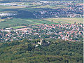
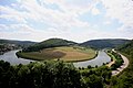
[edit]The Odenwald is located between theUpper Rhine Plainwith theBergstraßeand theHessisches Ried(the northeastern section of the Rhine rift) to the west, theMainand theBauland(a mostly unwooded area with good soils) to the east, theHanau-Seligenstadt Basin– a subbasin of the Upper Rhine Rift Valley in the Rhine-Main Lowlands – to the north and theKraichgauto the south. The part south of theNeckarvalley is sometimes called theKleiner Odenwald( "Little Odenwald" ).
The northern and western Odenwald belong to southern Hesse, with the south stretching intoBaden.In the northeast, a small part lies inLower Franconiain Bavaria.
Geology
[edit]

The Odenwald, along with other parts of the Central German Uplands, belongs to theVariscan,which more than 300 million years ago in theCarboniferousperiod ran through great parts ofEurope.The cause of thisorogenywas the collision ofAfrica’s and Europe's forerunner continents.
In theTriassic,about 200 million years ago, the land sank again, forming theGermanic Basinin which the metre-thick layers of red sandstone couldbuild up.These were later covered over with layers ofmuschelkalkfrom a broad inland sea, then followed by sediments from theLate Triassic(or Keuper). The South GermanCuestaLand thus formed.
When the land in the Odenwald wasupliftedagain about 180 million years ago, more than 100 m of the sedimentary layering, in parts, waserodedaway down to thebedrock,as can still be seen in the western Odenwald. The bedrock here is composed of a number of different rocks, among themgneiss,granite,diorite,gabbroin the Frankensteinpluton,and so on. In the eastern Odenwald, the red sandstone is all that is left of the sedimentary mixture. Farther east in the Bauland, the muschelkalk deposits still overlie theEarly Triassiclayers. Furthermore, in the south nearHeidelberg,there is stillZechsteinunder the Early Triassic deposits.
Roughly 50 to 60 million years ago,volcanoesformed along the great geologicalfaults.Still bearing witness to this time are theOtzberg,the Daumberg and the Katzenbuckel, all extinct volcanoes in the Odenwald. Furthermore, volcanism withacidicrocks has left a legacy ofrhyolitesnearDossenheim.
At roughly the same time, the Central European plate began to tear apart so that theUpper Rhine Riftdeveloped. Even as the Upper Rhine Rift valley still sinks today by just under a millimetre each year, the Odenwald, relatively to that, was uplifted to the height it has today. Along the faults, the small rivers Gersprenz and Weschnitz have, in part, carved their courses.
The Upper Rhine Rift is part of a fracture zone reaching from theMediterranean SeatoNorway.Right on the edge of the Odenwald, it is roughly 2 500 m deep, but has been filled in to its current height by river and sea sediment, for until about 20 million years ago, theNorth Seareached far inland, across theWetterauDepression into the Rhine Valley.
Geological maps
[edit]-
![Granite-Gneiss-Odenwald (Altherr, 1999)[1]](https://upload.wikimedia.org/wikipedia/commons/thumb/e/e8/Geologie_Odenwald_%28Altherr%29.jpg/115px-Geologie_Odenwald_%28Altherr%29.jpg) Granite-Gneiss-Odenwald (Altherr, 1999)[1]
Granite-Gneiss-Odenwald (Altherr, 1999)[1] -
![Granite-Gneiss-Odenwald (Stein, 2001)[1]](https://upload.wikimedia.org/wikipedia/commons/thumb/4/43/Geolog._Karte_%28Stein%29_Odw7.jpg/78px-Geolog._Karte_%28Stein%29_Odw7.jpg) Granite-Gneiss-Odenwald (Stein, 2001)[1]
Granite-Gneiss-Odenwald (Stein, 2001)[1] -
![Granite-Gneiss- and Redsandstone-Odenwald (Stein, 2001 + Weber, Geo-Naturpark)[2]](https://upload.wikimedia.org/wikipedia/commons/thumb/4/4c/GeolKarte_Geopark.jpg/124px-GeolKarte_Geopark.jpg) Granite-Gneiss- and Redsandstone-Odenwald (Stein, 2001 + Weber,Geo-Naturpark)[2]
Granite-Gneiss- and Redsandstone-Odenwald (Stein, 2001 + Weber,Geo-Naturpark)[2] -
![Geological profile (from left): Rheinplane, Granite-Odenwald, Gneiss-Odenwald, Redsandstone-Odenwald (Geo-Naturpark)[2]](https://upload.wikimedia.org/wikipedia/commons/thumb/c/c2/Profil_Geologie_Odenwald.jpg/250px-Profil_Geologie_Odenwald.jpg) Geological profile (from left): Rheinplane, Granite-Odenwald, Gneiss-Odenwald, Redsandstone-Odenwald (Geo-Naturpark)[2]
Geological profile (from left): Rheinplane, Granite-Odenwald, Gneiss-Odenwald, Redsandstone-Odenwald (Geo-Naturpark)[2]
![Granite-Gneiss-Odenwald (Altherr, 1999)[1]](/translate/en.wikipedia.org?u=https%3A%2F%2Fen.wikipedia.org%2Fwiki%2FFile%3AGeologie_Odenwald_%28Altherr%29.jpg&t=hv)
![Granite-Gneiss-Odenwald (Stein, 2001)[1]](/translate/en.wikipedia.org?u=https%3A%2F%2Fen.wikipedia.org%2Fwiki%2FFile%3AGeolog._Karte_%28Stein%29_Odw7.jpg&t=hv)
![Granite-Gneiss- and Redsandstone-Odenwald (Stein, 2001 + Weber, Geo-Naturpark)[2]](/translate/en.wikipedia.org?u=https%3A%2F%2Fen.wikipedia.org%2Fwiki%2FFile%3AGeolKarte_Geopark.jpg&t=hv)
![Geological profile (from left): Rheinplane, Granite-Odenwald, Gneiss-Odenwald, Redsandstone-Odenwald (Geo-Naturpark)[2]](/translate/en.wikipedia.org?u=https%3A%2F%2Fen.wikipedia.org%2Fwiki%2FFile%3AProfil_Geologie_Odenwald.jpg&t=hv)
History
[edit]About 2500 BC, there is evidence that theLinear Pottery culturesettled along the northern (Gersprenz) and southern (Neckar valley) edges of the Odenwald. About 400 BC,Celts(Gauls) settled throughout southern Germany. Almost all of the Odenwald was covered then withvirgin forest,and the outer edges were not settled.Germanic peoplesdrove the Celts westwards across the Rhine to what is nowFrance.

About AD 100, the older Odenwald line of theNeckar-Odenwald Limeswas built underRomanEmperorTrajan(98-117). This stretch of the Empire's border ran from Fort Wimpfen in the Valley (Kastell Wimpfen im Tal) northwards by way of the Forts of Neckarburken, the lesser forts of Trienz and Robern nearFahrenbach,Fort Oberscheidental, Fort Schloßau, Fort Hesselbach, Fort Würzberg, Fort Eulbach, Fort Hainhaus and Fort Hesselbach to Fort Wörth on theMain.Parts of the Odenwald now lay in Roman-ruledGermania Superior.
About 159, the Limes was shifted about 30 kilometres (19 miles) eastwards to theMiltenberg–Walldürn–Buchen-Osterburkenline. In 260, Roman hegemony fell. TheAlamanniwere also thrusting into the Odenwald and settling the land between the Main and Neckar, after whom came theFranks.In the 5th century, the Franks, underClovis I,divided the land up into districts.
In the 7th and 8th centuries cameChristianizationbyIrish-ScottishandAnglo-Saxonmonks (Pirmin,Boniface). On the muschelkalk lands of today's Bauland, which favouredagriculture,a broad mesh of settlements arose. The parts of the Odenwald farther in from the rivers, though, with their scantNew Red Sandstonesoils remained uninhabited. FourBenedictinemonasteries were assigned the job of opening the empty woods up by the central Frankish power (Carolingian),Lorsch Abbeyfrom the west, Fulda Monastery from the east and Mosbach Monastery from the south. Amorbach Monastery had the greatest importance for ecclesiastical, cultural and economic development in the eastern Odenwald.
In the 9th century in the southeastern Odenwald near the now more thickly settled Bauland, settlements were established. The muschelkalk-new red sandstone mineral boundary was crossed.
Name
[edit]This sectionneeds additional citations forverification.(May 2024) |
The following are some theories about the origin of the nameOdenwald:
- Some have claimed that the toponym comes fromOdins Wald(Odin’s Woods). The main problem here is that the godWodanaz(known in Norse asOdin) was worshipped in southern Germany under the nameWotan(inOld High GermanUuodan;compareMerseburg Incantations).
- A further theory holds that there is a link between the name Odenwald and theRomanadministrative unit Civitas Auderiensium, which among other things included the range's northern reaches and might have been named after a tribe called theAuderienses.
- There could be some kinship with the wordöde,not in the currently understood meaning in German ofdesert,but rather in the meaningthinly settled.
- Einhard,the biographer ofCharlemagneused the termOdanwald.Therefore, the renowned historian Karl Christ establishes a connection to the Old High German (ahd.) expressionodan(=to enfeoff) and presumes, that theOdenwaldwas a hunting ground, which the King of the Franks Dagobert I. enfeoffed in 628 the Bishopric of Worms.[3]
- An eminent geographer of the 16th century, Sebastian Münster, proposed a tribal chief as the name giver (Odtonwald,821, =Odo's Woods). However, it is not proven whether there actually was a count or duke calledOdo(Otto). Finally, Münster's researches do not lead to any result.[3]
Linguists who research phonetic changes and the sound shifts reject theories no. 1 to 3 and prefer 4 or 5; some historians favor no. 2.
Legends and mythology
[edit]The numerous Odenwald folk legends are mostly connected with historic geographic sites (castle, town, rock, road and so on) They relate:
- mysterious actions and appearances of ghosts in a castle (for example the twoBergstraße-ruinsAuerbach - castleandWindeck) or in a nightscape respectively in a cottage: TheHöhmannnear Bensheim, theWhite Ladyof Mossau, theSchlurcherclose by Erbach, theMan without headnear Heppenheim, theGoast-nunsof monasterySteinbach.
- the stories of knights and their ladies: Konrad and Ann-Els von Tannenberg, Edelmut von Ehrenberg and Minna von Horneck at theMinneburg,Georg von Frankenstein and Annemariechen, Hans von Rodenstein and Maria von Hochberg.
- the apparitions of the devil:Teufelspfad(pathway of the devil) to theFelsberg,Teufelsstein(rock of the devil) in Gorxheimertal,Opferstein(altar stone) on the top of theJuhöhe.
- or the apparitions of a witch: for example in the shape of a pig in Bensheim
In some stories the local aspect firstly is connected with monsters (knight Georg fights against the man-eatinglindwormnearFrankenstein-castle) and creatures of nature with magic potency (awater spiritchanged into a fox near Niedernhausen, themerwomanin theMeerwieseof Waldürn).
Secondly the local legend is connected with the genre of the historic saga: a historic person or an original is portrayed anecdotally (the count of Erbach and Luther, resp. theRaubacher Joggel,landgrave Ludwig VIII: of Hesse-Darmstadt, robberHölzerlips).

Thirdly a local tale explains anetiologicalor original myth (aetiological saga). For example, there is explained:
- why a name is given: manyWildweibchensteine(Wild Woman-Rocks) in the Odenwald,Teufelsstein(stone of the devil),Teufelspfad(path of the devil),Opfersteine(altar stone) andHundsköpfe(dogheads) on top of theJuhöhe,Hölzerlips-stone,Schimmeldewoogfor the village Schönmattenwag (→Folk etymology) or the phrase “hinnerum wie die Fraa vun Bensem”,
- why a natural phenomena, for example a typical landscape, was formed: the saga creates a mythic history for the places of thefelsenmeerand theHohensteinnear Reichenbach (because giants stoned each other) or theHerrgottsfelsen(Godrock) near Darmstadt (act of revenge by the devil for finessing),
- why a castle (Minneburg) was built at a special place (Minnebergat the Neckar) and was so named hereafter,
- why a mysterious stone carving was inset in a castle-wall: figure of a dog at the portal of theMinneburgnear Neckargerach, theBleckerat the town gate of Buchen, theBreileckerabove the door of Breuberg-castle.
Beside these legends there are two famous and well-known Odenwaldsagas:
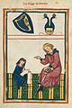
In theNibelungenlied(see alsoNibelung) the dragon slayerSiegfried,on a hunting trip (instead of a failed campaign) leading from theBurgundiancity ofWormsinto the Odenwald, is murdered byHagen of Tronje.Since no exact spot for this deed has been handed down, countless communities, especially in the Hessian Odenwald are squabbling over the right to call themselves “Siegfried’s Murder Site”, for example a spring near Gras-Ellenbach (Siegfriedsbrunnen), Mossautal-HüttenthalLindelbrunnen) or Heppenheim (Siegfriedbrunnen).
The ruins ofRodenstein(below-mentioned) andSchnellertsnearFränkisch-Crumbachare the setting of an Odenwald ghost story: during the night the knightRodenstein(theRodensteiner) flies with a berserker-cornet through the air to prophesy the beginning of a war (Wild Huntmotif).
-
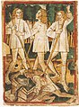
 "Siegfried's Death" (Julius Schnorr von Carolsfeld,1847): Hagen murdered Siegfried by a spring in the Odenwald.
 -
 Picture of Siegfrieds assassination in the Nibelungenlied-manuscript k (1480–90)
 -
 Siegfriedbrunnenby Wilhelm Trübner. In the legend there is no exact description in respect of the hunting trip.
 -
 Rodenstein Castleis the scene of theRodensteinerghost legend (19th-century picture).


Topography
[edit]Mountains
[edit]Over 600 m
[edit]- Katzenbuckel(626 m; lookout tower),Neckar-Odenwald-Kreis,Baden-Württemberg
- Neunkircher Höhe(605 m;Kaiser Tower),Bergstraße district,Hesse
-
 TheCrystal Teaching Patharound theKatzenbuckelstarts near the old volcanic quarry (below-mentioned)
 -
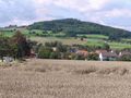
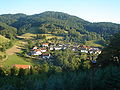
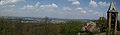
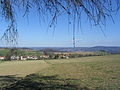
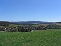 Neutsch with a view to Neunkirchen and theNeunkircher Höhe
 -
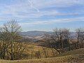
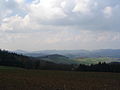
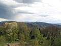
 View fromWeschnitz- Valley to the mountainsHardberg(with transmitter),Götzenstein,Kisselbusch(from left)
 -
 Weschnitz- Valley with a view toTromm-mountain range


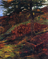
Over 450 m
[edit]- Hardberg(593 m), Bergstraße district, Hesse
- Stiefelhöhe(584 m), Hesse/Baden-Württemberg border
- Tromm(577 m; lookout tower), Bergstraße district, Hesse
- Krehberg(576 m; with Krehberg transmitter), Bergstraße district, Hesse
- Königstuhl(567.8 m;observatory,funicular railway),Heidelberg,Baden-Württemberg
- Krähberg(555 m),Odenwaldkreis,Hesse
- Kinzert (554 m),Neckar-Odenwald-Kreis,Baden-Württemberg
- Weißer Stein(550 m; lookout tower),Rhein-Neckar-Kreis,Baden-Württemberg
- Hohe Warte (548 m), Rhein-Neckar-Kreis, Baden-Württemberg
- Spessartskopf(547 m), Bergstraße district, Hesse
- Falkenberg (546 m), Odenwaldkreis, Hesse
- Waldskopf(538 m),Gorxheimertal-Trösel, Bergstraße district, Hesse
- Das Buch (535.30 m; near Lindenfels), Bergstraße district, Hesse
- Wagenberg (535 m), Bergstraße district, Hesse
- Eichelberg (526 m; lookout tower), Rhein-Neckar-Kreis, Baden-Württemberg
- Götzenstein(522 m), Bergstraße district, Hesse
- Melibokus(„Malschen “) (517.40 m), Bergstraße district, Hesse
- Morsberg(517 m), Odenwaldkreis, Hesse
- Felsberg(514 m; with Felsenmeer), Bergstraße district, Hesse
- Knodener Kopf (511.20 m), Bergstraße district, Hesse
- Wannenberg (482 m),Miltenberg district,Bavaria
- Daumberg(462 m), Gorxheimertal-Trösel, Bergstraße district, Hesse
-
 Overlooking theKrehberg(view from Lindenfels)
 -
 The Waldskopf in the Gorxheim valley
 -
 TheMelibokusnearZwingenberg
 -
 With a view from theLauter- Valley (Hohenstein) to theMelibokus(right) and theAuerbachCastle (background, in the middle)
 -
 TheGesprenz-Valley gneiss-sandstone-mountain range:Böllsteiner Höheon the left,Morsbergin the middle
 -
 TheFelsberg(with transmitter, view from theLauter-Valley),Auerbach-Castle andMelibokuson the left
 -
 The Daumberg in the Gorxheim valley
 -
 TheWeschnitz-Valley withHirschkopf-Juhöhe-mountain range (view from the Tromm)


Over 300 m
[edit]- Heiligenberg(445 m), Heidelberg, Baden-Württemberg
- Knorz (404 m; near Lautern), Bergstraße district, Hesse
- Otzberg (367 m; withOtzberg Castle),Darmstadt-Dieburg,Hesse
- Auerberg (339.70 m; with Schloss Auerbach), Bergstraße district, Hesse
- Breuberg (306 m; with Breuberg Castle), Odenwaldkreis, Hesse
Bodies of water
[edit]Flowing water
[edit]Countless streams rise in the Odenwald, the longest of which are the following:
- Weschnitz (60 km), tributary to the Rhine
- Mümling (50 km), tributary to the Main
- Gersprenz (47 km), tributary to the Main
- Lauter (43 km), tributary to the Rhine
- Erf (40 km), tributary to the Main
- Elz (Elzbach) (34 km), tributary to the Neckar
- Finkenbach (20.5 km), joins the Ulfenbach in Hirschhorn, runs to the Laxbach, tributary to the Neckar
- Ulfenbach (19.1 km), joins the Finkenbach in Hirschhorn, runs to the Laxbach, tributary to the Neckar
- Grundelbach, (10 km), flows from Trösel to Weinheim
- Modau (42 km), tributary to the Rhine
- Mud (24 km), tributary to the Main
- Steinach (22 km), tributary to the Neckar


Standing water
[edit]There are a few bodies of standing water in the Odenwald, among which are the following:
- the MarbachReservoir
- the Eutersee
Political divisions
[edit]Districts (with district seats)
[edit]- Bergstraße district(Heppenheim)
- Darmstadt-Dieburg(Dieburg,administration inDarmstadt-Kranichstein)
- Main-Tauber-Kreis(Tauberbischofsheim)
- Miltenberg district(Miltenberg)
- Neckar-Odenwald-Kreis(Mosbach)
- Odenwaldkreis(Erbach)
- Rhein-Neckar-Kreis(Heidelberg)
District-free cities
[edit]
International relations
[edit]Twin towns – Sister cities
[edit]Odenwald istwinnedwith:
Transport and tourism
[edit]The Odenwald is known as a leisure destination easily accessible from the urban areas ofMannheimandFrankfurt.It is known for its clean thin air and was once known for its health sanitariums. There are many marked hiking paths through the rural areas. Wildblueberries,strawberriesandmushroomsare to be found in the forests.
Roads
[edit]The planned extension to theOdenwaldautobahn,that is, theA 45(Dortmund–Aschaffenburg), was never realized. Nevertheless, all theseBundesstraßenrun through the Odenwald:
- B 27:Mosbach-Buchen-Tauberbischofsheim
- B 38:Reinheim-Groß-Bieberau-Brensbach-Reichelsheim-Fürth-Mörlenbach-Birkenau-Weinheim
- B 45:Groß-Umstadt-Höchst-Bad König-Michelstadt-Erbach-Beerfelden-Eberbach
- B 47:Bensheim-Lindenfels-Reichelsheim-Michelstadt-Amorbach
- B 426:Darmstadt-Mühltal-Ober-Ramstadt-Reinheim-Otzberg-Groß-Umstadt-Höchst-Breuberg-Obernburg
- B 460:Heppenheim-Fürth-Mossautal- Hüttenthal
Furthermore, theNibelungenstraßeand theSiegfriedstraßerun through the Odenwald, partly along the roads listed above.
Railways
[edit]
- Odenwald RailwayfromDarmstadtorHanauby way ofGroß-Umstadt WiebelsbachtoEberbach,opened in 1882, since December 2005 run with modernItinotrains.
- Weschnitz Valley RailwayfromWeinheimtoFürth,opened in 1895.
- Überwald RailwayfromMörlenbachby way ofWald-Michelbachto Wahlen, opened in 1901, abandoned in 1996.
- Hetzbach–Beerfelden linefrom Hetzbach toBeerfelden,opened in 1904, abandoned in 1954.
- Mosbach–Mudau line(locally known as theEntenmörder– “Duck Murderer” ) fromMosbachtoMudau,former 1,000 mm (3 ft 3 in)narrow-gauge railway,opened in 1905, abandoned in 1973, since 1980 right-of-way has been converted into a cycling path.
- Neckar Valley RailwayfromHeidelbergby way ofEberbachand Mosbach toBad Friedrichshall-Jagstfeld,opened in 1879.
- Neckarelz–Osterburken line,opened in 1866 as part of theBaden Odenwaldbahn
- Madonnenland RailwayfromSeckachtoMiltenberg.
- Gersprenz Valley RailwayfromReinheimtoReichelsheim,opened in 1887 and abandoned by 1963.
Special day trips
[edit]
- In Hainstadt, Hesse (a constituent community ofBreuberg) in the Mümling valley is aquarrywhich has been turned into aclimbingfacility by theOdenwälder Kletterfreunde('Odenwald Climbing Friends'). There is also a climbing path secured by wire cables. The Odenwald Climbing Friends take care of the paths. The quarry also lies in the DAV's (Deutsche Alpenverein e. V.– a mountain climbing club)DarmstadtSection feeder area.
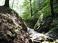
- Beneath the 514 m-high Felsberg and north ofLautertal-Reichenbach is found aFelsenmeer– literally 'cliff sea' – consisting of many weathered stones strewn about the ground which have fallen down from the cliff after having come loose from erosion. TheRomansused it as a stone quarry.
- In Eberstadt, a constituent community ofBuchen,one of southern Germany's most importantdripstone caveswas discovered in 1971. It is open to the public.
- Around the Katzenbuckel runs theKristall-Lehrpfad('Crystal Teaching Path'), which graphically shows the volcanic development in the Odenwald.
- From Höchst im Odenwald snakes the Obrunnschlucht (gorge) as a romantic fairytale path towards Rimhorn with many model buildings (palaces, castles and mills) along the valley.
- The Odenwald is threaded with a network of more than 10,000 km (6,214 miles) of hiking trails.
- Because the roads have so many bends, the Odenwald is a popular outing destination for motorcyclists.
- Every year one of the greatest Halloween events in Germany is organized on theFrankenstein Castle(see above). The same name suggests a connection withMary Shelleysfamous filmed novelFrankenstein or The Modern Prometheus.The horror scenery and the comedians dressed up as ghosts and witches spook the huge audience.
- Walking and climbing through theMargarethenschlucht(Neckargerach) or theWolfsschlucht(Wolf's Glen) nearZwingenberg castle(Zwingenberg/Neckar)
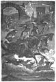
- Zwingenberg Castle(see above) is the place of an annual castle festival.Carl Maria von Webersromantic operaDer Freischütz(translated asThe MarksmanorThe Freeshooter) is performed at the entrance of the gorgeWolfsschlucht.The plot is based on a German folk legend which the composer discovered in theGespensterbuch('Book of Ghosts') during his sojourn in Neuburg Abbey nearHeidelbergin 1810. It is believed, that he also was inspired by the Wolf's Glen in aNeckartributary valley, but there are many places in Germany with the same name. Anyway. In act 2 the protagonist Max meets the diabolic Caspar in the supernatural creepy opera sceneWolfsschluchtto become the best shooter with the assistance of magic power. Now a risky action starts.

- For half a week early July theHeppenheimer(see above) Street theatre namedGassensensationenoccupies several places und corners of the old town with presentations for children and adults. The outdoor performances include very popular loud and simple genres with music, dance, mime, circus arts and slapstick, but also sensitive theatre plays or songs in discrete spaces.
- The granite rocks of theJuhöhenear Heppenheim inspired people to imagine fairy tales. They told, that the holes were offering cups for the devil. Stones nearby got chapped, when he sharpened his claws. According to a local version of theRodensteinerlegend theWild Huntercrossing theJuhöhelost his cry of hounds: They crashed and where rammed in the ground. Even today the petrified dogheads are on view at the top of the hill. So the rocks are calledHundsköpfe.Flat ironis the name of another granite formation near theJuhöhe.A long time ago Giant-ladies made use of it to set their Sunday dresses in order.
-
-
 Hohensteinnear Reichenbach (Baryte-quartz-cliff)
 -
 Borsteinnear Reichenbach (Baryte-quartz-cliff)
 -
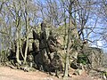
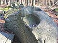
 Giant tortoise gneiss rocks (Böllstein)
 -
 Granite rocks (Tromm)
 -
 Reichenbach-Felsenmeer:The giant column (Riesensäule) is a workpiece of Roman stonemasons.
 -
 Granite rocksWildfrauhaus(Fischbachtal)
 -
 Zwingenberg (Neckar) gorge:Wolfsschlucht
 -
 When Caspar und Max begin with casting the magic bullets in theWolf’s GlentheWild Huntappears in the air with demoniacal noise.
 -
 The rocks at theJuhöheare supposed to be the petrified dogheads of theRodensteinercry of hounds
 -
 It is said, that the holes of theOpfersteinewere offering cups for the devil.
 -
 People of theKreiswaldnear theJuhöhetold, that a long time ago the granite formation was the flat iron of Giant-ladies


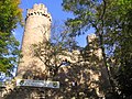
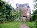
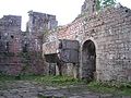
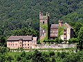
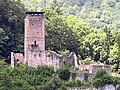
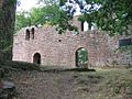
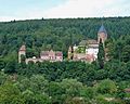
Castles
[edit]The Odenwald is home to many historic castles and palatial residences. In times past the fortresses on the top of the Odenwald mountains controlled Bergstraße and the Weschnitz-, the Gersprenz-, the Mümling- and the Neckar-Valley.
-
 FrankensteinnearDarmstadt/Upper Rhine Rift valley
 -
-
 The ruins ofTannenbergnear Seeheim (Seeheim-Jugenheim)
 -
 HeiligenbergCastle near Jugenheim (Seeheim-Jugenheim)
 -
 AlsbachCastle, view fromMelibokus(Alsbach-Hähnlein)
 -
 The ruins ofAuerbachCastle nearBensheim
 -
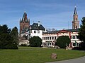
 Park and mansionFürstenlagernear Bensheim-Auerbach
 -
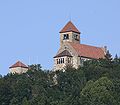
 SchönbergCastle (Bensheim-Schönberg)
 -
 Bergstaße:Starkenburg(view from Maiberg,Heppenheim)
 -
 StarkenburgwithSchlossberg(Heppenheim)
 -
 WeinheimCastle
 -
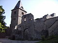
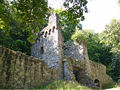
 The ruins ofWindeck(Weinheim)
 -
 WachenburgnearWeinheim(Two-Castles-Town)
 -
 Wachenburg(view fromHirschkopf-tower),Weißer Stein (lookout tower) in the background
 -
 StrahlenburgnearSchriesheim
 -
 The ruins ofSchauenburginDossenheim
 -
 BirkenauCastle near Weinheim
 -
 The ruins ofLindenfelsCastle,Bürgerturm(tower)
 -
 View fromWeschnitztalto Lindenfels (left), in the background right of centre:ReichenbergCastle, left picture margin:Neunkircher Höhe
 -
 The ruins ofRodensteinnearFränkisch-Crumbachare the setting of a ghost story:Rodensteinerflies with a berserker-cornet in the night through the air to prophesy the start of a war (see above).
 -
 ReichenbergCastle, entrance, nearReichelsheim
 -
 Gersprenz-Valley with Reichenberg
 -
 LichtenbergCastle (Fischbachtal)
 -
 Neunkircher Höhewith a view toLichtenbergCastle (left) and theReinheimer Bucht:Otzbergto the right of centre
 -
 Castle Grounds in Lichtenberg in Odenwald,Wilhelm Trübner,1900. Colección Carmen Thyssen Bornemisza.
 -
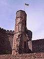
 extinct volcanoOtzbergand the old fortVeste Otzbergwith the white tower
 -
 ErbachCastle
 -
 FürstenauCastle (nearMichelstadt) with decorative gateway arch
 -
 Old Castle inBad König
 -
 BurgBreubergnear Höchst in the summer of 2006
 -
 BreubergCastle, keep (Bergfried) and main gate
 -
 The ruins ofWildenberg(Kirchzell) from the High Middle Ages, built in the Staufer era, whereWolfram von Eschenbachis said to have written parts of hisParzival.
 -
 Portrait of the medieval poetWolfram von Eschenbachfrom the Codex Manesse
 -
 Fireplace in the great hall. In WolframsParzivalthe author indirectly compares the gigantic fireplace in theGrail Castlewith that ofWildenberg:“so groziu fiwer sit noch e sach niemen hie ze Wildenberc” (line 230,12-13)
 -
 The ruins ofFreiensteinnearBeerfelden
 -
 WaldleiningenCastle in the British-style (near Mudau)
 -

-
 NeckarsteinachwithMittelburg(left) andVorderburg(in the middle)
 -
 Neckarsteinach:Vorderburg
 -
 Neckarsteinach:Mittelburg
 -
 Neckarsteinach:Hinterburg
 -
 Neckarsteinach:The ruins ofSchwalbennest
 -
 The medieval feudal lord and poet (minnesinger)Bligger von Steinach(Portrait from the Codex Manesse) resided in Steinach (Neckarsteinach)
 -
 Dilsbergwith mountain fort
 -
 Tower and wall of Dilsberg nearNeckarsteinach
 -
 Hirschhorn with Hirschhorn Castle
 -
 The ruins ofEberbachCastle
 -
 Zwingenberg Castle(also called theZwingenburg) (Zwingenberg/Neckar)


Music
[edit]Songs have been written about the Odenwald:
- Es steht ein Baum im Odenwald( “There Stands a Tree in the Odenwald” )
- Tief im Odenwald( “Deep in the Odenwald” )
- Der Bauer aus dem Odenwald( “The Farmer from the Odenwald” )[5]
See also
[edit]- Hessian dialects
- Historical territorial allegiances:Electorate of the Palatinate|Archbishopric of Mainz|Landgraviate of Hesse|Grand Duchy of Hesse|People's State of Hesse|Baden
References
[edit]- ^ab"Institut für Geographie: AKN - Mitarbeiter Jens-Philipp Keil".Archived fromthe originalon 2012-12-11.Retrieved2012-05-15.
- ^ab"Geo-Naturpark Bergstraße Odenwald".Archived fromthe originalon 2012-07-31.Retrieved2012-05-15.
- ^abMorneweg, Karl: Offizieller Führer des Odenwald-Klubs durch den Odenwald und die Bergstrasse. Ravenstein Frankfurt a.M. 1926, S.33.
- ^Falkirk Twinning AssociationArchivedMarch 23, 2012, at theWayback Machine,www.falkirktwinning.org Retrieved 2011-05-07
- ^text and melodyArchived2007-09-28 at theWayback Machineon the webpage of the Catholic Student Association Markomannia Münster in theKV.
Further reading
[edit]Monographs and anthologies
[edit]- Marco Lichtenberger:Saurier aus dem Odenwald.Jens Seeling Verlag. Frankfurt 2007.ISBN3-938973-04-8
- Winfried Wackerfuss (publisher):Zu Kultur und Geschichte des Odenwaldes.2. unveränderte Auflage 1982. Breuberg-Bund, Breuberg-Neustadt 1982.ISBN3-922903-01-0
- Otmar A. Geiger:Sagenhafter Odenwald. Ein Führer durch das Reich der Nibelungen zwischen Worms und Würzburg.Schimper, Schwetzingen 2000.ISBN3-87742-152-0
- Georg Bungenstab (publisher):Wälder im Odenwald - Wald für die Odenwälder. Dokumente aus 150 Jahren Eberbacher Forstgeschichte.Staatliches Forstamt Eberbach, Eberbach 1999, 288 S.
- Heinz Bischof:Odenwald.3., überarbeitete Auflage. Goldstadtverlag, Pforzheim 2004.ISBN3-89550-313-4
- Thomas Biller/Achim Wendt:Burgen und Schlösser im Odenwald. Ein Führer zu Geschichte und Architektur.Schnell & Steiner, Regensburg 2005.ISBN3-7954-1711-2
- Andreas Stieglitz:Wandern im Odenwald und an der Bergstraße.Aus der Reihe DuMont aktiv. DuMont Reiseverlag, Ostfildern 2005.ISBN3-7701-5015-5.
- Seipel, Herbert Stephan:Faszination Odenwald. Eine Bilderreise zur Kulturgeschichte des Odenwaldes.Verlag Regionalkultur, Ubstadt-Weiher 2004.ISBN978-3-89735-140-0
- Keller, Dieter/Keller, Uwe/Türk, Rainer:Der Odenwald zwischen Himmel und Erde.Verlag Regionalkultur, Ubstadt-Weiher 2003.ISBN978-3-89735-187-5
Periodicals
[edit]- Breuberg-Bund (publisher):Beiträge zur Erforschung des Odenwaldes und seiner Randlandschaften.Breuberg-Bund, Breuberg-Neustadt 1977 ff.
- Breuberg-Bund (publisher):Der Odenwald.Vierteljahreszeitschrift des Breuberg-Bundes mit Beiträgen zur Geschichte, Volkskunde, Kunstgeschichte und Geographie des Odenwaldes und seiner Randlandschaften. Breuberg-Bund, Breuberg-Neustadt 1953 ff.
- Kreisarchiv des Odenwaldkreises (publisher):Gelurt. Odenwälder Jahrbuch für Kultur und Geschichte.Odenwaldkreis, Erbach 1994 ff.
- Arbeitsgemeinschaft der Geschichts- und Heimatvereine im Kreis Bergstrasse (publisher):Geschichtsblätter Kreis Bergstraße.Laurissa, Lorsch 1971 ff.
The Odenwald in Literature
[edit]- Adolf Schmitthenner:Das deutsche Herz.3. Auflage. Stadt Hirschhorn, Hirschhorn, 1999.ISBN3-927409-00-6(first edition 1927)
- Werner Bergengrün:Das Buch Rodenstein.3. Auflage. Insel, Frankfurt am Main 2002.ISBN3-458-33493-9(first edition 1908)
- Adam Karrillon: Michael Hely. Reprint der 2. Auflage (Grote'sche Verlagsbuchhandlung, Berlin 1904) im Verlag Gustav Aderhold, Pfungstadt 1979.
- Georg Schäfer: Die Falschmünzer im Weschnitztal oder Die silbernen Glocken von Mörlenbach. Reprint der Ausgabe von 1896 im Verlag Herbert A. Kammer Rimbach.
External links
[edit]- Odenwald – Official page of Odenwald-Regional-Gesellschaft (OREG)(in German)
- UNESCO Geo-Park – Official page of Geo-Naturpark Bergstraße-Odenwald(in German)
- Odenwaldklub – Official page of Odenwaldklub(in German)
- Regionalentwicklung Odenwald – Official page of Interessengemeinschaft Odenwald e.V. (IGO)(in German)

| International | |
|---|---|
| National | |