
Orjen
This articleneeds additional citations forverification.(November 2023) |
| Orjen | |
|---|---|
| Орјен | |
 View of Orjen with peaksVeliki kabao(right) andVučji zub(left) | |
| Highest point | |
| Elevation | 1,895 m (6,217 ft) |
| Coordinates | 42°34′08″N18°32′56″E/ 42.56889°N 18.54889°E |
| Geography | |
 Orjen | |
| Parent range | Dinaric Alps |
| Geology | |
| Age of rock | Cretaceous |
| Mountain type | Fold mountain |
| Type of rock | Glaciokarst |


Orjen(Serbian Cyrillic:Орјен,pronounced[ɔ̂rjɛn]) is a transboundaryDinaricMediterraneanlimestonemountain range, located between southernmostBosnia and Herzegovinaand southwesternMontenegro.
Its highest peak isVeliki kabao,which stands at 1,895 m (6,217 ft). The Orjen Peak is the highest peak in theSub-AdriaticDinarides.The massif of Orjen lies east to south-east ofTrebinjein Bosnia and Herzegovina and north-west ofRisaninBay of Kotor(Boka Kotorska). From the town of Risan, situated at the innermost protected part of the bay, a well-engineered road, at first metalled, with many hairpin bends climbs to about 1600 m, over to the interior. At the main summit of Orjen and the surrounding ridges and highplateausthe action ofquaternaryglaciationis evident. During theIce Age,long valleyglaciersreceded from Orjen to theBay of Kotorand surroundingpoljes.Hollowing U-shaped valleys and cirques in their course. Glaciers also shaped jagged peaks and ridges. Glacial andkarsttype relief combine now in a unique coastal scenery. There are few places elsewhere in the Mediterranean which demonstrate similar phenomena.
TheNatural and Culturo-Historical Region of Kotoris aUNESCOWorld Heritagesite, comprising the territory between Orjen andLovćen,including all the small towns in the bays of Risan and Kotor with their natural setting. With this privileged natural harbour theBay of Kotorhas been settled for millennia.Illyrians[citation needed]andGreeks[citation needed]colonised the coast from 400 BC and established today's portsRisan(Rhizon) andKotor(Cattaro). Due to lack of potable water, the high mountain was never densely populated. Snow patches collected from deep pit holes were used even late in the 20th century to provide the few hamlets with water. Today, wells are used instead.
Geography
[edit]Mount Orjen is a block mountain lifted up as a horst and thus towering above the lowered Bay of Kotor and the high karst plateaux surrounding the Mount Orjen horst. With 1895 m difference between the lowest and the highest point, relief energy has a great role in the extremely harshenvironment.A hyperkarstic barren landscape of vast karren fields contrasts with very species rich vegetation types, ranging fromevergreendeciduousforests at lower altitudes to endemic calcareous DinaricFirandPineforests in higher altitudes.Precipitationreaches 5000 L per m2,amounts typical for tropicalrainforestsor the easternHimalayasthan the dry Mediterranean. Lying at Europe's wettest coast, snow easily accumulates on karstic plateaux and as late as June small snow patches continue to lie in shaded places under the summits. Skiing is possible but no relevant infrastructures exist today. Orjen is a more important hiking destination. Three mountain huts provide basic accommodation.
Orjen comprises transboundary area of about 400 km2betweenBosnia and HerzegovinaandMontenegro,and runs for 25 km from region aroundTrebinjein Bosnia and Herzegovina in the north-west, toBay of Kotorin Montenegro in the south-east. Mount Orjen is composed of four high karstic plateaux divided by ridges. Three near parallel ridges collide inVeliki kabao,Orjens' culmination point. The ridges are arranged by elevation with the highest to the north screening the Bijela gora plateaux from the Mediterranean coast. The separated plateaux are theKrivošijeto the East,Bijela gorato the North, and Dobri do and Vrbanj to the West. Only few settlements are scattered in surrounding poljes. The poljes of Grahovo, Dragalj, Vrbanj, Krusevica and Grabalj are important for agricultural use and provide the only lines of communication in the karst. Migration circled around Mount Orjen as a major obstacle between the coastal,Herceg NoviandRisanand the interior towns ofGrahovo,TrebinjeandNikšić.
Several dry river valleys are found on Orjen. Only in decades they react as short-living rivers when heavy rain and snow-melt combine. Flooding can be a problem and several poljes are renowned for their long inundation periods.
Glacial traces
[edit]Mediterranean mountains bear noglaciersany more except smallsnow fieldsin some shaded cirques of theTaurusrange. Even during thepleistocenesnowlines were not much lower as in today's Alps. Glaciers were only of local significance in the Mediterranean enabling frost sensitive vegetation types to survive the climate changes of theQuaternary. Among the once glaciated Mediterranean mountains Orjen was outstanding for one of the biggest ice cap in the region. A 150 km2covered 1/3 of the area. All part above 900 m were buried under a thick sheet of ice from where several glacial tongues descended to 500 m above sea level. Traces of glacial activity are evident in any part of Orjen as in theBijela goraplateaux. No glacial lakes survive today as they were extinguished due to the porosity of the karstified landscape. Manycirques,U-shaped valleys andmorainesand jagged ridges and summits bear the evidence of the glacial erosion. InstoneageandBronze Agehumans settled in the Orjen region. This early human activity is depicted by rock paintings of deerhunt and humans in Lipci inRisanbay. A major Bronze Age excavation site is at Popovo polje to the north of Mount Orjen.

Karst
[edit]
Mount Orjen is built up from pure Cretaceouslimestone.As precipitation and temperatures are high and vegetation is abundant karstification processes are evolved.Lapies,sinkholesandcavesresolve from the solution of thelimestone.The solution process is the faster the more water is available forsolution.Vegetation andsoilformationplay also a role in the process. A major disadvantage is that the water ispercolatingfast in the porous rocks and does not form brooks and rivers despite the heavy amounts of precipitation. An overall dryness is characteristic that is unsuitable for settling. Thus the region has been depopulated for a long time. Only during times of repression the unfavourable high mountains were mainly populated byMontenegrintribes. During the time of theOttomanrule from the 15th to the 19th century the high karst was acting as main shelter for theChristianpopulation. Military campaigns of Ottomans andAustro-Hungariansfaced heavy losses while both great powers underestimated the difficulties to undertake successful raids in karst areas. TheBattle of Vučji DobetweenMontenegrinsand Turks and theKrivošije uprisingin 1869 showed that the Montenegrins used the natural conditions in their favour.
Karst is also a major tourist attraction as caves are frequent and peculiar geomorphological forms can be studied. Karst vegetation on the other hand is species rich and major karst areas are hot spots of biodiversity. The both famous Southeast Asian karst areas like theGuilintower karstregion in Southern China orPhuketisland inThailandand the Mediterranean dinaric karst areas with thePlitvice lakesinCroatiaand the Bay of Kotor in Montenegro rival with spectacularity.
Geology
[edit]Tectonically the area of the Southern Adriatic is very active as the frequency ofearthquakesindicates. As theAdriatic Platesubduces under theDinarides,earthquakes can have devastating energy. Sometimes eventsunamisare observed. Mount Orjen is completely built of folded Cretaceous limestones which belongs to the High-Karst Zonegeological unit. The High-Karst Zone has the greatest extent in the territory ofMontenegro.The terrain of thisgeotectonicunit is mainly built up ofMesozoic(Triassic,JurassicandCretaceous)limestonesanddolomitesof several kilometres of thickness. This thickness is even larger, due to the reversefaultingand overthrusting and thus repeating ofcarbonateseries. Thekarstof this region is characterised by all surface occurrences and all processes characteristic forholokarstsuch as:karst plain,polje,uvala,sinkhole,dry-, hanging-, blind- and karstified valley,lapies,canyon,shaft, cave, resurgence,vrulja,estavelleand so on. Thekarstificationoflimestonesanddolomitesin this area is below the base level of erosion, below the sea level and is deeper than 1,000 m. The High-Karst Zone has all the prominent characteristics offluvial erosion(deep canyons of Komarnica andMoračarivers with their tributaries),glacial erosion(on Mount Orjen), lacustrine, sea and combined erosion.
Along the internal belt ofBay of Kotor,from Morinj, acrossRisantoKotor,the High-Karst Zone is in direct contact with the sea, as the High-Karst Zone overthrusts the Pindus Cukali Zone where Mount Orjen rises from the Bay of Risan. The direct contact of theAdriatic Seaand the High-Karst Zone leads to interestinghydrologicalphenomena. In these terrains the largest vrulja on the Adriatic coast, called Sopot, is located. The vast differences in water-yielding capacity of the constant and periodic karst springs point out to the strong karstification of High-Karst Zone limestones and dolomites on Mount Orjen. The difference between minimal and maximal water yielding capacity is over 350 m³.
Climate
[edit]Orjen is within the Mediterraneansubtropicalbelt. While summers are hot and sunny, autumn, winter and spring are rainy seasons. It is the climate type of the Mediterranean but modifications exist in the vast region. For exymplesinkholesmay create local areas with continental microclimates as is the cas with theBorovi doandOpuvani do,where frequent freeze-thaw cycles create favourable conditions for arcto-alpine and alpine biota. A peculiarity of the littoral Dinarides is the precipitation regime as Orjen receives Europe's' most heavy precipitation. Like themonsoonrain is seasonally distributed, thus November thunderstorms sometimes pour 2000 L of water in several days, while August is frequently completely dry leading toforest fires.With a maximum discharge of 200 m³/s water one of the biggestkarstsprings,the Sopot spring, is a remarkable indicator of this seasonality. Most of the time it is inactive but after heavy rain a remarkable waterfall appears 20 m above the Bay of Kotor.
| Station | Height [m] | Type | Character | Precipitation [mm] | Snow |
|---|---|---|---|---|---|
| Veliki kabao | 1895 | Dfsc | perhumid Mediterranean snowclimate | about6250 | ap. 140 days |
| Crkvice | 940 | Cfsb | (fs= without summerdryness), perhumid Mediterranean mountain climate | 4926 | 70 days |
| Risan | 0 | Csa | (s= double winter rain season), perhumid Mediterranean coast climate | 3500 | 2 days |
* classification scheme after Köppen
Two wind systems are noteworthy for their ecological significance:BoraandSirocco.Strong colddownslope windsof Bora type appear in winter and are most severe in the Bay of Risan. Gusts reach 250 km/h and can lead to a significant fall of temperatures in several hours with freezing events problematic for most of the Mediterranean cultures. Bora weather situations are frequent and sailors keep an eye on the mountains as cap clouds indicate an imminent Bora event. Sirocco is a warm humid rain and is important as it brings heavy rain. It appears throughout the year but is usually centered in autumn and spring.
| Station | Period | Height [m] | I | II | III | IV | V | VI | VII | VIII | IX | X | XI | XII | I-XII [mm/m2a] |
|---|---|---|---|---|---|---|---|---|---|---|---|---|---|---|---|
| Herceg Novi | 1961–1984 | 40 | 230 | 221 | 183 | 135 | 130 | 73 | 28 | 45 | 160 | 181 | 326 | 262 | 1974 |
| Risan | 1961–1984 | 40 | 405 | 342 | 340 | 235 | 153 | 101 | 66 | 123 | 188 | 295 | 423 | 434 | 3105 |
| Grahovo | 1961–1984 | 710 | 351 | 324 | 305 | 251 | 142 | 94 | 55 | 103 | 202 | 416 | 508 | 473 | 3224 |
| Podvrsnik | 1961–1984 | 630 | 407 | 398 | 367 | 305 | 151 | 101 | 77 | 132 | 238 | 465 | 593 | 586 | 3820 |
| Vrbanj | 1961–1984 | 1010 | 472 | 390 | 388 | 321 | 181 | 104 | 70 | 122 | 224 | 369 | 565 | 536 | 3742 |
| Knežlaz | 1961–1984 | 620 | 547 | 472 | 473 | 373 | 207 | 120 | 72 | 136 | 268 | 400 | 629 | 661 | 4358 |
| Crkvice | 1961–1984 | 940 | 610 | 499 | 503 | 398 | 198 | 135 | 82 | 155 | 295 | 502 | 714 | 683 | 4774 |
| Ivanova Korita | 1960–1984 | 1350 | 434 | 460 | 742 | 472 | 128 | 198 | 74 | 46 | 94 | 300 | 694 | 972 | 4614 |
| Goli vrh | 1893–1913 | 1311 | 271 | 286 | 307 | 226 | 188 | 148 | 75 | 70 | 215 | 473 | 415 | 327 | 3129 |
| Jankov vrh | 1890–1909 | 1017 | 424 | 386 | 389 | 346 | 212 | 124 | 55 | 58 | 202 | 484 | 579 | 501 | 3750 |
| Cetinje | 1961–1984 | 655 | 434 | 357 | 367 | 288 | 164 | 92 | 72 | 118 | 209 | 306 | 489 | 498 | 3394 |
| Grab-Zupci | 1934–1960 | 677 | 333 | 325 | 257 | 195 | 183 | 83 | 59 | 86 | 173 | 360 | 447 | 485 | 2985 |
| Trebinje | 1931–1960 | 276 | 193 | 190 | 160 | 102 | 119 | 70 | 43 | 76 | 110 | 239 | 247 | 249 | 1762 |
| Dubrovnik | 1931–1960 | 49 | 147 | 113 | 102 | 92 | 79 | 60 | 24 | 38 | 97 | 156 | 213 | 186 | 1307 |
* monthly and yearly precipitation ranges inDalmatia,HerzegovinaandMontenegro
Biology
[edit]Habitats
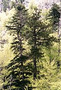
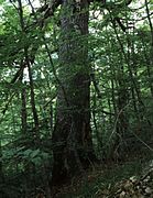
[edit]Mostly limestone rocks but also moraines and screes. Coastal cliffs are present at all parts of the Bay of Kotor. Many forest types can be seen of which Mediterranean deciduous evergreen don't play a significant role.Dinariccalcareous fir forests are found in several grooves on the Bijela gora but are difficult to reach.Bosnian pineforests are quite widespread on all major ridges. Virgin woodlands still exist, mainly Beech forests.
-
 Sinkhole on Mount Orjen
 -
 Firs are sung in local songs
 -
 Pasture Pirina poljana
 -
 Glaciokarst features atReovačka greda


Vegetation
[edit]| Zone [m] | Type | Vegetation (Biotopes) |
|---|---|---|
| 0- 400 | MesomediterraneanME= Meridional (subtropic belt) | Rusco-carpinetum(Ruscus aculeatus,Carpinus orientalis),Orno-Quercetum ilicis(Quercus pubescens,Quercus cerris,Juniperus communis,Quercus ilicis),Nerion oleandri(Nerium oleander) |
| 400- 1,100 | SupramediterraneanSME= Suprameridinal (subtropic belt) | Quercus trojana(Quercus trojana),Carpinus orientalis(Carpinus orientalis),Petterio-Quercetum confertae(Fuk.) Lov. (Petteria,Quercus conferta),Castaneo-Quercetum pubescentis(Anic) Lov. (Castanea sativa,Quercus pubescens),Seslerio-Ostryetum carpinifoliaeHorv. (Sesleria sphaerocephala,Sesleria caerulea,Ostryacarpinifolia) |
| 1,100- 1,450 | OromediterraneanNE= Nemoral (temperate zone) | Seslerio autumnalis–Fagetum(Horv.) Wrab. (Sesleria autumnalis,Fagus sylvatica),Pinion heldreichii(Pinus heldreichii),Oreoherzogio-Abietetum illyricaeFuk. (basic soil,Abies alba),Seslerio autumnalis–Abietetum illyriacae(Horv.) Fuk. |
| 1,450- 1,700 | AltimediterraneanBO= Boreal (taiga zone) | Fago-Pinetum heldrecihiiJank. (Fagus sylvatica,Pinus heldreichii),Seslerio robustae-Juniperetum hemisphaericae(Hor.) Kus. (Sesleria robusta,Juniperus communis ssp. Haemispherica),Lonicero-RhamnionFuk. (Lonicera nigra,Lonicera alpigena,Rhamnus),Amphoricarpion neumayerii(Horv.) Lak. (Amphoricarpos neumayerii) |
| 1,700- 1,900 | CryomediterraneanAL= Alpine (tundra zone) | Trifolio PolganetaliaQuéz (Trifolium),Narcisso-Gentianetum nivalisLov. & Rac (Narcissus,Gentiana nivalis),Drabo-AndrosacetaliaQuéz (Drabahoppeanae,Androsace alpina),Muscaro-Scillion nivalisQuéz |
- Notes:
- The Vegetation profile on Mount Orjen shows the Mediterranean zones which vary from alpine mountain zones.
- The few plant names are just examples of the plants belonging to the Biotope communities.[1]
- An example of a complete biotope plant list (Oreoherzogio-Abietetum illyricaeFuk.):Dinaric calcareous block fir forest#Plant list
- GenusSesleria,belongs tosubfamilyPooideae,of the true grassfamilyPoaceae.

Across Orjen vegetation varies with climate and altitude. While the sub-adriatic range exhibitsevergreendeciduousforests, the vegetation graduates totemperateforests,conifersandtundrain the northern and upper regions. The ridges also have a variety of Mediterraneanalpinevegetation – oromediterranean pastures. The typical karst country with bare limestone rochocks interspersed with parches of wood is found on lower altitudes. WhiteOak,Hop-hornbeam and MontpellierMaple,or the characteristicscrubof themaquis shrublandandgarrigueare notable. There are stony meadows in the sunkendolinaof thekarstthat contrast vividly with the stony slopes and rockyscrublandall round. Higher altitudes are characterised by heavybeechforest with occasional open grassy pastures. On northern branchessilver firaccompanies beech. Above the beech and fir-beech forests are scattered open stands of pureDinaric calcareous Silver Fir forestsandBosnian pinewith deep-purple youngconesset among stiff light-green needles. Open stonyscreesand rocks are exposed to the jagged ridges and summits. They are very rich in species.
Flora
[edit]Flora is of Balkan type with many Illyrian and Balkan endemics. Notable is local endemism with 10 endemics restricted to Mount Orjen.
Gallery
[edit]-
 Saxifragaspecies
 -
 Variety ofMartagon lily
 -
-
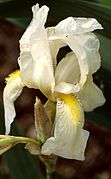 Iris orjeniiis endemic to altimediterrranean pastures on Orjen
 -
 Variety F. gracilisis common in the altimediterranean lifezone
 -
 Viburnum maculatumendemic snowball from Orjen
 -
 Very rarePaeonia daurica
 -
 Acer heldreichiisubendemic Greek Maple
 -
 Afir treein the range


Conservation
[edit]ANational Parkwas planned for a long time on Orjen. The disintegration of Yugoslavia, civil war and standstill of tourism cancelled plans. Today plans a rejuvenated but funding maybe a problem.UNESCOdeclared theNatural and Culturo-Historical Region of KotoraWorld Heritagesite. The part of Orjen within the boundaries of this Site is namely the Krivosije plateaux. A further evaluation of the patrimony and nomination of a greater part of Orjen as National park has good reasons. Uniqueflora,faunaand relief certainly require a protection plan by administrative action.
History
[edit]The earliest historic confirmations are the Lipce rock paintings which are dated in the Bronze Age. The first historic significant events are connected with theIllyrianswhenQueen Teuta,reigned approximately from 231 BC to 228 BC choose Risan as her capital during her war against the Romans. The Greek also colonised the region and eventually the Romans took over. The classical name of the Bay of Kotor is after Rhizon (Risan) Sinus Rhizonicus. EventuallyKotorwas becoming more important during theMiddle Ages
People
[edit]
Only few traditional shepherds live today on Orjen. Mostly remain on the northern side of the Bijela gora. They have their local songs describing life on the remote mountain and every year in July a great feast takes place when all the shepherds from Bijela gora come together to sing dance and eat on a pasture at Ledenik.
Livestock is mostly sheep but also horses and few cattle are held. At Orjen saddle oxen graze. In former times nomadic migration took place between thepoljesand the higher regions of Orjen. The traditional housing on Orjen is the so-calledKoliba.Small limestone huts with roofs build of pine bark. Only few hamlets are inhabited, mostly close to the coast. The higher up the stronger the push factors acted to leave. Tribes on Orjen were once renowned for their wildness and still people from the coast have this notion towards the mountain tribes.
Activities
[edit]Glacial and karst features compose a unique landscape that is attracting visitors also from abroad. Backpacking and alpine recreation are important factors for the development of the Orjen region. Three mountain huts are established and enthusiasts keep winter sports alive.
Hiking
[edit]
Trails are maintained by the PSD Subra mountaineering association fromHerceg Novi.Most trails are around the huts at Vratlo (1160 m) and Orjen ridge (1594 m). 40 km of marked trails exist in the Mount Orjen region, leading to the most attractive destinations. Marked trails start at the city bus station at Herceg Novi (30 m) and lead to the Vratlo hut (1160 m). Hiking in other more remote parts is also possible but no marcation currently exists. Visitors of Bijela gora or Dobri can use several local forest roads. sometimes shepherds can offer night accommodation.
Water is only available at some places, shepherd villagers usually use rain collectors. Most hikers tend to visit Subra (1680 m) or Veliki kabao (1895 m). Both are well marked.
Brown bears appear in the Bijela gora and should not be disturbed as the population is critically endangered.
Every year around mid May a half marathon called Orjen marathon is organised by the PSD Subra alpine organization. Guests are welcomed to take part in the traditional manifestation
Climbing
[edit]Several interesting alpine like climbing possibilities like rock climbing exist. Most remarkable is the 500 m wall of the Subra amphitheatre. In last few years the alpine – speleo section (A.S.O.S.) of PSD Subra started to climb routes on Mount Orjen. Good climbing routes are only 10 minutes walk from the Vratlo mountain hut. Other good climbing routes are in Subra's Amphitheatre and Reovacka Greda rocks. Mount Orjen gives a lot opportunities for climbing unclimbed routes with various difficulties.
| Peak | Height (m) | Character | Difficulty |
|---|---|---|---|
| Veliki kabao | 1,894 | rock scramble, wall, scree | difficult north approach, alpine character, scree on east |
| Velika Jastrebica | 1,865 | trail | easy trail |
| Buganja greda | 1,849 | rock scramble, scree | basic rock scramble, difficult slippery scree on north side |
| Visoki brijeg | 1,833 | rock scramble, scree, trail | basic rock scramble, scree on north |
| Vučji zub | 1,805 | rock scramble scree, wall | scree on east, difficult rock crevices on north |
| Borovik | 1,777 | rock scramble, scree | difficult scree on north, |
| Međugorje | 1,769 | rock scramble, wall | difficult major wall from north, south and west |
| Goliševac | 1,721 | rock scramble, scree | difficult scrre from north |
| Markov kuk | 1,721 | rockscramble, trail, scree | basi scramble |
| Pazua | 1,680 | rock scramble, wall | difficult rock scramble |
| Subra | 1,679 | rock scramble, big wall | 500 m wall still unclimbed |
Summer activities
[edit]- Backpacking– Between late spring and early fall. All overnight trips into the back country require sufficient water supplies due to limited water sources available.
- Bicycling –Mountain bikingis possible throughout Mount Orjen and local roads are well suited for cycling.
- Swimming – Orjen is located near theBay of Kotoron theAdriaticcoast.
- Orjen marathon– Annual sport event with several possible tracks, starting from the Vratlomountain huttowardsSubra(1679m) andVeliki kabao(1895m) peaks.
Winter activities
[edit]Much of Mount Orjen is inaccessible due to heavy snow in winter. However, Orjen saddle 1594 m can be reached in winter from Vrbanj.
- Skiing– the only skiing area is around Orjen saddle opens in winter. No lifts and equipment are provided at the mountain hut.
- Hunting– Hunters are generally welcome official permits are required.
References
[edit]- Pavle Cikovac: "Sociology and ecology of Silver Fir forest on Mt. Orjen – Montenegro". LMU Munich (2002), Department of Geography
| International | |
|---|---|
| National | |