
Peene
This articleneeds additional citations forverification.(December 2009) |
| Peene | |
|---|---|
 Peene river nearJarmen | |
 Peene river, its affluents, and Peenestrom strait | |
| Location | |
| Country | Germany |
| State | Mecklenburg-Vorpommern |
| Cities | Demmin,Anklam |
| Physical characteristics | |
| Source | Westpeene |
| • location | Vollrathsruhe |
| • elevation | 30 m (98 ft) |
| 2nd source | Ostpeene |
| • location | Schloen |
| • elevation | 80 m (260 ft) |
| 3rd source | Kleine Peene (Teterower Peene) |
| • location | Groß Wokern |
| • elevation | 85 m (279 ft) |
| Mouth | Peenestrom |
• location | Anklam |
• coordinates | 53°51′46″N13°48′52″E/ 53.86278°N 13.81444°E |
• elevation | 0 m (0 ft) |
| Length | 138.5 km (86.1 mi) |
| Basin size | 5,110 km2(1,970 sq mi) |
| Discharge | |
| • average | 20.6 m3/s (730 cu ft/s) |
| Basin features | |
| Tributaries | |
| • left | Trebel |
| • right | Tollense |
ThePeene(German:[ˈpeːnə]) is ariverinGermany.
Geography
[edit]TheWestpeene,with theOstpeeneas its longer tributary, and theKleine Peene/Teterower Peene(with aPeenewithout specification (orNordpeene) as its smaller and shorter affluent) flows intoKummerower See(Lake Kummerow), and from there as Peene proper toAnklamand into theOder Lagoon.
The western branch of theOder River,which separates the island ofUsedomfrom the German mainland, is often also called Peene, but actually is considered a part of the Baltic Sea called thePeenestrom.It is one of three channels connecting the Oder Lagoon with theBay of Pomeraniaof theBaltic Sea.(The other two are theŚwinaand theDziwna.)
-
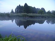
 Ostpeene
 -
 Old watermill on Kleine Peene inTeterow
 -
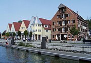
 Peene harbour inDemmin
 -
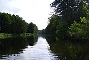
 Peene river nearLoitz
 -
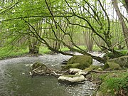
 Peene river nearJarmen
 -
 Peene river inAnklam
 -
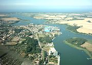 Peenestrom strait withWolgast
 -
 Peenestrom harbour inWolgast


Hydrography
[edit]The Peene river itself has some properties of an inlet. FromKummerower See,inclusively, to the mouth, the ground of the water is five feet and more below sea level. Thewindkessel effectof the large surface of this lake allows reverse flows that with northern wind may last as long as a week. These reverse flows do not only occur in times of low discharge of its effluent, but also in times of an overflow of precipitation.


Ecology
[edit]ThePeene Valleyis one of the largest contiguousfenregions in central Europe.[1]Thanks to its wilderness and intact nature, the river Peene and its valley is sometimes grandiloquently referred to as "theAmazonof the North ".[2]
Major towns at the Peene river areMalchin,Teterow,DemminandAnklam.
Wolgastis onPeenestromstrait.
References
[edit]- ^Peenetal / Peene-Haff-MoorArchived2012-01-14 at theWayback Machineat www.bfn.de.
- ^Peene: Paddeln auf dem Amazonas des Nordens(Spiegel Online)
External links
[edit] Media related toPeeneat Wikimedia Commons
- www.peenetal-landschaft.de- Association for natural protection of the Peene river valley (German)
| International | |
|---|---|
| National | |