
Piha
Piha | |
|---|---|
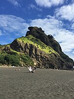
 Piha andLion Rockfrom the access road above | |
 | |
| Coordinates:36°57′14″S174°28′16″E/ 36.954°S 174.471°E | |
| Country | New Zealand |
| Region | Auckland |
| Ward | Waitākere ward |
| Local board | Waitākere Ranges Local Board |
| Electorates | |
| Government | |
| • Territorial Authority | Auckland Council |
| Area | |
| • Total | 5.24 km2(2.02 sq mi) |
| Population (June 2023)[2] | |
| • Total | 1,070 |
| • Density | 200/km2(530/sq mi) |

Pihais a coastal settlement inWest Auckland,on the western coast of theAuckland Regionin New Zealand. It is one of the most popular beaches in the area and a major day-trip destination for Aucklanders throughout the year, and especially in summer.
Piha is 39 kilometres west ofAucklandcity centre, on theTasman Seacoast to the north of theManukau Harbour,on the western edge of theWaitākere Ranges.Immediately to the north of Piha isWhites Beach,and immediately to the south isTe Unuhanga-a-Rangitoto / Mercer Bay;land access to both is only by foot. The nearest beaches accessible by road areKarekareto the south, andAnawhatato the north.
History
[edit]The area is traditionally a part ofroheof theTāmaki MāoritribeTe Kawerau ā Maki.[3]The area is named for Te Piha, the traditional name ofLion Rockwhich was later applied to the wider area,[3]and refers to the pattern made when waves hit against the rock.[4]The area was the location of manypāand villages, including a headland at Te Waha Point north of the beach, where manykarakatrees associated with the former pā grow,[5]and Lion Rock, which was the location of Whakaari pā.[6]Archaeological surveys have shown the remains of platforms,middenand terraces on Lion Rock, as well as fragments oftraditional textiles,dating back to a time before European contact.[6]The earthworks of Whakaari pā are not well preserved due to erosion.[5]
Te Unuhanga-a-Rangitoto / Mercer Bayto the south was traditionally known by the name Te Unuhanga o Rangitoto, referencing the traditional story of Te Kawerau ā Maki of early ancestorTiriwa,who formed the bay by movingRangitoto Islandfrom the West coast to theHauraki Gulf / Tīkapa Moana.[7]The English language name references Andrew Mercer, an Auckland settler who receivedCrowngrant in June 1866.[7]
At the turn of the 20th century, holidaymakers would travel by coach fromGlen Edento stay at guest houses in Piha.[8]In February 1939, two Australian visitors to Auckland, G R Mackey and J A Talbot, committed arson at a Pihabach.The fire was lit as a part of an insurance scam, and a body of a recently buried soldier was taken fromWaikumete Cemeteryand placed inside the bach.[9]
Demographics
[edit]Piha covers 5.24 km2(2.02 sq mi)[1]and had an estimated population of 1,070 as of June 2023,[2]with a population density of 204 people per km2.
| Year | Pop. | ±% p.a. |
|---|---|---|
| 2006 | 822 | — |
| 2013 | 858 | +0.61% |
| 2018 | 984 | +2.78% |
| Source:[10] | ||
Piha had a population of 984 at the2018 New Zealand census,an increase of 126 people (14.7%) since the2013 census,and an increase of 162 people (19.7%) since the2006 census.There were 396 households, comprising 498 males and 486 females, giving a sex ratio of 1.02 males per female. The median age was 43.4 years (compared with 37.4 years nationally), with 189 people (19.2%) aged under 15 years, 108 (11.0%) aged 15 to 29, 561 (57.0%) aged 30 to 64, and 129 (13.1%) aged 65 or older.
Ethnicities were 94.8% European/Pākehā,13.4%Māori,3.4%Pacific peoples,3.0%Asian,and 2.1% other ethnicities. People may identify with more than one ethnicity.
The percentage of people born overseas was 19.2, compared with 27.1% nationally.
Although some people chose not to answer the census's question about religious affiliation, 66.8% had no religion, 18.9% wereChristian,0.3% hadMāori religious beliefs,0.3% wereHindu,0.6% wereBuddhistand 4.6% had other religions.
Of those at least 15 years old, 279 (35.1%) people had a bachelor's or higher degree, and 48 (6.0%) people had no formal qualifications. The median income was $42,700, compared with $31,800 nationally. 198 people (24.9%) earned over $70,000 compared to 17.2% nationally. The employment status of those at least 15 was that 429 (54.0%) people were employed full-time, 129 (16.2%) were part-time, and 21 (2.6%) were unemployed.[10]
Features and geology
[edit]
As well as two surf beaches there are also a sheltered lagoon and several streams in the area. The coastline and forested Waitākere Ranges offer a number of walks, or tramps, ranging from easy to very difficult. Due to the spread of the incurablekauri diebackdisease large parts of the Waitākere Ranges were closed from 2018 until further notice.[11]
Piha is a well known black sand beach, due to the high iron content, which originated fromMount Taranakiand earlier volcanoes in the area.[12]
Lion Rockis a natural formation dividing North and South Piha beaches. It is an eroded 16-million-year-old[13]volcanic neck,[14]named for its similarity to a lying male lion when viewed from the rear (shore side), Lion Rock is immediately visible to visitors as they descend along the only access road. Lion Rock has become iconic not only of Piha, but of Auckland's West Coast in general. Lion Rock was featured on stamps as well as an Auckland phone book, and in December 1919 a memorial to local sawmillers who served in World War One was unveiled on Lion Rock.[15]

About 2 km inland, on the Glen Esk stream, are theKitekite Fallswhich while not very large are picturesque. Swimming is possible all seasons (though only for the cold hardened outside of summer) in a pool just above the falls. At the bottom of the falls is a sheltered picnic area popular with families in the summer time. There is another pool between the top falls and the bottom falls, but is closed due to Kauri dieback.
About 2 km inland, on thePiha Stream,is a small canyon.[16]
About 1 km south of the South Beach is 'The Gap', which at low tide provides another lagoon and ablowhole.
Surfing
[edit]
Piha was the birthplace of New Zealand board riding in 1958, and has been the scene of both New Zealand national and international surfing championship competitions.
Surf lifesaving
[edit]Twosurf lifesavingclubs provide surf patrols in summer.Piha Surf Life Saving Club,the home of the TV seriesPiha Rescue,patrols the section of the beach to the south of Lion Rock.United North Piha Lifeguard Serviceis responsible for the section of the beach north of Lion Rock. Both clubs provide patrolled areas designated by red and yellow flags as is the custom with Surf Lifesaving in New Zealand and many other countries.
Safety information
[edit]Therip currentsalong this section of coast are very unpredictable and can shift with little warning. They claim many lives despite the efforts of surf life-savers. Most of these drownings, however, occur after lifeguards are off duty or after rock fisherman wearing heavy clothing are washed off rocks, out of sight of the lifeguards. Lifeguards advise swimming between the red and yellow flags, during patrol hours.
After the death of two men at Piha in February 2013, lifeguards say the water fools swimmers by appearing deceptively calm, obscuring strong rips, and people should stay out of the water if they are not confident swimmers.[17]
Since 1992, six people have disappeared from or in the area of Piha with no trace, with one of the more publicised cases beingIraena Asherand the most recent being French teenager Eloi Rolland. No trace has been left by any of these people, and none of them have been found.[18]
Piha Rescue
[edit]Piha Beach was the setting for a popular New Zealandreality televisionshow. Aptly namedPiha Rescue,it ran for 12 series over 14 years onTV1and it featured the lives of the surf life savers at Piha Beach and educated the public on the beach safety, rip currents and swimming between the flags.[19]
Photo gallery
[edit]
-
 North to Lion rock and Te Waha Point
 -
 Toetoe plumes and Lion Rock
 -
 Aerial view of Piha Beach and Lion Rock
 -
 A view over Piha beach
 -
 A view of lion's rock from the beach


References
[edit]- ^ab"ArcGIS Web Application".statsnz.maps.arcgis.com.Retrieved24 June2022.
- ^ab"Population estimate tables - NZ.Stat".Statistics New Zealand.Retrieved25 October2023.
- ^abTe Kawerau ā Maki;The Trustees of Te Kawerau Iwi Settlement Trust;The Crown(22 February 2014)."Te Kawerau ā Maki Deed of Settlement Schedule"(PDF).Retrieved10 May2022.
- ^Cameron, Ewen;Hayward, Bruce;Murdoch, Graeme (2008).A Field Guide to Auckland: Exploring the Region's Natural and Historical Heritage(Revised ed.). Random House New Zealand. p. 174.ISBN978-1-86962-1513.
- ^abDiamond, John T.;Hayward, Bruce W.(1990). "Prehistoric Sites in West Auckland". In Northcote-Bade, James (ed.).West Auckland Remembers, Volume 1.West Auckland Historical Society. pp. 33–34, 36.ISBN0-473-00983-8.
- ^abMcKendry, Lisa (2017)."Māori Kākahu (Cloak) Fragments from Piha: Whakaari Pā".Records of the Auckland Museum.52:59–70.doi:10.32912/RAM.2018.52.4.ISSN1174-9202.JSTOR90016662.WikidataQ104815051.
- ^abMurdoch, Graeme (1992). "Wai Karekare - 'The Bay of the Boisterous Seas'".In Northcote-Bade, James (ed.).West Auckland Remembers, Volume 2.West Auckland Historical Society. p. 13.ISBN0-473-01587-0.
- ^Vela, Pauline, ed. (1989). "From Four Horses to Four Wheels".In Those Days: An Oral History of Glen Eden.Glen Eden Borough Council. pp. 80–81.ISBN0-473-00862-9.
- ^Vela, Pauline, ed. (1989). "Piha Fire Case and the Body Taken from Waikumete Cemetery".In Those Days: An Oral History of Glen Eden.Glen Eden Borough Council. p. 93.ISBN0-473-00862-9.
- ^ab"Statistical area 1 dataset for 2018 Census".Statistics New Zealand. March 2020. Piha (124100).2018 Census place summary: Piha
- ^Council, Auckland."Protect our kauri trees".Auckland Council.Retrieved4 September2018.
- ^Ingram, John(2011). "Steel from Ironsand". InLa Roche, John(ed.).Evolving Auckland: The City's Engineering Heritage.Wily Publications. pp. 245–261.ISBN9781927167038.
- ^"Geology of Waitākere Ranges".
- ^Ewen Cameron; Bruce Hayward; and Graeme Murdoch (1997).A Field Guide to Auckland: Exploring the Region's Natural and Historic Heritage,p. 168. Godwit Publishing Ltd, Auckland.ISBN1-86962-014-3.
- ^'Roll of Honour Unveiled', New Zealand Herald, 8 December 1919, Page 10.
- ^"www.newzealand.com".Archived fromthe originalon 22 May 2010.Retrieved13 May2011.
- ^"Be careful in the water, urges lifeguard".3 News NZ.25 February 2013.
- ^Thomas, Jackson; Anderson, Ryan (3 January 2021)."The missing people of Piha: 25 years, six cases, no answers".Stuff.
- ^Rescue, Piha."Piha Rescue Cancelled".
External links
[edit]- Piha.co.nz - News, History, Environment and Information
- About Piha. A History of Surfing in Piha.
- Photographs of Pihaheld inAuckland Libraries'heritage collections.
- Photographs of buses to Piha -1940s[1],[2].