
Podunavlje
Podunavljeis the name of theDanuberiver basin parts located inCroatia(Slavonia,Syrmia,andBaranya) andSerbia(Vojvodina,BelgradeandEastern Serbia). Podunavlje is located on the southern edge ofPannonian Basin.In its wider meaning, theCroatianterm refers to the area around the entire flow of the riverDanube.[1]
Naming history
[edit]In the first half of the 18th century,Sava-Danube (Posavina-Podunavlje) section of theHabsburgMilitary Frontierexisted in the area. Podunavlje segment of the Frontier comprised parts of southernBačkaand northernSyrmiaincluding towns ofPetrovaradin,Šid,Bačka Palanka,Bački Petrovac,Petrovaradinski Šanac(Novi Sad), andTitel.

Between 1922 and 1929, Podunavlje Oblast was one of the administrative units of theKingdom of Serbs, Croats and Slovenes.It included parts ofŠumadijaandBanatregions and its seat was inSmederevo.Between 1929 and 1941, one of the provinces of theKingdom of Yugoslaviawas known as theDanube Banovina.The province consisted of the geographical regions ofSyrmia,Bačka,Banat,Baranya,Šumadija,andBraničevo.The capital city of the Danube Banovina wasNovi Sad.In 1941, theWorld War IIAxis Powersoccupied the province. Bačka and Baranya regions were attached toMiklós Horthy'sHungary,while Syrmia was attached to theIndependent State of Croatia.The remaining rump Danube Banovina (including Banat, Šumadija, and Braničevo) existed as part ofGerman-occupiedSerbiauntil the end of 1941 with its capital atSmederevo.Today, Smederevo is seat of thePodunavlje DistrictofSerbia.
Between 1980 and 1989,Podunavljewas a name of one of the former seven municipalities ofNovi Sad Cityin Serbia.
Eastern Slavonia, Baranya and Western Syrmia(1991–1998), the eastern portion of theRepublic of Serbian Krajina,was sometimes called 'Podunavska Krajina' bySerbsor 'Croatian Podunavlje' byCroats.
Cities and towns in Podunavlje
[edit]List of cities and towns located on the river Danube in Podunavlje.
Cities and towns in Serbia:[2]
| City / town | Status | Location | Population (2011) |
|---|---|---|---|
| Apatin | center of municipality | Vojvodina | 17,352 |
| Bačka Palanka | center of municipality | Vojvodina | 27,924 |
| Beočin | center of municipality | Vojvodina | 7,800 |
| Futog | town | Vojvodina | 18,269 |
| Veternik | suburban settlement | Vojvodina | 16,895 |
| Novi Sad | the capital of Vojvodina |
Vojvodina | 221,854 |
| Sremska Kamenica | town | Vojvodina | 11,967 |
| Petrovaradin | center of municipality | Vojvodina | 14,298 |
| Sremski Karlovci | center of municipality | Vojvodina | 8,722 |
| Zemun (part ofBelgrade) |
center of municipality | Belgrade | 151,811 |
| Belgrade (includingZemun) |
the capital of Serbia |
Belgrade | 1,135,502 |
| Pančevo | the center of South Banat District |
Vojvodina | 73,992 |
| Smederevo | the center of Podunavlje District |
Southern and Eastern Serbia | 63,028 |
| Kovin | center of municipality | Vojvodina | 13,499 |
| Kostolac | center of municipality | Southern and Eastern Serbia | 9,264 |
| Veliko Gradište | center of municipality | Southern and Eastern Serbia | 5,868 |
| Kladovo | center of municipality | Southern and Eastern Serbia | 8,913 |


Cities and towns in Croatia:[3]
| City / town | Status | Location | Population (2011) |
|---|---|---|---|
| Beli Manastir[4] | town | Osijek-Baranja County | 10,068 |
| Vukovar | city, center of Vukovar-Srijem County |
Vukovar-Syrmia County | 27,683 |
| Ilok | town | Vukovar-Syrmia County | 6,767 |


Municipalities in Podunavlje
[edit]List of municipal areas connected to the river Danube in Podunavlje.
Municipalities in Serbia:[2]
Municipalities in Croatia:[5]
Podunavlje in Serbia
[edit]Geography and demographics
[edit]Northern part of Serbian Podunavlje is mostly flat, while southern part is mostly mountainous. Important rivers in Serbian Podunavlje that flowing intoDanubeareTisa,Sava,Tamiš,andMorava.Two largest cities of Serbia,BelgradeandNovi Sad,are located in Podunavlje. Podunavlje includes parts of several traditional geographical regions in Serbia. Such areBačka,Banat,Syrmia,Šumadija,Braničevo,and theTimok Valley.
Serbian Podunavlje is mainly populated bySerbs,while other smaller ethnic groups in the area areSlovaks,Hungarians,Croats,Rusyns,RomaniansandVlachs,Roma people,etc.Slovaksforming the majority of population in the municipality ofBački Petrovac,which is located near the Danube, inBačka.Main religion in the area isOrthodox Christianity,while other smaller religious groups areCatholic Christians,Protestant ChristiansandMuslims.
History
[edit]Podunavlje region in Serbia was an area where several important prehistoric cultures flourished, notably theLepenski Vir culture,theStarčevo culture,theVinča culture,theKostolac culture,theVatin culture,theBelegiš culture,etc. It was also a core of the Tribal State of CelticScordisci,which had its capital inSingidunum(present-dayBelgrade). Serbian Podunavlje was also a border region ofRoman Empireand there are archaeological remnants of Roman civilization in the area.
In the Migration Period and the Middle Ages, the region was part of theEastern Roman Empire,theHunnic Empire,theOstrogothic Kingdom,theKingdom of the Gepids,theLombard State,theAvar Khaganate,theFrankish Empire,theBulgarian Empire,thePrincipality of Lower Pannonia,theGreat Moravia,and theKingdom of Hungary.
Although, Serbo-Croatian speaking South Slavs settled in Serbian Podunavlje in the 6th century, Serbian state did not reach the river Danube before the 13th century. Kingdom ofSyrmiaruled by Serb kingStefan Dragutin(1284–1316) included southern Podunavlje and had its capitals inDebrcandBelgrade.The southern Podunavlje was subsequently included into other medieval Serbian states, notably theSerbian Empire,theMoravian Serbiaand theSerbian Despotate.The Serbian Despotate had its capitals in Podunavlje, notably inBelgradeandSmederevo.After the Ottoman conquest of Serbian Despotate in 1459, Serbian statehood was temporarily restored in northern Podunavlje (in present-dayVojvodina) between 1526 and 1530, during the reigns of emperorJovan Nenadand dukeRadoslav Čelnik.
In the 16th century, the whole region was included into theOttoman Empire.Subsequently, it became an area disputed between the Ottoman Empire and theHabsburg monarchy.After theTreaty of Belgradefrom 1739 which defined the Habsburg-Ottoman border in Podunavlje, the region, as well as the local Serb people, became divided between the two empires. In both these areas, Serb people fought for their autonomy and independence. After theFirstandSecondSerbian Uprising (in 1804 and 1815), an autonomous OttomanPrincipality of Serbiawas created in the south, while after theSerbian Uprising in Vojvodina(in 1848–1849), an autonomous AustrianVoivodeship of Serbia and Banat of Temeschwarwas created in the north. The two autonomous areas, however, did not have the same fate; while the northern voivodeship was abolished in 1860, the southern principality gained full independence in 1878 and was transformed into theKingdom of Serbiain 1882. In 1918, after the Habsburg defeat in theFirst World War,the northern Podunavlje was also included into theKingdom of Serbia,which subsequently became part of theKingdom of Serbs, Croats and Slovenes(later renamed toYugoslavia). Since 2006, the whole region is part of an independentRepublic of Serbia.
-
-
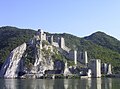
 Tabula Traiana nearKladovo


Podunavlje in Croatia
[edit]Geography and demographics
[edit]
In Croatia, region is elongated in a north–south along the Danube which is border river betweenCroatiaandSerbia.On the north region bordering withHungaryand on west continues toSlavonia,SyrmiaandBaranyaand rest of Croatia. The region is extremely flat with an average altitude of 80–110 meters. Coendures of Croatian Podunavlje are approximately overlapping with the territory of pre-War territory of Yugoslav municipalitiesBeli Manastir,Osijek,VinkovciandVukovar.[4]Those four municipalities had a territory of 3.436 kilometres and constituted 6,1% of territory of Socialist Republic of Croatia. In 1991 mentioned municipalities had 402.152 inhabitants living in 157 settlements and they constituted 8,4% of population of Croatia at the time.[4]After the collapse of Yugoslavia, local government system in Croatia was significantly changed and today Croatian Podunavlje in widest sense can be described as a region that is overlapping with the territory ofVukovar-SyrmiaandOsijek-Baranjacounties.[4]In this sense region include the gravitation regions of towns ofNašiceandŽupanjaand is significantly bigger and cover the area of 6.597 kilometres or 11,7% of territory of Croatia with 348 settlements and 598.434 inhabitants in 1991 (12,5% of total population of Croatia at that time).[4]
Climate in the region can be described as Continental climate with warm and hot summers and cold winters. Temperature ranges in Podunavlje are higher than in rest of Croatia due to the continent influence. Also level of rainfall is therefore lower than in the rest of Croatia.
It is one of the ethnically heterogeneous areas in Croatia. The largest ethnic group areCroats,after them followSerbsandHungarians,as well as some smaller ethnic groups such asPannonian Rusyns,Slovaks,Ukrainians,Romani people,Germans,etc. Croats constitute an absolute majority of people in Podunavlje, while Serbs make up largest ethnic minority. Hungarians are third ethnic group by number and mostly live in area of Baranya. Pannonian Rusyns live mainly inPetrovciandMikluševci.More than one-fifth of total number of Slovaks in country live inIlok.
-
 Catholic church inIlok
 -


History
[edit]
Some of the important archaeological cultures that appeared in this area are theVučedol culture,theVinča cultureand theStarčevo culture.Certainly, the most famous archaeological artifact is the ritual vessel of Vučedol culture, called by the speculative attribution of her founder (in 1938) M. Seper – the Vučedol Dove (vučedolska golubica). Made between 2800 and 2500 B.C. it became the symbol of style, culture and new arising European civilization. The Vučedol dove is a 19,5 cm high ritual vessel made from baked clay. This, as well, proves European pigeon breeding much older than we used to think. Moreover, Vučedol dove is the oldest dove figure found in Europe so far. The ritual vessel is depicted on the reverse of the Croatian 20 kuna banknote, issued in 1993 and 2001.
During theRomanperiod, Danube was border to barbarian world.

In period from 1991 till 1998 in Podunavlje there was self-proclaimed Eastern Slavonia, Baranya and Western Syrmia that was reintegrated intoCroatiaafter signing ofErdut Agreement.Region was declared by local Serbs who promoted survival ofYugoslavia,because of which they had support ofYugoslav People's Army.Local Serb population was further alarmed with comparisons of new Croatian state withWorld War IIIndependent State of Croatiaand itsJasenovac concentration camp.Warhas left a heavy mark on both the economy and the interpersonal relationships in region. There were especially strained relations between two largest groups, Croats and Serbs.
Some of the most important events of war in eastern Croatia areBattle of Vukovar,Vukovar massacre,andBorovo Selo killingsin which in first two cases was killed significant number of civilians. Large part of Croats were forced to leave their homes in Eastern Slavonia, Baranya and Western Syrmia, and their property was looted and destroyed. Some have been captured and imprisoned for some time in Serbia, and some were killed there. Tens of thousands of Croats in this period left Podunavlje. At the same time in Podunavlje came tens of thousands Serbian refugees fleeing from war in the rest of Croatia. After the war ended local population get a difficult task of rebuilding coexistence in which were included a number of organizations such as theOrganization for Security and Co-operation in Europeand embassies of foreign countries. However, although progress is slow at times international community has assessed this process as relatively successful. After the war, a number of towns and municipalities in the region were designatedAreas of Special State Concern.
Nature
[edit]
Kopački Rit:
Nature parkKopački Ritis located northwest of the confluence of theDravaand theDanube,situated at the border with Serbia. It is one of the most important, largest and most attractive preserved intactwetlandsinEurope.Around 260 various bird species nest here (wildgeeseandducks,great white egret,white stork,black stork,white-tailed eagle,crows, coots,gulls,terns,kingfishers,European green woodpecker,etc.), and there are many other species using this area as a temporary shelter onmigrationfrom the northern, cooler regions to the southern, warmer areas and vice versa.
There are 40-odd fish species (pike, ide, tench, bream, carp, catfish, pike-perch, perch, etc.). Several various mammal species inhabit the land (red deer,roe deer,wild boar,wild cat,pine marten,stone marten,weasel,sable,otter,etc.) Rich plant life, typical of wetlands, is found also in Kopački Rit.
See also
[edit]- Geographical regions in Serbia
- Podunavlje District
- Podunavlje, a formerly proposed new administrative division of Serbia, roughly corresponding to present-daySouthern and Eastern Serbia
- Danube Banovina
References
[edit]- ^Podunavlje, Enciklopedija Novog Sada, knjiga 20, Novi Sad, 2002, page 287.
- ^ab"2011 Census of Population, Households and Dwellings in the Republic of Serbia"(PDF).Statistical Office of the Republic of Serbia. 2011.Retrieved3 March2024.
- ^Archived5 March 2016 at theWayback Machine[dead link]
- ^abcdefghijklmnopqrDražen Živić (June 2003)."Prognano stanovništvo iz hrvatskog Podunavlja i problemi njegovog povratka (1991. – 2001.)"(PDF).Hrvatski Geografski Glasnik.65:63–81.doi:10.21861/HGG.2003.65.01.04.Retrieved20 September2016.
- ^"SAS Output".
Further reading
[edit]- Podunavlje, Enciklopedija Novog Sada, knjiga 20, Novi Sad, 2002.
- Geografski atlas, Magic Map, Smederevska Palanka, 2001.
- Denis Šehić – Demir Šehić, Geografski atlas Srbije, Beograd, 2007.

| Principal historical regions |  | ||||||||
|---|---|---|---|---|---|---|---|---|---|
| Smaller regions |
| ||||||||