
Ponte Nomentano
Ponte Nomentano (Pons Lamentanus) | |
|---|---|
 | |
| Coordinates | 41°56′01″N12°31′57″E/ 41.933611°N 12.5325°E |
| Carries | Via Nomentana |
| Crosses | Aniene |
| Locale | Rome,Italy |
| Characteristics | |
| Design | Fortifiedarch bridge |
| Material | Stone (incl.travertine), brick |
| Total length | 60 m |
| Width | 7.35 m |
| Longest span | 15 m |
| No.of spans | 3 |
| History | |
| Construction end | Probably 1st century BC |
| Location | |
 | |
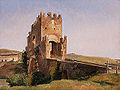
ThePonte Nomentano(calledPons Lamentanusduring theMiddle Ages) is aRoman bridgeinRome,Italy, which carried theVia Nomentanaover theAniene(Latin:Anio). Having lain outside the city limits for most of its history, the picturesque bridge is noted for its medievalbridge tower,which served to protect this important northern approach to Rome.
History
[edit]

Inantiquity,the Ponte Nomentano was located outside of theAurelian Wall,at a distance of 3.9 km from thePorta Nomentana.[1]TheEast RomanhistorianProcopiusrecords that the bridge was destroyed by theOstrogothsunder their kingTotilaaround 547 AD during theGothic War,but rebuilt by the victorious Roman generalNarsesin 552.[2]The still-intactlate Republicanfabric of the main arch, however, indicates that the bridge might have been only partially damaged in the event.[3]
The lower part of the bridge tower dates, according to an unproven tradition, from the time ofPope Adrian I(772–795). The imposing castle-like structure was constructed during a general overhaul of the bridge byPope Nicholas V(1447–1455), after which minor repairs followed in 1461, 1470, and 1474.[1]
A view of the bridge was painted by English artistJoseph Wright of Derbyin the 1770s.[4]The painting was later badlyoverpainted,[5]and it languished in theDerby Museumuntil it was rediscovered and restored in 2017, as documented by the television seriesBritain's Lost Masterpieces(series 2, episode 2).[6]
In 1849,Frenchtroops cut the bridge by 7 m to checkGaribaldi's advance on Rome, but it was soon restored.[7]
Today, the bridge is surrounded by a park, well within the municipal limits of Rome, and restricted to pedestrians.
Structure
[edit]The 31.30-meter-long superstructure of the Ponte Nomentano has, in essence, preserved its medieval character, while the dimensions of the bridge, which measure 60 m in overall length and 7.35 m in width, have remained practically unchanged since antiquity.[8]The 15-meter-wide central arch clearly dates back to ancient times, it is presumed from the late Republic or earlyAugustanPrincipate,as indicated by its semi-circular shape and the execution of thetravertinestonework.[9]Apart from this, only some further layers of travertine in the retaining walls can be assigned with certainty to the Roman period.[9]The two lateral brick arches were built in the reign ofPope Innocent X(1644–1655) in lieu of stone vaults.[1]
Further examples for fortified bridges across the Aniene include the RomanPonte SalarioandPonte Mammolo[10]and the medievalPonte di San FrancescoinSubiaco.
Gallery
[edit]-
 Painting of the Ponte Nomentano around 1837
 -
 During 2008 flood
 -
 Medieval bridge tower
 -
 Passageway


See also
[edit]References
[edit]- ^abcGalliazzo 1994,p. 37
- ^Procopius:De Bello Gothico,3.24
- ^Galliazzo 1994,pp. 37, 39
- ^"A View of the Ponte Nomentano, near Rome".Art UK.Retrieved2021-10-01.
- ^"View of the Ponte Nomentano, by Joseph Wright of Derby".Derby Museums.Retrieved2021-10-01.
- ^Grovesnor, Bender."Britain's Lost Masterpieces 2/2".BBC iplayer.BBC.Retrieved5 October2017.
- ^Galliazzo 1994,pp. 37–38
- ^Galliazzo 1994,pp. 38–39
- ^abGalliazzo 1994,p. 39
- ^O’Connor 1993,p. 68
Sources
[edit]- Galliazzo, Vittorio (1994),I ponti romani. Catalogo generale,vol. 2, Treviso: Edizioni Canova, pp. 37–39 (No. 21),ISBN88-85066-66-6
- O’Connor, Colin (1993),Roman Bridges,Cambridge University Press, p. 68 (I15),ISBN0-521-39326-4
External links
[edit]- Illustrated articleat Romeartlover
- Ponte NomentanoatStructurae

| International | |
|---|---|
| National | |
| Geographic | |