
Puerto Galera
This articleneeds additional citations forverification.(October 2012) |
Puerto Galera | |
|---|---|
| Municipality of Puerto Galera | |
 Sabang Bay | |
 Flag  Seal | |
| Motto: The Amazing Puerto Galera | |
| Anthem:The Amazing Puerto Galera | |
 Map of Oriental Mindoro with Puerto Galera highlighted | |
OpenStreetMap  | |
 Puerto Galera Location within thePhilippines | |
| Coordinates:13°30′00″N120°57′15″E/ 13.5°N 120.95417°E | |
| Country | Philippines |
| Region | Mimaropa |
| Province | Oriental Mindoro |
| District | 1st district |
| Founded | 1574 |
| Barangays | 13 (seeBarangays) |
| Government | |
| • Type | Sangguniang Bayan |
| •Mayor | Rocky D. Ilagan |
| •Vice Mayor | Marlon L. Lopez |
| •Representative | Paulino Salvador C. Leachon |
| •Electorate | 27,759 voters (2022) |
| Area | |
| • Total | 247.85 km2(95.70 sq mi) |
| Elevation | 429 m (1,407 ft) |
| Highest elevation | 2,571 m (8,435 ft) |
| Lowest elevation | 0 m (0 ft) |
| Population (2020 census)[3] | |
| • Total | 41,961 |
| • Density | 170/km2(440/sq mi) |
| •Households | 9,944 |
| Economy | |
| •Income class | 1st municipal income class |
| •Poverty incidence | 16.21 |
| •Revenue | ₱ 217 million (2020) |
| •Assets | ₱ 547.7 million (2020) |
| •Expenditure | ₱ 209.5 million (2020) |
| •Liabilities | ₱ 122.7 million (2020) |
| Service provider | |
| • Electricity | Oriental Mindoro Electric Cooperative (ORMECO) |
| Time zone | UTC+8(PST) |
| ZIP code | 5203 |
| PSGC | |
| IDD : area code | +63 (0)43 |
| Native languages | Iraya Tagalog |
| Website | www |
Puerto Galera,officially theMunicipality of Puerto Galera(Filipino:Bayan ng Puerto Galera), is a 1st classmunicipalityin theprovinceofOriental Mindoro,Philippines.According to the 2020 census, it has a population of 41,961 people.[3]
It is mainly accessible from the Southern Luzon gatewayport of Batangasby bamboo boats (bangka) operated by local regular operators. Seaplane Operator Air Juan Aviation, Inc. flies two daily flights from Manila to Puerto Galera on their Cessna Grand Caravan Seaplanes.
History[edit]

Chinese traders possibly knew the place before the arrival of the Spaniards but there is no evidence of Chinese settlement.[5]The place was likely also known by other Southeast Asian merchants, who would have found it convenient to load and unload trading goods. The state ofMa-iextended to the Puerto Galera area. The bay was a convenient place to shelter ships against bad weather, and a warehouse was built to store supplies and trade black rice from Muelle.[6]
In April 1570, the Spaniards arrived in Bombon (now known as Batangas), and later sailed through theIsla Verde Passage,landed and called the place Puerto Galera (the port of Galleons).Miguel López de Legazpibecame the first Spanishgovernor-generalof the island. A garrison for soldiers was built in Muelle, and watch towers were erected in Dampalitan Point to monitor naval activity in the bay. Spaniards came to conquer for their king and chased the MuslimMoro pirateswho were disrupting their trade with the Chinese and natives. The latter proved to be not only skilled warriors but also good negotiators even in the face of defeat.[5]
In 1663, a change in the form of administration occurred in the island, thecorregidorwas replaced by thealcalde-mayoror provincial governor, and the capital was moved from Puerto Galera to Baco. In the seventeenth century, the relative prosperity of the city underwent a serious setback with the rise of Muslim piracy.[7]Both pirates attacks and the mismanagement of the Spaniards resulted in driving the native population either into exile in safer places or sending them inland to comparative safety.
Geography[edit]
Puerto Galera is located at the north-westernmost part of Oriental Mindoro, and at the south-western end of theIsla Verde Passage,about 130 kilometres (81 mi) south ofManilaand 51 kilometres (32 mi) fromCalapan,the provincial capital.
Barangays[edit]
Puerto Galera is politically subdivided into 13barangays.Each barangay consists ofpuroksand some havesitios.
- Aninuan
- Baclayan
- Balatero
- Dulangan
- Palangan
- Poblacion
- Sabang
- San Antonio
- San Isidro
- Santo Niño
- Sinandigan
- Tabinay
- Villaflor
Climate[edit]
| Climate data for Puerto Galera, Oriental Mindoro | |||||||||||||
|---|---|---|---|---|---|---|---|---|---|---|---|---|---|
| Month | Jan | Feb | Mar | Apr | May | Jun | Jul | Aug | Sep | Oct | Nov | Dec | Year |
| Mean daily maximum °C (°F) | 28 (82) |
29 (84) |
30 (86) |
31 (88) |
31 (88) |
30 (86) |
29 (84) |
29 (84) |
29 (84) |
29 (84) |
29 (84) |
28 (82) |
29 (85) |
| Mean daily minimum °C (°F) | 22 (72) |
21 (70) |
22 (72) |
23 (73) |
25 (77) |
25 (77) |
25 (77) |
25 (77) |
25 (77) |
24 (75) |
23 (73) |
22 (72) |
24 (74) |
| Averageprecipitationmm (inches) | 48 (1.9) |
32 (1.3) |
41 (1.6) |
54 (2.1) |
257 (10.1) |
410 (16.1) |
466 (18.3) |
422 (16.6) |
429 (16.9) |
300 (11.8) |
137 (5.4) |
92 (3.6) |
2,688 (105.7) |
| Average rainy days | 10.8 | 8.0 | 9.8 | 11.7 | 23.1 | 27.5 | 29.2 | 28.7 | 28.7 | 25.5 | 18.2 | 12.8 | 234 |
| Source: Meteoblue(modeled/calculated data, not measured locally)[8] | |||||||||||||
Demographics[edit]
|
| ||||||||||||||||||||||||||||||||||||||||||||||||
| Source:Philippine Statistics Authority[9][10][11][12] | |||||||||||||||||||||||||||||||||||||||||||||||||
ThePhilippine Statistics Authoritycharacterizes the municipality of Puerto Galera as first class based on household income.[13]The municipality had a population of 32,521 in the 2010 national census. The population in 2012 was estimated to be 35,188.[14]
Economy[edit]
Poverty incidence of Puerto Galera
10
20
30
40
2006
35.40 2009
23.88 2012
11.00 2015
7.89 2018
13.25 2021
16.21 Source:Philippine Statistics Authority[15][16][17][18][19][20][21][22] |

The traditional economy of the city used to be fishing and subsistence agriculture, but with the boom of tourism at the end of the 1970s, the service sector became more and more important and led to population and economic growth.[23]Of the 13 villages ( "barangays" ) in Puerto Galera, half now rely on tourism-based activities for sustenance.[24]
In addition, Mindoro is quickly becoming one of the key places in the development of renewable energy in the Philippines. With several large wind, hydroelectric, and geothermal projects under construction, the island hoped in 2012 to be a net exporter of electricity by 2016.[25][26]
Tourism[edit]

Tourism now represents the core activity of the economy of Puerto Galera, which is well known for its beaches, scuba diving and entertainment activities, including "go-go bars". The city and its beaches have also become one of the many sites of the Philippines sex tourism industry.[27]
This coastal town has a number ofpocket beachesandsnorkelingandscuba divingspots. The area was designated aMan and Biospherereserve ofUNESCOin 1973 and has some of the most diverse coral reef diving in Asia. Since 2001, the marine environment has benefited from a huge reduction in the number of fishermen in the area, as they gain higher revenue from tourism activities.
Puerto Galera is included in the list of the "Club of the Most Beautiful Bays of the World", and is the only bay in the Philippines to be found on this list.[28]
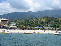
Among the beaches in Puerto Galera are Sabang Beach and White Beach, which have an active nightlife with numerous bars and restaurants. Both places are directly accessible from Batangas bybangkaregular lines. On the west, where is only a local boat connection toAbra de Ilog,the planned road between the two cities has not been completed yet. On the east, the city connects by road toCalapanthrough the Mindoro circular road.
Tourism[edit]
Diving and snorkeling[edit]

Puerto Galera, especially the Sabang area, is among the top diving destinations in the Philippines and in Asia.[citation needed]Diving sites are found less than five minutes from Sabang Beach.[citation needed]Diving activities generally focus around the areas either side of Escarceo Point. Marine life is diverse. There are over 180+ species ofnudibranchsfound in the area, and many species of fish can be seen. A variety of wrecks over the years can be found in addition to the one wreck of an engine of a WWII Japanese patrol boat. The major diving federations PADI, CMAS, NAUI andTechnical Diving International(TDI) are represented in the area, offering courses from beginners' open water to advanced and technical diving (rebreather,trimix). Diving trips in theVerde Island Passage,at the heart of theCoral Triangleare organized from Puerto Galera. Many threatened species such as a variety of sea turtles includinghawksbills,olive ridleys,andgreen turtles,humphead wrasses, giant groupers and giant clams are present in the Verde Island Passage.
Environment[edit]
The accelerated development of tourism jeopardizes the preservation of its delicate ecological system consumed by "overdevelopment due to a thriving but runaway free-market tourism".[29]Currently, this appears to be the "biggest problem" of Puerto Galera.[30]Accelerated tourist oriented development poses degradation to the environment, among which, seawater pollution brought about by improper sewage and wastewater discharges.[24]Unless serious action is taken, with regular seawater monitoring, this situation poses a serious threat to the sustainability of various tourist activities at the beaches.
In the summer of 1998, extensivecoral bleachingoccurred around Medio Island, and a large section of a shallowcoral reefsystem (referred to as the "Coral Gardens" ) died. Since then, the coral has regrown with a larger diversity of coral species replacing the prolific table corals. Corals in Puerto Galera were largely unaffected by the 2010El Niñoevent. The local government declared the 4,828 ha of municipal waters (12,690 ha) as protected waters, giving special protection to the corals and reef fishes.[31]
In 2006, twosuper typhoonsdamaged the shallow reefs around Escarceo Point. A major section of the faster-growing coral species growing up to a depth of 6 metres (20 ft) was destroyed. This represented about 5% of the coral reef in the area. Extensive signs of new coral recruitment were noted in mid-2008.Acroporaspecies (staghorn and table coral) rapidly recolonized the area so that most of the damaged coral has been replaced with new growth.
Gallery[edit]
-
 Puerto Galera white beach
 -
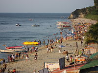 White Beach at sunset, looking towards the north-east end
 -
 Tamaraw Falls
 -
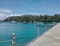 Muelle Port
 -
 Puerto Galera Church
 -
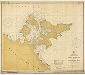 Nautical chart of Puerto Galera's harbor (1917)
 -
 Puerto galera underwater coral seascape with hydroid (Aglaophenia)
 -
 Two large feather stars anchored to coral
 -
 Juvenile fish seeking shelter in coral
 -
 Pink anemonefish with its sea anemone host
 -
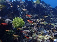 Underwater seascape with bright crinoid and tropical fish
 -
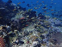 Underwater seascape
 -
 Underwater seascape
 -
 Coral
Coral -
 Coral
Coral -
 Turtle on a Puerto Galera coral reef


References[edit]
- ^ Municipality of Puerto Galera|(DILG)
- ^"2015 Census of Population, Report No. 3 – Population, Land Area, and Population Density"(PDF).Philippine Statistics Authority.Quezon City, Philippines. August 2016.ISSN0117-1453.Archived(PDF)from the original on May 25, 2021.RetrievedJuly 16,2021.
- ^abCensus of Population (2020)."Mimaropa".Total Population by Province, City, Municipality and Barangay.Philippine Statistics Authority.RetrievedJuly 8,2021.
- ^"PSA Releases the 2021 City and Municipal Level Poverty Estimates".Philippine Statistics Authority. April 2, 2024.RetrievedApril 28,2024.
- ^abLopez, Violeta B. (1974)."Culture Contact and Ethnogenesis in Mindoro up to the End of the Spanish Rule"(PDF).Asian Studies.12(1): 1–38.
- ^Kushwaha, U. K. S. (2016).Black Rice: Research, History and Development.Springer. p. 51.ISBN978-3-319-30153-2.
- ^Barrantes, Vicente (1878).Guerras piráticas de Filipinas contra mindanaos y joloanos, corregidas é ilustradas por Don Vicente Barrantes.Biblioteca Hispano-Ultramarina (in Spanish). Madrid: Imprenta de Manuel G. Hernández – via Biblioteca Digital de Castilla y León.
- ^"Puerto Galera: Average Temperatures and Rainfall".Meteoblue.RetrievedApril 27,2020.
- ^Census of Population (2015)."Region IV-B (Mimaropa)".Total Population by Province, City, Municipality and Barangay.Philippine Statistics Authority.RetrievedJune 20,2016.
- ^Census of Population and Housing (2010)."Region IV-B (Mimaropa)"(PDF).Total Population by Province, City, Municipality and Barangay.National Statistics Office.RetrievedJune 29,2016.
- ^Censuses of Population (1903–2007)."Region IV-B (Mimaropa)".Table 1. Population Enumerated in Various Censuses by Province/Highly Urbanized City: 1903 to 2007.National Statistics Office.
{{cite encyclopedia}}:CS1 maint: numeric names: authors list (link) - ^ "Province of Oriental Mindoro".Municipality Population Data.Local Water Utilities AdministrationResearch Division.RetrievedDecember 17,2016.
- ^"Philippine Standard Geographic Code (PSGC)".Philippine Statistics Authority.RetrievedFebruary 25,2022.
- ^"Demographic Profile".Official Website of Oriental Mindoro.Archived fromthe originalon February 2, 2017.RetrievedJanuary 27,2017.
- ^"Poverty incidence (PI):".Philippine Statistics Authority.RetrievedDecember 28,2020.
- ^"Estimation of Local Poverty in the Philippines"(PDF).Philippine Statistics Authority. November 29, 2005.
- ^"2003 City and Municipal Level Poverty Estimates"(PDF).Philippine Statistics Authority. March 23, 2009.
- ^"City and Municipal Level Poverty Estimates; 2006 and 2009"(PDF).Philippine Statistics Authority. August 3, 2012.
- ^"2012 Municipal and City Level Poverty Estimates"(PDF).Philippine Statistics Authority. May 31, 2016.
- ^"Municipal and City Level Small Area Poverty Estimates; 2009, 2012 and 2015".Philippine Statistics Authority. July 10, 2019.
- ^"PSA Releases the 2018 Municipal and City Level Poverty Estimates".Philippine Statistics Authority. December 15, 2021.RetrievedJanuary 22,2022.
- ^"PSA Releases the 2021 City and Municipal Level Poverty Estimates".Philippine Statistics Authority. April 2, 2024.RetrievedApril 28,2024.
- ^"Puerto Galera".UNESCO.2013.RetrievedJanuary 27,2017.
- ^abRubio, Maria Cecilia D.; Nadaoka, Kazuo; Pokavanich, Tanuspong; Iizuka, Hiroyasu; Blanco, Ariel C.; Paringit, Enrico C. (2006).Complementarity of Sensor Based Measurements and Community Perception for Monitoring and Management of Seawater Quality(PDF).Paper presented at the Symposium on Infrastructure Development and the Environment 2006, December 7–8, 2006, SEAMEO-INNOTECH, University of the Philippines, Diliman, Quezon City, Philippines.
- ^Evora, Robert A. (August 20, 2012)."Mindoro Wind Farm Dwarfs Ilocos Plant".Manila Standard Today.Archived fromthe originalon August 24, 2012.
- ^Flores, Alena Mae S. (September 23, 2013)."Mindoro Wind Farm Cleared".ManilaStandardToday.com.Archived fromthe originalon October 15, 2013.
- ^Wiss, Rosemary (2013)."And Justice for All? International Anti-Trafficking Agendas and Local Consequences in a Philippines Sex Tourism Town".Australian Journal of Human Rights.19(1): 55–82.doi:10.1080/1323-238X.2013.11882117.S2CID158752556– via Academia.edu.
- ^Membership in the France-basedClub of the Most Beautiful Bays of the World(Club des Plus Belles Baies du Monde) is obtained by application. The club is chartered to list only one bay per sea in a given country"Charte du Club des Plus Belles Baies".Club des Plus Belles Baies(in French). Archived fromthe originalon October 23, 2008.RetrievedNovember 21,2008..The club lists the Bay of Puerto Galera (Baie de Puerto GaleraArchivedDecember 11, 2008, at theWayback Machine) as being located at 13°3' NR, 120°75' in the E China Sea (southern) ( "E Mer de Chine (sud)" in French).
- ^Fortes, Miguel D. (1997).Puerto Galera: A Lost Biosphere Reserve?.South-South Co-operation Programme for Environmentally Sound Socio-Economic Development in the Humid Tropics Working Papers, No. 18. UNESCO. page 2, abstract.
- ^Sembrano, Edgar Allan M. (April 10, 2016)."Puerto Galera: A Biosphere Reserve in Distress".Lifestyle.Inq.RetrievedFebruary 25,2022.
- ^WWF Matching Grant Sulu Sulawesi Seas Marine Ecoregion Program CA Number HFP-A-00-02-00028-00 – Annual Report(PDF)(Report). WWF and USAID. 2008.RetrievedJanuary 28,2017– via usaid.gov.
External links[edit]
- Philippine Standard Geographic Code
- Local Governance Performance Management System
- Puerto GaleraatCurlie
 Puerto Galeratravel guide from Wikivoyage
Places adjacent to Puerto Galera | |
|---|---|
Calapan(capital and largest city) | |
| Municipalities | |
| Component city | |
| International | |
|---|---|
| National | |