
Puster Valley
Puster Valley | |
|---|---|
| Comunità comprensoriale Val Pusteria Bezirksgemeinschaft Pustertal | |
 Puster Valley (highlighted in green) within South Tyrol | |
| Country | |
| Autonomous region | |
| Autonomous province | |
| Established | 1969 |
| Administrative seat | Bruneck(Brunico) |
| Area | |
| • Total | 2,072 km2(800 sq mi) |
| Population (2005) | |
| • Total | 76,149 |
| • Density | 37/km2(95/sq mi) |
| Website | www |
ThePuster Valley[1][2](Italian:Val Pusteria[ˈvalpusteˈriːa];German:Pustertal,Ladin:Val de Puster) is one of the largest longitudinal valleys in theAlpsthat runs in an east-west direction betweenLienzinEast Tyrol,Austria,andMühlbachnearBrixeninSouth Tyrol,Italy.The South Tyrolean municipalities of the Puster Valley constitute the Puster Valley district.
Puster Valley
[edit]
The Puster Valley is located in the western part of thePeriadriatic Seam,which separates theSouthern Limestone Alpsfrom theCentral Eastern Alps,as well as most of thelimestoneAlps from the centralgneissandslatepeaks of the range's central section. East ofSillian,the Puster Valley leaves the Peradriatic Line (which moves into theGailvalley) and turns to the northeast towards Lienz.
Half of the valley drains to the west to theAdriaticvia theAdigeriver; the other half drains to the east to theBlack Seavia theDanube.The watershed lies in the shallow valley floor called Toblacher Feld (Conca di Dobbiaco). TheRienzriver flows westwards through the Puster Valley and theDrauriver flows eastwards intoEast Tyrol.The eastern part of the valley on the upper Drava is calledUpper Puster Valley.
The towns in the Puster Valley are located between 750 and 1,180 meters (2,460 and 3,870 ft) above sea level. The most important of these towns in the western valley areToblach,Welsberg-Taisten,Olang,andBruneck;the most important in the eastern valley areInnichen,Sexten,andSillian.
The largest tributaries of the Rienz river form theAntholzer Bach,theAhr,thePragser Bach,theGsieser Bach,theGran Ega,thePfunderer Bach,and theLüsenbach.The Puster Valley's largest side valley is theTauferer Ahrntal.The Drau's largest eastern tributaries are theSextner Bachand theVillgraten-Bach.
History
[edit]The Puster Valley was inhabited sinceprehistoric timesas finds belonging to theIron Agehave been found in that area. In more recent times this zone was inhabited by people belonging to theIllyrian stock:they were called "Saevates" by theRomans(hence the name "Sebatum" of the Roman station of today'sSaint Lawrence.) In the 6th century, theCelticinvaders merged with the Illyrian population.[3]Around the end of theI centuryB.C, the Rienz valley was mainly used by the Romans as an arterial road to connect the north-eastern regions of theEmpire.The Puster Valley belonged to theimperial provinceofNoricum,and the local populations, during the four centuries of the domination ofRome,began to assimilate the customs, the language and finally theChristian religion.In the 5th century theGoths,theBaiuvariiand theSlavsdecided to descend in this area, with consequent conflicts between Baiuvarii and Slavs, which ended with the Baiuvarii victory. In the 10th century the Puster Valley started to belong to the Pustrissa countship, firstly mentioned in 974 asPustrissaandPustrussa;[4]in 1091 the countship was ceded by the EmperorHenry IVto the Bishop of Brixen and in the 16th century theHapsburgtook possession of it. During theNapoleonic era,following the Austrian defeat at Austerlitz and thetreaty of Pressburgin 1805, the entire region passed to theBavaria:the Tyroleans, led by Andreas Hofer, repeatedly fought against the Bavarian domination.[5]After Napoleon's fall, the Puster valley was reunited withAustriaand, following theWorld War I,it was assigned toItaly.[6]
Opening in 1871 thePuster Valley Railwayuses the relative simple landscape to avoid climbing steep slopes.
Puster Valley District
[edit]
The Puster Valley District (Italian:Comprensorio della Val Pusteria;German:Bezirksgemeinschaft Pustertal) was founded in 1969 with the merger of 26 municipalities. Its combined area is 2,071 km² and its population is over 73,000. Its main town isBruneck.According to the 2001 census, 80.96% of the population of the valley speak German, 13.40%Ladin,and 5.64% Italian as their native language.[7]
The following municipalities are part of the Puster Valley District:
Gallery
[edit]-
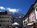
 Ahrntal and Bruneck
 -
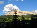
 Lienzer Dolomite range in East Tyrol in the Upper Puster Valley
 -
 Innichen
 -
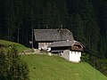 Farmhouse in the Antholz Mittertal valley
 -
 Heiligkreuzkofel in the Abteital valley


References
[edit]- ^Pignatti, Erika, & Sandro Pignatti. 2014.Plant Life of the Dolomites: Vegetation Structure and Ecology.Heidelberg: Springer, p. 612.
- ^Russ, Charles. 1990.The Dialects of Modern German: A Linguistic Survey.London: Routledge, p. 480.
- ^Puerari, Mariner (1955).Das Pustertal und seine Nebentäler.Bolzano. p. 6.
{{cite book}}:CS1 maint: location missing publisher (link) - ^Martin Bitschnau; Hannes Obermair (2009).Tiroler Urkundenbuch, II. Abteilung: Die Urkunden zur Geschichte des Inn-, Eisack- und Pustertals. Vol. 1: Bis zum Jahr 1140.Innsbruck: Universitätsverlag Wagner. pp. 124–5 no. 161.ISBN978-3-7030-0469-8.
- ^Paulin (1970).Andreas Hofer.pp. 16–131.
- ^Rovati, Paolo (1983). "Brunico, una piccola città della media valle della Rienza".Annali di ricerche e studi della geografia:65–82.
- ^Bevölkerung und soziales Leben, Statistisches Jahrbuch 2006,p. 120, tab. 3.19
External links
[edit] Media related toPuster Valleyat Wikimedia Commons
- Puster Valley District(in German and Italian)
| |||
46°44′N12°13′E/ 46.733°N 12.217°E
| International | |
|---|---|
| National | |