
Qinghai
Qinghai
Thanh hải | |
|---|---|
| Province of Qinghai | |
| Name transcription(s) | |
| •Chinese | Thanh hải tỉnh(Qīnghǎi Shěng) |
| •Abbreviation | QH /Thanh(pinyin:Qīng) |
     Clockwise from the top:
| |
 Map showing the location of Qinghai Province | |
| Coordinates:35°N96°E/ 35°N 96°E | |
| Country | China |
| Named for | Derived from the name ofQinghai Lake( "blue/green lake" ). |
| Capital (and largest city) | Xining |
| Divisions -Prefecture-level -County-level -Township- level | 8 prefectures 44 counties 404 towns and subdistricts |
| Government | |
| • Body | Qinghai Provincial People's Congress |
| •CCP Secretary | Chen Gang |
| • Congress Chairman | Chen Gang |
| •Governor | Wu Xiaojun |
| • ProvincialCPPCCChairman | Gönbo Zhaxi |
| •National People's CongressRepresentation | 24 deputies |
| Area | |
| • Total | 720,000 km2(280,000 sq mi) |
| • Rank | 4th |
| Highest elevation | 6,860 m (22,510 ft) |
| Population (2020)[2] | |
| • Total | 5,923,957 |
| • Rank | 31st |
| • Density | 8.2/km2(21/sq mi) |
| • Rank | 30th |
| Demographics | |
| • Ethnic composition | Han– 54% Tibetan– 21% Hui– 16% Tu– 4% Mongol– 1.8% Salar– 1.8% |
| • Languages and dialects | Zhongyuan Mandarin Chinese,Amdo Tibetan,Monguor,Oirat Mongolian,SalarandWestern Yugur |
| GDP(2023)[3] | |
| • Total | CN¥379,906 million (30th)
US$53,913 million |
| • Per capita | CN¥ 63,903 (24th)
US$ 9,069 |
| ISO 3166 code | CN-QH |
| HDI(2021) | 0.695[4](28th) –medium |
| Website | www |
| Qinghai | |||||||||||||||||||||||||||||||||||||||
|---|---|---|---|---|---|---|---|---|---|---|---|---|---|---|---|---|---|---|---|---|---|---|---|---|---|---|---|---|---|---|---|---|---|---|---|---|---|---|---|
"Qinghai" in Chinese characters | |||||||||||||||||||||||||||||||||||||||
| Chinese name | |||||||||||||||||||||||||||||||||||||||
| Chinese | Thanh hải | ||||||||||||||||||||||||||||||||||||||
| Postal | Tsinghai | ||||||||||||||||||||||||||||||||||||||
| Literal meaning | "Qinghai (Lake)" | ||||||||||||||||||||||||||||||||||||||
| |||||||||||||||||||||||||||||||||||||||
| Tibetan name | |||||||||||||||||||||||||||||||||||||||
| Tibetan | མཚོ་སྔོན། | ||||||||||||||||||||||||||||||||||||||
| |||||||||||||||||||||||||||||||||||||||
| Mongolian name | |||||||||||||||||||||||||||||||||||||||
| Mongolian Cyrillic | Хөхнуур | ||||||||||||||||||||||||||||||||||||||
| Mongolian script | ᠬᠥᠬᠡ ᠨᠠᠭᠤᠷ | ||||||||||||||||||||||||||||||||||||||
| |||||||||||||||||||||||||||||||||||||||
| Manchu name | |||||||||||||||||||||||||||||||||||||||
| Manchu script | ᡥᡠᡥᡠ ᠨᠣᠣᡵ | ||||||||||||||||||||||||||||||||||||||
| Romanization | Huhu Noor | ||||||||||||||||||||||||||||||||||||||
| Oirat name | |||||||||||||||||||||||||||||||||||||||
| Oirat | Kokonur | ||||||||||||||||||||||||||||||||||||||
Qinghai[a]is an inlandprovinceinNorthwestern China.It is the largestprovince of China(excluding autonomous regions) by area and has the third smallest population. Its capital and largest city isXining.
Qinghai bordersGansuon the northeast,Xinjiangon the northwest,Sichuanon the southeast and theTibet Autonomous Regionon the southwest. Qinghai province was established in 1928 during the period of theRepublic of China,and until 1949 was ruled byChinese Muslimwarlords known as theMa clique.TheChinesename "Qinghai" is afterQinghai Lake,the largest lake in China. The lake is known as Tso ngon in Tibetan, and as Kokonor Lake in English, derived from the MongolOiratname for Qinghai Lake. Both Tso ngon and Kokonor are names found in historic documents to describe the region.[7]
Located mostly on theTibetan Plateau,the province is inhabited by a number of peoples including theHan(concentrated in the provincial capital of Xining, nearbyHaidong,andHaixi),Tibetans,Hui,Mongols,Monguors,andSalars.According to the 2021 census reports, Tibetans constitute a fifth of the population of Qinghai and the Hui compose roughly a sixth of the population. There are over 37 recognized ethnic groups among Qinghai's population of 5.6 million, withnational minoritiesmaking up a total of 49.5% of the population.
The area of Qinghai came under the control of theManchu-ledQing Dynastyaround 1724, after their defeat ofKhoshutMongols who previously controlled most of the area. After theXinhai Revolutionand the ensuing fall of the Qing dynasty in 1912, Qinghai came under Chinese Muslim warlordMa Qi's control until theNorthern Expeditionby theRepublic of Chinaconsolidated central control in 1928. In the same year, the province of Qinghai was established by theNationalist Government,with Xining as its capital.[8][9][10]
History
[edit]During theBronze Age,Qinghai was home to a diverse group of nomadic tribes closely related to other Central Asians who traditionally made a living inagricultureandhusbandry,theKayue culture.The eastern part of the area of Qinghai was under the control of theHan dynastyabout 2,000 years ago. It was a battleground during theTangand subsequentCentral Plaindynasties when they fought against successiveTibetan tribes.[11]
In the middle of 3rd century CE, nomadic people related to theMongolicXianbeimigrated to pasture lands around theQinghai Lake(Koko Nur) and established theTuyuhun Kingdom.
In the 7th century, the Tuyuhun Kingdom was attacked by both theTibetan Empireand the Tang dynasty as both sought control over theSilk Roadtrade routes. Tibetan KingSongtsen Gampowas victorious, and settled the area around Tso ngon (Lake Go, or Kokonor Lake).[12]Military conflicts had severely weakened the Tuyuhun kingdom and it was incorporated into the Tibetan Empire. The Tibetan Empire continued expanding beyond Tso ngon duringTrisong Detsen's andRalpacan's reigns, and the empire controlled vast areas north and east of Tso ngon until 848,[13]which includedXi'an.
During thefragmentation of the Tibetan Empire,a series of local polities emerged under the political jostling ofWestern Xiato the north andSong dynastyto the east -- from the military-rule ofGuiyi Circuit,to a Tibetan tribal confederacy, and eventuallythe Tibetan theocratic kingdom of Tsongkha.TheSong dynastyeventual defeated the Kokonor kingdom Tsongkha in the 1070s.[14]During the Mongol-ledYuan dynasty'sadministrative rule of Tibet,the region comprised the headwaters of the Ma chu (Machu River,Yellow River) and the Yalong (Yangtze) rivers and was known asAmdo,but apportioned to different administrative divisions than Tibet proper.[15]
Most of Qinghai was, for a short time in the aftermath of the Yuan dynasty's overthrow, under the control of earlyMing dynasty,but later gradually lost to theKhoshut Khanatefounded by theOirats.TheXunhua Salar Autonomous Countyis where mostSalar peoplelive in Qinghai. The Salars migrated to Qinghai fromSamarkandin 1370.[16]The chief of the four upper clans around this time was Han Pao-yuan and Ming granted him office of centurion, it was at this time the people of his four clans took Han as their surname.[17]The other chief Han Shan-pa of the four lower Salar clans got the same office from Ming, and his clans were the ones who took Ma as their surname.[18]
From 1640 to 1724, a big part of the area that is now Qinghai was underKhoshutMongol control, but in 1724 it was conquered by the armies of theQing dynasty.[19]Xining,the capital of modern Qinghai province, began to function as the administrative center, although the city itself was then part ofGansuprovince within the "Tibetan frontier district".[20][21]In 1724, 13-Article for the Effective Governing of Qinghai (Chinese: Thanh hải thiện hậu sự nghi thập tam điều ) was proposed byNian Gengyaoand adopted by the Central Government to gain full control of Qinghai.
Under the Qing dynasty, the governor was a viceroy of the Emperor, but local ethnic groups enjoyed significant autonomy. Many chiefs retained their traditional authority, participating in local administrations.[22]TheDungan Revolt (1862–1877)devastated theHuiMuslim population ofShaanxi,shifting the Hui center of population toGansuand Qinghai.[23]: 405 AnotherDungan Revoltbroke out in Qinghai in 1895 when various Muslim ethnic groups in Qinghai and Gansu rebelled against the Qing. Following theoverthrow of the Qing dynastyin 1911, the region came under Chinese Muslim warlordMa Qicontrol until theNorthern Expeditionby theRepublic of Chinaconsolidated central control in 1928.
In July–August 1912, GeneralMa Fuxiangwas "Acting Chief Executive Officer of Kokonur" (de facto Governor of the region that later became Qinghai).[24]In 1928, Qinghai province was created. The Muslim warlord and GeneralMa Qibecame military governor of Qinghai, followed by his brotherMa Linand then Ma Qi's sonMa Bufang.In 1932Tibet invaded Qinghai,attempting to capture southern parts of Qinghai province, following contention inYushu,Qinghai, over a monastery in 1932. The army of Ma Bufang defeated the Tibetan armies. Governor of QinghaiMa Bufangwas described as asocialistby American journalistJohn Roderickand friendly compared to the other Ma Clique warlords.[25]Ma Bufang was reported to be good humoured and jovial in contrast to the brutal reign ofMa Hongkui.[26]Most of eastern China was ravaged by theSecond Sino-Japanese Warand theChinese Civil War,by contrast, Qinghai was relatively untouched.
Ma Bufang increased the prominence of the Hui andSalar peoplein Qinghai's politics by heavily recruiting to his army from the counties in which those ethnic groups predominated.[27]General Ma started a state run and controlled industrialization project, directly creating educational, medical, agricultural, and sanitation projects, run or assisted by the state. The state provided money for food and uniforms in all schools, state run or private. Roads and a theater were constructed. The state controlled all the press, no freedom was allowed for independent journalists.[28]
As the1949 Chinese revolutionapproached Qinghai, Ma Bufang abandoned his post and flew toHong Kong,traveling abroad but never returning to China. On January 1, 1950, the Qinghai Province People's Government was declared, owing its allegiance to the newPeople's Republic of China.Aside from some minor adjustments to suit the geography, the PRC maintained the province's territorial integrity.[29]Resistance to Communist rule continued in the form of the Huis'Kuomintang Islamic insurgency (1950–58),spreading past traditionally Hui areas to the ethnic-Tibetan south.[23]: 408 Although the Hui composed 15.6% of Qinghai's population in 1949, making the province the second-largest concentration of Hui afterNingxia,the state denied the Hui ethnic autonomous townships and counties that their numbers warranted under Chinese law until the 1980s.[23]: 411
-
 TheKhoshut Khanate(1642–1717) based in theTibetan Plateau
 -
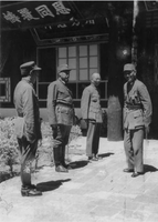 Chiang Kai-shek,leader ofNationalist China(right), meets with the Muslim generalsMa Bufang(second from left), andMa Buqing(first from left) inXining,Qinghai, in August 1942


Geography
[edit]Qinghai is located on the northeastern part of theTibetan Plateau.By area, it is the largest province in the People's Republic of China (excluding theautonomous regions).
TheYellow Riveroriginates in the southern part of the province, while theYangtzeandMekonghave their sources in the southwestern part. Qinghai is separated by theRiyue Mountaininto pastoral and agricultural zones in the west and east.[30]
TheSanjiangyuan National Nature Reserveis located in Qinghai and contains the headwaters of theYellow River,Yangtze River,andMekong River.The reserve was established to protect the headwaters of these three rivers and consists of 18 subareas, each containing three zones which are managed with differing degrees of strictness.
Qinghai Lakeis the largest salt water lake in China, and the second largest in the world. Other large lakes areLake Halain theQilian mountains,lakesGyaringandNgoringin the headwater region of the Yellow River,Lake Donggi Cona,and many saline andsalt lakesin the western part of the province.
TheQaidam basinlies in the northwest part of the province at an altitude between 3000 and 5000 meters above sea level. About a third of this resource rich basin is desert.
-
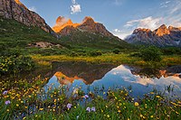 Nyenpo Yurtse,Jigzhi County,Qinghai
 -
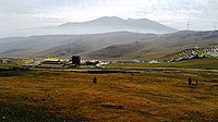 Riyue Mountainin Qinghai


Climate
[edit]This sectionrelies largely or entirely on asingle source.(December 2022) |

The average elevation of Qinghai is approximately 3000 m.[31]Mountain ranges include theTanggula MountainsandKunlun Mountains,with the highest point beingBukadaban Fengat 6860 m.[32]Due to the high altitude, Qinghai has quite cold winters (harsh in the highest elevations), mild summers, and a largediurnal temperature variation.[citation needed]Its mean annual temperature is approximately −5 to 8 °C (23 to 46 °F), with January temperatures ranging from −18 to −7 °C (0 to 19 °F) and July temperatures ranging from 15 to 21 °C (59 to 70 °F).[citation needed]It is also prone to heavy winds as well assandstormsfrom February to April. Significant rainfall occurs mainly in summer, while precipitation is very low in winter and spring, and is generally low enough to keep much of the provincesemi-aridorarid.[citation needed]
Politics
[edit]The Politics of Qinghai Province in thePeople's Republic of Chinaare structured in a one party-government system like all other governing institutions inmainland China.
The Governor of Qinghai ( thanh hải tỉnh tỉnh trường ) is the highest-ranking official in the People's Government of Qinghai. However, in the province's dual party-government governing system, the Governor has less power than the QinghaiChinese Communist Party Committee Secretary( thanh hải tỉnh ủy thư ký ), colloquially termed the "Qinghai Party Chief".
Administrative divisions
[edit]Because the Han form Qinghai's ethnic majority[30]and because none of its many ethnic minorities have clear dominance over the rest, the province is not administered as an autonomous region. Instead, the province has many ethnic autonomous areas at the district and county levels.[27]Qinghai is administratively divided into eightprefecture-level divisions:twoprefecture-level citiesand sixautonomous prefectures:
| Administrative divisions of Qinghai | ||||||||
|---|---|---|---|---|---|---|---|---|
| Division code[33] | Division | Area in km2[34] | Population 2010[35] | Seat | Divisions[36] | |||
| Districts | Counties | Aut. counties | CL cities | |||||
| 630000 | Qinghai Province | 720,000.00 | 5,626,723 | Xiningcity | 7 | 25 | 7 | 5 |
| 630100 | Xiningcity | 7,424.11 | 2,208,708 | Chengzhong District | 5 | 1 | 1 | |
| 630200 | Haidongcity | 13,043.99 | 1,396,845 | Ledu District | 2 | 4 | ||
| 632200 | Haibei Tibetan Autonomous Prefecture | 33,349.99 | 273,304 | Haiyan County | 3 | 1 | ||
| 632300 | Huangnan Tibetan Autonomous Prefecture | 17,908.89 | 256,716 | Tongrencity | 2 | 1 | 1 | |
| 632500 | Hainan Tibetan Autonomous Prefecture | 43,377.11 | 441,691 | Gonghe County | 5 | |||
| 632600 | Golog Tibetan Autonomous Prefecture | 76,442.38 | 181,682 | Maqên County | 6 | |||
| 632700 | Yushu Tibetan Autonomous Prefecture | 197,953.70 | 378,439 | Yushucity | 5 | 1 | ||
| 632800 | Haixi Mongol and Tibetan Autonomous Prefecture | 300,854.48 | 489,338 | Delinghacity | 3 | 3 | ||

| Administrative divisions in Chinese and varieties of romanizations | ||||
|---|---|---|---|---|
| English | Chinese | Pinyin | ||
| Qinghai Province | Thanh hải tỉnh | Qīnghǎi Shěng | ||
| Xiningcity | Tây ninh thị | Xīníng Shì | ||
| Haidongcity | Hải đông thị | Hǎidōng Shì | ||
| Haibei Tibetan Autonomous Prefecture | Hải bắc tàng tộc tự trị châu | Hǎiběi Zàngzú Zìzhìzhōu | ||
| Huangnan Tibetan Autonomous Prefecture | Hoàng nam tàng tộc tự trị châu | Huángnán Zàngzú Zìzhìzhōu | ||
| Hainan Tibetan Autonomous Prefecture | Hải nam tàng tộc tự trị châu | Hǎinán Zàngzú Zìzhìzhōu | ||
| Golog Tibetan Autonomous Prefecture | Quả lạc tàng tộc tự trị châu | Guǒluò Zàngzú Zìzhìzhōu | ||
| Yushu Tibetan Autonomous Prefecture | Ngọc thụ tàng tộc tự trị châu | Yùshù Zàngzú Zìzhìzhōu | ||
| Haixi Mongol and Tibetan Autonomous Prefecture | Hải tây mông cổ tộc tàng tộc tự trị châu | Hǎixī Měnggǔzú Zàngzú Zìzhìzhōu | ||
The eightprefecture-level divisionsof Qinghai are subdivided into 44county-level divisions(6districts,4county-level cities,27countiesand 7autonomous counties).
Urban areas
[edit]| Population by urban areas of prefecture & county cities | ||||
|---|---|---|---|---|
| # | Cities | 2020 Urban area[37] | 2010 Urban area[38] | 2020 City proper |
| 1 | Xining | 1,677,177 | 1,153,417 | 2,467,965 |
| 2 | Haidong | 204,784 | [b] | 1,358,471 |
| 3 | Golmud | 197,153 | 156,779 | part ofHaixi Prefecture |
| 4 | Yushu | 85,497 | [c] | part ofYushu Prefecture |
| 5 | Delingha | 65,424 | 54,844 | part ofHaixi Prefecture |
| (6) | Tongren | 49,962[d] | part ofHuangnan Prefecture | |
| 7 | Mangnai | 18,856 | [e] | part ofHaixi Prefecture |
- ^/tʃɪŋˈhaɪ/ching-HY;[5]Chinese:Thanh hải,IPA:[tɕʰíŋ.xàɪ];alternately romanizedasTsinghaiorChinghai)[6]
- ^Haidong Prefecture is currently known as Haidong PLC after 2010 census; Ledu County & Ping'an County is currently known asLedu&Ping'an(core districts of Haidong) after 2010 census.
- ^Yushu County is currently known as Yushu CLC after 2010 census.
- ^Tongren County is currently known as Tongren CLC after 2020 census.
- ^Mangnai Administrative Zone & Lenghu Administrative Zone County is currently known as Mangnai CLC after 2010 census.
Population
[edit]Demographics
[edit]| Year | Pop. | ±% |
|---|---|---|
| 1912[39] | 368,000 | — |
| 1928[40] | 619,000 | +68.2% |
| 1936–37[41] | 1,196,000 | +93.2% |
| 1947[42] | 1,308,000 | +9.4% |
| 1954[43] | 1,676,534 | +28.2% |
| 1964[44] | 2,145,604 | +28.0% |
| 1982[45] | 3,895,706 | +81.6% |
| 1990[46] | 4,456,946 | +14.4% |
| 2000[47] | 4,822,963 | +8.2% |
| 2010[48] | 5,626,722 | +16.7% |
| 2020 | 5,923,957 | +5.3% |
Ethnicity
[edit]There are over 37 recognized ethnic groups among Qinghai's population of 5.6 million, withHanpopulation standing at 50.5% of the total population andnational minoritiesmaking up 49.5% of the population.[49]In 2010,Tibetanpopulation stood at 20.7%,Hui16%,Tu(Monguor) 4%, with also some groups ofMongol,andSalar,all of those groups being the most populous in the province.Han Chinesepredominate in the cities ofXining,Haidong,DelinghaandGolmud,and elsewhere in the northeast. The Hui are concentrated in Xining, Haidong,Minhe County,Hualong County,andDatong County.TheTu peoplepredominate inHuzhu Countyand the Salars inXunhua County;Tibetans and Mongols are sparsely distributed across the rural western part of the province.[27]Of the Muslim ethnic groups in China, Qinghai has communities of Hui, Salar,Dongxiang,andBao'an.[16]The Hui dominate the wholesale business in Qinghai.[50]
Religion
[edit]Religion in Qinghai (2000s)

The predominant religions in Qinghai areChinese folk religions(includingTaoist traditionsandConfucianism) andChinese Buddhismamong theHan Chinese.The largeTibetanpopulation practicesTibetan schools of Buddhismor traditional Tibetan Bön religion, while theHui ChinesepracticeIslam.Christianityis the religion of 0.76% of the province's population according to the Chinese General Social Survey of 2004.[52]According to a survey of 2010, 17.51% of the population of Qinghai follow Islam.[51]
From September 1848, the city was the seat of a short-lived Latin CatholicApostolic Vicariate(pre-diocesan missionary jurisdiction) of Kokonur (alias Khouhkou-noor, Kokonoor), but it was suppressed in 1861. No incumbent(s) recorded.[53]
|


Culture
[edit]Qinghai has been influenced by interactions "between Mongol and Tibetan culture, north to south, and Han Chinese and Inner Asia Muslim culture, east to west".[27]The languages of Qinghai have for centuries formed aSprachbund,withZhongyuan Mandarin,Amdo Tibetan,Salar,Yugur,andMonguorborrowing from and influencing one another.[54]In mainstreamChinese culture,Qinghai is most associated with theTale of King Mu, Son of Heaven.[citation needed]According to this legend,King Mu of Zhou(r. 976–922 BCE) pursued hostileQuanrongnomads to eastern Qinghai, where the goddessXi Wangmuthrew the king a banquet in theKunlun Mountains.[55]
The main religions in Qinghai areTibetan Buddhism,IslamandChinese Folk Religions.TheDongguan Mosquehas been continuously operating since 1380.[23]: 402 Measures of education in Qinghai are low, particularly among the ethnic minorities.[27]Theyak,which is native to Qinghai, is widely used in the province for transportation and its meat.[30]The Mongols of Qinghai celebrate theNaadamfestival on theQaidam Basinevery year.[56]
Economy
[edit]
Qinghai's economy is amongst the smallest in China. Itsnominal GDPin 2022 was just RMB 361 billion (US$50 billion) and contributes to about 0.30% of the entire country's economy. Per capita GDP was RMB 60,724 (US$9,028) (nominal), the 24th in China.[57]
Its heavy industry includes iron and steel production, located near its capital city of Xining. Oil and natural gas from theQaidam Basinhave also been an important contributor to the economy.[58]Salt works operate at many of the province's numerous salt lakes.
Outside of the provincial capital, Xining, most of Qinghai remains underdeveloped. Qinghai ranks second lowest in China in terms of highway length, and will require a significant expansion of its infrastructure to capitalize on the economic potential of its rich natural resources.[58]
Economic and technological development zone
[edit]XiningEconomic & Technological Development Zone (XETDZ) was approved as state-level development zone in July 2000. It has a planned area of 4.4 km2.XETDZ lies in the east of Xining, 5 km from the city centre. Xining is located in the east of the province at the upper reaches of theHuangshui River,one of the Yellow River's branches. The city is surrounded by mountains with an average elevation of 2261 m, the highest at 4393 m. XETDZ is the first of its kind at the national level on the Qinghai-Tibet Plateau. It is established to fulfill the nation's strategy of developing the west.
XETDZ enjoys a convenient transportation system, connected by the Xining-Lanzhou expressway and running through by two main roads, the broadest in the city. It is 4 km from the railway station, 15 km from Xi'ning Airport—a grade 4D airport with 14 airlines to cities such as Beijing, Guangzhou, Shanghai, Chengdu and Xi'an. Xining is Qinghai province's passage to the outside world, a transportation hub with more than ten highways, over 100 roads and two railways, Lanzhou-Qinghai and Qinghai-Tibet Railways in and out of the city.
It focuses on the development of following industries: chemicals based on salt lake resources, nonferrous metals, and petroleum and natural gas processing; special medicine, foods and bio-chemicals using local plateau animals and plants; new products involving ecological and environmental protection, high technology, new materials as well as information technology; and services such as logistics, banking, real estate, tourism, hotel, catering, agency and international trade.[59]
Tourism
[edit]
Many tourist attractions center onXining,the provincial seat of Qinghai.
During the hot summer months, many tourists from the hot southern and eastern parts of China travel to Xining, as the climate of Xining in July and August is quite mild and comfortable, making the city an ideal summer retreat.
Qinghai Lake(Thanh hải hồ;qīnghǎi hú) is another tourist attraction, albeit further from Xining thanKumbum Monastery(Ta'er Si). The lake is the largest saltwater lake in China, and is also located on the "Roof of the World", the Tibetan Plateau. The lake itself lies at 3,600 m elevation. The surrounding area is made up of rollinggrasslandsand populated by ethnic Tibetans. Most pre-arranged tours stop at Bird Island (Điểu đảo;niǎo dǎo). An international bicycle race takes place annually from Xining to Qinghai Lake.
Transportation
[edit]
TheLanqing Railway,running betweenLanzhou,GansuandXining,the province's capital, was completed in 1959 and is the major transportation route in and out of the province. A continuation of the line, theQinghai-Tibet RailwayviaGolmudand western Qinghai, has become one of the most ambitious projects in PRC history. It was completed in October 2005 and now links Tibet with the rest of China through Qinghai.
Construction on theGolmud–Dunhuang Railway,in the province's northwestern part, started in 2012.
SixNational Highwaysrun through the province.
Xining Caojiabao International Airportprovides service toBeijing,Lanzhou,GolmudandDelingha.Smaller regional airports,Delingha Airport,Golog Maqin Airport,Huatugou Airport,Qilian AirportandYushu Batang Airport,serve the province's smaller communities; plans exist for the construction of three more by 2020.[60]
Telecommunications
[edit]Since theMinistry of Industry and Information Technologybegan its "Access to Telephones Project", Qinghai has invested 640 million yuan to providetelephoneaccess to 3860 out its 4133 administrative villages. At the end of 2006, 299 towns had receivedInternet access.However, 6.6 percent of villages in the region still have no access to the telephone. These villages are mainly scattered inQingnanArea, with 90 percent of them located inYushuandGuoluo.The average altitude of these areas exceeds 3600 meters, and the poor natural conditions hamper the establishment oftelecommunicationfacilities in the region.
Satellite phoneshave been provided to 186 remote villages in Qinghai Province as of September 14, 2007.[citation needed]The areas benefited were Yushu Tibetan Autonomous Prefecture and Guoluo Tibetan Autonomous Prefecture. Qinghai has recently been provided with satellite telephone access. In June 2007,China Satcomcarried out an in-depth survey in Yushu and Guoluo, and made a special satellite phones for these areas. Two phones were provided to each village for free, and calls were charged at the rate of 0.2 RMB (about a quarter of a US cent at that time) per minute for both local and national calls, with the extra charges assumed by China Satcom. No monthly rent was charged on the satellite phone. International calls were also available.
Colleges and universities
[edit]- Qinghai University(Thanh hải đại học)
- Qinghai Normal University(Thanh hải sư phạm đại học)
- Qinghai University for Nationalities(Thanh hải dân tộc đại học)
- Qinghai Medical College(Thanh hải y học viện)
- Qinghai Radio & Television University(Thanh hải quảng bá điện thị đại học)
See also
[edit]- 2010 Yushu earthquake
- Amdo
- Geladandong
- Haplogroup D-M15 (Y-DNA)
- Haplogroup O3 (Y-DNA)
- Iris qinghainica(native plant of Qinghai)
- Major national historical and cultural sites in Qinghai
- Tectonic summary of Qinghai
Notes
[edit]References
[edit]Citations
[edit]- ^"Qinghai Province".Qinghai Province Department of Commerce. Archived fromthe originalon 4 March 2016.Retrieved5 August2013.
- ^"Communiqué of the Seventh National Population Census (No. 3)".National Bureau of Statistics of China.11 May 2021.Retrieved11 May2021.
- ^"National Data".China NBS.March 2024.RetrievedJune 22,2024.see also"zh: 2023 niên thanh hải tỉnh quốc dân kinh tế hòa xã hội phát triển thống kế công báo".qinghai.gov.cn. February 29, 2024.RetrievedJune 22,2024.The average exchange rate of 2023 was CNY 7.0467 to 1 USD dollar"Statistical communiqué of the People's Republic of China on the 2023 national economic and social development"(Press release). China NBS. February 29, 2024.RetrievedJune 22,2024.
- ^"Subnational Human Development Index".Global Data Lab China. 2021.Retrieved9 April2020.
- ^"Qinghai".LexicoUK English Dictionary.Oxford University Press.Archived fromthe originalon May 18, 2021.
- ^Trung quốc địa danh lục(2nd ed.). Beijing: China Maps Press. 1995. p. 309.ISBN7-5031-1718-4.
- ^Gangchen Khishong, 2001.Tibet and Manchu: An Assessment of Tibet-Manchu Relations in Five Phases of Development.Dharmasala: Narthang Press, p.1-70.
- ^"Trung hoa dân quốc chính phủ lệnh".Quốc dân chính phủ công báo.Vol. 93. Republic of China: Quốc dân chính phủ bí thư xử. Sep 1928. p. 5.
- ^"Trung hoa dân quốc thập thất niên thập nguyệt thập cửu nhật trung hoa dân quốc chính phủ lệnh".Quốc dân chính phủ công báo.No. 2. Republic of China: Quốc dân chính phủ văn quan xử ấn chú cục. 27 Oct 1928. p. 9.
- ^"Trung hoa dân quốc thập bát niên nhất nguyệt nhị thập cửu nhật quốc dân chính phủ chỉ lệnh nhất bát cửu hào".Quốc dân chính phủ công báo.No. 80. Republic of China: Quốc dân chính phủ văn quan xử ấn chú cục. 31 Jan 1929. pp. 8–9.
- ^Purdue – Tibetan historyArchived2007-08-21 at theWayback Machine.
- ^Laurent Deshayes, 1997.Histoire du Tibet.Paris: Fayard.
- ^Gertraud Taenzer, 2012.The Dunhuang Region during Tibetan Rule (787-848).(Berlin): Harrassowitz Verlag.
- ^Leung 2007,p. 57.
- ^Smith, Warren W (2009).China's Tibet?: Autonomy or Assimilation.Rowman & Littlefield. pp. 24, 252.
- ^abBetta, Chiara (2004).The Other Middle Kingdom: A Brief History of Muslims in China.Indianapolis University Press. p. 21.
- ^William Ewart Gladstone, Baron Arthur Hamilton-Gordon Stanmore (1961).Gladstone-Gordon correspondence, 1851–1896: selections from the private correspondence of a British Prime Minister and a colonial Governor, Volume 51.American Philosophical Society. p. 27.ISBN9780871695147.Retrieved2010-06-28.
- ^William Ewart Gladstone, Baron Arthur Hamilton-Gordon Stanmore (1961).Gladstone-Gordon correspondence, 1851–1896: selections from the private correspondence of a British Prime Minister and a colonial Governor, Volume 51.American Philosophical Society. p. 27.ISBN9780871695147.Retrieved2010-06-28.
- ^The Times Atlas of World History.(Maplewood, New Jersey: Hammond, 1989) p. 175
- ^Louis M. J. Schram (2006).The Monguors of the Kansu-Tibetan Frontier: Their Origin, History, and Social Organization.Kessinger Publishing. p. 17.ISBN1-4286-5932-3.Retrieved2010-06-28.[permanent dead link]
- ^Graham Hutchings (2003).Modern China: a guide to a century of change(illustrated, reprint ed.). Harvard University Press. p. 351.ISBN0-674-01240-2.Retrieved2010-06-28.
- ^M.C. Goldstein (1994). Barnett and Akiner (ed.).Change, Conflict and Continuity among a community of nomadic pastoralists—A Case Study from western Tibet, 1950–1990., Resistance and Reform in Tibet.London: Hurst & Co.
- ^abcdCooke, Susette. "Surviving State and Society in Northwest China: The Hui Experience in Qinghai Province under the PRC."Journal of Muslim Minority Affairs28.3 (2008): 401–420.
- ^Henry George Wandesforde Woodhead, Henry Thurburn Montague Bell (1969).The China year book, Part 2.North China Daily News & Herald. p. 841.Retrieved2011-06-05.
- ^John Roderick (1993).Covering China: the story of an American reporter from revolutionary days to the Deng era.Imprint Publications. p. 104.ISBN1-879176-17-3.Retrieved2010-06-28.
- ^Felix Smith (1995).China pilot: flying for Chiang and Chennault.Brassey's. p. 140.ISBN1-57488-051-9.Retrieved2010-06-28.
- ^abcdeGoodman, David (2004).China's Campaign to "Open Up the West": National, Provincial, and Local Perspectives.Cambridge University Press. pp. 67–83.
- ^Werner Draguhn; David S. G. Goodman (2002).China's communist revolutions: fifty years of the People's Republic of China.Psychology Press. p. 38.ISBN0-7007-1630-0.Retrieved2011-04-09.
- ^Blondeau, Anne-Marie; Buffetrille, Katia (2008).Authenticating Tibet: Answers to China's 100 Questions.University of California Press. pp. 203–205.
It is often assumed that this current policy [of not politically uniting all ethnically Tibetan areas] reflects the PRC leadership's intention to divide and rule Tibet, but this assumption is not wholly accurate.... The PRC cemented the [historical] status quo by keeping Amdo/Qinghai as a separate, multinational province... China does not reverse perceived territorial acquisitions. Hence, all territories that escaped the domination of Lhasa in recent history remained attached to the neighboring Chinese constituencies they tended to be under the influence of.
- ^abcLahtinen, Anja (2009). "Maximising Opportunities for the Tibetans of Qinghai Province, China". In Cao, Huahua (ed.).Ethnic Minorities and Regional Development in Asia: Reality and Challenges.Amsterdam University Press. pp. 20–22.
- ^"Qinghai Province Mountains".
- ^Bukadaban Feng, Peakbagger.com
- ^Trung hoa nhân dân cộng hòa quốc huyện dĩ thượng hành chính khu hoa đại mã(in Simplified Chinese).Ministry of Civil Affairs.
- ^Shenzhen Statistical Bureau.《 thâm quyến thống kế niên giám 2014》(in Simplified Chinese).China Statistics Print.Archived fromthe originalon 2015-05-12.Retrieved2015-05-29.
- ^Census Office of the State Council of the People's Republic of China; Population and Employment Statistics Division of the National Bureau of Statistics of the People's Republic of China (2012).Trung quốc 2010 niên nhân khẩu phổ tra phân hương, trấn, nhai đạo tư liêu(1 ed.). Beijing:China Statistics Print.ISBN978-7-5037-6660-2.
- ^Ministry of Civil Affairs(August 2014).《 trung quốc dân chính thống kế niên giám 2014》(in Simplified Chinese).China Statistics Print.ISBN978-7-5037-7130-9.
- ^Quốc vụ viện nhân khẩu phổ tra bạn công thất, quốc gia thống kế cục nhân khẩu hòa xã hội khoa kỹ thống kế tư biên (2022).Trung quốc 2020 niên nhân khẩu phổ tra phân huyện tư liêu.Beijing:China Statistics Print.ISBN978-7-5037-9772-9.
- ^Quốc vụ viện nhân khẩu phổ tra bạn công thất, quốc gia thống kế cục nhân khẩu hòa xã hội khoa kỹ thống kế tư biên (2012).Trung quốc 2010 niên nhân khẩu phổ tra phân huyện tư liêu.Beijing:China Statistics Print.ISBN978-7-5037-6659-6.
- ^1912 niên trung quốc nhân khẩu.Retrieved6 March2014.
- ^1928 niên trung quốc nhân khẩu.Retrieved6 March2014.
- ^1936–37 niên trung quốc nhân khẩu.Retrieved6 March2014.
- ^1947 niên toàn quốc nhân khẩu.Retrieved6 March2014.
- ^Trung hoa nhân dân cộng hòa quốc quốc gia thống kế cục quan vu đệ nhất thứ toàn quốc nhân khẩu điều tra đăng ký kết quả đích công báo.National Bureau of Statistics of China.Archived fromthe originalon August 5, 2009.
- ^Đệ nhị thứ toàn quốc nhân khẩu phổ tra kết quả đích kỉ hạng chủ yếu thống kế sổ tự.National Bureau of Statistics of China.Archived fromthe originalon September 14, 2012.
- ^Trung hoa nhân dân cộng hòa quốc quốc gia thống kế cục quan vu nhất cửu bát nhị niên nhân khẩu phổ tra chủ yếu sổ tự đích công báo.National Bureau of Statistics of China.Archived fromthe originalon May 10, 2012.
- ^Trung hoa nhân dân cộng hòa quốc quốc gia thống kế cục quan vu nhất cửu cửu 〇 niên nhân khẩu phổ tra chủ yếu sổ cư đích công báo.National Bureau of Statistics of China.Archived fromthe originalon June 19, 2012.
- ^Hiện tương 2000 niên đệ ngũ thứ toàn quốc nhân khẩu phổ tra khoái tốc hối tổng đích nhân khẩu địa khu phân bố sổ cư công bố như hạ.National Bureau of Statistics of China.Archived fromthe originalon August 29, 2012.
- ^"Communiqué of the National Bureau of Statistics of People's Republic of China on Major Figures of the 2010 Population Census".National Bureau of Statistics of China.Archived fromthe originalon July 27, 2013.
- ^"How Much Does Beijing Control the Ethnic Makeup of Tibet?".ChinaFile.2021-09-02.Retrieved2023-05-08.
- ^"Demand for an aphrodisiac has brought unprecedented wealth to rural Tibet—and trouble in its wake".The Economist.19 December 2015.Retrieved20 December2015.
- ^abMin Junqing.The Present Situation and Characteristics of Contemporary Islam in China.JISMOR, 8.2010 Islam by province, page 29.Data from: Yang Zongde,Study on Current Muslim Population in China,Jinan Muslim, 2, 2010.
- ^abChina General Social Survey (CGSS) 2009. Report by:Xiuhua Wang (2015, p. 15)ArchivedSeptember 25, 2015, at theWayback Machine
- ^"Apostolic Vicariate of Kokonur, China".Archived fromthe originalon 2018-03-22.Retrieved2017-02-27.
- ^Janhunen, Juha(2006). "From Manchuria to Amdo Qinghai: On the Ethnic Implications of the Tuyuhun Migration".Tumen Jalafun Jecen Aku.Otto Harrassowitz Verlag. pp. 111–112.
- ^Asiapac Editorial (2006).Chinese History: Ancient China to 1911.Asiapac Books. p. 28.
- ^"Qaidam culture shines in Qinghai, NW China".Global Times.2009-07-21. Archived fromthe originalon 2016-03-04.Retrieved2013-06-05.
- ^"National Data".National Bureau of Statistics of China.1 March 2022.Retrieved23 March2022.
- ^ab"Qinghai Province: Economic News and Statistics for Qinghai's Economy".Archived fromthe originalon 2011-10-08.Retrieved2011-10-25.
- ^RightSite.asia|Xining Economic & Technological Development Zone
- ^"Qinghai to build 3 new airports before 2020".Archived fromthe originalon 2012-07-24.Retrieved2010-04-25.
General sources
[edit]External links
[edit]- Official website(in Chinese)
- Memorials from Qinghaifrom the 19th century.
Places adjacent to Qinghai | ||||||||||||||||
|---|---|---|---|---|---|---|---|---|---|---|---|---|---|---|---|---|
| ||||||||||||||||

| International | |
|---|---|
| National | |
| Geographic | |