
Ranfjorden
| Ranfjorden | |
|---|---|
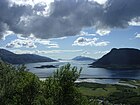
 View of the fjord | |
 Ranfjorden Location of the fjord  Ranfjorden Ranfjorden (Norway) | |
| Location | Nordlandcounty, Norway |
| Coordinates | 66°08′08″N12°50′32″E/ 66.1356°N 12.8422°E |
| Type | Fjord |
| Basincountries | Norway |
| Max. length | 68 kilometres (42 mi) |
| Max. depth | 525 metres (1,722 ft) |
Ranfjorden(in English alsothe Ranfjordor justRanfjord;[1]in Norwegian alsoRanafjorden,RanenorRana) is afjordin theHelgelanddistrict ofNordlandcounty,Norway.The largest part of the fjord is in the municipality ofRana,but the fjord also passes through the municipalities ofHemnes,Vefsn,Leirfjord,Nesna,andDønna.TheRanelvariver meets the Ranfjord in at the town ofMo i Ranaat the innermost part of the fjord. It then flows to the west for about 68 kilometres (42 mi) to where it meets the sea along the border ofDønnaandNesnamunicipalities.
The inner part of the fjord is lush, forested, and more heavily populated. The western parts of the fjord are narrow with steep sides and that area has few inhabitants. There is a narrowstraitthat connects to the Sørfjorden and Elsfjorden at the village ofHemnesberget.Two large rivers flow into the fjord:RanelvaandRøssåga.TheEuropean route E6highway follows the part of the southern coast of the fjord on its way toMo i Rana.[2]
Gallery
[edit]-
 The mouth of Ranfjorden nearNesna
 -
 Near Ytteren in Rana
 -
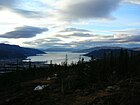 Kvitbergan, with Ranfjorden in the background
 -
 View between Båsmoen and Alteren in Rana
 -
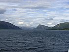 Eastward view into Ranfjorden
 -
 View from Ranfjorden of Moholmen, the oldest part of Mo i Rana.


References
[edit]- ^-enin the full name is a suffix meaning 'the' in Norwegian.
- ^Store norske leksikon."Ranfjorden"(in Norwegian).Retrieved2011-12-05.
ThisNordlandlocation article is astub.You can help Wikipedia byexpanding it. |