
Rayleigh, Essex
| Rayleigh | |
|---|---|
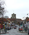
 Rayleigh High Street, as seen from the top of Holy Trinity Church in 2003 | |
 Rayleigh Location withinEssex | |
| Population | 32,150(2011)[1] |
| OS grid reference | TQ805907 |
| Civil parish |
|
| District | |
| Shire county | |
| Region | |
| Country | England |
| Sovereign state | United Kingdom |
| Post town | RAYLEIGH |
| Postcode district | SS6 |
| Dialling code | 01268 |
| Police | Essex |
| Fire | Essex |
| Ambulance | East of England |
| UK Parliament | |
Rayleigh/ˈreɪliː/is a market town andcivil parishin theRochford DistrictinEssex,England; it is located betweenChelmsfordandSouthend-on-Sea,32 miles (51 km) east of centralLondon.It had a population of 32,150 at the census in 2011.[1]
Toponymy
[edit]The nameRayleighisOld Englishin origin deriving fromrǣge('female roe-deer or she-goat') andlēah('clearing'). Therefore, the name means overall 'wood or clearing of the wild she-goats or roe-deer ".[3][4]
History
[edit]Prehistoric and Roman times
[edit]There has been a scattering of stray finds around the town from Prehistoric and Roman times, including some Roman roof andhypocausttiles found within the fabric of Rayleigh Church. This suggests that there was a Roman habitation site within the area. However, there is little evidence of any density of population here during this period.[5]
Saxon era
[edit]One significant archaeological find was in the early 2000s at the western edge of Rayleigh, at the site of the former Park School in Rawreth Lane. An early Saxon cemetery site was discovered here, with 144 cremation burials and evidence of just one high-status female inhumation burial.[6]
By the end of the Saxon period, there was definitely a village here, as it is recorded in theDomesday Bookof 1086 when it was held by Swein of Essex, the son ofRobert FitzWimarc.[7]
The most significant historic monument in Rayleigh is the great medieval mound ofRayleigh Castle.This was an early Normanmotte and baileycastle, of which only the motte and its surrounding embankments remain. Despite the loss of its timber superstructure and later stone buildings, its height and bulk mean that it still dominates the town centre.[8]
Later medieval period (1154–1485)
[edit]Acourthousewas erected in Rayleigh in 1338. This was apparently resented by the townspeople, who turned out in force to destroy it, with 20ringleaderslater arrested and tried.[9]
The forests around Rayleigh were royal hunting grounds. It is recorded thatKing Henry IIIhunted here in 1222, and three King Edwards also visited.[10]
One of the oldest secular buildings in Rayleigh is 91 High Street which houses Pizza Express downstairs andRayleigh Town Museumupstairs. The Regal Room in the museum is dated circa 1350. It is suspected that some of Rayleigh's older brick built buildings may contain portions older than this.[11]
Rayleigh Castle gradually fell into disuse, and in 1394King Richard IIgave permission for the townspeople of Rayleigh to use the foundations as a source of stone. By this time, the site was in royal ownership and used for pasture:
- know all men of special grace who have the will to repair certain Chapel in the said town and to build a new a certainbelfrywe have granted them the foundations and to take away and use any stones found therein ".[12]
Tudors and Stuarts
[edit]Records indicate that the church was rich in plate, vestments andstained glass,but these were disposed of:
- "No church within the hundred was more splendidly adorned; none were so richly furnished with plate, vestments and other accessories for the celebration of the divine service; none were so rich in painted glass; none have been more mercilessly despoiled"[13][14]
DuringHenry VIII's reign, deer were constantly taken from here to replenish the herds inGreenwich Park.[15]
Modern
[edit]
During the 1990s many new housing estates appeared on formerly greenfield areas of the town, with theEast of Englandregion currently pushing for even more homes to be built in the area. This has caused some controversy locally, with residents of Rayleigh feeling that the areas surrounding the town should be preserved with more care.[16]
Governance
[edit]There are three tiers of local government covering Rayleigh, atparish(town),districtandcountylevel: Rayleigh Town Council,Rochford District Council,andEssex County Council.
Rayleigh was anancient parish.When elected parish and district councils were created in 1894, it was given a parish council and included in theRochford Rural District.In 1929 Rayleigh and neighbouringRawrethwere removed from the Rochford Rural District and merged to become the Rayleigh Urban District, which was abolished in 1974 when the area became part of the District of Rochford.[17]
The constituency ofRayleigh and Wickfordis represented in theHouse of Commonsby the Member of ParliamentMark Francoisof theConservative Party.[18]
Rayleigh Town Council's responsibilities include:
- Consultee on Planning applications in Rayleigh.
- Christmas Lights and organisation of switch-on event in Town Centre, King George V Playing Field in Eastwood Road, floral displays in Town Centre and entry to AnnualAnglia in Bloomcompetition,CCTVin Town Centre, benches, salt bins, litter bins, bus shelters, some street lighting, heritage and memorial plaques, and the Town Centre clock.
- Four Allotment sites within Rayleigh with over 100 plots
- Consultee on crime & disorder reduction strategy within Rochford District Member of Rayleigh Windmill management committee.[19]
Rochford District Council's civic suite is located on Hockley Road.[20]The Citizens Advice Bureau and Registrar's Office are also located here.[21]The Civic Suite is a 19th century mansion house known as "Barringtons" which was converted for municipal use in 1953 and extended in 1964.[22]
Transport
[edit]Rayleigh railway stationis a stop on theShenfield-Southend line.Greater Angliaoperates services betweenSouthend VictoriaandLondon Liverpool Street.Three trains per hour run during the day in each direction; on Sundays, there are typically two trains per hour.[23]
Bus services are operated predominately byArriva SouthendandFirst Essex.Arriva's services focus on local routes, whereas First Essex services generally travel further afield. Services connect the town with Basildon,Chelmsford,Southend, Rochford, Hockley andStansted Airport.[24]
Education
[edit]
Rayleigh has two secondary schools:The Sweyne Park School,formed by the amalgamation of the Sweyne and Park schools, andFitzWimarc School.It also has seven primary schools – Down Hall, Edward Francis, Grove Wood, Our Lady of Ransom (Catholic), Rayleigh Primary and Wyburns. The seventh, Glebe Primary School with UHI, was created in September 2014 through the amalgamation of Glebe Infant and Nursery School and Glebe Junior School.[25]In addition, St Nicholas C of E Primary School, a long-established school for the adjoining village of Rawreth, moved in 2006 to a new building just on the Rayleigh side of the parish boundary.[26]
There are also two cadet units based in Rayleigh - Rayleigh Detachment EssexACFand 1476 (Rayleigh) SquadronRAFAC.
Sport and recreation
[edit]Rayleigh has a golf club on the outskirts of the town; Rayleigh Club (previously Lords Golf & Country Club) is situated on Hullbridge Road to the north of the town. This was originally opened in 1991 asHanover Golf Clubon the site of Hanover Farm and was designed by Reg Plumbridge.[27][28]
Parks/playing fields
[edit]Rayleigh has a number of parks and playing fields.
King George V playing field
[edit]The playing field is located next to Bull Lane, Hockley Road and Websters Way.[29]
It contains a snack bar and pavilion, as well as aTeenshelter
Its two grass football pitches are used by Rayleigh FC, Chronicles FC and Ralee FC. It also has a skate park[30]and a children's playground, containing a variety of play equipment. The park is also home to Rayleigh Bowls Club, who lease the use of the pavilion.
Rayleigh Lions holds an annual fireworks display on the playing field.[31]
Sweyne Park
[edit]
Sweyne Park is controlled by Rochford District Council. It is situated north of Sweyne Park School and can be accessed in several ways. The entrance in Downhall Park Way has a small car park and there is a play area. It has another smaller entrance in Downhall Park Way, adjacent to Canterbury Close; it can also be accessed from Victoria Avenue. In 2008, an entrance was established from Priory Chase. The park has a pond.[32]It has abridlewayrunning round its perimeter of about 2 km (1.2 mi).
- Fairview Playing Field, Victoria Road TQ814914
- Grove Playing Field, Grove Road TQ825904
- John Fisher Playing Field (Little Wheatleys Chase, Rayleigh) TQ789914
Kingley Wood stands on a steep hill slope beside the A127 and is visible when approaching Rayleigh from London. The small wood is the only surviving ancient wood in Rayleigh, but it has rich and variedwildlifeand a well-documented history.[33][34]
Wheatley Wood
[edit]This is a 64-acre (26 ha) broadleaved wood established in the late 1990s. The wood was designed and planted by a partnership of Local people and theWoodland Trust. There is a car park at the Grange Community Centre in Little Wheatley Chase and access to the wood is across the playing fields.[35]
Greyhounds and speedway
[edit]At least twogreyhound racingtracks existed in the town. The main venue was theRayleigh Weir Stadiumwhich also hostedspeedwayand traded from 1948-1974.[36]
A smaller short lived track at O'Tooles Meadow, Wickford Road, off the Down Hall Road also hosted greyhound racing and dirt track speedway. The racing was independent (not affiliated to the sports governing body theNational Greyhound Racing Club) and was known as a flapping track, which was the nickname given to independent tracks.[37]The track opened in 1932, but the date of closure is not known;[38]it is possible that it may have been the same venue known as the Rayleigh Sports Stadium, although it is also possible that the Rayleigh Sports Stadium may have been a third separate venue.[39]
Public facilities
[edit]

There is a small outdoor market on Wednesdays. Until 2011 it was located next to Rayleigh Civic Suite and Information Centre, opposite Holy Trinity Church. In 2011 it moved to the taxi rank in the town's High Street (outside Boots). The market dates back to before 1181 when it was inscribed in the Exchequer Records of Henry II.[40]
TheDutch Cottage,the smallest and oldest council house in the United Kingdom, can be visited on Wednesdays by prior appointment.[41]
Rayleigh Windmillhas been renovated, including a structural renovation of the 19th century brick built building has now been completed. The basic external brickwork has been repaired and the interior has been transformed to provide four storeys of modern display facilities which has turned the windmill into a major tourist and educational attraction in the county. The changes to the windmill allow the public to view the interior and to exploit this local historic amenity for cultural, educational and tourism use.[42]
Rayleigh Mount, a National Trust property adjacent to Rayleigh Windmill, is the site of a Domesday castle erected by Sweyn of Essex with distinctivemotte-and-baileydefences. Edward Belcham Francis gave the Mount to the National Trust in 1923.[43]From its summit it offers sweeping views across the Crouch Valley.[44]
Rayleigh Town Museum
[edit]Rayleigh Town Museumoccupies the 1st floor at 91 High Street and contains many artefacts telling the history of Rayleigh.[45]
Religion
[edit]
TheChurch of England parish churchof theHoly Trinityis at the top of the High Street.[46]A church existed on the site in Saxon times and the present building has aNormanchancel.Thebell towerwas built in the 15th century and includes stone taken from the castle when that fell into disuse. The church has an impressiveTudorbrick porch. TheGothic Revival architectC.C. Rolferestored the chancel in 1873.[47]
The parish church ofSaint Michaeland All Angels is in Sir Walter Raleigh Drive near Sweyne School. It was built in the 1950s when Rayleigh expanded considerably. It has a multi-purpose building which is used by other local groups as well as the church.[48]
Our Lady of Ransom Catholic Church is on London Hill.[49]
The United Reformed Church is on Crown Hill.[50]
The Baptist Church is in the High Street. The building opened for worship on 25 March 1799, shortly before the first Pastor, Rev James Pilkington, was inducted in June 1799. In June 1979, work started on a church extension. This added significantly more seating and completed some much needed repairs.[51]

The Methodist Church is on Eastwood Road. (Moved from the High Street in 1934).[52]
Grange Free Church is on London Road, at the junction with Langdon Road.[53]
The Salvation Army are located on the corner of the High Street and Love Lane. The building was the original 1884 Methodist Church, which was sold to the Salvation Army in 1934 when the Methodist Church moved to a larger site in Eastwood Road.[54]
Gallery
[edit]-
 Rayleigh High Street looking towards Holy Trinity Church.
 -
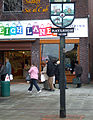 Rayleigh sign outside Rayleigh Lanes Indoor Market.
 -
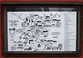 Map of Rayleigh Town Centre. Found on wall near the Millennium Clock.
 -
 Side of the Millennium Clock looking towards the Police Station.
 -
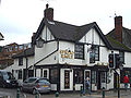
 Ye Olde Crown.
 -
 Spread Eagle.
 -
 Old White Horse.
 -
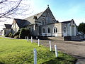 Rayleigh Methodist church from Eastwood Road.
 -
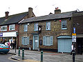
 91 High Street in Rayleigh.


References
[edit]- ^ab"Town population 2015".Neighbourhood Statistics.Office for National Statistics. Archived fromthe originalon 4 March 2016.Retrieved23 September2015.
- ^"Rayleigh Town Council – Rayleigh is a historic market town and is the main centre of population in the Rochford District".Rayleightowncouncil.gov.uk.Retrieved22 March2022.
- ^The Cambridge Dictionary of English Place Names,ed. by Victor Watts (Cambridge: Cambridge University Press, 2004).
- ^Rayleigh Civic Society 2006
- ^Historic Town Assessment Report for Rayleigh, 1999,pages 3 and 7.
- ^Essex County CouncilUnlocking Essex's Past.SMR Number 45134.
- ^"RAYLEIGH".OPEN DOMESDAY.Retrieved9 January2019.
- ^"The castle at Rayleigh Mount".National Trust.Retrieved9 January2019.
- ^Burrows 1909,p.31.
- ^Burrows 1909,p.27.
- ^"Rayleigh Historic Town Project Assessment Report"(PDF).Retrieved9 January2019.
- ^Rayleigh Civic Society 2006,Holy Trinity Church
- ^Burrows 1909,p.303.
- ^Burrows, John William (1909).Southend-on-Sea and district: historical notes.University of California Libraries. Southend-on-Sea: J.H. Burrows.
- ^Burrows 1909,pp. 28 58.
- ^Overwhelming objections to homes plan,2007, Southend Echo.
- ^"Rayleigh Ancient Parish / Civil Parish".A Vision of Britain through Time.GB Historical GIS / University of Portsmouth.Retrieved19 September2024.
- ^"Rt Hon Mark Francois MP,Parliament.uk, accessed 8 January 2018.
- ^"Rayleigh Town Council".Essexinfo.net.Retrieved13 August2011.
- ^"contact us".Rochford Council.Retrieved9 January2019.
- ^"our offices".CAB.Retrieved9 January2019.
- ^"Rayleigh Conservation Area Appraisal and Management Plan"(PDF).Rochford Council. p. 27.Retrieved8 February2021.
- ^"Timetables".Greater Anglia.2 June 2024.Retrieved6 September2024.
- ^"Stops in Rayleigh".Bustimes.org.Retrieved6 September2024.
- ^"Glebe Primary Prospectus".Retrieved30 October2014.
- ^"The history of our school | St Nicholas' Church of England Voluntary Controlled Primary School, Rawreth".St-nicholassch.co.uk. 11 September 2006.Retrieved22 March2022.
- ^"photo".Geograph.org.uk.Retrieved13 August2011.
- ^"Hanover Golf Club".englishgolfcourses.Retrieved18 February2021.
- ^"King George V Playing Field – Rayleigh Town Council".Rayleightowncouncil.gov.uk.Retrieved22 March2022.
- ^"King George V Playing Field page 7".Rayleigh Town Council.Retrieved10 January2019.
- ^"Rayleigh Lions Fireworks".
- ^"Sweyne Park Pond:: OS grid TQ7991:: Geograph Britain and Ireland – photograph every grid square!".Geograph.org.uk. 15 October 2007.Retrieved13 August2011.
- ^"Woodlands, Parks and Open Spaces | Kingley Woods".Rochford.gov.uk. Archived fromthe originalon 24 July 2011.
- ^"Kingley Wood photo".Geograph.org.uk.Retrieved13 August2011.
- ^"photo".Geograph.org.uk.Retrieved13 August2011.
- ^"OS Plan 1955".old-maps.co.uk.
- ^Barnes, Julia (1988).Daily Mirror Greyhound Fact File, page 419.Ringpress Books.ISBN0-948955-15-5.
- ^"Rayleigh O'Tooles".Greyhound Racing Times. 28 April 2019.
- ^"Rayleigh Sports Stadium".Greyhound Racing Times. 28 April 2019.
- ^"Rayleigh".Rochford District Council.Archived fromthe originalon 15 June 2011.Retrieved9 December2011.
- ^"Smallest council house for rent".BBC News. 14 July 2008.
- ^"Rayleigh Windmill".Rochford District Council.Archived fromthe originalon 19 August 2010.Retrieved9 December2011.
- ^"Edward Belcham Francis".
- ^ser (17 November 2005)."Rayleigh Mount".National Trust. Archived fromthe originalon 29 June 2011.Retrieved13 August2011.
- ^Drake, Kristina (4 February 2016)."Rayleigh historical museum to open in April".Echo.Retrieved14 April2020.
- ^"Parish of Rayleigh Website".Parishofrayleigh.org.uk.Retrieved13 August2011.
- ^Saint, 1970
- ^Our Lady of Ransom Catholic Church
- ^"Archived copy".Archived fromthe originalon 9 January 2019.Retrieved9 January2019.
{{cite web}}:CS1 maint: archived copy as title (link) - ^"Christ Church United Reformed Church, Rayleigh".Christchurchrayleigh.org.uk.Retrieved22 March2022.
- ^"Home".rayleighbaptist.org.uk.
- ^"Rayleigh Methodist church Website".rayleighmethodistchurch.org.uk.Retrieved21 February2013.
- ^"Grange Free Church | Rayleigh Churches".
- ^"Rayleigh".
Sources
[edit]- Burrows, John William. (1909).Southend on Sea and District: Historical Notes.ISBN0-85409-642-6.
- English Place-Name Society. (2008).The Survey of English Place-Names: Rayleigh.Institute for Name-Studies. Retrieved 2008-06-28.
- Essex County Council. (1999).Historic Town Assessment Report for Rayleigh.Retrieved 2008-06-28
- Percival, Geoff. (2007-06-05).work=Overwhelming objections to homes plan.Southend Echo. Retrieved 2008-06-28.
- Pevsner, Nikolaus(1965).The Buildings of England:Essex.Harmondsworth:Penguin Books.
- Rayleigh Civic Society. (2006).History of Rayleigh.Rayleigh Chamber of Trade and Commerce. Retrieved 2008-06-28.
- Rayleigh Civic Society. (2006).Holy Trinity Church.Rayleigh Chamber of Trade and Commerce. Retrieved 2008-06-28.
- Saint, Andrew (1970)."Three Oxford Architects".Oxoniensia.XXXV.Oxfordshire Architectural and Historical Society:53 ff. Archived fromthe originalon 28 September 2007.Retrieved3 November2009.
External links
[edit]- Rayleigh Town Museum
- Rayleigh Chamber of Trade- Section on Rayleigh's history
- National Trust – Rayleigh Mount
| International | |
|---|---|
| National | |
| Geographic | |