
Richwood, Ohio
Richwood, Ohio | |
|---|---|
 The Richwood Opera House | |
 Location of Richwood, Ohio | |
 Location of Richwood in Union County | |
| Coordinates:40°25′39″N83°17′42″W/ 40.42750°N 83.29500°W | |
| Country | United States |
| State | Ohio |
| County | Union |
| Township | Claibourne |
| Area | |
| • Total | 1.27 sq mi (3.28 km2) |
| • Land | 1.24 sq mi (3.22 km2) |
| • Water | 0.03 sq mi (0.07 km2) |
| Elevation | 948 ft (289 m) |
| Population (2020) | |
| • Total | 2,222 |
| • Density | 1,789.05/sq mi (690.88/km2) |
| Time zone | UTC-5(Eastern (EST)) |
| • Summer (DST) | UTC-4(EDT) |
| ZIP code | 43344 |
| Area code | 740 |
| FIPS code | 39-66936[3] |
| GNISfeature ID | 2399070[2] |
| Website | Village website |
Richwoodis avillageinUnion County,Ohio,United States. The population was 2,222 at the2020 census.
History[edit]
Early history, 1820–1860[edit]
Union Countywas organized on January 10, 1820, from territory previously contained inFranklin,Madison,LoganandDelawareCounties.[4]Claibourne Townshipwas surveyed by Richard Claiborne in 1811.[5]The first settler in Claiborne Township was Cyprian Lee, who with Henry Swartz took the contract to build the township's first road in 1825. The 15 feet (4.6 m) wide road was cut from the southernmost to the northernmost lines of the township, the effort consisting of clearing underbrush and small trees, leaving 'many obstacles in the shape of large timber.' This north to south road passed through what would become Richwood.
In 1832, two 1,200 acres (490 ha) land grants in Union County were received by William Pelham and Charles Blagrove of Virginia. Pelham sold his land to Blagrove that same year who promptly gave his nieces, Catherine and Parthenia Blagrove of Washington, D.C., the two parcels. Richwood would later be laid out on Parthenia's parcel. Blagrove put her legal affairs in the hands of Delaware attorney George Bomford, who sold the land to Philip Plummer.[5]
Philip Plummer was originally fromMt. Vernon,but he had been impressed with Union County's tree growth and rich soil.[6]Once he had purchased Blagrove'splathe returned with his brother Thomas, who was a surveyor. Together they found that the level ground and distance fromMarysville,the county seat, would make that location desirable for a city.[6]The town of Richwood was laid out August 8,9,10[7]1832 by Philip, his brother Thomas and Union County Surveyor Levi Phelps, who aided the project, and whose office recorded the first boundary lines for the new town.[8][5][6]
When the surveying was finished Richwood was platted and declared open for settlement, the plat covering a total area of 44 acres (18 ha).[6]The north-south and east-west roads were named Franklin (after Benjamin Franklin) and Ottaway (later renamed Ottawa), respectively, both to be 100 feet (30 m) wide.[6]Four other streets were platted: Fulton and Clinton Streets going north-south, Blagrove and Bomford going east-west, each to be 82.5 feet (25.1 m) wide.[6]
The first building in Richwood was a one-room log cabin occupied by John P. Brookins and his family.[7]For many years, he was the only doctor in Richwood and served as Justice of the Peace and as Postmaster.[6]
In 1834 Richwood got its first established business, a grocery store opened by Burdick & Calloway.[6]That same year, road work was completed, and all the roads going into the town were gravelled.[8]
TheMethodist Episcopal Churchwas formally organized on October 17, 1835, by Reverend William Frazell, who served as an itinerant minister.[5]
Richwood was incorporated as a village in March 1835,[6]and by 1840 twenty-five families were listed as living in Richwood.[6]As of 1877, the town contained one newspaper, two banks, three churches, one brick school-house, and several stores and factories.[8]
Geography[edit]
According to theUnited States Census Bureau,the village has a total area of 1.28 square miles (3.32 km2), of which 1.25 square miles (3.24 km2) is land and 0.03 square miles (0.08 km2) is water.[9]
Richwood is at the junction of Ohio State Routes37and47.
Demographics[edit]
| Census | Pop. | Note | %± |
|---|---|---|---|
| 1850 | 164 | — | |
| 1860 | 246 | 50.0% | |
| 1870 | 436 | 77.2% | |
| 1880 | 1,317 | 202.1% | |
| 1890 | 1,415 | 7.4% | |
| 1900 | 1,640 | 15.9% | |
| 1910 | 1,728 | 5.4% | |
| 1920 | 1,601 | −7.3% | |
| 1930 | 1,573 | −1.7% | |
| 1940 | 1,628 | 3.5% | |
| 1950 | 1,866 | 14.6% | |
| 1960 | 2,137 | 14.5% | |
| 1970 | 2,072 | −3.0% | |
| 1980 | 2,181 | 5.3% | |
| 1990 | 2,186 | 0.2% | |
| 2000 | 2,156 | −1.4% | |
| 2010 | 2,229 | 3.4% | |
| 2020 | 2,222 | −0.3% | |
| U.S. Decennial Census[10] | |||
2010 census[edit]
As of thecensus[11]of 2010, there were 2,229 people, 877 households, and 572 families residing in the village. Thepopulation densitywas 1,783.2 inhabitants per square mile (688.5/km2). There were 969 housing units at an average density of 775.2 per square mile (299.3/km2). The racial makeup of the village was 98.3%White,0.4%African American,0.2%Native American,0.1% fromother races,and 0.9% from two or more races.HispanicorLatinoof any race were 0.7% of the population.
There were 877 households, of which 40.6% had children under the age of 18 living with them, 45.7% weremarried couplesliving together, 13.3% had a female householder with no husband present, 6.2% had a male householder with no wife present, and 34.8% were non-families. 29.6% of all households were made up of individuals, and 14.1% had someone living alone who was 65 years of age or older. The average household size was 2.54 and the average family size was 3.14.
The median age in the village was 34.2 years. 29.6% of residents were under the age of 18; 7.5% were between the ages of 18 and 24; 28.2% were from 25 to 44; 22% were from 45 to 64; and 12.7% were 65 years of age or older. The gender makeup of the village was 47.4% male and 52.6% female.
2000 census[edit]
As of thecensus[3]of 2000, there were 2,156 people, 849 households, and 567 families residing in the village. The population density was 1,795.2 inhabitants per square mile (693.1/km2). There were 957 housing units at an average density of 796.9 per square mile (307.7/km2). The racial makeup of the village was 97.96%White,0.23%African American,0.14%Native American,0.09%Asian,0.19% fromother races,and 1.39% from two or more races.HispanicorLatinoof any race were 0.32% of the population.
There were 849 households, out of which 35.8% had children under the age of 18 living with them, 52.5% weremarried couplesliving together, 11.0% had a female householder with no husband present, and 33.1% were non-families. 28.2% of all households were made up of individuals, and 15.8% had someone living alone who was 65 years of age or older. The average household size was 2.54 and the average family size was 3.12.
In the village, the population was spread out, with 29.3% under the age of 18, 7.9% from 18 to 24, 29.3% from 25 to 44, 19.4% from 45 to 64, and 14.1% who were 65 years of age or older. The median age was 33 years. For every 100 females there were 90.1 males. For every 100 females age 18 and over, there were 87.6 males.
The median income for a household in the village was $39,550, and the median income for a family was $47,656. Males had a median income of $33,393 versus $21,971 for females. Theper capita incomefor the village was $16,799. About 6.6% of families and 8.4% of the population were below thepoverty line,including 9.0% of those under age 18 and 12.7% of those age 65 or over.
Education[edit]
Richwood is the home of theNorth Union Local School District.TheNorth Union High Schoolfootball team is known as the Wildcats.
Notable people[edit]
- Todd Gibson- Former American Indy Car Racer
- Martha Root- teacher of theBaháʼí Faith
- Wallace Clement Sabine- inventor of the modern-day science of architectural acoustics[12]
- Gary Shirk- Former Professional football player for the New York Giants
- John Marshall Hamilton(1847-1905),United States Senatorand 18thGovernor of Illinois(1883-1885) was born in Union County near Richwood.
Gallery[edit]
-
 June 7, 2010, N. Franklin St.
 -
 North Union High School, Richwood
 -
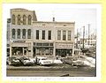
 28 Jan 1966, N. Franklin St.
 -
 28 Jan 1966, N. Franklin St.
 -
 28 Jan 1966, N. Franklin St.
 -
 28 Jan 1966, N. Franklin St.
 -
 28 Jan 1966, N. Franklin St.
 -
 Aerial photo of Richwood


References[edit]
- ^"ArcGIS REST Services Directory".United States Census Bureau.RetrievedSeptember 20,2022.
- ^abU.S. Geological Survey Geographic Names Information System: Richwood, Ohio
- ^ab"U.S. Census website".United States Census Bureau.RetrievedJanuary 31,2008.
- ^Vern Jackson, Ronald. "Ohio 1840 Census Index", Accelerated Indexing Systems, Inc., Bountiful, Utah, 1978. Print.
- ^abcdCarpe Diem Club. "History of Richwood Ohio 1832-1976", Carpe Diem Club, Richwood, 1976. Print.
- ^abcdefghijShearer Kennedy, Willella. "Our Heritage", Union County Historical Society, Marysville, 1963. Print.
- ^abCurry, W.L. History of Union County 1915.
- ^abcA.S. Mowry, C.E.,Atlas of Union County, Ohio,Harris, Sutton & Hare, Philadelphia, 1877, Pg. 19.
- ^"US Gazetteer files 2010".United States Census Bureau.Archived fromthe originalon January 12, 2012.RetrievedJanuary 6,2013.
- ^"Census of Population and Housing".Census.gov.RetrievedJune 4,2015.
- ^"U.S. Census website".United States Census Bureau.RetrievedJanuary 6,2013.
- ^Orcutt, William (1933).Wallace Clement Sabine: A Study of Achievement.Private Printing by The Plimpton Press. p. 10.
Municipalities and communities ofUnion County, Ohio,United States | ||
|---|---|---|
| Cities |  | |
| Villages | ||
| Townships | ||
| CDPs | ||
| Unincorporated communities | ||
| Ghost town | ||
| Footnotes | ‡This populated place also has portions in an adjacent county or counties | |
| International | |
|---|---|
| National | |