
River Thames
| River Thames | |
|---|---|
 The River Thames atVauxhall, London | |
 Course of the Thames | |
| Etymology | Proto-Celtic*tamēssa,possibly meaning "dark" |
| Location | |
| Country | England |
| Counties | Gloucestershire,Wiltshire,Oxfordshire,Berkshire,Buckinghamshire,Surrey,Greater London,Kent,Essex |
| Towns/cities | Cricklade,Lechlade,Oxford,Abingdon,Wallingford,Reading,Henley-on-Thames,Marlow,Maidenhead,Windsor,Staines-upon-Thames,Walton-on-Thames,Sunbury-on-Thames,Kingston upon Thames,London (inc.Twickenham,theCity),Dagenham,Erith,Dartford,Grays,Gravesend |
| Physical characteristics | |
| Source | |
| • location | Thames Head,Gloucestershire, UK |
| • coordinates | 51°41′40″N02°01′47″W/ 51.69444°N 2.02972°W |
| • elevation | 110 m (360 ft) |
| 2nd source | |
| • location | Ullenwood,Gloucestershire, UK |
| • coordinates | 51°50′49″N02°04′41″W/ 51.84694°N 2.07806°W |
| • elevation | 214 m (702 ft) |
| Mouth | Thames Estuary,North Sea |
• location | Southend-on-Sea,Essex, UK |
• coordinates | 51°30′00″N00°36′36″E/ 51.50000°N 0.61000°E |
• elevation | 0 m (0 ft) |
| Length | 346 km (215 mi) |
| Basin size | 12,935 km2(4,994 sq mi) |
| Discharge | |
| • location | London |
| • average | 65.8 m3/s (2,320 cu ft/s) |
| • maximum | 370 m3/s (13,000 cu ft/s) |
| Discharge | |
| • location | enteringOxford |
| • average | 17.6 m3/s (620 cu ft/s) |
| Discharge | |
| • location | leaving Oxford |
| • average | 24.8 m3/s (880 cu ft/s) |
| Discharge | |
| • location | Reading, Berkshire |
| • average | 39.7 m3/s (1,400 cu ft/s) |
| Discharge | |
| • location | Windsor |
| • average | 59.3 m3/s (2,090 cu ft/s) |
| Basin features | |
| Tributaries | |
| • left | Windrush,Cherwell,Colne,Lea,Roding |
| • right | Kennet,Wey,Mole |
Thameside settlements Towns/villages byparishbeside the river blank spaces indicate as place above ( ") | |||||||||||||||||||||||||||||||||||||||||||||||||||||||||||||||||||||||||||||||||||||||||||||||||||||||||||||||||||||||||||||||||||||||||||||||||||||||||||||||||||||||||||||||||||||||||||||||||||||||||||||||||||||||||||||||||||||||||||||||||||||||||||||||||||||||||||||||||||||||||||||||||||||||||||||||||||||||||||||||||||||||||||||||||||||||||||||||||||||||||||||||||||||||||||||||||||||||||||||||||||||||||||||||||||||||||||||||||||||||||||||||||||||||||||||||||||||||||||||||||||||||||||||||||||||||||||||||||||||||||||||||||||||||||||||||||||||||||||||||||||||||||||||||||||||||||||||||||||||||||||||||||||||||||||||||||||||||||||||||||||||||||||||||||||||||||||||||||||||||||||||||||||||||||||||||||||||||||||||||||||||||||||||||||||||||||||||||||||||||||||||||||||||||||||||||||||||||||||||||||||||||||||||||||||||||||||||||||||||||||||||||||||||||||||||||||||||||||||||||||||||||||||||||||||||||||||||||||||||||||||||||||||||||||||||||||||||||||||||||||||||||||||||||||||||||||||||||||||||||
|---|---|---|---|---|---|---|---|---|---|---|---|---|---|---|---|---|---|---|---|---|---|---|---|---|---|---|---|---|---|---|---|---|---|---|---|---|---|---|---|---|---|---|---|---|---|---|---|---|---|---|---|---|---|---|---|---|---|---|---|---|---|---|---|---|---|---|---|---|---|---|---|---|---|---|---|---|---|---|---|---|---|---|---|---|---|---|---|---|---|---|---|---|---|---|---|---|---|---|---|---|---|---|---|---|---|---|---|---|---|---|---|---|---|---|---|---|---|---|---|---|---|---|---|---|---|---|---|---|---|---|---|---|---|---|---|---|---|---|---|---|---|---|---|---|---|---|---|---|---|---|---|---|---|---|---|---|---|---|---|---|---|---|---|---|---|---|---|---|---|---|---|---|---|---|---|---|---|---|---|---|---|---|---|---|---|---|---|---|---|---|---|---|---|---|---|---|---|---|---|---|---|---|---|---|---|---|---|---|---|---|---|---|---|---|---|---|---|---|---|---|---|---|---|---|---|---|---|---|---|---|---|---|---|---|---|---|---|---|---|---|---|---|---|---|---|---|---|---|---|---|---|---|---|---|---|---|---|---|---|---|---|---|---|---|---|---|---|---|---|---|---|---|---|---|---|---|---|---|---|---|---|---|---|---|---|---|---|---|---|---|---|---|---|---|---|---|---|---|---|---|---|---|---|---|---|---|---|---|---|---|---|---|---|---|---|---|---|---|---|---|---|---|---|---|---|---|---|---|---|---|---|---|---|---|---|---|---|---|---|---|---|---|---|---|---|---|---|---|---|---|---|---|---|---|---|---|---|---|---|---|---|---|---|---|---|---|---|---|---|---|---|---|---|---|---|---|---|---|---|---|---|---|---|---|---|---|---|---|---|---|---|---|---|---|---|---|---|---|---|---|---|---|---|---|---|---|---|---|---|---|---|---|---|---|---|---|---|---|---|---|---|---|---|---|---|---|---|---|---|---|---|---|---|---|---|---|---|---|---|---|---|---|---|---|---|---|---|---|---|---|---|---|---|---|---|---|---|---|---|---|---|---|---|---|---|---|---|---|---|---|---|---|---|---|---|---|---|---|---|---|---|---|---|---|---|---|---|---|---|---|---|---|---|---|---|---|---|---|---|---|---|---|---|---|---|---|---|---|---|---|---|---|---|---|---|---|---|---|---|---|---|---|---|---|---|---|---|---|---|---|---|---|---|---|---|---|---|---|---|---|---|---|---|---|---|---|---|---|---|---|---|---|---|---|---|---|---|---|---|---|---|---|---|---|---|---|---|---|---|---|---|---|---|---|---|---|---|---|---|---|---|---|---|---|---|---|---|---|---|---|---|---|---|---|---|---|---|---|---|---|---|---|---|---|---|---|---|---|---|---|---|---|---|---|---|---|---|---|---|---|---|---|---|---|---|---|---|---|---|---|---|---|---|---|---|---|---|---|---|---|---|---|---|---|---|---|---|---|---|---|---|---|---|---|---|---|---|---|---|---|---|---|---|---|---|---|---|---|---|---|---|---|---|---|---|---|---|---|---|---|---|---|---|---|---|---|---|---|---|---|---|---|---|---|---|---|---|---|---|---|---|---|---|---|---|---|---|---|---|---|---|---|---|---|---|---|---|---|---|---|---|---|---|---|---|---|---|---|---|---|---|---|---|---|---|---|---|---|---|---|---|---|---|---|---|---|---|---|---|---|---|---|---|---|---|---|---|---|---|---|---|---|---|---|---|---|---|---|---|---|---|---|---|---|---|---|---|---|---|---|---|---|---|---|---|---|---|---|---|---|---|---|---|---|---|---|---|---|---|---|---|---|---|---|---|---|---|---|---|---|---|---|---|---|---|---|---|---|---|---|---|---|---|---|---|---|---|---|---|---|---|---|---|---|---|---|---|---|---|---|---|---|---|---|---|---|---|---|---|---|---|---|---|---|---|---|---|---|---|---|---|---|---|---|---|---|---|---|---|---|---|---|---|---|---|---|---|---|---|---|---|---|---|---|---|---|---|---|---|---|---|---|---|---|---|---|---|---|---|---|---|---|---|---|---|---|---|---|---|---|---|---|---|---|---|---|---|---|---|---|---|---|---|---|---|---|---|---|---|---|---|---|---|---|---|---|---|---|---|---|---|---|---|---|---|---|---|---|---|---|---|---|---|---|---|---|---|---|---|---|---|---|---|---|---|---|---|---|---|---|---|---|---|---|---|---|---|---|---|---|---|---|---|---|---|---|---|---|---|---|---|---|---|---|---|---|---|---|---|
| |||||||||||||||||||||||||||||||||||||||||||||||||||||||||||||||||||||||||||||||||||||||||||||||||||||||||||||||||||||||||||||||||||||||||||||||||||||||||||||||||||||||||||||||||||||||||||||||||||||||||||||||||||||||||||||||||||||||||||||||||||||||||||||||||||||||||||||||||||||||||||||||||||||||||||||||||||||||||||||||||||||||||||||||||||||||||||||||||||||||||||||||||||||||||||||||||||||||||||||||||||||||||||||||||||||||||||||||||||||||||||||||||||||||||||||||||||||||||||||||||||||||||||||||||||||||||||||||||||||||||||||||||||||||||||||||||||||||||||||||||||||||||||||||||||||||||||||||||||||||||||||||||||||||||||||||||||||||||||||||||||||||||||||||||||||||||||||||||||||||||||||||||||||||||||||||||||||||||||||||||||||||||||||||||||||||||||||||||||||||||||||||||||||||||||||||||||||||||||||||||||||||||||||||||||||||||||||||||||||||||||||||||||||||||||||||||||||||||||||||||||||||||||||||||||||||||||||||||||||||||||||||||||||||||||||||||||||||||||||||||||||||||||||||||||||||||||||||||||||||
Thames bridges | |||||||||||||||||||||||||||||||||||||||||||||||||||||||||||||||||||||||||||||||||||||||||||||||||||||||||||||||||||||||||||||||||||||||||||||||||||||||||||||||||||||||||||||||||||||||||||||||||||||||||||||||||||||||||||||||||||||||||||||||||||||||||||||||||||||||||||||||||||||||||||||||||||||||||||||||||||||||||||||||||||||||||||||||||||||||||||||||||||||||||||||||||||||||||||||||||||||||||||||||||||||||||||||||||||||||||||||||||||||||||||||||||||||||||||||||||||||||||||||||||||||||||||||||||||||||||||||||||||||||||||||||||||||||||||||||||||||||||||||||||||||||||||||||||||||||||||||||||||||||||||||||||||||||||||||||||||||||||||||||||||||||||||||||||||||||||||||||||||||||||||||||||||||||||||||||||||||||||||||||||||||||||||||||||||||||||||||||||||||||||||||||||||||||||||||||||||||||||||||||||||||||||||||||||||||||||||||||||||||||||||||||||||||||||||||||||||||||||||||||||||||||||||||||||||||||||||||||||||||||||||||||||||||||||||||||||||||||||||||||||||||||||||||||||||||||||||||||||||||||
|---|---|---|---|---|---|---|---|---|---|---|---|---|---|---|---|---|---|---|---|---|---|---|---|---|---|---|---|---|---|---|---|---|---|---|---|---|---|---|---|---|---|---|---|---|---|---|---|---|---|---|---|---|---|---|---|---|---|---|---|---|---|---|---|---|---|---|---|---|---|---|---|---|---|---|---|---|---|---|---|---|---|---|---|---|---|---|---|---|---|---|---|---|---|---|---|---|---|---|---|---|---|---|---|---|---|---|---|---|---|---|---|---|---|---|---|---|---|---|---|---|---|---|---|---|---|---|---|---|---|---|---|---|---|---|---|---|---|---|---|---|---|---|---|---|---|---|---|---|---|---|---|---|---|---|---|---|---|---|---|---|---|---|---|---|---|---|---|---|---|---|---|---|---|---|---|---|---|---|---|---|---|---|---|---|---|---|---|---|---|---|---|---|---|---|---|---|---|---|---|---|---|---|---|---|---|---|---|---|---|---|---|---|---|---|---|---|---|---|---|---|---|---|---|---|---|---|---|---|---|---|---|---|---|---|---|---|---|---|---|---|---|---|---|---|---|---|---|---|---|---|---|---|---|---|---|---|---|---|---|---|---|---|---|---|---|---|---|---|---|---|---|---|---|---|---|---|---|---|---|---|---|---|---|---|---|---|---|---|---|---|---|---|---|---|---|---|---|---|---|---|---|---|---|---|---|---|---|---|---|---|---|---|---|---|---|---|---|---|---|---|---|---|---|---|---|---|---|---|---|---|---|---|---|---|---|---|---|---|---|---|---|---|---|---|---|---|---|---|---|---|---|---|---|---|---|---|---|---|---|---|---|---|---|---|---|---|---|---|---|---|---|---|---|---|---|---|---|---|---|---|---|---|---|---|---|---|---|---|---|---|---|---|---|---|---|---|---|---|---|---|---|---|---|---|---|---|---|---|---|---|---|---|---|---|---|---|---|---|---|---|---|---|---|---|---|---|---|---|---|---|---|---|---|---|---|---|---|---|---|---|---|---|---|---|---|---|---|---|---|---|---|---|---|---|---|---|---|---|---|---|---|---|---|---|---|---|---|---|---|---|---|---|---|---|---|---|---|---|---|---|---|---|---|---|---|---|---|---|---|---|---|---|---|---|---|---|---|---|---|---|---|---|---|---|---|---|---|---|---|---|---|---|---|---|---|---|---|---|---|---|---|---|---|---|---|---|---|---|---|---|---|---|---|---|---|---|---|---|---|---|---|---|---|---|---|---|---|---|---|---|---|---|---|---|---|---|---|---|---|---|---|---|---|---|---|---|---|---|---|---|---|---|---|---|---|---|---|---|---|---|---|---|---|---|---|---|---|---|---|---|---|---|---|---|---|---|---|---|---|---|---|---|---|---|---|---|---|---|---|---|---|---|---|---|---|---|---|---|---|---|---|---|---|---|---|---|---|---|---|---|---|---|---|---|---|---|---|---|---|---|---|---|---|---|---|---|---|---|---|---|---|---|---|---|---|---|---|---|---|---|---|---|---|---|---|---|---|---|---|---|---|---|---|---|---|---|---|---|---|---|---|---|---|---|---|---|---|---|---|---|---|---|---|---|---|---|---|---|---|---|---|---|---|---|---|---|---|---|---|---|---|---|---|---|---|---|---|---|---|---|---|---|---|---|---|---|---|---|---|---|---|---|---|---|---|---|---|---|---|---|---|---|---|---|---|---|---|---|---|---|---|---|---|---|---|---|---|---|---|---|---|---|---|---|---|---|---|---|---|---|---|---|---|---|---|---|---|---|---|---|---|---|---|---|---|---|---|---|---|---|---|---|---|---|---|---|---|---|---|---|---|---|---|---|---|---|---|---|---|---|---|---|---|---|---|---|---|---|---|---|---|---|---|---|---|---|---|---|---|---|---|---|---|---|---|---|---|---|---|---|---|---|---|---|---|---|---|---|---|---|---|---|---|---|---|---|---|---|---|---|---|---|---|---|---|---|---|---|---|---|---|---|---|---|---|---|---|---|---|---|---|---|---|---|---|---|---|---|---|---|---|---|---|---|---|---|---|---|---|---|---|---|---|---|---|---|---|---|---|---|---|---|---|---|---|---|---|---|---|---|---|---|---|---|---|---|---|---|---|---|---|---|---|---|---|---|---|---|---|---|---|---|---|---|---|---|---|---|---|---|---|---|---|---|---|---|---|---|---|---|---|---|---|---|---|---|---|---|---|---|---|---|---|---|---|---|---|---|---|---|---|---|---|---|---|---|---|---|---|---|---|---|---|---|---|---|---|---|---|
| |||||||||||||||||||||||||||||||||||||||||||||||||||||||||||||||||||||||||||||||||||||||||||||||||||||||||||||||||||||||||||||||||||||||||||||||||||||||||||||||||||||||||||||||||||||||||||||||||||||||||||||||||||||||||||||||||||||||||||||||||||||||||||||||||||||||||||||||||||||||||||||||||||||||||||||||||||||||||||||||||||||||||||||||||||||||||||||||||||||||||||||||||||||||||||||||||||||||||||||||||||||||||||||||||||||||||||||||||||||||||||||||||||||||||||||||||||||||||||||||||||||||||||||||||||||||||||||||||||||||||||||||||||||||||||||||||||||||||||||||||||||||||||||||||||||||||||||||||||||||||||||||||||||||||||||||||||||||||||||||||||||||||||||||||||||||||||||||||||||||||||||||||||||||||||||||||||||||||||||||||||||||||||||||||||||||||||||||||||||||||||||||||||||||||||||||||||||||||||||||||||||||||||||||||||||||||||||||||||||||||||||||||||||||||||||||||||||||||||||||||||||||||||||||||||||||||||||||||||||||||||||||||||||||||||||||||||||||||||||||||||||||||||||||||||||||||||||||||||||||
TheRiver Thames(/tɛmz/TEMZ), known alternatively in parts as theRiver Isis,is a river that flows throughsouthern EnglandincludingLondon.At 215 miles (346 km), it is the longest river entirely in England and thesecond-longest in the United Kingdom,after theRiver Severn.
The river rises atThames HeadinGloucestershireand flows into theNorth SeanearTilbury,Essex andGravesend,Kent, via theThames Estuary.From the west, it flows throughOxford(where it is sometimes called the Isis),Reading,Henley-on-ThamesandWindsor.The Thames also drains the whole ofGreater London.[1]
The lowerreachesof the river are called theTideway,derived from its longtidalreach up toTeddington Lock.Its tidal section includes most of its London stretch and has a rise and fall of 23 ft (7 m). From Oxford to the estuary, the Thames drops by 55 metres (180 ft). Running through some of the drier parts of mainland Britain and heavily abstracted for drinking water, the Thames' discharge is low considering its length and breadth: the Severn has a discharge almost twice as large on average despite having a smallerdrainage basin.InScotland,theTayachieves more than double the Thames' average discharge from a drainage basin that is 60% smaller.
Along its course are 45navigation lockswith accompanyingweirs.Its catchment area covers a large part of south-eastern and a small part of western England; the river is fed by at least50 named tributaries.The rivercontains over 80 islands.With its waters varying from freshwater to almost seawater, the Thames supports a variety of wildlife and has a number of adjoiningSites of Special Scientific Interest,withthe largestbeing in theNorth Kent Marshesand covering 20.4 sq mi (5,289 ha).[2]
Name[edit]
Brittonic origin[edit]


According to Mallory and Adams, the Thames, fromMiddle EnglishTemese,is derived from theBrittonicname for the river,Tamesas(from *tamēssa),[3]recorded in Latin asTamesisand yielding modern WelshTafwys"Thames".
The name elementTammay have meant "dark" and can be compared to othercognatessuch as Russian темно (Proto-Slavic*tĭmĭnŭ),Lithuaniantamsi"dark",Latviantumsa"darkness",Sanskrittamasand Welshtywyll"darkness" andMiddle Irishteimen"dark grey".[3][b]The origin is shared by many other river names in Britain, such as theRiver Tamarat the border ofDevonandCornwall,severalrivers named Tameinthe MidlandsandNorth Yorkshire,theTavyonDartmoor,theTeamof the North East, theTeifiandTemeofWales,theTeviotin theScottish Bordersand a Thames tributary theThame.
Kenneth H. Jacksonproposed that the name of the Thames is notIndo-European(and of unknown meaning),[5]while Peter Kitson suggested that it is Indo-European but originated before theBritonsand has a name indicating "muddiness" from a root*tā-,'melt'.[6]
Name history[edit]
Early variants of the name include:
- Tamesa (Brittonic)[4]
- Tamesis (Latin)[4]
- Tamis, Temes (Old English)[4]
- Tamise, Thamis (1220) (Middle English,Anglo-Norman French)[c]
Indirect evidence for the antiquity of the name "Thames" is provided by a Romanpotsherdfound at Oxford, bearing the inscriptionTamesubugus fecit(Tamesubugus made [this]). It is believed that Tamesubugus' name was derived from that of the river.[7]Tamese was referred to as a place, not a river in theRavenna Cosmography(c. AD 700).
The river's name has always been pronounced with a simplet/t/; theMiddle Englishspelling was typicallyTemeseand the Brittonic formTamesis.A similar spelling from 1210, "Tamisiam" (the accusative case of "Tamisia"; seeKingston upon Thames § Early history), is found inMagna Carta.[8]

The Isis[edit]
The Thames throughOxfordis sometimes[when?]calledthe Isis.Historically, and especially inVictoriantimes, gazetteers and cartographers insisted that the entire river was correctly named the Isis from its source down toDorchester on Thamesand that only from this point, where the river meetsthe Thameand becomes the "Thame-isis" (supposedly subsequently abbreviated to Thames) should it be so called.[citation needed]Ordnance Surveymaps still label the Thames as "River Thames or Isis" down to Dorchester. Since the early 20th century this distinction has been lost in common usage outside of Oxford, and some historians[who?]suggest the nameIsisis nothing more than atruncationofTamesis,theLatinname for the Thames. Sculptures titledTamesisandIsisbyAnne Seymour Damerare located onthe bridgeatHenley-on-Thames,Oxfordshire(the original terracotta and plaster models were exhibited at theRoyal Academy,London,in 1785. They are now[when?]on show at theRiver and Rowing Museumin Henley).[9]
Name legacy[edit]
Richard Coatessuggests that while the river was as a whole called the Thames, part of it, where it was too wide to ford, was called *(p)lowonida.This gave the name to a settlement on its banks, which became known asLondinium,from the Indo-European roots *pleu-"flow" and *-nedi"river" meaning something like the flowing river or the wide flowing unfordable river.[10][11]
The river gives its name to three informal areas: theThames Valley,a region of England around the river between Oxford and West London; theThames Gateway;and the greatly overlappingThames Estuaryaround the tidal Thames to the east of London and including the waterway itself.Thames Valley Policeis a formal body that takes its name from the river, covering threecounties.In non-administrative use, the river's name is used in those ofThames Valley University,Thames Water,Thames Television,publishing companyThames & Hudson,Thameslink(north–south rail service passing throughcentral London) andSouth Thames College.An example of its use in the names of historic entities is theThames Ironworks and Shipbuilding Company.
History[edit]
Marks of human activity, in some cases dating back toPre-Roman Britain,are visible at various points along the river. These include a variety of structures connected with use of the river, such as navigations, bridges andwatermills,as well as prehistoricburial mounds.
The lower Thames in the Roman era was a shallow waterway winding through marshes. But centuries of human intervention havetransformed it into a deep tidal canalflowing between 200 miles of solid walls; these defend a floodplain where 1.5 million people work and live.
A major maritime route is formed for much of its length for shipping and supplies: through thePort of Londonfor international trade, internally along its length and by its connection to the British canal system. The river's position has put it at the centre of many events in British history, leading to it being described byJohn Burnsas "liquid history".
Two broadcanalslink the river to other rivers: theKennet and Avon Canal(ReadingtoBath) and theGrand Union Canal(London to the Midlands). The Grand Union effectively bypassed the earlier, narrow and windingOxford Canalwhich remains open as a popular scenic recreational route. Three further cross-basin canals are disused but are in various stages of reconstruction: theThames and Severn Canal(viaStroud), which operated until 1927 (to the west coast of England), theWey and Arun CanaltoLittlehampton,which operated until 1871 (to the south coast), and theWilts & Berks Canal.
Rowingand sailing clubs are common along the Thames, which is navigable to such vessels.Kayakingandcanoeingalso take place. Major annual events include theHenley Royal Regattaandthe Boat Race,while the Thames has been used during twoSummer Olympic Games:1908(rowing) and1948(rowingandcanoeing). Safe headwaters and reaches are a summer venue for organised swimming, which is prohibited on safety grounds in a stretch centred onCentral London.
Conversion of marshland[edit]
After the river took its present-day course, many of the banks of theThames Estuaryand theThames Valleyin London were partly covered inmarshland,as was the adjoiningLower Lea Valley.Streams and rivers like theRiver Lea,Tyburn BrookandBollo Brookdrained into the river, while some islands, e.g.Thorney Island,formed over the ages. The northern tip of the ancient parish ofLambeth,for example, was marshland known asLambeth Marshe,but it was drained in the 18th century; the street nameLower Marshpreserves a memory.[12]
Until the middle of the Victorian era, malaria was commonplace beside the River Thames, even in London, and was frequently lethal. Some cases continued to occur into the early 20th century. Draining of the marshes had to do with its eradication, but the causes are complex and unclear.
TheEast End of London,also known simply as theEast End,was the area of London east of the medieval walledCity of Londonand north of the River Thames, although it is not defined by universally accepted formal boundaries; theRiver Leacan be considered another boundary.[13]Most of the local riverside was also marshland. The land was drained and became farmland; it was built on after theIndustrial Revolution.
Canvey Islandin southern Essex (area 18.45 km2,7.12 sq mi; population 40,000[14]) was once marshy, but is now a fully reclaimed island in the Thames estuary, separated from the mainland of southEssexby a network of creeks. Lying below sea level, it is prone to flooding at exceptional tides, but has nevertheless been inhabited since Roman times.
Course[edit]


The usually quotedsourceof the Thames is atThames Head(atgrid referenceST980994). This is about 1.5 mi (2.4 km)[15]north of the village ofKemblein southernGloucestershire,near the town ofCirencester,in theCotswolds.[16]However,Seven SpringsnearCheltenham,where theChurn(which feeds into the Thames nearCricklade) rises, is also sometimes quoted as the Thames' source,[17][18]as this location is farthest from the mouth and adds some 14 mi (23 km) to the river's length. At Seven Springs above the source is a stone with the Latinhexameterinscription "Hic tuus o Tamesine pater septemgeminus fons", which means "Here, O Father Thames, [is] your sevenfold source".[19]
Thespringsat Seven Springs flow throughout the year, while those at Thames Head are seasonal (awinterbourne). With a length of 215 mi (346 km),[20]the Thames is the longest river entirely in England. (Thelongest riverin the United Kingdom, theSevern,flows partly inWales.) However, as the River Churn, sourced at Seven Springs, is 14 mi (23 km) longer than the section of the Thames from its traditional source at Thames Head to the confluence, the overall length of the Thames measured from Seven Springs, at 229 mi (369 km), is greater than the Severn's length of 220 mi (350 km).[21]Thus, the "Churn/Thames" river may be regarded as the longest natural river in the United Kingdom. The stream from Seven Springs is joined atCoberleyby a longer tributary which could further increase the length of the Thames, with its source in the grounds of theNational Star CollegeatUllenwood.
The Thames flows through or alongsideAshton Keynes,Cricklade,Lechlade,Oxford,Abingdon-on-Thames,Wallingford,Goring-on-ThamesandStreatley(at theGoring Gap),PangbourneandWhitchurch-on-Thames,Reading,Wargrave,Henley-on-Thames,Marlow,Maidenhead,WindsorandEton,Staines-upon-ThamesandEgham,Chertsey,Shepperton,Weybridge,Sunbury-on-Thames,Walton-on-Thames,MoleseyandThames Ditton.The river was subject to minor redefining and widening of the main channel around Oxford, Abingdon and Marlow before 1850, when further cuts to ease navigation reduced distances further.
MoleseyfacesHampton,and inGreater Londonthe Thames passesHampton Court Palace,Surbiton,Kingston upon Thames,Teddington,Twickenham,Richmond(with a famous view of the Thames from Richmond Hill),Syon House,Kew,Brentford,Chiswick,Barnes,Hammersmith,Fulham,Putney,Wandsworth,BatterseaandChelsea.Incentral London,the river passesPimlicoandVauxhall,and then forms one of the principal axes of the city, from thePalace of Westminsterto theTower of London.At this point, it historically formed the southern boundary of the medieval city, withSouthwark,on the opposite bank, then being part ofSurrey.
Beyond central London, the river passesBermondsey,Wapping,Shadwell,Limehouse,Rotherhithe,Millwall,Deptford,Greenwich,Cubitt Town,Blackwall,New CharltonandSilvertown,before flowing through theThames Barrier,which protects central London from flooding bystorm surges.Below the barrier, the river passesWoolwich,Thamesmead,Dagenham,Erith,Purfleet,Dartford,West Thurrock,Northfleet,TilburyandGravesendbefore entering theThames EstuarynearSouthend-on-Sea.
Sea level[edit]
The sea level in the Thames estuary is rising and the rate of rise is increasing.[22][23]
Sediment cores up to 10 m deep collected by theBritish Geological Surveyfrom the banks of the tidal River Thames contain geochemical information and fossils which provide a 10,000-year record of sea-level change.[24]Combined, this and other studies suggest that the Thames sea-level has risen more than 30 m during the Holocene at a rate of around 5–6 mm per year from 10,000 to 6,000 years ago.[24]The rise of sea level dramatically reduced when the ice melt nearly concluded[clarification needed]over the past 4,000 years. Since the beginning of the 20th century, rates of sea level rise range from 1.22 mm per year to 2.14 mm per year.[24]
Catchment area and discharge[edit]
The Thames River Basin[25]District, including the Medway catchment, covers an area of 6,229 sq mi (16,130 km2).[26]The entire river basin is a mixture of urban and rural, with rural landscape predominating in the western part. The area is among the driest in the United Kingdom. Water resources consist ofgroundwaterfromaquifersand water taken from the Thames and its tributaries, much of it stored in largebank-side reservoirs.[26]
The Thames itself provides two-thirds of London's drinking water, while groundwater supplies about 40 per cent of public water supplies in the overall catchment area. Groundwater is an important water source, especially in the drier months, so maintaining its quality and quantity is extremely important. Groundwater is vulnerable to surface pollution, especially in highly urbanised areas.[26]
Non-tidal section[edit]


Brooks, canals and rivers, within an area of 3,842 sq mi (9,951 km2),[27]combine to form 38 main tributaries feeding the Thames between its source andTeddington Lock.This is the usualtidal limit;however, high spring tides can raise the head water level in the reach above Teddington and can occasionally reverse the river flow for a short time. In these circumstances, tidal effects can be observed upstream to the next lock besideMolesey weir,[27]which is visible from the towpath andbridgebesideHampton Court Palace.Before Teddington Lock was built in 1810–12, the river was tidal at peak spring tides as far asStaines upon Thames.
In descending order, non-related tributaries of the non-tidal Thames, with river status, are theChurn,Leach,Cole,Ray,Coln,Windrush,Evenlode,Cherwell,Ock,Thame,Pang,Kennet,Loddon,Colne,WeyandMole.In addition, there are occasional backwaters and artificial cuts that form islands,distributaries(most numerous in the case of theColne), and man-made distributaries such as theLongford River.Three canals intersect this stretch: theOxford Canal,Kennet and Avon CanalandWey Navigation.
Its longest artificial secondary channel (cut), theJubilee River,was built between Maidenhead and Windsor for flood relief and completed in 2002.[28][29]
The non-tidal section of the river is managed by theEnvironment Agency,which is responsible for managing the flow of water to help prevent and mitigate flooding, and providing for navigation: the volume and speed of water downstream is managed by adjusting the sluices at each of the weirs and, at peak high water, levels are generally dissipated over preferred flood plains adjacent to the river. Occasionally, flooding of inhabited areas is unavoidable and the agency issues flood warnings. Due to stiff penalties applicable on the non-tidal river, which is a drinking water source before treatment,sanitary sewer overflowfrom the manysewage treatment plantscovering the upper Thames basin should be rare in the non-tidal Thames. However, storm sewage overflows are still common in almost all the main tributaries of the Thames[30][31]despite claims by Thames Water to the contrary.[32]
Tidal section[edit]


Below Teddington Lock (about 55 mi or 89 km upstream of the Thames Estuary), the river is subject totidal activityfrom theNorth Sea.Before the lock was installed, the river was tidal as far as Staines, about 16 mi (26 km) upstream.[33]London, capital ofRoman Britain,was established on two hills, now known asCornhillandLudgate Hill.These provided a firm base for a trading centre at the lowest possible point on the Thames.[34]
A river crossing was built at the site ofLondon Bridge.London Bridge is now used as the basis for published tide tables giving the times ofhigh tide.High tide reaches Putney about 30 minutes later than London Bridge, and Teddington about an hour later. Thetidal stretchof the river is known as "theTideway".Tide tables are published by thePort of London Authorityand are available online. Times of high and low tides are also posted on Twitter.
The principaltributaries of the River Thameson the Tideway include the riversCrane,Brent,Wandle,Ravensbourne(the final part of which is calledDeptford Creek),Lea(the final part of which is calledBow Creek),Roding(Barking Creek),DarentandIngrebourne.In London, the water is slightlybrackishwith sea salt, being a mix of sea and fresh water.

This part of the river is managed by thePort of London Authority.The flood threat here comes from high tides and strong winds from the North Sea, and the Thames Barrier was built in the 1980s to protect London from this risk.
The Noreis thesandbankthat marks the mouth of theThames Estuary,where the outflow from the Thames meets theNorth Sea.It is roughly halfway betweenHavengore Creekin Essex and Warden Point on theIsle of Sheppeyin Kent. Until 1964 it marked the seaward limit of the Port of London Authority. As the sandbank was a major hazard for shipping coming in and out of London, in 1732 it received the world's firstlightship.This became a major landmark, and was used as an assembly point for shipping. Today it is marked by Sea Reach No. 1 Buoy.[35]
Islands[edit]

The River Thames contains over 80 islands ranging from the large estuarial marshlands of theIsle of SheppeyandCanvey Islandto small tree-covered islets likeRose Islein Oxfordshire andHeadpile Eyotin Berkshire. They are found all the way fromFiddler's Islandin Oxfordshire to theIsle of Sheppeyin Kent. Some of the largest inland islands, for exampleFormosa Islandnear Cookham andAndersey Islandat Abingdon, were created naturally when the course of the river divided into separate streams.
In the Oxford area the river splits into several streams across thefloodplain(Seacourt Stream,Castle Mill Stream,Bulstake Streamand others), creating several islands (Fiddler's Island,Osneyand others).Desborough Island,Ham Islandat Old Windsor andPenton Hook Islandwere artificially created by lock cuts and navigation channels.Chiswick Eyotis a landmark on the Boat Race course, whileGlover's Islandforms the centre of a view fromRichmond Hill.
Islands of historical interest includeMagna Carta IslandatRunnymede,Fry's Islandat Reading, andPharaoh's Islandnear Shepperton. In more recent timesPlatts EyotatHamptonwas the place whereMotor Torpedo Boats(MTB)s were built,Tagg's Islandnear Molesey was associated with the impresarioFred KarnoandEel Pie Islandat Twickenham was the birthplace of the South East'sR&Bmusic scene.
Westminster Abbeyand thePalace of Westminster(commonly known today as theHouses of Parliament) were built onThorney Island,which used to be aneyot.
Geology[edit]

Researchers have identified the River Thames as a discrete drainage line flowing as early as 58 million years ago, in theThanetianstage of the latePalaeoceneepoch.[36]Until around 500,000 years ago, the Thames flowed on its existing course through what is nowOxfordshire,before turning to the north-east throughHertfordshireandEast Angliaand reaching theNorth Seanear present-dayIpswich.[37]
At this time the river-system headwaters lay in the EnglishWest Midlandsand may, at times, have received drainage from theBerwyn MountainsinNorth Wales.
Ice age[edit]
About 450,000 years ago, in the most extremeIce Ageof thePleistocene,theAnglian,the furthest southern extent of the ice sheet reachedHornchurch[38]in east London, the Vale of St Albans, and theFinchley Gap.
It dammed the river inHertfordshire,resulting in the formation of large ice lakes, which eventually burst their banks and caused the river to divert onto its present course through the area of present-day London.
The ice lobe which stopped at present-dayFinchleydeposited about 14 metres ofboulder claythere.[39]Its torrent ofmeltwatergushed through theFinchley Gapand south towards the new course of the Thames, and proceeded to carve out theBrent Valleyin the process.[40]
The Anglian ice advance resulted in a new course for the Thames throughBerkshireand on into London, after which the river rejoined its original course in southernEssex,near the presentRiver Blackwaterestuary. Here it entered a substantial freshwater lake in the southern North Sea basin, south of what is calledDoggerland.The overspill of this lake caused the formation of theChannel Riverand later theDover Straitgap between present-dayBritainand France. Subsequent development led to the continuation of the course that the river follows at the present day.[41]
Most of thebedrockof theVale of Aylesburycomprisesclayandchalkthat formed at the end of theice ageand at one time was under theProto-Thames.At this time the vast underground reserves of water formed that make thewater tablehigher than average in the Vale of Aylesbury.[42]


At the height of thelast ice age,around 20,000 BC, Britain was connected to mainland Europe by a large expanse of land known asDoggerlandin the southernNorth Sea Basin.At this time, the Thames' course did not continue to Doggerland but flowed southwards from the eastern Essex coast where it met the waters of the proto-Rhine–Meuse–Scheldt delta[41]flowing from what are now theNetherlandsandBelgium.These rivers formed a single river – theChannel River(Fleuve Manche) – that passed through the Dover Strait and drained into the Atlantic Ocean in the westernEnglish Channel.
Upon the valley sides of the Thames and some of its tributaries can be seen other terraces ofbrickearth,laid over and sometimes interlayered with the clays. These deposits were brought in by the winds during theperiglacialperiods, suggesting that wide, flat marshes were then part of the landscape, which the new rivers proceeded to cut into.
The steepness of some valley sides indicates very much lowermean sea levelscaused by the glaciation locking up so much water upon the land masses, thus causing the river water to flow rapidly seaward and so erode its bed quickly downwards.
The original land surface was around 350 to 400 ft (110 to 120 m) above the current sea-level. The surface had sandy deposits from an ancient sea, laid over sedimentary clay (this is the blueLondon Clay). All the erosion down from this higher land surface, and the sorting action by these changes of water flow and direction, formed what is known as the ThamesRiver Gravel Terraces.
Since Roman times and perhaps earlier, theisostaticrebound from the weight of previous ice sheets, and its interplay with theeustaticchange in sea level, have resulted in the old valley of the River Brent, together with that of the Thames, silting up again. Thus, along much of the Brent's present-day course, one can make out thewater-meadowsof rich alluvium, which is augmented by frequent floods.
Wildlife[edit]

Various species of birds feed off the river or nest on it, some being found both at sea and inland. These includecormorant,black-headed gullandherring gull.Themute swanis a familiar sight on the river but the escapedblack swanis more rare. The annual ceremony ofSwan Uppingis an old tradition of counting stocks.
Non-native geese that can be seen includeCanada geese,Egyptian geeseandbar-headed geese,and ducks include the familiar nativemallard,plus introducedMandarin duckandwood duck.Other water birds to be found on the Thames include thegreat crested grebe,coot,moorhen,heronandkingfisher.Many types of British birds also live alongside the river, although they are not specific to the river habitat.
The Thames contains both sea water and fresh water, thus providing support for seawater and freshwater fish. However, many populations of fish are at risk and are being killed in tens of thousands because of pollutants leaking into the river from human activities.[43]Salmon,which inhabit both environments, have been reintroduced and a succession offish laddershave been built intoweirsto enable them to travel upstream.
On 5 August 1993, the largest non-tidal salmon in recorded history was caught close toBoulters LockinMaidenhead.The specimen weighed14+1⁄2lb (6.6 kg) and measured 22 in (56 cm) in length. Theeelis particularly associated with the Thames and there were formerly many eel traps. Freshwater fish of the Thames and its tributaries includebrown trout,chub,dace,roach,barbel,perch,pike,bleakandflounder.Colonies ofshort-snouted seahorsesas well astopeandstarry smooth-hound sharkshave also recently been discovered in the river.[44][45]The Thames is also host to some invasive crustaceans, including thesignal crayfishand theChinese mitten crab.
Aquatic mammals are also known to inhabit the Thames. The population ofgreyandharbour sealsnumbers up to 700 in the Thames Estuary. These animals have been sighted as far upriver as Richmond.[46]Bottlenose dolphinsandharbour porpoisesare also sighted in the Thames.[47]
On 20 January 2006, a 16–18 ft (4.9–5.5 m) northernbottle-nosed whalewas seen in the Thames as far upstream as Chelsea. This was extremely unusual: this whale is generally found in deep sea waters. Crowds gathered along the riverbanks to witness the spectacle but there was soon concern, as the animal came within yards of the banks, almost beaching, and crashed into an empty boat causing slight bleeding. About 12 hours later, the whale is believed to have been seen again nearGreenwich,possibly heading back to sea. A rescue attempt lasted several hours, but the whale died on a barge.SeeRiver Thames whale.[48]
Human history[edit]

The River Thames has played several roles in human history: as an economic resource, a maritime route, a boundary, a fresh water source, a source of food and more recently a leisure facility. In 1929,John Burns,one-time MP for Battersea, responded to an American's unfavourable comparison of the Thames with theMississippiby coining the expression "The Thames is liquid history".
There is evidence of human habitation living off the river along its length dating back toNeolithictimes.[49]TheBritish Museumhas a decorated bowl (3300–2700 BC), found in the river atHedsor,Buckinghamshire, and a considerable amount of material was discovered during the excavations ofDorney Lake.[50]A number ofBronze Agesites and artefacts have been discovered along the banks of the river including settlements atLechlade,CookhamandSunbury-on-Thames.[51]
So extensive have the changes to this landscape been that what little evidence there is of man's presence before the ice came has inevitably shown signs of transportation here by water and reveals nothing specifically local. Likewise, later evidence of occupation, even since the arrival of the Romans, may lie next to the original banks of the Brent but have been buried under centuries of silt.[51]
Roman Britain[edit]
Some of the earliest written references to the Thames (Latin:Tamesis) occur inJulius Caesar's account of his second expedition to Britain in 54 BC,[52]when the Thames presented a major obstacle and he encountered theIron AgeBelgictribes (CatuvellauniandAtrebates) along the river. At the confluence of the Thames and Cherwell was the site of early settlements and the River Cherwell marked the boundary between theDobunnitribe to the west and the Catuvellauni to the east (these were pre-RomanCeltictribes). In the late 1980s a largeRomano-Britishsettlement was excavated on the edge of the village ofAshton Keynesin Wiltshire.
Starting in AD 43, under theEmperor Claudius,theRomans occupied Englandand, recognising the river's strategic and economic importance, built fortifications along the Thames valley includinga major campatDorchester.CornhillandLudgate Hillprovided a defensible site near a point on the river both deep enough for the era's ships and narrow enough to be bridged;Londinium(London) grew up around theWalbrookon the north bank around the year 47.Boudica'sIcenirazed the settlement in AD 60 or 61, but it was soon rebuilt; and once the bridge was built, it grew to become the provincial capital of the island.
The next Roman bridges upstream were atStaineson theDevil's Highwaybetween Londinium andCalleva(Silchester). Boats could be swept up to it on the rising tide, with no need for wind or muscle power.
Middle Ages[edit]
A Romano-British settlement grew up north of the confluence, partly because the site was naturally protected from attack on the east side by theRiver Cherwelland on the west by the River Thames. This settlement dominated the pottery trade in what is now central southern England, and pottery was distributed by boats on the Thames and its tributaries.
Competition for the use of the river created the centuries-old conflict between those who wanted to dam the river to build millraces and fish traps and those who wanted to travel and carry goods on it. Economic prosperity and the foundation of wealthy monasteries by theAnglo-Saxonsattracted unwelcome visitors and by around AD 870 theVikingswere sweeping up the Thames on the tide and creating havoc as in their destruction ofChertsey Abbey.

OnceKing Williamhad won total control of the strategically important Thames Valley, he went on to invade the rest of England. He had many castles built, including those atWallingford,Rochester,Windsorand most importantly theTower of London.Many details of Thames activity are recorded in theDomesday Book.The following centuries saw the conflict between king and barons coming to a head in AD 1215 whenKing Johnwas forced to signMagna Cartaon an island in the Thames atRunnymede.Among a host of other things, this granted the barons the right of Navigation under Clause 23.
Another major consequence of John's reign was the completion of the multi-pieredLondon Bridge,which acted as a barricade and barrage on the river, affecting the tidal flow upstream and increasing the likelihood of the river freezing over. InTudorandStuarttimes, various kings and queens built magnificent riverside palaces atHampton Court,Kew,Richmond on Thames,WhitehallandGreenwich.
As early as the 1300s, the Thames was used to dispose of waste matter produced in the city of London, thus turning the river into an open sewer. In 1357,Edward IIIdescribed the state of the river in a proclamation: "... dung and other filth had accumulated in divers places upon the banks of the river with... fumes and other abominable stenches arising therefrom."[53]
The growth of the population of London greatly increased the amount of waste that entered the river, including human excrement, animal waste from slaughter houses, and waste from manufacturing processes. According to historian Peter Ackroyd, "a public lavatory on London Bridge showered its contents directly onto the river below, and latrines were built over all the tributaries that issued into the Thames."[53]
Early modern period[edit]

During a series of cold winters the Thames froze over above London Bridge: in the firstFrost Fairin 1607, a tent city was set up on the river, along with a number of amusements, including ice bowling.
In good conditions, barges travelled daily from Oxford to London carrying timber, wool, foodstuffs and livestock. The stone from theCotswoldsused to rebuildSt Paul's Cathedralafter theGreat Firein 1666 was brought all the way down fromRadcot.The Thames provided the major route between the City of London and Westminster in the 16th and 17th centuries; the clannish guild of watermen ferried Londoners from landing to landing and tolerated no outside interference. In 1715,Thomas Doggettwas so grateful to a local waterman for his efforts in ferrying him home, pulling against the tide, that he set up a rowing race for professional watermen known as "Doggett's Coat and Badge".

By the 18th century, the Thames was one of the world's busiest waterways, as London became the centre of the vast, mercantileBritish Empire,and progressively over the next century the docks expanded in theIsle of Dogsand beyond. Efforts were made to resolve the navigation conflicts upstream by building locks along the Thames. After temperatures began to rise again, starting in 1814, the river stopped freezing over.[54]The building of a newLondon Bridgein 1825, with fewerpiers(pillars) than the old, allowed the river to flow more freely and prevented it from freezing over in cold winters.[55]
Throughout early modern history the population of London and its industries discarded their rubbish in the river.[56]This included the waste from slaughterhouses, fish markets, and tanneries. The buildup in household cesspools could sometimes overflow, especially when it rained, and was washed into London's streets and sewers which eventually led to the Thames.[57]In the late 18th and 19th centuries people known asmudlarksscavenged in the river mud for a meagre living.
Victorian era[edit]

In the 19th century the quality of water in the Thames deteriorated further. The discharge of rawsewageinto the Thames was formerly only common in theCity of London,making its tideway a harbour for many harmful bacteria.Gasworkswere built alongside the river, and their by-products leaked into the water, including spent lime, ammonia, cyanide, andcarbolic acid.The river had an unnaturally warm temperature caused by chemical reactions in the water, which also removed the water's oxygen.[58]Four serious cholera outbreaks killed tens of thousands of people between 1832 and 1865. Historians have attributedPrince Albert'sdeath in 1861 to typhoid that had spread in the river's dirty waters beside Windsor Castle.[59]Wells withwater tablesthat mixed with tributaries (or the non-tidal Thames) faced such pollution with the widespread installation of theflush toiletin the 1850s.[59]In the 'Great Stink' of 1858,pollution in the river reached such an extreme that sittings of theHouse of Commonsat Westminster had to be abandoned. Chlorine-soaked drapes were hung in the windows of Parliament in an attempt to stave off the smell of the river, but to no avail.[60]
There followed a concerted effort to contain the city's sewage by constructing massivesewer systemson the north and south river embankments, under the supervision of engineerJoseph Bazalgette.Meanwhile, there were similar huge projects to ensure the water supply: reservoirs and pumping stations were built on the river to the west of London, slowly helping the quality of water to improve.
TheVictorian erawas one of imaginative engineering. The coming of the railways added railway bridges to the earlier road bridges and also reduced commercial activity on the river. However, sporting and leisure use increased with the establishment ofregattassuch asHenleyandthe Boat Race.One of the worst river disasters in England was on 3 September 1878, when the crowded pleasure boatPrincess Alicecollided with theBywell Castle,killing over 640 people.
20th century[edit]

The growth ofroad transport,and the decline of theEmpirein the years following 1914, reduced the economic prominence of the river. During theSecond World War,the protection of certain Thames-side facilities, particularly docks and water treatment plants, was crucial to the munitions and water supply of the country. The river's defences included theMaunsell fortsin the estuary, and the use ofbarrage balloonsto counterGerman bombersusing the reflectivity and shapes of the river to navigate duringthe Blitz.
In the post-war era, although thePort of Londonremains one of the UK's three main ports, most trade has moved downstream from central London. In the late 1950s, the discharge of methane gas in the depths of the river caused the water to bubble, and the toxins wore away at boats' propellers.[61]
The decline of heavy industry and tanneries, reduced use of oil-pollutants and improved sewage treatment have led to much better water quality compared to the late 19th and early- to mid-20th centuries and aquatic life has returned to its formerly 'dead' stretches.
Alongside the entire river runs theThames Path,a National Route for walkers and cyclists.
In the early 1980s a pioneering flood control device, theThames Barrier,was opened. It is closed to tides several times a year to prevent water damage to London's low-lying areas upstream (the1928 Thames flooddemonstrated the severity of this type of event).

In the late 1990s, the 7 mi (11 km) longJubilee Riverwas built as a wide "naturalistic" flood relief channel fromTaplowtoEtonto help reduce the flood risk inMaidenhead,Windsorand Eton,[62]although it appears to have increased flooding in the villages immediately downstream.
21st century[edit]
In 2010, the Thames won the largest environmental award in the world: the $350,000 International Riverprize.[63]
In August 2022, the first few miles of the river dried up due to the previous month's heatwave, and the source of the river temporarily moved five miles to beyondSomerford Keynes.[64]
The active river[edit]

One of the major resources provided by the Thames is the water distributed as drinking water byThames Water,whose area of responsibility covers the length of the River Thames. TheThames Water Ring Mainis the main distribution mechanism for water in London, with one major loop linking theHampton,Walton,AshfordandKempton ParkWater Treatment Works with central London.
In the past, commercial activities on the Thames included fishing (particularly eel trapping),coppicingwillowsandosierswhich provided wood and baskets, and the operation ofwatermillsfor flour and paper production and metal beating. These activities have largely disappeared.
The Thames is popular for a wide variety of riverside housing, including high-rise flats in central London and chalets on the banks and islands upstream. Some people live in houseboats, typically aroundBrentfordandTagg's Island.
Transport and tourism[edit]
Tidal river[edit]

In London there are many sightseeing tours in tourist boats, past riverside attractions such as theHouses of Parliamentand theTower of London.There are also regular riverboat services co-ordinated byLondon River Services.London City Airportis situated on the Thames, in East London. Previously it was a dock.
Upper river[edit]
The leisure navigation and sporting activities on the river have given rise to a number of businesses including boatbuilding, marinas, ships chandlers and salvage services.
In summer, passenger services operate along the entire non-tidal river from Oxford to Teddington. The two largest operators areSalters Steamersand French Brothers. Salters operate services betweenFolly Bridge,Oxford and Staines. The whole journey takes four days and requires several changes of boat.[65]French Brothers operate passenger services between Maidenhead and Hampton Court.[66] Along the course of the river a number of smaller private companies also offer river trips at Oxford, Wallingford, Reading and Hampton Court.[67]Many companies also provide boat hire on the river.
Cable car[edit]

TheLondon Cable Carover the Thames from theGreenwich Peninsulato theRoyal Dockshas been in operation since the2012 Summer Olympics.
Police and lifeboats[edit]

The river is policed by five police forces. TheThames Divisionis the River Police arm of London'sMetropolitan Police,whileSurrey Police,Thames Valley Police,Essex PoliceandKent Policehave responsibilities on their parts of the river outside the metropolitan area. There is also aLondon Fire Brigadefire boat on the river. The river claims a number of lives each year.[68]
As a result of theMarchioness disasterin 1989 when 51 people died, theGovernmentasked theMaritime and Coastguard Agency,thePort of London Authorityand theRoyal National Lifeboat Institution(RNLI) to work together to set up a dedicated Search and Rescue service for the tidal River Thames. As a result, there are fourlifeboat stationson the River Thames: atTeddington,Chiswick,Tower(based atVictoria Embankment/Waterloo Bridge) andGravesend.[69]
[edit]


The Thames is maintained for navigation by powered craft from the estuary as far asLechladein Gloucestershire and for very small craft toCricklade.The originaltowpathextends upstream fromPutney Bridgeas far as the connection with the now disusedThames and Severn CanalatInglesham,one and a half miles upstream of thelast boat locknearLechlade.From Teddington Lock to the head of navigation, the navigation authority is theEnvironment Agency.Between the sea andTeddington Lock,the river forms part of thePort of Londonand navigation is administered by thePort of London Authority.Both the tidal river through London and the non-tidal river upstream are intensively used for leisure navigation.
The non-tidal River Thames is divided into reaches by the 45locks.The locks are staffed for the greater part of the day, but can be operated by experienced users out of hours. This part of the Thames links to existing navigations at theRiver Wey Navigation,theRiver Kennetand theOxford Canal.All craft using it must be licensed. TheEnvironment Agencyhas patrol boats (named after tributaries of the Thames) and can enforce the limit strictly since river traffic usually has to pass through a lock at some stage. A speed limit of 8 km/h (4.3 kn) applies. There are pairs oftransit markersat various points along the non-tidal river that can be used to check speed – a boat travelling legally taking a minute or more to pass between the two markers.
The tidal river is navigable to large ocean-going ships as far upstream as thePool of LondonandLondon Bridge.Although London's upstream enclosed docks have closed and central London sees only the occasional visitingcruise shiporwarship,the tidal river remains one of Britain's main ports. Around 60 active terminals cater for shipping of all types includingro-roferries, cruise liners and vessels carryingcontainers,vehicles, timber, grain, paper,crude oil,petroleum products,liquified petroleum gasetc.[70]There is a regular traffic ofaggregateorrefusevessels, operating fromwharvesin the west of London. The tidal Thames links to the canal network at theRiver Lea Navigation,theRegent's CanalatLimehouse Basinand theGrand Union Canalat Brentford.
Upstream ofWandsworth Bridgea speed limit of 8 kn (15 km/h) is in force for powered craft to protect the riverbank environment and to provide safe conditions for rowers and other river users. There is no absolute speed limit on most of the Tideway downstream of Wandsworth Bridge, although boats are not allowed to create undue wash. Powered boats are limited to 12 knots betweenLambeth Bridgeand downstream of Tower Bridge, with some exceptions. Boats can be approved by theharbour masterto travel at speeds of up to 30 knots from below Tower Bridge to past the Thames Barrier.[71]
Management[edit]
The administrative powers of theThames Conservancyto control river traffic and manage flows have been taken on with some modifications by theEnvironment Agencyand, in respect of the Tideway part of the river, such powers are split between the agency and thePort of London Authority.
In the Middle Agesthe Crownexercised general jurisdiction over the Thames, one of the four royal rivers, and appointedwater bailiffsto oversee the river upstream of Staines. The City of London exercised jurisdiction over the tidal Thames. However, navigation was increasingly impeded by weirs and mills, and in the 14th century the river probably ceased to be navigable for heavy traffic between Henley and Oxford. In the late 16th century the river seems to have been reopened for navigation from Henley toBurcot.[72]
The first commission concerned with the management of the river was theOxford-Burcot Commission,formed in 1605 to make the river navigable between Burcot and Oxford.
In 1751 theThames Navigation Commissionwas formed to manage the whole non-tidal river above Staines. TheCity of Londonlong claimed responsibility for the tidal river. A long running dispute between the City and the Crown over ownership of the river was not settled until 1857, when theThames Conservancywas formed to manage the river from Staines downstream. In 1866 the functions of the Thames Navigation Commission were transferred to the Thames Conservancy, which thus had responsibility for the whole river.
In 1909 the powers of the Thames Conservancy over the tidal river, below Teddington, were transferred to thePort of London Authority.
In 1974 the Thames Conservancy became part of the newThames Water Authority.When Thames Water was privatised in 1990, its river management functions were transferred to theNational Rivers Authority,in 1996 subsumed into theEnvironment Agency.
In 2010, the Thames won the world's largest environmental award at the time, the $350,000 International Riverprize, presented at the International Riversymposium in Perth, WA in recognition of the substantial and sustained restoration of the river by many hundreds of organisations and individuals since the 1950s.
As a boundary[edit]
Until enough crossings were established, the river presented a formidable barrier, with Belgic tribes and Anglo-Saxon kingdoms being defined by which side of the river they were on. When English counties were established their boundaries were partly determined by the Thames. On the northern bank were the ancient counties ofGloucestershire,Oxfordshire,Buckinghamshire,MiddlesexandEssex.On the southern bank were the counties ofWiltshire,Berkshire,SurreyandKent.
Counting bridges to the far bank or to an island connected to such, the Thames has 223. From source to mouth a channel can be found with 138 bridges, plus the temporary footbridge often added duringReading Festival.The river is heavily splayed inAshton KeynesandOxford.Where the river is wide 17 tunnels that have been built, many of which for rail or notable electricity cables. The crossings have changed the dynamics and made cross-river development and shared responsibilities more practicable. In 1965, upon the creation ofGreater London,theLondon Borough of Richmond upon Thamesincorporated the former 'Middlesex and Surrey' banks,Spelthornemoved from Middlesex to Surrey; and further changes in 1974 moved some of the boundaries away from the river. For example, some areas were transferred from Berkshire to Oxfordshire, and from Buckinghamshire to Berkshire. In many river sports and traditions – for example in rowing – the banks are referred to by their traditional county names.
Crossings[edit]


Many of the present-day road bridges are on the site of earlier fords, ferries and wooden bridges.Swinford Bridge,known as the five pence toll bridge, replaced a ferry that in turn replaced a ford. The earliest known major crossings of the Thames by the Romans were atLondon BridgeandStaines Bridge.AtFolly Bridgein Oxford the remains of an original Saxon structure can be seen, and medieval stone bridges such asNewbridge,Wallingford Bridge[73]andAbingdon Bridgeare still in use.
Kingston's growth is believed to stem from its having the only crossing between London Bridge and Staines until the beginning of the 18th century. During the 18th century, many stone and brick road bridges were built from new or to replace existing bridges both in London and along the length of the river. These includedPutney Bridge,Westminster Bridge,Datchet Bridge,Windsor BridgeandSonning Bridge.
Several central London road bridges were built in the 19th century, most conspicuouslyTower Bridge,the onlyBascule bridgeon the river, designed to allow ocean-going ships to pass beneath it. The most recent road bridges are the bypasses atIsis BridgeandMarlow By-pass Bridgeand the motorway bridges, most notably the two on theM25route:Queen Elizabeth II BridgeandM25 Runnymede Bridge.
Railway development in the 19th century resulted in a spate of bridge building includingBlackfriars Railway BridgeandCharing Cross (Hungerford) Railway Bridgein central London, and the railway bridges byIsambard Kingdom BrunelatMaidenhead Railway Bridge,Gatehampton Railway BridgeandMoulsford Railway Bridge.
The world's first underwater tunnel was Marc Brunel'sThames Tunnelbuilt in 1843 and now used to carry theEast London Line.TheTower Subwaywas the first railway under the Thames, which was followed by all the deep-level tube lines. Road tunnels were built in East London at the end of the 19th century, being theBlackwall Tunneland theRotherhithe Tunnel.The latest tunnels are theDartford Crossings.
Many foot crossings were established across the weirs that were built on the non-tidal river, and some of these remained when the locks were built – for example atBenson Lock.Others were replaced by a footbridge when the weir was removed as atHart's Weir Footbridge.Around 2000, several footbridges were added along the Thames, either as part of the Thames Path or in commemoration of the millennium. These includeTemple Footbridge,Bloomers Hole Footbridge,theHungerford Footbridgesand theMillennium Bridge,all of which have distinctive design characteristics.
Before bridges were built, the main means of crossing the river was by ferry. A significant number of ferries were provided specifically for navigation purposes. When thetowpathchanged sides, it was necessary to take the towing horse and its driver across the river. This was no longer necessary when barges were powered by steam. Some ferries still operate on the river. TheWoolwich Ferrycarries cars and passengers across the river in the Thames Gateway and links theNorth CircularandSouth Circularroads. Upstream are smaller pedestrian ferries, for exampleHampton FerryandShepperton to Weybridge Ferry,the last being the only non-permanent crossing that remains on the Thames Path.
Hydro-power[edit]
Whilst the use of the river to drive water-mills has largely died out, there has been a recent trend to use the head of water provided by the river's existing weirs to drive smallhydro-electricpower plants, usingArchimedes screw turbines.Operational schemes include:
- A privately owned plant opened atMapledurham Watermillin 2011, running in parallel to thewaterwheeldrivencorn millthat still operates occasionally.[74]
- A hydro-electric plant atRomney Lockto powerWindsor Castleusing two Archimedes' screws, opened in 2013 byQueen Elizabeth II.[75]
- Osney Lock Hydro,a community owned scheme atOsney LockinOxford,also opened in 2013.[76]
- Sandford Hydro,a community owned scheme atSandford Lockto the south of Oxford, opened in 2017.[77]
- Reading Hydro,a community owned scheme atCaversham LockinReading,opened in 2021.[78]
Pollution[edit]
Treated and untreated sewage[edit]
Treatedwaste waterfrom all the towns and villages in the Thames catchment flow into the Thames via sewage treatment plants. This includes all that from Swindon, Oxford, Berkshire and almost all of Surrey.
However, untreated sewage still often enters the Thames during wet weather. WhenLondon's sewerage systemwas built, sewers were designed to overflow through discharge points along the river during heavy storms. Originally, this would happen once or twice a year, however overflows now happen once a week on average.[79]In 2013, over 55mtonnes of dilute raw sewage overflowed into the tidal Thames. These discharge events kill fish, leave raw sewage on the riverbanks, and decrease the water quality of the river.[80][81]A 2022 investigation by the Environment Agency found "widespread and serious non-compliance with the relevant regulations".[82][83]Thames Water has also published an interactive map showing discharges as they happen.[84][85]
To reduce the release of this into the river, theThames Tideway Schemeis currently under construction at a cost of £4.2 billion. This project will collect sewage from the Greater London area before itoverflows,before channelling it down a 25 km (15 mi) tunnel underneath the tidal Thames, so that it can be treated atBeckton Sewage Treatment Works.[86][87]The project is planned to reduce sewage discharges into the Thames in the Greater London area by 90%, dramatically increasing water quality.[88]After its completion, it is estimated that two million tonnes of sewage will still enter the Thames each year.[89]
Mercury levels[edit]
Mercury(Hg) is an environmentally persistent heavy metal which can be toxic tomarine lifeand humans. Sixty sediment cores of 1 m in depth, spanning the entire tidal River Thames betweenBrentfordand theIsle of Grain,have been analysed for total Hg. The sediment records show a clear rise and fall of Hg pollution through history.[90]Mercury concentrations in the River Thames decrease downstream from London to the outer Estuary, with the total Hg levels ranging from 0.01 to 12.07 mg/kg, giving a mean of 2.10 mg/kg which is higher than many other UK and European river estuaries.[91][90]
The most sedimentary-hosted Hg pollution in the Thames estuary occurs in the central London area between Vauxhall Bridge and Woolwich.[90]The majority of sediment cores show a clear decrease in Hg concentrations close to the surface, which is attributed to an overall reduction in polluting activities as well as improved effectiveness of recent environmental legalisation and river management (e.g. Oslo-Paris convention).
Plastic pollution[edit]
The Thames has relatively high levels of plastic pollution, with an estimated 94,000microplasticsper second moving through some parts of the river. These microplastics come from the breakdown of larger items but also glitter and microbeads from cosmetics.[92]
One study found one-fifth of macroplastics found in the river were from food packaging.[93]
Sport[edit]
There are several watersports prevalent on the Thames, with many clubs encouraging participation and organising racing and inter-club competitions.
Rowing[edit]

The Thames is the historic heartland ofrowingin the United Kingdom. There are over 200 clubs on the river, and over 8,000 members ofBritish Rowing(over 40% of its membership).[94]Most towns and districts of any size on the river have at least one club. Internationally attended centres areOxford,Henley-on-Thamesand events and clubs on the stretch of river fromChiswicktoPutney.
Two rowing events on the River Thames are traditionally part of the wider English sporting calendar:
TheUniversity Boat Race(betweenOxfordandCambridge) takes place in late March or early April, on theChampionship CoursefromPutneytoMortlakein the west of London.
Henley Royal Regattatakes place over five days at the start of July in the upstream town ofHenley-on-Thames.Besides its sporting significance the regatta is an important date on the Englishsocial calendaralongside events likeRoyal AscotandWimbledon.
Other significant or historic rowing events on the Thames include:
- TheHead of the River RaceandWomen's Eights Head of the River Race(8+) (i.e. coxed eights),Schools' Head,Veterans Head,Scullers Head,Fours Head (HOR4s),and Pairs Head (shorter) on theChampionship Course
- The Wingfield Scullson the same course: (1x) (single sculling) championship
- Doggett's Coat and Badgefor apprentice watermen of London, one of the oldest sporting events in the world
- Henley Women's Regatta
- TheHenley Boat Racescurrently for the Lightweight (men's and women's) crews of Oxford and Cambridge universities
- The Oxford Universitybumping racesknown asEights WeekandTorpids
Otherregattas,head racesand university bumping races are held along the Thames which are described underRowing on the River Thames.
Sailing[edit]

Sailing is practised on both the tidal and non-tidal reaches of the river. The highest club upstream is at Oxford. The most popular sailing craft used on the Thames arelasers,GP14sandWayfarers.One sailing boat unique to the Thames is theThames Rater,which is sailed aroundRaven's Ait.
Skiffing[edit]
Skiffinghas dwindled in favour of private motor boat ownership but is competed on the river in the summer months. Six clubs and a similar number of skiff regattas exist fromthe Skiff Club,Teddingtonupstream.
Punting[edit]
Unlike the "pleasurepunting"common on theCherwellinOxfordand theCaminCambridge,punting on the Thames is competitive as well as recreational and uses narrower craft, typically based at the few skiff clubs.
Kayaking and canoeing[edit]
Kayakingandcanoeingare common, withsea kayakersusing thetidal stretchfor touring. Kayakers and canoeists use the tidal and non-tidal sections for training, racing and trips.Whitewaterplayboatersandslalompaddlers are catered for atweirslike those atHurley Lock,Sunbury LockandBoulter's Lock.At Teddington just before the tidal section of the river starts isRoyal Canoe Club,said to be the oldest in the world and founded in 1866. Since 1950, almost every year at Easter, long distance canoeists have been competing in what is now known as theDevizes to Westminster International Canoe Race,[95]which follows the course of theKennet and Avon Canal,joins the River Thames at Reading and runs right up to a grand finish atWestminster Bridge.
Swimming[edit]
In 2006, British swimmer and environmental campaignerLewis Pughbecame the first person to swim the full length of the Thames from outside Kemble to Southend-on-Sea to draw attention to the severe drought in England which saw record temperatures indicative of a degree of global warming. The 202 mi (325 km) swim took him 21 days to complete. The official headwater of the river had stopped flowing due to the drought, forcing Pugh to run the first 26 mi (42 km).[96]
Since June 2012, thePort of London Authorityhas made aby-law,which it enforces, that bans swimming between Putney Bridge andCrossness,Thamesmead(thus including all of central London), without obtaining prior permission, on the grounds that swimmers in that area of the river endanger not only themselves, due to the strong current of the river, but also other river users.[97]
Organised swimming events take place at various points generally upstream ofHampton Court,including Windsor, Marlow and Henley.[98][99][100]In 2011, comedianDavid Walliamsswam the 140 mi (230 km) from Lechlade to Westminster Bridge and raised over £1 million for charity.[101]
In non-tidal stretches swimming was, and still is, a leisure and fitness activity among experienced swimmers where safe, deeper outer channels are used in times of low stream.[102]
Meanders[edit]
AThames meanderis a long-distance journey over all or part of the Thames by running, swimming or using any of the above means. It is often carried out as an athletic challenge in a competition or for a record attempt.
The Thames in the arts[edit]
Visual arts[edit]
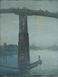
The River Thames has been a subject for artists, great and minor, over the centuries. Four major artists with works based on the Thames areCanaletto,J. M. W. Turner,Claude MonetandJames Abbott McNeill Whistler.[103]The 20th-century British artistStanley Spencerproduced many works atCookham.[104]
John Kaufman's sculptureThe Diver: Regenerationis sited in the Thames nearRainham.[105]
The river and bridges are portrayed as being destroyed – together with much of London – in the filmIndependence Day 2.[106]
- The Thames in the arts
-
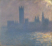 Houses of Parliament Sunlight Effect (Le Parlement effet de soleil) –Claude Monet
 -
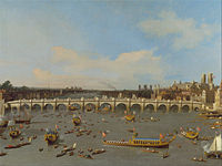 The firstWestminster Bridgeas painted byCanalettoin 1746
 -
 Maidenhead Railway BridgeasTurnersaw it in 1844
 -
-
 Foggy Morning on the Thames– James Hamilton (between 1872 and 1878)
 -
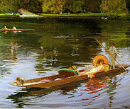 Boating on the Thames-John Lavery,c. 1890
 -
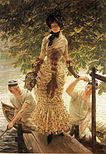 On the Thames-James Tissot,c. 1874


Literature[edit]

The Thames is mentioned in many works of literature including novels, diaries and poetry. It is the central theme in three in particular:
Three Men in a BoatbyJerome K. Jerome,first published in 1889, is a humorous account of a boating holiday on the Thames betweenKingstonandOxford.The book was intended initially to be a serious travel guide, with accounts of local history of places along the route, but the humorous elements eventually took over. The landscape and features of the Thames as described by Jerome are virtually unchanged, and the book's enduring popularity has meant that it has never been out of print since it was first published.
Charles Dickens'Our Mutual Friend(written in the years 1864–65) describes the river in a grimmer light. It begins with a scavenger and his daughter pulling a dead man from the river near London Bridge, to salvage what the body might have in its pockets, and leads to its conclusion with the deaths of the villains drowned inPlashwater Lockupstream. The workings of the river and the influence of the tides are described with great accuracy. Dickens opens the novel with this sketch of the river, and the people who work on it:
In these times of ours, though concerning the exact year there is no need to be precise, a boat of dirty and disreputable appearance, with two figures in it, floated on the Thames, betweenSouthwark Bridgewhich is of iron, andLondon Bridgewhich is of stone, as an autumn evening was closing in. The figures in this boat were those of a strong man with ragged grizzled hair and a sun-browned face, and a girl of nineteen or twenty. The girl rowed, pulling a pair of sculls very easily; the man with the rudder-lines slack in his hands, and his hands loose in his waisteband, kept an eager look-out.
Kenneth Grahame'sThe Wind in the Willows,written in 1908, is set in the middle to upper reaches of the river. It starts as a tale of anthropomorphic characters "simply messing about in boats" but develops into a more complex story combining elements of mysticism with adventure and reflection onEdwardiansociety. It is generally considered one of the most beloved works of children's literature[107]and the illustrations by E.H.Shepard and Arthur Rackham feature the Thames and its surroundings.
The river almost inevitably features in many books set in London. Most of Dickens' other novels include some aspect of the Thames.Oliver Twistfinishes in the slums androokeriesalong its south bank. TheSherlock Holmesstories byArthur Conan Doyleoften visit riverside parts as inThe Sign of Four.InHeart of DarknessbyJoseph Conrad,the serenity of the contemporary Thames is contrasted with the savagery of theCongo River,and with the wilderness of the Thames as it would have appeared to a Roman soldier posted to Britannia two thousand years before. Conrad also gives a description of the approach to London from theThames Estuaryin his essaysThe Mirror of the Sea(1906). Upriver,Henry James'Portrait of a Ladyuses a large riverside mansion on the Thames as one of its key settings.
Literary non-fiction works includeSamuel Pepys' diary, in which he recorded many events relating to the Thames including theFire of London.He was disturbed while writing it in June 1667 by the sound of gunfire as Dutch warships broke through theRoyal Navyon the Thames.
In poetry,William Wordsworth's sonnetOn Westminster Bridgecloses with the lines:
- Ne'er saw I, never felt, a calm so deep!
- The river glideth at his own sweet will:
- Dear God! the very houses seem asleep;
- And all that mighty heart is lying still!
T. S. Eliotmakes several references to the Thames inThe Fire Sermon, Section IIIofThe Waste Land.
TheSweet Thamesline is taken fromEdmund Spenser'sProthalamionwhich presents a more idyllic image:
- Along the shoare of silver streaming Themmes;
- Whose rutty banke, the which his river hemmes,
- Was paynted all with variable flowers.
- And all the meads adorn'd with daintie gemmes
- Fit to deck maydens bowres
Also writing of the upper reaches isMatthew ArnoldinThe Scholar Gypsy:
- Crossing the stripling Thames at Bab-lock-hythe
- Trailing in the cool stream thy fingers wet
- As the slow punt swings round
- Oh born in days when wits were fresh and clear
- And life ran gaily as the sparkling Thames;
- Before this strange disease of modern life.
Wendy Cope's poem 'After the Lunch' is set on Waterloo Bridge, beginning:
- On Waterloo Bridge, where we said our goodbyes,
- The weather conditions bring tears to my eyes.
- I wipe them away with a black woolly glove,
- And try not to notice I've fallen in love.
Dylan Thomasmentions the Thames in his poem "A Refusal to Mourn the Death, by Fire, of a Child in London". "London's Daughter", the subject of the poem, lays "Deep with the first dead...secret by the unmourning water of the riding Thames".

Science-fiction novels make liberal use of a futuristic Thames. The utopianNews from NowherebyWilliam Morrisis mainly the account of a journey through theThames valleyin a socialist future. The Thames features inH. G. Wells'The War of the Worlds.The Thames also features prominently inPhilip Pullman'sHis Dark Materialstrilogy, as a communications artery for the waterborne Gyptian people of Oxford and theFens,and as a prominent setting for his novelLa Belle Sauvage.
InThe Deptford Micetrilogy byRobin Jarvis,the Thames appears several times. In one book, rat characters swim through it toDeptford.Winner of theNestlé Children's Book PrizeGold AwardI, Coriander,by Sally Gardner is a fantasy novel in which the heroine lives on the banks of the Thames.Mark Wallingtondescribes a journey up the Thames in a camping skiff, in his 1989 bookBoogie up the River.
Many of the principal characters of theRivers of Londonurban fantasyseries byBen Aaronovitcharegenii locorum(local gods) associated with River Thames and its tributaries. This includesFather Thames,the original god of the Thames but now (in the books) confined to non-tidal reaches aboveTeddington Lockand Mama Thames the goddess of the tidal Thames below Teddington.
Music[edit]
TheWater Musiccomposed byGeorge Frideric Handelpremiered on 17 July 1717, whenKing George Irequested a concert on the River Thames. The concert was performed for King George I on his barge and he is said to have enjoyed it so much that he ordered the 50 exhausted musicians to play the suites three times on the trip.
The song 'Old Father Thames' was recorded byPeter DawsonatAbbey Road Studiosin 1933 and byGracie Fieldsfive years later.Jessie Matthewssings "My river" in the 1938 filmSailing Along,and the tune is the centrepiece of a major dance number near the end of the film.
TheSex Pistolsplayed a concert on theQueen Elizabeth Riverboaton 7 June 1977,Queen Elizabeth II's Silver Jubilee year, while sailing down the river. The choral line "(I)(liaised)live by the river "in the song"London Calling"bythe Clashrefers to the River Thames.
Two songs bythe Kinksfeature the Thames as the setting of the first song's title and, for the second song, arguably in its mention of 'the river': "Waterloo Sunset"is about a couple's meetings onWaterloo Bridge,London and starts: "Dirty old river, must you keep rolling, flowing into the night?" and continues "Terry meets Julie,Waterloo station"and"...but Terry and Julie cross over the river where they feel safe and sound... "."See My Friends"continually refers to the singer's friends" playing 'cross the river "instead of the girl who" just left ". Furthermore,Ray Daviesas a solo artist refers to the River Thames in his "London Song".[108]
Ewan MacColl's "Sweet Thames, Flow Softly", written in the early 1960s, is a tragic love ballad set on trip up the river (seeEdmund Spenser's love poem's refrain above).Culture Clubare travelling the River Thames in a riverboat in the video for "Karma Chameleon".English musicianImogen Heapwrote a song from the point of view of the River Thames entitled "You Know Where To Find Me". The song was released in 2012 on 18 October as the sixth single from her fourth albumSparks.[109]
Major flood events[edit]
London flood of 1928[edit]
The1928 Thames floodwas a disastrous flood of the River Thames that affected much of riverside London on 7 January 1928, as well as places further downriver. Fourteen people were drowned in London and thousands were made homeless when flood waters poured over the top of theThames Embankmentand part of theChelsea Embankmentcollapsed. It was the last major flood to affectcentral London,and, particularly following the disastrousNorth Sea flood of 1953,helped lead to the implementation of new flood-control measures that culminated in the construction of theThames Barrierin the 1970s.
Thames Valley flood of 1947[edit]
The1947 Thames floodwas overall the worst 20th-century flood of the River Thames, affecting much of theThames Valleyas well as elsewhere in England during the middle of March 1947 after a verysevere winter.
The floods were caused by 4.6 in (120 mm) of rainfall (including snow); the peak flow was 61.7×10⁹L (13.6×10⁹imp gal) of water per day and the damage cost a total of £12 million to repair.[110] Wardamage to some of thelocksmade matters worse.
Other significant Thames floods since 1947 have occurred in 1968, 1993, 1998, 2000, 2003, 2006 and 2014.

Canvey Island flood of 1953[edit]
On the night of 31 January, theNorth Sea flood of 1953devastated the island, taking the lives of 58 islanders and forcing the temporary evacuation of the 13,000 residents.[111]Canvey is consequently protected by modern sea defences comprising 15 mi (24 km) of concrete seawall.[112]Many of the victims were in the holiday bungalows of the eastern Newlands estate and perished as the water reached ceiling level. The small village area of the island is approximately two foot (0.6 m) above sea level and consequently escaped the effects of the flood.
See also[edit]
- Dartford Cable Tunnel
- Foreshore of the River Thames
- List of locations in the Port of London
- List of rivers of the United Kingdom
- Nore
- River and Rowing Museum
- Steamboat– reference Thames Steamboats
- Subterranean rivers of London
- Thames Discovery Programme
- Thames sailing barge
- Thames steamers
- Tyburn (stream)
References[edit]
Notes[edit]
- ^SeeTamsa River
- ^Chapter 5:The Celtic Element(P. H. Reaney)... The name is considered to be related to theSanskritTamasa( "dark water" ), the name of a tributary[a]of the River Ganges.[4]
- ^Chapter 5:The Celtic Element(P. H. Reaney). The common METamiseis a French form, as is the modern spelling with the FrenchTh–forT–(Thamis 1220).[4]
Citations[edit]
- ^"Ordnance Survey map".English Heritage.Archived fromthe originalon 24 April 2012.Retrieved11 December2018.
- ^"Designated Sites View: South Thames Estuary and Marshes".Sites of Special Scientific Interest. Natural England.Archivedfrom the original on 2 March 2018.Retrieved28 February2018.
- ^abMallory, J.P. and D.Q. Adams (1947).The Encyclopedia of Indo-European Culture.London: Fitzroy and Dearborn. p. 147.
- ^abcdeReaney 1969,p. 72.
- ^Jackson, Kenneth H(1955).The Pictish Language.inF. T. Wainright (ed.).The Problem of the Picts.Edinburgh: Nelson. pp. 129–166.
- ^Kitson, Peter R (1996). "British and European River Names'".Transactions of the Philological Society.94(2): 73–118.doi:10.1111/j.1467-968X.1996.tb01178.x.
- ^Henig M. & Booth P. (2000).Roman Oxfordshire,pp.118–119
- ^Sandoz, Ellis (ed.).The Roots of Liberty: Magna Carta...Indianapolis: Amagi/Liberty Fund. pp. 39, 347.
- ^Kendal, Roger; Bowen, Jane; Wortley, Laura (2002).Genius & Gentility: Henley in the Age of Enlightenment.Henley-on-Thames: River and Rowing Museum. pp. 12–13.ISBN9780953557127.
- ^Coates, Richard(1998). "A new explanation of the name of London".Transactions of the Philological Society.96(2): 203–229.doi:10.1111/1467-968X.00027.
- ^Cultural Heritage Resources (2005).Legendary Origins and the Origin of London's place nameArchived9 July 2011 at theWayback Machine.Retrieved 1 November 2005.
- ^Anthony David Mills (2001).Oxford Dictionary of London Place Names.Oxford University Press.ISBN978-0-19-280106-7.Archivedfrom the original on 13 September 2016.Retrieved25 October2015.
- ^TheNew Oxford Dictionary of English(1998)ISBN0-19-861263-Xp. 582 "East Endthe part of London east of theCityas far as the River Lea, including the Docklands ".
- ^"A Brief History of Canvey Island".Canvey Island Town Council.Archivedfrom the original on 27 August 2020.Retrieved27 August2020.
- ^"Thames Head, the Source of the River Thames".Britain Express.
- ^"The Source".THames Pathway.Archivedfrom the original on 27 August 2020.Retrieved27 August2020.
- ^Bailey, David (15 May 2012)."Tracing the source of the Thames".BBC News.Archivedfrom the original on 27 August 2020.Retrieved12 September2018.
- ^Hart, Dorothy (9 May 2004)."Seven Springs and the Churn".The-river-thames.co.uk. Archived fromthe originalon 16 May 2010.Retrieved17 May2010.
- ^Winn, Christopher (19 April 2018).I Never Knew That about the River Thames.Ebury Publishing.ISBN9780091933579.Archivedfrom the original on 27 August 2020.Retrieved20 January2019– via Google Books.
- ^Clayton, Phil (2012).Headwaters: Walking to British River Sources(First ed.). London: Frances Lincoln Limited. p. 38.ISBN9780711233638.
- ^"The River Severn Facts".BBC. Archived fromthe originalon 11 October 2007.Retrieved17 August2022.
- ^"Thames Estuary report highlights changes over decade".Southampton University. 23 February 2021.Retrieved13 August2023.
- ^"Thames Estuary 2100: Time to Plan and Time to Act".Environment Agency. 17 May 2023.Retrieved13 August2023.
- ^abcKhan, S. N.; Vane, C. H.; Horton, B. P.; Hillier, C.; Riding, J. B.; Kendrick, C. (2015)."The application of δ13C, TOC, C/N geochemistry to reconstruct Holocene relative sea levels and paleoenvironments in the Thames Estuary, UK".Journal of Quaternary Science.30(5): 417–433.Bibcode:2015JQS....30..417K.doi:10.1002/jqs.2784.S2CID12143258.Archivedfrom the original on 27 August 2020.Retrieved20 January2019– via ResearchGate.
- ^
- Barrow, Mandy."River Thames Basin".Primary Homework Help.Retrieved11 April2023.
- Futter, M. N.; Erlandsson, M. A.; Butterfield, D.; Whitehead, P. G.; Oni, S. K.; Wade, A. J. (28 February 2014)."PERSiST: a flexible rainfall-runoff modelling toolkit for use with the INCA family of models".Hydrology and Earth System Sciences.18(2): 855–873.Bibcode:2014HESS...18..855F.doi:10.5194/hess-18-855-2014.Archivedfrom the original on 15 August 2023.Retrieved11 April2023– via ResearchGate.
- M. N. Futter; M. A. Erlandsson; D. Butterfield; P. G. Whitehead; S. K. Oni; A. J. Wade (2014)."Map of the river Thames watershed showing the main branch of the Thames, underlying geology and boundaries for the 8 subcatchments used in the present study".PERSiST: A Flexible Rainfall-runoff Modelling Toolkit for Use with the INCA Family of Models.Hydrology and Earth System Sciences.18(2).Bibcode:2014HESS...18..855F.doi:10.5194/hess-18-855-2014.Archivedfrom the original on 11 April 2023.Retrieved11 April2023– via ResearchGate.
- ^abc"More about the Thames River Basin District".Environment Agency. 2 September 2011. Archived fromthe originalon 8 September 2011.Retrieved6 November2011.
- ^ab"Flow Gauging on the River Thames – The First 100 Years"(PDF).Hydrological Data. 1983. p. 33. Archived fromthe original(PDF)on 2 December 2011.Retrieved9 November2011.
- ^"UK Rivers Guide Book Guide to the River Thames – Jubilee River".Ukriversguidebook.co.uk. 23 January 2011. Archived fromthe originalon 3 May 2010.Retrieved2 April2012.
- ^"Environment Agency – A map indicating the location and route of the Jubilee River"(PDF).30 September 2007. Archived fromthe original(PDF)on 30 September 2007.Retrieved2 April2012.
- ^"Exclusive: water firms discharged raw sewage into England's rivers 200,000 times in 2019".The Guardian.1 July 2020.Archivedfrom the original on 27 August 2020.Retrieved4 August2020.
- ^"Is my river fit to play in?".The Rivers TRust.Archivedfrom the original on 5 August 2020.Retrieved4 August2020.
- ^"Report of the designated sewerage company for the entire Thames Basin and major supplier of London's water supply: Thames Water"(PDF).Archived fromthe original(PDF)on 31 January 2015.Retrieved20 November2012.
- ^"River Thames Free Fishing".River Thames Alliance.Archivedfrom the original on 29 November 2010.Retrieved10 June2010.
- ^Peter AckroydLondon:The BiographyVintage 2001
- ^"PortCities London".Archived fromthe originalon 29 December 2007.
- ^"History of the major rivers of southern Britain during the Tertiary".Quaternary Palaeoenvironments Group. 2006. Archived fromthe originalon 11 October 2007.Retrieved28 November2007.
- ^"The early Ice Age".www.geoessex.org.uk.Archived fromthe originalon 19 January 2016.Retrieved7 February2016.
- ^"Essex Wildlife Trust, The Geology of Essex".Archived fromthe originalon 21 October 2012.
- ^Ellison RA (2004),Geology of London,British Geological Survey, p58.
- ^"Retro: A river worth preserving".Ealing Gazette. 18 February 2011.Archivedfrom the original on 3 December 2020.Retrieved27 August2020.
- ^ab"History of the northwest European rivers during the past three million years".Quaternary Palaeoenvironments Group. 2007. Archived fromthe originalon 2 November 2007.Retrieved28 November2007.
- ^"Buckingham Surface Water Management Plan"(PDF).Buckinghamshire County Council.Archived(PDF)from the original on 27 August 2020.Retrieved27 August2020.
- ^Peter Ackroyd,Thames: The Biography.275.
- ^[1]The Evening Standard, 10 November 2021
- ^"The Greater Thames Shark Project".Zoological Society of London (ZSL).Retrieved29 April2022.
- ^Stevenson, Chris (19 August 2013)."Seal count discovers over 700 in Thames Estuary".The Independent.London.Archivedfrom the original on 27 August 2020.Retrieved23 August2013.
- ^"Whales, dolphins and seals returning to the Thames".Wildlife Extra.September 2007.Archivedfrom the original on 9 February 2015.Retrieved23 August2013.
- ^"Lost whale dies after rescue bid".BBC News.21 January 2006.Archivedfrom the original on 12 March 2012.Retrieved22 October2007.
- ^Needham, P. (1985). "Neolithic And Bronze Age Settlement on the Buried Floodplains of Runnymede".Oxford Journal of Archaeology.4(2): 125–137.doi:10.1111/j.1468-0092.1985.tb00237.x.
- ^Lamdin-Whymark, H. (2001). "Neolithic activity on the floodplain of the River Thames at Dorney".Lithics.22.
- ^abThe Physique of MiddlesexArchived28 September 2007 at theWayback Machine,A History of the County of Middlesex: Volume 1: Physique, Archaeology, Domesday, Ecclesiastical Organisation, The Jews, Religious Houses, Education of Working Classes to 1870, Private Education from Sixteenth Century (1969), pp. 1–10. Date Retrieved 11 August 2007.
- ^Gaius Julius CaesarDe Bello Gallico,Book 5, §§ 11, 18
- ^abPeter Ackroyd, Thames: The Biography, New York: Doubleday, 2007. "Filthy River"
- ^"Frost Fairs, London, UK".BBC. 11 March 2003.Archivedfrom the original on 6 January 2010.Retrieved21 March2007.
- ^"London, River Thames and Tower Bridge".VR London.Archivedfrom the original on 16 May 2007.Retrieved21 March2007.
- ^"Thames and Waterways".London Borough of Hammersmith & Fulham. Archived fromthe originalon 15 April 2015.Retrieved17 April2015.
- ^Schneer, Jonathan(2005).The Thames.Yale University Press. pp. 145–146.ISBN9780300107869.
- ^Peter Ackroyd, "Thames: Sacred River" 272–273
- ^abPeter Ackroyd,Thames: The Biography.272 & 274.
- ^Peter Ackroyd, "Thames: Sacred River" 272
- ^Peter Ackroyd "Thames: Sacred River" 274
- ^Environment Agency(2005).Jubilee RiverArchived25 February 2010 at theWayback Machine.
- ^"Thiess International Riverprize – International RiverFoundation".riverfoundation.org.au.Archivedfrom the original on 1 August 2017.Retrieved1 August2017.
- ^"Source of the River Thames moves fives miles for first time in its history".Gloucestershire Live. 5 August 2022.Retrieved12 August2022.
- ^"Salters Steamers website".Salterssteamers.co.uk.Archived fromthe originalon 29 May 2010.Retrieved17 May2010.
- ^"French Brothers".Simplon.Archivedfrom the original on 22 September 2020.Retrieved27 August2020.
- ^Hart, Dorothy (1 January 2000)."Floating Down the River website".The-river-thames.co.uk.Archivedfrom the original on 1 July 2017.Retrieved17 May2010.
- ^BBC News, 24 July 2014"Deaths in the River Thames reached 15 last year".BBC News online.Archivedfrom the original on 27 August 2020.Retrieved23 January2019..
- ^"Thames lifeboat service launched".BBC News.2 January 2002.Archivedfrom the original on 26 May 2004.Retrieved17 May2010.
- ^Port of London Authority."Terminal locations".Archived fromthe originalon 27 May 2008.Retrieved12 May2008.
- ^Port of London."Thames Bylaws 2012"(PDF).p. 20. Archived fromthe original(PDF)on 5 March 2014.Retrieved24 February2014.
- ^"Victoria County History of Oxfordshire: Rivers and river navigation".British-history.ac.uk.Archivedfrom the original on 27 August 2020.Retrieved17 May2010.
- ^Ditchfield, P. H.; Page, William (1906).The Victoria history of Berkshire.London: Constable.doi:10.5962/bhl.title.28982.Archivedfrom the original on 11 June 2021.Retrieved31 May2021.
- ^Cassell, Paul (1 November 2011)."Hydroelectric power comes to Mapledurham".Berkshire Live.Archivedfrom the original on 11 June 2020.Retrieved22 October2019.
- ^"The Queen goes gree: hydroelectric turbines arrive at Windsor Castle".Telegraph.8 September 2011.Archivedfrom the original on 27 August 2020.Retrieved27 August2020.
- ^"About Us".Osney Lock Hydro.Archivedfrom the original on 28 February 2022.Retrieved15 February2022.
- ^"Sandford Hydro".Low Carbon Hub.Archivedfrom the original on 15 February 2022.Retrieved15 February2022.
- ^"Reading Hydro Official Opening Ceremony".Reading Hydro CBS.Archivedfrom the original on 15 February 2022.Retrieved14 February2022.
- ^"History".Reconnecting London with the River Thames.Tideway. Archived fromthe originalon 14 September 2017.
- ^Vidal, John (9 June 2011)."Thousands of fish dead after Thames sewerage overflow".The Guardian.Archivedfrom the original on 27 August 2020.Retrieved18 February2018.
- ^Jeffries, Stuart (22 July 2014)."Water, super-sewers and the filth threatening the River Thames".The Guardian.Archivedfrom the original on 27 August 2020.Retrieved18 February2018.
- ^Laville, Sandra (13 May 2022)."Sewage dumps into English rivers widespread, criminal inquiry suspects".The Guardian.ISSN0261-3077.Retrieved21 April2023.
- ^"Update on Environment Agency Investigation - Creating a better place".environmentagency.blog.gov.uk.12 May 2022.Retrieved21 April2023.
- ^Laville, Sandra (23 January 2023)."Thames Water's real-time map confirms raw sewage discharges".The Guardian.ISSN0261-3077.Retrieved21 April2023.
- ^"EDM Map | Storm discharge data | River health".Thames Water.Retrieved21 April2023.
- ^"Reconnecting London with the River Thames".Tideway.Archivedfrom the original on 19 February 2018.Retrieved18 February2018.
- ^"'Super sewer' plans to go ahead ".BBC News.12 September 2014.Archivedfrom the original on 27 August 2020.Retrieved18 February2018.
- ^"River Ecology".Reconnecting London with the River Thames.Tideway. Archived fromthe originalon 18 February 2018.
- ^"London's super sewer won't solve the city's epic poop problem".Wired UK.ISSN1357-0978.Retrieved21 April2023.
- ^abcVane, C.H.; Beriro, D.; Turner, G. (2015),"Rise and fall of Mercury (Hg) pollution in sediment cores of the Thames Estuary, London, UK."(PDF),Earth and Environmental Science Transactions of the Royal Society of Edinburgh,105(4): 285–296,doi:10.1017/s1755691015000158,archived(PDF)from the original on 12 August 2016,retrieved17 June2016
- ^Vane, C. H.; Jones, D. G.; Lister, T. R. (2009)."Mercury contamination in surface sediments and sediment cores of the Mersey Estuary, UK"(PDF).Marine Pollution Bulletin.58(6): 940–946.Bibcode:2009MarPB..58..940V.doi:10.1016/j.marpolbul.2009.03.006.PMID19356771.Retrieved27 August2020.
- ^"River Thames 'severely polluted with plastic'".BBC News.21 July 2020.Retrieved21 April2023.
- ^Quadri, Sami (22 November 2022)."Food wrappers make up '20 per cent of lightweight plastic in Thames'".Evening Standard.Retrieved21 April2023.
- ^"Clubs celebrate £17.4 million Inspired Facilities funding".British Rowing. 22 December 2011.Archivedfrom the original on 26 September 2020.Retrieved27 August2020.
- ^Devizes to Westminster International Canoe RaceArchived29 August 2020 at theWayback Machine.Dwrace.org.uk. Retrieved on 27 August 2020.
- ^Pugh, Lewis (May 2010). "Achieving the Impossible. A Fearless Leader. A Fragile Earth". Simon & Schuster.
- ^"New by-law bans swimming in River Thames".BBC News.30 June 2012.Archivedfrom the original on 30 June 2012.Retrieved1 July2012.
- ^"The Big Thames Open Water Swim Series".Macmillan Cancer Support.Archived fromthe originalon 28 March 2012.Retrieved1 July2012.
- ^"Humanrace: Windsor".Speedo Open Water Swim Series.Archived fromthe originalon 1 July 2012.Retrieved1 July2012.
- ^"The Henley Swim".Archivedfrom the original on 27 August 2020.Retrieved1 July2012.
- ^"Walliams reflects on epic 140-mile Thames charity swim".BBC News.Archivedfrom the original on 27 August 2020.Retrieved1 July2012.
- ^Davies, Caitlin (4 May 2015)."The return of wild swimming: Swimming in the Thames is becoming the norm again".Independent.Archivedfrom the original on 6 December 2016.Retrieved27 August2020.
- ^"Artwork & Design".Illuminated River.Archivedfrom the original on 27 August 2020.Retrieved27 August2020.
- ^Scargill, Naila (18 December 2019)."Stanley Spencer's Love Affair With the Thames Revealed in New Show".Trebuchet.Archivedfrom the original on 25 October 2020.Retrieved27 August2020.
- ^"Local History – Concrete Barges and The Diver".London Riverside Bid.Archivedfrom the original on 27 August 2020.Retrieved27 August2020.
- ^Smith, Patrick (24 June 2016)."Independence Day: Resurgence and Brexit: the most brilliant movie marketing ploy of all time?".The Telegraph.Archivedfrom the original on 27 August 2020.Retrieved5 April2018.
- ^Grahame, Kenneth (2009).The Wind in the Willows: An Annotated Edition.Harvard University Press.ISBN978-0674034471.
- ^"Kinks Song List".Kindakinks.net. Archived fromthe originalon 7 December 2013.Retrieved2 April2012.
- ^You Know Where To Find MeArchived17 October 2012 at theWayback Machine.Imogen Heap. Retrieved on 17 July 2013.
- ^"Environment Agency - 1947 floods Thames".Archived fromthe originalon 6 December 2007.Retrieved19 April2011.
- ^Canvey Island's 13,000 refugeesArchived23 January 2021 at theWayback Machine.(2 February 1953).The Guardian(London), p. 1. Retrieved 29 July 2008.
- ^"Canvey Island Drainage scheme 2006". Environment agency. (May Avenue Pumping Station information board).
Sources[edit]
- James, Alan G. (2020).The Brittonic Language in the Old North, A Guide to the Place-Name Evidence, Volume 2.Scottish Place-Name Society.
- Reaney, P H (1969).The Origin of English Place Names.Routledge & Kegan Paul.
Further reading[edit]
- Ackroyd, Peter (2007).Thames: sacred river.London: Chatto & Windus.ISBN978-0-7011-7284-8.OCLC137313198.
- Cove-Smith, Chris (2006).The River Thames book: a guide to the Thames from the Barrier to Cricklade with the River Wey, Basingstoke Canal and Kennet & Avon Canal to Great Bedwyn(4th ed.). St. Ives, Cambridgeshire: Imray Laurie Norie & Wilson.ISBN978-0-85288-892-6.OCLC67613526.
- Dix, Frank L. (1985).Royal river highway: a history of the passenger boats and services on the River Thames.Newton Abbot; North Pomfret, Vt.: David & Charles.ISBN978-0-7153-8005-5.OCLC14355016.
- Milne, Gustav; Martin Bates; Mike D. Webber (June 1997). "Problems, potential and partial solutions: an archaeological study of the tidal Thames, England".World Archaeology.29(1–special issue, "Riverine archaeology," ed.James Graham–Campbell): 130–46.doi:10.1080/00438243.1997.9980367.ISSN0043-8243.
- Oliver, Stuart (June 2010). "Navigability and the improvement of the river Thames, 1605–1815".Geographical Journal.176(2): 164–77.Bibcode:2010GeogJ.176..164O.doi:10.1111/j.1475-4959.2010.00354.x.ISSN0016-7398.
- Sinclair, Mick (2007).The Thames: a cultural history.Oxford; New York: Oxford University Press.ISBN978-0-19-531492-2.OCLC77520502.
- Thacker, Fred S. (1968).The Thames Highway.Vol. 2: locks and weirs ([1st ed.], new impression ed.). Newton Abbot: David & Charles.ISBN978-0-7153-4233-6.OCLC55209571.
- The Royal river: the Thames, from source to sea: descriptive, historical, pictorial.Henley-on-Thames: Gresham. 1983 [1885].ISBN978-0-946095-05-6.OCLC17631247.
External links[edit]
- Where Thames Smooth Waters Glide – Pictures and history and tides and poetry and conditions
- The River Thames Society
- Thames Path National Trail
- River Thames London Hired Boats and News BlogArchived30 September 2022 at theWayback Machine
- BBC 4 documentaryIn search of Arcadiafeatures the river
| International | |
|---|---|
| National | |
| Geographic | |
| Other | |