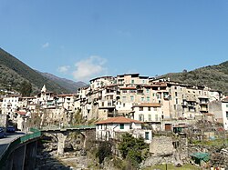
Rocchetta Nervina
Appearance
Rocchetta Nervina | |
|---|---|
| Comune di Rocchetta Nervina | |
 Rocchetta Nervina | |
| Coordinates:43°53′N7°36′E/ 43.883°N 7.600°E | |
| Country | Italy |
| Region | Liguria |
| Province | Imperia(IM) |
| Government | |
| • Mayor | Giampaolo Basso |
| Area | |
| • Total | 15.1 km2(5.8 sq mi) |
| Elevation | 235 m (771 ft) |
| Population (31 Dec. 2010)[2] | |
| • Total | 275 |
| • Density | 18/km2(47/sq mi) |
| Time zone | UTC+1(CET) |
| • Summer (DST) | UTC+2(CEST) |
| Postal code | 18030 |
| Dialing code | 0184 |
Rocchetta Nervina(Ligurian:A Rochetta[3]) is acomune(municipality) in theprovince of Imperiain theItalianregion ofLiguria.It is located about 120 kilometres (75 mi) southwest ofGenoaand about 35 kilometres (22 mi) west ofImperia,on the border withFrance.
Geography
[edit]As of 31 December 2010, Rocchetta Nervina had a population of 275 and an area of 15.1 square kilometres (5.8 sq mi).[4]
Rocchetta Nervina borders the following municipalities:Apricale,Breil-sur-Roya(France),Dolceacqua,Isolabona,PignaandSaorge(France).
Demographic evolution
[edit]
See also
[edit]References
[edit]- ^"Superficie di Comuni Province e Regioni italiane al 9 ottobre 2011".Italian National Institute of Statistics.Retrieved16 March2019.
- ^"Popolazione Residente al 1° Gennaio 2018".Italian National Institute of Statistics.Retrieved16 March2019.
- ^Frisoni, Gaetano[in Italian](1910).Dizionario Genovese-Italiano e Italiano-Genovese(in Italian). Genova: Nuova Editrice Genovese.
- ^All demographics and other statistics: Italian statistical instituteIstat.
External links
[edit]


