
Roihuvuori
You can helpexpand this article with text translated fromthe corresponding articlein Finnish.(June 2023)Click [show] for important translation instructions.
|
Roihuvuori
Kasberget | |
|---|---|
 Position of Roihuvuori within Helsinki | |
| Country | |
| Region | Uusimaa |
| Sub-region | Greater Helsinki |
| Municipality | Helsinki |
| District | Southeastern |
| Subdivision regions | none |
| Area | 1.47 km2(0.57 sq mi) |
| Population (2006) | 7,488 |
| • Density | 5,094/km2(13,190/sq mi) |
| Postal codes | 00800, 00810, 00811, 00820 |
| Subdivision number | 432 |
| Neighbouring subdivisions | Herttoniemenranta Itäkeskus Länsi-Herttoniemi Marjaniemi Roihupelto Tammisalo |
Roihuvuori(Swedish:Kasberget,orRoihisandRoihikka,literal translationBlaze Mountain) is aquarter,part ofHerttoniemineighbourhoodinHelsinki,Finland.The population of Roihuvuori is approximately 8,000 and its area is 1.47 km2.There is a church, two schools, shops and restaurants in Roihuvuori. There is also a water tower, Japanese style garden,playground TuhkimoandKirsikkapuistowhere aHanamifestival is held.
Each street in Roihuvuori was named after fairy tales, with the exception being Roihuvuori's main street (Roihuvuorentie). For example, Lumikintie is "Snow White Street" and Tuhkimotie is "Cinderella Street".
-
 Japanese style garden
 -
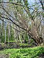 An alder forest at Strömsinlahti, Roihuvuori
 -
 The Roihuvuori water tower


Wikimedia Commons has media related toRoihuvuori.
| Southern Eteläinen Södra |
|  |
|---|---|---|
| Western Läntinen Västra | ||
| Central Keskinen Mellersta | ||
| Northern Pohjoinen Norra | ||
| Northeastern Koillinen Nordöstra | ||
| Southeastern Kaakkoinen Sydöstra | ||
| Eastern Itäinen Östra | ||
| Östersundom Östersundomin Östersundoms | ||
60°12′N25°04′E/ 60.200°N 25.067°E
ThisSouthern Finlandlocation article is astub.You can help Wikipedia byexpanding it. |