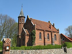
Rom, Germany
Rom | |
|---|---|
 Church in Paarsch | |
| Coordinates:53°27′N11°55′E/ 53.450°N 11.917°E | |
| Country | Germany |
| State | Mecklenburg-Vorpommern |
| District | Ludwigslust-Parchim |
| Municipal assoc. | Parchimer Umland |
| Subdivisions | 6 |
| Government | |
| •Mayor | Horst Klawuhn |
| Area | |
| • Total | 33.60 km2(12.97 sq mi) |
| Elevation | 58 m (190 ft) |
| Population (2022-12-31)[1] | |
| • Total | 804 |
| • Density | 24/km2(62/sq mi) |
| Time zone | UTC+01:00(CET) |
| • Summer (DST) | UTC+02:00(CEST) |
| Postal codes | 19372 |
| Dialling codes | 038731 |
| Vehicle registration | PCH |
| Website | www.amt-parchimer-umland.de |
Romis amunicipalityin theLudwigslust-Parchimdistrict, inMecklenburg-Vorpommern,Germany.
Geography and transport
[edit]The municipality is located 7 km east of Parchim and seven kilometers west of Lübz. TheBundesstraße 191runs through the community. TheBundesautobahn 24can be reached via the Parchim junction, which is 18 km away from Rom. The municipality is bordered by theMüritz-Elde waterwayin the south. TheDarzer Hochmoorand theWockertalare found in the northern part. Rom had a stop on theMecklenburg Southern Railway,theHaltepunktRom (Meckl).
The municipality of Rom includes the villages of Darze, Klein Niendorf, Lancken, Paarsch, Rome and Stralendorf.[2]
History
[edit]Lancken, as the oldest village of the municipality of Rom, was first mentioned in 1229 in a document.[3]From a formerMeierhof(around 1700) of the estate of Greven emerged an estate of the families of Hammerstein (from 1800) of Soden (1806), Knights of Henckel (after 1824) and of the families Blanck, Stucken and until 1945, Wesendorf. In 1830, the old manor house was demolished; under the Blanck family, the still existing mansion, a brick building with hipped roof, was completed in 1846. From 1960 onwards it served as a school, from 1984 onwards it was a children's holiday home, and it is now privately owned.[4]
Name
[edit]Rom was calledvilla Romein 1310,Romain 1320,Romein 1329, andRohmin 1621. The name comes from thePolabian languageand refers to theLokator:Ort des Rom ( "Rom's place" ).[5][6]
Merger of municipalities
[edit]On January 1, 1951, Stralendorf was incorporated into Darze. On the same day, Lancken became part of the municipality of Rom.
On June 13, 2004, Stralendorf was incorporated into Rom.[7]
References
[edit]- ^"Bevölkerungsstand der Kreise, Ämter und Gemeinden 2022"(XLS)(in German).Statistisches Amt Mecklenburg-Vorpommern.2023.
- ^§ 1 derArchived2014-02-01 at theWayback Machineder Gemeinde.
- ^MUB I. (1863) Nr. 370.1229. Juni 4. Parchim. Johann, Fürst von Meklenburg, bekennt, in den Dörfern Damm, Klokow, Lanken und Möderitz dem Kirchspiel Parchim 4 Capellen errichtet, und zur Entschädigung des Pfarrers zu Parchim die BurgCapelle daselbst mit 6 Hufen in Bök, welche Gerard von Malin geschenkt hatte, bewidmet zu haben.
- ^Gutshaus Lanckenbei www.gutshaeuser.de
- ^Paul Kühnel:Die slavischen Ortsnamen in Meklenburg.In: MJB Bd. 46 (1881) S. 3–168.
- ^Siering, Waldemar; Siering, Robert (April 17, 2013).Orte mit kuriosen Namen in Mecklenburg-Vorpommern: Von Aalbude bis Zitterpenningshagen.Steffen Verlag.ISBN9783942477482– via Google Books.
- ^Gebietsänderungen vom 01.01. bis 31.12.2004,Statistisches Bundesamt


