
Roxburghshire
Roxburgh
Siorrachd Rosbroig | |
|---|---|
 | |
| Country | Scotland |
| County town | Jedburgh |
| Area | |
| • Total | 666 sq mi (1,725 km2) |
| Ranked 12th of 34 | |
| Chapman code | ROX |
Roxburghshireor theCounty of Roxburgh(Scottish Gaelic:Siorrachd Rosbroig) is ahistoric countyandregistration countyin theSouthern UplandsofScotland.It bordersDumfriesshireto the west,SelkirkshireandMidlothianto the northwest, andBerwickshireto the north. To the southwest it bordersCumberlandand to the southeastNorthumberland,both inEngland.
It was named after theRoyal BurghofRoxburgh,a town which declined markedly in the 15th century and is no longer in existence. Latterly, thecounty townof Roxburghshire wasJedburgh.
The county has much the same area asTeviotdale,the basin drained by theRiver Teviotand tributaries, together with the adjacent stretch of the Tweed into which it flows. The term is often treated as synonymous with Roxburghshire, but may omitLiddesdaleasLiddel Waterdrains to the west coast.[1]
History
[edit]
The county appears to have originated in the 12th century with the creation of the sheriffdom of Roxburgh. The first known sheriff isGospatric (sheriff of Roxburgh).The hereditary sheriffship of Roxburghshire was possessed by the family of Douglas until theabolition of heritable jurisdictionsin the 18th century.[2]
The county was constantly fought over in the Middle Ages as part of theAnglo-Scottish Wars,before thebordersettled into roughly its modern form with theTreaty of Yorkin 1237.[3]The violence and lawlessness of these times gave rise to theBorder Reivers.
The ancient royal burgh of Roxburgh, from which the county had taken its name, fell into decay by the fifteenth century. After the demise of the town of Roxburgh, the county administration was based inJedburgh,the county town. County Buildings were erected near the market place in 1812, in which the different courts met and the county officials transacted their business.[4]
In 1855 Alexander Jeffrey published his book "The history and antiquities of Roxburghshire and adjacent districts, from the most remote period to the present time." It ran to four volumes.[5]
Geography
[edit]

Roxburghshire is a predominantly rural county, consisting of low hills rising to theCheviot Hillsalong the border with England. Just to the south of Melrose can be foundEildon Hill,a prominent local landmark. There are a few scattered lochs, though none of any significant size.
Transport
[edit]Other than terminus of the recently re-openedBorders Railway,of which two stations (GalashielsandTweedbank) lie within the county, there are no railways in Roxburghshire. There were formerly a number of lines serving the county, however these closed as a result of theBeeching cuts.
Demographics
[edit]The county has a population of 48,639 (in 2011),[6]which is 43% of the population of the Scottish Borders area.[7]
Today, the main towns in the county are (population in 2011):
Hawick is now by far the largest town, with 29% of the county's population. More than half the population live in the two parishes of Hawick and Melrose.[6]
Administration
[edit]Today, Roxburghshire is within theScottish Borderscouncil areafor local government purposes and contains theadministrative centreof the area, the small town ofNewtown St Boswells.It retains official status as aregistration county,and falls within theRoxburgh, Ettrick and Lauderdalelieutenancy areafor ceremonial purposes.
County
[edit]

Until 1975, Roxburghshire was used for local government. The original county town ofRoxburghwas abandoned following the destruction ofRoxburgh Castlein 1460 during theAnglo-Scottish Wars.Jedburghthen became the county town, serving as the location for thesheriff courtand meeting place of theCommissioners of Supply,which were established in 1667 as the county's main administrative body. The County Buildings on Castlegate in Jedburgh were built in 1812 to hold the sheriff court and be the meeting place for the commissioners.[8]
Thecounty councilwas created in 1890, taking most of the commissioners' functions. From 1890 until 1930 the council met at the County Buildings in Jedburgh. In 1930 the council moved its meeting place and headquarters toNewtown St Boswells.The council already had a branch office on Bowden Road in Newtown St Boswells, which it had built in 1896, and in 1930 the council inherited an adjoining building which had been built in 1928 for the short-lived Roxburghshire Education Authority.[9]The complex became known as theCounty Offices.A large new building designed byPeter Womersleywas added to the site in 1968.[10][11]
Roxburghshire County Council was abolished in 1975, when local government in Scotland was reorganised into upper-tier regions and lower-tier districts. Roxburghshire became part of theBordersregion. The County Offices at Newtown St Boswells became the headquarters for the new Borders Regional Council.[12]TheDuke of Buccleuchand theDuke of Roxburghebetween them had held the convenership of Roxburgh County Council for 43 years between 1900 and 1975.[13]
At the time of the county council's abolition in 1975, the county contained fourburghsand four districts (the districts generally covering the rural areas surrounding the town after which they were named):[14]
- HawickBurgh
- JedburghRoyal Burgh
- KelsoBurgh
- MelroseBurgh
- Hawick District
- Jedburgh District
- Kelso District
- Melrose District
District
[edit]| Roxburgh | |
|---|---|
| District | |
 | |
| History | |
| • Created | 16 May 1975 |
| • Abolished | 31 March 1996 |
| • Succeeded by | Scottish Borders |
| •HQ | Hawick |
| Contained within | |
| • Region | Borders |
TheLocal Government (Scotland) Act 1973abolished the county council and incorporated its area into theBorders Region.Borders was divided into four districts, one of which was named Roxburgh. Roxburgh District's borders broadly resembled those of the historic county, but included the parish ofNenthornfromBerwickshire,and excluded the parishes ofBowden,Lilliesleaf,Maxton,Melrose,andSt Boswells,which went instead to the newEttrick and LauderdaleDistrict.[14]Forlieutenancypurposes, the lastlord-lieutenantof the county of Roxburghshire was made lord-lieutenant for the district of Roxburgh when the reforms came into effect in 1975.[15]

Roxburgh District Council was based atHawick Town Hallwhich had been built in 1886 for the former Hawick Town Council.[16][17]
The region and four district councils were abolished in 1996, merging to form the presentScottish Borderscouncil area.[18]A new lieutenancy area was created at the same time, calledRoxburgh, Ettrick and Lauderdale,covering the combined area of the abolished districts of Roxburgh and neighbouring Ettrick and Lauderdale.[19]
Political control
[edit]The first election to the district council was held in 1974, initially operating as a shadow authority alongside the outgoing authorities until it came into its powers on 16 May 1975. Political control of the council from 1975 until its abolition in 1996 was as follows:[20]
| Party in control | Years | |
|---|---|---|
| Independent | 1975–1984 | |
| No overall control | 1984–1988 | |
| Independent | 1988–1992 | |
| No overall control | 1992–1996 | |
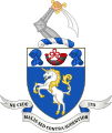
Coat of arms
[edit]The County of Roxburgh was the first Scottish county to receive a grant of arms. This was made byLord Lyon King of Armson 9 July 1798. Thecoat of armsseems to have been granted for the use of the volunteer and militia units then being organised under the authority of the county'slord lieutenant.When the county council was formed in 1890, the arms passed to them.
The shield depicted a unicorn, a national symbol of Scotland. At the top of the shield was a hunting horn between two helmets: probably a reference to the borderreivers,one of whom featured in the arms of the royal burgh of Jedburgh. The crest above the shield was an armoured arm brandishing a scimitar. TheLatinmotto wasNe Cede Malis Sed Contra Audentior ItoorYield not to misfortunes (evil things) but go on more boldly against them.,it was a quotation fromVirgil'sAeneid6, 95.[21]
On 6 May 1975 the coat of arms was regranted to Roxburgh District Council, without the crest.[22]When the district council was abolished in 1996, the arms reverted toThe Crown.
-
 Coat of arms of Roxburghshire County Council 1890–1962.
 -
 Coat of arms of Roxburghshire County Council 1962–1975.
 -
 Coat of arms of Roxburghshire District Council 1975–1996.


Civil parishes
[edit]
Following the boundary changes carried out under theLocal Government (Scotland) Act 1889,the county of Roxburgh contained 30 civil parishes:
- Ancrum(No.12 on map)
- Bedrule(22)
- Bowden(6)
- Castletonaka Liddesdale (31)
- Cavers(28)
- Crailing(15)
- Eckford(16)
- Ednam(5)
- Hawick(19)
- Hobkirk(29)
- Hownam(25)
- Jedburgh(23)
- Kelso(9)
- Lilliesleaf(11)
- Linton(17)
- Makerstoun(8)
- Maxton(13)
- Melrose(1)
- Minto(20)
- Morebattle(26)
- Oxnam(24)
- Roberton(18)
- Roxburgh(14)
- Smailholm(3)
- Southdean(30)
- Sprouston(10)
- St. Boswells(7)
- Stichill(4)
- Teviothead(27)
- Yetholm(21)
Defunct parishes and amalgamations
[edit]In medieval times there were 47 parishes, making the area the most densely parished in Scotland.
- Abbotrule: divided between Bedrule and Southdean in 1806.[23]
- Ettleton and Wheelkirk: absorbed into Castleton[24]
- Hassendean: divided between Minto, Roberton and Wilton, 17th century.[25]
- Jedworth, Old Jedworth and Upper Crailing: united to form the parish of Jedburgh.[26]
- Kirkton or Cavers Parva: absorbed into Cavers in 1895.[27]
- Lempitlaw: absorbed into Sprouston at the Reformation.[28]
- Longnewtown: absorbed into Ancrum in 1684.[29]
- Maxwell, Roxburgh Holy Sepulchre and Roxburgh St James: absorbed into Kelso (aka Kelso St Mary's), date unknown.[30][31]
- Mow: absorbed into Morebattle in 1672.[32]
- Nisbet and Spital: absorbed into Crailing 1606.[33]
- Rutherford: absorbed into Maxton.[34]
- Wilton: absorbed into Hawick post-1900.[35]
Settlements
[edit]


- Abbotrule
- Ancrum
- Appletreehall
- Ashkirk
- Bairnkine
- Bedrule
- Bonchester Bridge
- Bowden
- Branxholme
- Broadhaugh
- Burnfoot
- Camptown
- Crailing
- Crailinghall
- Darnick
- Denholm
- Eckford
- Edgerston
- Ednam
- Eildon
- Galashiels(shared with Selkirkshire)
- Gattonside
- Hallrule
- Hawick
- Heiton
- Hobkirk
- Hownam
- Jedburgh
- Kelso
- Kirkton
- Kirk Yetholm
- Lempitlaw
- Lilliesleaf
- Lindean
- Linton
- Longnewton, Roxburghshire
- Maxton
- Melrose
- Midlem
- Minto
- Morebattle
- Newcastleton
- Newstead
- Newtown St Boswells
- Nisbet
- Oxnam
- Roxburgh
- St Boswells
- Smailholm
- Southdean
- Spittal-on-Rule
- Sprouston
- Stichill
- Town Yetholm
- Tweedbank
- Wilton
- Wilton Dean
Notable residents
[edit]- Robert Livingston the Elder,(1654–1728), born in Ancrum, was the Secretary for Indian affairs of the New York Province and the first lord ofLivingston Manor.[36]
- Thomas Pringlethe nineteenth century Scottish writer, poet and abolitionist was born at Blakelaw, a 500-acre (2.0 km2) farmstead four miles (6 km) to the south of the town of Kelso where his father was the tenant.
- Henry Scott Riddell(1798–1870), the poet, was buried at Teviothead and is commemorated by a monument on a nearby hill.[37]
- "Chief" Robert Riddell (1820–1921), brother of the poet, born in Teviotdale, was a Scottish-Canadian pioneer and veteran of theUpper Canada Rebellion.He is noted for having pioneered thetownship of Beverly in Ontario.
- Thomas B. Scott(1829–1886), President Pro Tem of theWisconsin State Senate.
See also
[edit]References
[edit]- ^Ordnance Gazetteer of Scotland, by, Francis Groome, publ. 2nd edition 1896. Article on Roxburghshire
- ^New Statistical Account of Scotland, Vol III Roxburgh, Peebles, Selkirk, publ.William Blackwood, 1845, p.430
- ^"Treaty of York – 1237".BBC.Retrieved24 September2017.
- ^Groome's Ordnance Gazetteer of Scotland, 2nd edition, published 1896. Article on Jedburgh
- ^"archive search".Retrieved11 February2019.
- ^abCensus of Scotland 2011, Table KS101SC – Usual Resident Population, published byNational Records of Scotland.Area type: Civil Parish 1930; calculated total for all Roxburghshire parishes
- ^Census of Scotland 2011, Table KS101SC – Usual Resident Population, published by National Records of Scotland. Area type: Council Area
- ^Historic Environment Scotland."Jedburgh Sheriff Court and Justice of the Peace Court (Former County Buildings) including wall and railings, Castlegate, Jedburgh (Category B Listed Building) (LB35503)".Retrieved12 December2022.
- ^"County Council meeting: Jedburgh meeting place to be abandoned".Hawick News.19 December 1930. p. 6.Retrieved13 December2022.
- ^"Roxburgh County Buildings".Dictionary of Scottish Architects.Retrieved13 December2022.
- ^"Roxburgh County Offices, Newtown St Boswells".Canmore.Historic Environment Scotland.Retrieved13 December2022.
- ^"No. 19753".The Edinburgh Gazette.10 October 1975. p. 1319.
- ^Blossom: What Scotland Needs to Flourish, by Lesley Riddoch, chapter 7, pub. 2013
- ^ab"Local Government (Scotland) Act 1973",legislation.gov.uk,The National Archives,1973 c. 65,retrieved22 November2022
- ^"The Lord-Lieutenants Order 1975",legislation.gov.uk,The National Archives,SI 1975/428,retrieved27 November2022
- ^Historic Environment Scotland."34-44 High Street (Even numbers), Hawick Town Hall (LB34634)".Retrieved16 September2022.
- ^"No. 23569".The Edinburgh Gazette.29 April 1994. p. 999.
- ^"Local Government etc. (Scotland) Act 1994",legislation.gov.uk,The National Archives,1994 c. 39,retrieved16 December2022
- ^"The Lord-Lieutenants (Scotland) Order 1996",legislation.gov.uk,The National Archives,SI 1996/731,retrieved16 December2022
- ^"Compositions calculator".The Elections Centre.4 March 2016.Retrieved2 December2022.
- ^R. M. Urquhart,Scottish Burgh and County Heraldry,London, 1973
- ^R. M. Urquhart,Scottish Civic Heraldry,London, 1979
- ^"Southdean and Abbotsrule".www.bordersfhs.org.uk.Retrieved30 January2021.
- ^"List of amalgamations"(PDF).Scottish Place-Name Society.
- ^GENUKI."Genuki: Hassendean, Roxburghshire".www.genuki.org.uk.Retrieved30 January2021.
- ^"Parish of Jedburgh from The Gazetteer for Scotland".www.scottish-places.info.Retrieved30 January2021.
- ^Edinburgh Gazette (official journal of the government), 5/3/1895 p. 295; and 18/12/1894 pp. 1449-1450
- ^"Parish of Sprouston from The Gazetteer for Scotland".www.scottish-places.info.Retrieved30 January2021.
- ^GENUKI."Genuki: Ancrum, Roxburghshire".www.genuki.org.uk.Retrieved30 January2021.
- ^"Saints in Scottish Place-Names - Old Roxburgh, former parish, Roxburgh".saintsplaces.gla.ac.uk.Retrieved31 January2021.
- ^"Parish of Kelso from The Gazetteer for Scotland".www.scottish-places.info.Retrieved30 January2021.
- ^"Mow Tower | Canmore".canmore.org.uk.Retrieved31 January2021.
- ^"Parish Profile".Ale and Teviot United Church.Retrieved28 January2021.
- ^GENUKI."Genuki: Maxton, Roxburghshire".www.genuki.org.uk.Retrieved30 January2021.
- ^"History of Wilton, in Scottish Borders and Roxburghshire | Map and description".Archived fromthe originalon 1 October 2014.
- ^Who Was Who in America, Historical Volume, 1607-1896.Chicago: Marquis Who's Who. 1963.
- ^.Encyclopædia Britannica.Vol. 26 (11th ed.). 1911. p. 686.
- Edina.ac.ukArchived8 March 2007 at theWayback Machine,A Vision of Britain Through Time: Descriptive gazetteer entries for Roxburghshire
External links
[edit]- Map of Roxburghshireon Wikishire
Local government areasofScotland,in use 1975 to 1996 | ||
|---|---|---|
| Borders |  | |
| Central Region | ||
| Dumfries and Galloway | ||
| Fife | ||
| Grampian | ||
| Highland | ||
| Lothian | ||
| Strathclyde | ||
| Tayside | ||
| Island areas1 | ||
| International | |
|---|---|
| National | |