
Rypin
Rypin | |
|---|---|
 Nowy Rynek(New Market Square) | |
 Flag  Coat of arms | |
 Rypin | |
| Coordinates:53°4′N19°27′E/ 53.067°N 19.450°E | |
| Country | |
| Voivodeship | Kuyavian-Pomeranian |
| County | Rypin |
| Gmina | Rypin(urban gmina) |
| Town rights | 14th century |
| Government | |
| • Mayor | Pawel Grzybowski (PiS) |
| Area | |
| • Total | 10.96 km2(4.23 sq mi) |
| Population (2010)[1] | |
| • Total | 16,528 |
| • Density | 1,500/km2(3,900/sq mi) |
| Time zone | UTC+1(CET) |
| • Summer (DST) | UTC+2(CEST) |
| Postal code | 87-500 |
| Car plates | CRY |
| Voivodeship roads | |
| Website | http://www.rypin.eu/ |
Rypin[ˈrɨpʲin]is a town in north-centralPoland,inKuyavian-Pomeranian Voivodeship,about 50 km east ofToruń.It is the capital ofRypin County.Population is 16,528 (2010).[1]
History
[edit]
Rypin was founded in theMiddle Ages,and was part of Poland since the establishment of the state in the 10th century. From the 11th century it was the seat of a localcastellany,and from the 14th century it was a county seat. It was grantedtown rightsin the early 14th century, and afterwards it was aroyal townof thePolish Crown,administratively located in theDobrzyń Landin theInowrocław Voivodeshipin theGreater Poland Province.In the early 14th century, local dukes of the PolishPiast dynastyfounded a hospital in Rypin to commemorate their deceased father DukeSiemowit of Dobrzyń.[2]In 1352, the hospital was granted variousprivilegesby DukeWładysław the Hunchback.[2]Rypin was located on a trade route connectingToruńwithBrześć.[3]The 1st Polish National Cavalry Brigade was stationed in the town.[4]
Following theSecond Partition of Poland(1793), the town was annexed byKingdom of Prussia.In 1807, it passed to the short-lived PolishDuchy of Warsaw,and after its dissolution in 1815, it became part of theRussian Partitionof Poland. During theJanuary Uprising,Polish insurgents captured the town on February 4, 1863.[5]FollowingWorld War I,Poland regained independence and control of Rypin. During thePolish–Soviet War,Rypin was occupied by Russians on 14 August 1920, and liberated by Poles on 20 August 1920.
World War II
[edit]
During the German invasion of Poland, which startedWorld War IIin September 1939, the town was invaded and thenoccupied by Germanyuntil 1945. ThePolishpopulation was subjected to an extensivegenocidal campaign.In September 1939, a German police prison was established in the town, and in October 1939, the German police andSelbstschutzcarried out mass arrests of local Poles.[6]Hundreds of arrested Poles were interrogated and then murdered on the spot and buried in nearbySkrwilno,during the German-perpetratedIntelligenzaktion.[7]Among the victims were 96 Polish teachers and school principals from the town and county.[7]Many local Poles were also murdered during large massacres carried out by the Germans in Skrwilno in October and November 1939.[8]In 1944 the occupiers burned the victims' bodies in attempt to cover up the crime committed in Skrwilno.[8]Poles were also murdered in other places in Rypin, and around 200 Poles from the town and county were massacred in the nearby village ofRusinowo.[9]In 1939–1942, the Germans alsoexpelledover 5,100 Poles from the town.[10]Most of the expelled Poles were imprisoned in a transit camp inToruńand then deported to theGeneral Governmentin the more-eastern part of German-occupied Poland, as their houses were handed over toGermancolonists as part of theLebensraumpolicy.[11]According to aGestapodocument from 1942, many remaining Poles fled from Rypin trying to avoid signing to theDeutsche Volksliste,however, many Poles eventually signed under the threat of deportation toGerman concentration camps.[12]A transit camp for Poles expelled from nearby villages in 1942 was operated in the town.[13]Rypin was liberated by the Soviet Army at the end of 1944.
| Year | Pop. | ±% |
|---|---|---|
| 1921 | 7,234 | — |
| 1931 | 8,348 | +15.4% |
| 2010 | 16,528 | +98.0% |
| Source:[14][1] | ||
Notable people
[edit]- Andrzej Fałkowski(born 1959), Polish army officer
- Chaja Goldstein(1908–1999), dancer and singer
- Ivor Mairants(1908–1998), jazz and classical guitarist
- Zbigniew Sosnowski(born 1963), politician
- Jacob Talmon(1916–1980), Professor of Modern History at the Hebrew University of Jerusalem
- Faustin E. Wirkus(1896–1945), American marine
Sport
[edit]- Lech Rypin- football club
Gallery
[edit]-
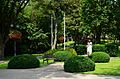 MarshalJózef PiłsudskiPark with the Piłsudski Monument
 -
 Galeria Młynshopping mall
 -
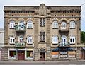 Art Nouveauarchitecture
 -
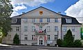 Town hall, local seat of authorities


See also
[edit]Near to Rypin isLake Urszulewo.
References
[edit]- ^abcStan i struktura ludności oraz ruch naturalny w przekroju terytorialnym w 2010 r.(PDF)(in Polish). Warszawa: Główny Urząd Statystyczny. 2011. p. 52. Archived fromthe original(PDF)on 13 November 2011.
- ^abSłownik geograficzny Królestwa Polskiego i innych krajów słowiańskich, Tom XV cz.2(in Polish). Warszawa. 1902. p. 566.
{{cite book}}:CS1 maint: location missing publisher (link) - ^Bartoszewicz, Henryk (1994). "Drogi handlowe ziemi dobrzyńskiej w XV–XVI w.".Miscellanea Historico-Archivistica(in Polish). Vol. IV. Warszawa: Naczelna Dyrekcja Archiwów Państwowych, Wydawnictwo DiG. p. 167.ISSN0860-1054.
- ^Gembarzewski, Bronisław (1925).Rodowody pułków polskich i oddziałów równorzędnych od r. 1717 do r. 1831(in Polish). Warszawa: Towarzystwo Wiedzy Wojskowej. p. 7.
- ^Zieliński, Stanisław (1913).Bitwy i potyczki 1863-1864. Na podstawie materyałów drukowanych i rękopiśmiennych Muzeum Narodowego w Rapperswilu(in Polish). Rapperswil: Fundusz WydawniczyMuzeum Narodowego w Rapperswilu.p. 225.
- ^Wardzyńska, Maria (2009).Był rok 1939. Operacja niemieckiej policji bezpieczeństwa w Polsce. Intelligenzaktion(in Polish). Warszawa:IPN.pp. 171, 173.
- ^abWardzyńska (2009), p. 173
- ^abWardzyńska (2009), p. 174
- ^Wardzyńska (2009), p. 175
- ^Wardzyńska, Maria (2017).Wysiedlenia ludności polskiej z okupowanych ziem polskich włączonych do III Rzeszy w latach 1939-1945(in Polish). Warszawa: IPN. pp. 60, 76, 103, 124.ISBN978-83-8098-174-4.
- ^Wardzyńska (2017), p. 76, 103
- ^Wardzyńska (2017), p. 114
- ^Wardzyńska (2017), p. 124
- ^Wiadomości Statystyczne Głównego Urzędu Statystycznego(in Polish). Vol. X. Warszawa: Główny Urząd Statystyczny. 1932. p. 194.
External links
[edit]| Seat |
|  |
|---|---|---|
| Rural gminas | ||

| International | |
|---|---|
| National | |
| Geographic | |