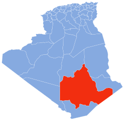
Sahla Tahtania
Appearance
Sahla Tahtania | |
|---|---|
Village | |
| Coordinates:27°16′39″N2°29′25″E/ 27.27750°N 2.49028°E | |
| Country | |
| Province | Tamanrasset Province |
| District | In Salah District |
| Commune | In Salah[1] |
| Elevation | 275 m (902 ft) |
| Time zone | UTC+1(CET) |
Sahla Tahtania(also writtenSahela Tahtania) is a village in thecommuneofIn Salah,[1]inIn Salah District,Tamanrasset Province,Algeria.It is located just to the west of the N1 national highway, 9 kilometres (5.6 mi) north of the town of In Salah.[2]
References
[edit]- ^ab"Décret n° 84-365, fixant la composition, la consistance et les limites territoriale des communes. Wilaya d'El Oued"(PDF)(in French). Journal officiel de la République Algérienne. 19 December 1984. p. 1495. Archived fromthe original(PDF)on 2013-12-26.Retrieved6 June2013.
- ^"Sahela Tahtania, Algeria".Geonames.org.Retrieved20 June2013.
Neighbouring towns and cities


