
Santorini
Santorini / Thira
Σαντορίνη/Θήρα | |
|---|---|
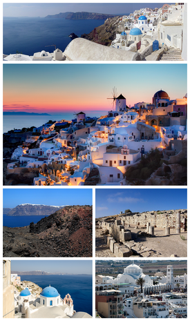 Clockwise from top:Partial panoramic view of Santorini, sunset in the village ofOia,ruins of the Stoa Basilica atAncient Thera,theOrthodox Metropolitan Cathedral of Ypapantiat the town ofFira,theAegean Seaas seen from Oia, and view of Fira from the island ofNea Kameniat theSantorini caldera. | |
 Santorini / Thira Location within the region  | |
| Coordinates:36°24′54″N25°25′57″E/ 36.41500°N 25.43250°E | |
| Country | Greece |
| Administrative region | South Aegean |
| Regional unit | Thira |
| Government | |
| • Mayor | Anastasios Zorzos[1](since 2023) |
| Area | |
| • Municipality | 90.69 km2(35.02 sq mi) |
| Population (2021)[2] | |
| • Municipality | 15,480 |
| • Density | 170/km2(440/sq mi) |
| • Municipal unit | 14,393 |
| • Community | 1,516 |
| Time zone | UTC+2(EET) |
| • Summer (DST) | UTC+3(EEST) |
| Postal code | 847 00, 847 02 |
| Area code(s) | 22860 |
| Vehicle registration | EM |
| Website | www.thira.gr |

Santorini(Greek:Σαντορίνη,romanized:Santoríni,pronounced[sa(n)doˈrini]), officiallyThira(Greek:Θήρα,romanized:Thíra,pronounced[ˈθira]) andClassical GreekThera(/ˈθɪərə/), is aGreekisland in the southernAegean Sea,about 200 km (120 mi) southeast from its mainland. It is the largest island of a small, circulararchipelagoformed by theSantorini caldera.It is the southernmost member of theCycladesgroup of islands, with an area of approximately 73 km2(28 sq mi) and a 2021 census population of 15,480. The municipality of Santorini includes the inhabited islands of Santorini andTherasia,as well as the uninhabited islands ofNea Kameni,Palaia Kameni,AspronisiandChristiana.The total land area is 90.623 km2(34.990 sq mi).[3]Santorini is part of theThira regional unit.[4]
The island was the site of one of the largestvolcanic eruptionsinrecorded history:theMinoan eruption(sometimes called the Thera eruption), which occurred about 3,600 years ago at the height of theMinoan civilization.[5]The eruption left a large caldera surrounded byvolcanic ashdeposits hundreds of metres deep.
It is the most active volcanic centre in theSouth Aegean Volcanic Arc,though what remains today is chiefly a water-filled caldera. The volcanic arc is approximately 500 km (300 mi) long and 20 to 40 km (12 to 25 mi) wide. The region first became volcanically active around 3–4 million years ago,[citation needed]though volcanism on Thera began around 2 million years ago with the extrusion ofdaciticlavas from vents aroundAkrotiri.
Names[edit]
Santorini was named by theLatin Empirein the thirteenth century, and is a reference toSaint Irene,from the name of the old church in the village ofPerissa– the name Santorini is a contraction of the name Santa Irini.[6][5]Before then, it was known as Kallístē (Καλλίστη,"the most beautiful one"), Strongýlē (Στρογγύλη,"the circular one"),[7]or Thēra. The ancient nameThera,forTheras,the leader of the Spartans who colonized and gave his name to the island,[8]was revived in the nineteenth century as the official name of the island and its main city, but the colloquialSantoriniis still in popular use.
History[edit]
Minoan Akrotiri[edit]


Excavations starting in 1967 at theAkrotirisite under the late ProfessorSpyridon Marinatoshave made Thera the best-knownMinoansite outsideCrete,homeland of the culture. The island was not known as Thera at this time. Only the southern tip of a large town has been uncovered, yet it has revealed complexes of multi-level buildings, streets, and squares with remains of walls standing as high as eight metres, all entombed in the solidified ash of the famous eruption of Thera. The site was not a palace-complex as found inCretenor was it a conglomeration of merchant warehousing. Its excellent masonry and fine wall-paintings reveal a complex community. A loom-workshop suggests organizedtextileweavingfor export. ThisBronze Agecivilization thrived between 3000 and 2000 BC, reaching its peak in the period between 2000 and 1630 BC.[9]
Many of the houses in Akrotiri are major structures, some of them three storeys high. Its streets, squares, and walls were preserved in the layers of ejecta, sometimes as tall as eight metres, indicating this was a major town. In many houses stone staircases are still intact, and they contain huge ceramic storage jars (pithoi), mills, and pottery. Noted archaeological remains found in Akrotiri are wall paintings orfrescoesthat have kept their original colour well, as they were preserved under many metres of volcanic ash. Judging from the fine artwork, its citizens were sophisticated and relatively wealthy people. Among more complete frescoes found in one house are twoantelopespainted with a confident calligraphic line, a man holding fish strung by their gills, a flotilla of pleasure boats that are accompanied by leapingdolphins,and a scene of women sitting in the shade of light canopies. Fragmentary wall-paintings found at one site are Minoan frescoes that depict "Saffron-gatherers "offeringcrocus-stamens to a seated woman, perhaps agoddessimportant to the Akrotiri culture. The themes of the Akrotiri frescoes show no relationship to the typical content of theClassical Greek décorof 510 BC to 323 BC that depict the Greek pantheon deities.
The town also had a highly developed drainage system. Pipes with running water andwater closetsfound at Akrotiri are the oldest such utilities discovered.[10]The pipes run in twin systems, indicating that Therans used both hot and cold water supplies. The origin of the hot water they circulated in the town probably wasgeothermic,given thevolcano's proximity.
The well preserved ruins of the ancient town are often compared to the spectacular ruins atPompeiiin Italy. The canopy covering the ruins collapsed in an accident in September 2005, killing one tourist and injuring seven more. The site was closed for almost seven years while a new canopy was built. The site was re-opened in April 2012.
The oldest signs of human settlement are LateNeolithic(4th millennium BC or earlier), but c. 2000–1650 BC Akrotiri developed into one of the Aegean's majorBronze Ageports, with recovered objects that came not just fromCrete,but also fromAnatolia,Cyprus,Syria,andEgypt,as well as from theDodecaneseand the Greek mainland.
Dating of the Bronze Age eruption[edit]


TheMinoan eruptionprovides a fixed point for the chronology of the second millennium BC in the Aegean, because evidence of the eruption occurs throughout the region and the site itself contains material culture from outside. The eruption occurred during the "Late Minoan IA" period ofMinoan chronologyat Crete and the "Late Cycladic I" period in the surrounding islands.
Archaeological evidence, based on an established chronology of Bronze Age Mediterranean cultures, dated the eruption to around 1500 BC.[11]These dates, however, conflict withradiocarbon datingwhich indicated that the eruption occurred between 1645–1600 BC,[12][13]and tree ring data which yielded a date of 1628 BC.[14]For those, and other reasons, the previous culturally based chronology has generally been questioned.[15]
Ancient period[edit]


Santorini remained unoccupied throughout the rest of the Bronze Age, during which time the Greeks took overCrete.AtKnossos,in a LMIIIA context (14th century BC), sevenLinear Btexts while calling upon "all the deities" make sure to grant primacy to an elsewhere-unattested entity calledqe-ra-si-jaand, once,qe-ra-si-jo.If the endings-ia[s]and-iosrepresent an ethnic suffix, then this means "The One From Qeras[os]". If the initial consonant were aspirated, then *Qhera- would have become "Thera-" in later Greek. "Therasia" and its ethnikon "Therasios" are both attested in later Greek; and, since-soswas itself a genitive suffix in the AegeanSprachbund,*Qeras[os] could also shrink to *Qera. Ifqe-ra-si-jawas an ethnikon first, then in following the entity the Cretans also feared whence it came.[16]
Probably after what is called theBronze Age collapse,Phoeniciansfounded a site on Thera.Herodotusreports that they called the island Callista and lived on it for eight generations.[17]In the ninth century BC,Doriansfounded the main Hellenic city on Mesa Vouno, 396 m (1,299 ft)above sea level.This group later claimed that they had named the city and the island after their leader,Theras.Today, that city is referred to asAncient Thera.
In hisArgonautica,written in Hellenistic Egypt in the third century BC,Apollonius Rhodiusincludes an origin and sovereignty myth of Thera being given byTritonin Libya to the GreekArgonautEuphemus,son ofPoseidon,in the form of a clod of dirt. After carrying the dirt next to his heart for several days, Euphemus dreamt that he nursed the dirt with milk from his breast, and that the dirt turned into a beautiful woman with whom he had sex. The woman then told him that she was a daughter of Triton namedCalliste,and that when he threw the dirt into the sea it would grow into an island for his descendants to live on. The poem goes on to claim that the island was named Thera after Euphemus' descendantTheras,son ofAutesion,the leader of a group of refugee settlers fromLemnos.
The Dorians have left a number of inscriptions incised in stone, in the vicinity of the temple ofApollo,attesting topederastic relationsbetween the authors and their lovers (eromenoi). These inscriptions, found byFriedrich Hiller von Gaertringen,have been thought by some archaeologists to be of a ritual, celebratory nature, because of their large size, careful construction and – in some cases – execution by craftsmen other than the authors. According toHerodotus,[18]following a drought of seven years, Thera sent out colonists who founded a number of cities in northern Africa, includingCyrene.In the fifth century BC, Dorian Thera did not join theDelian LeaguewithAthens;and during thePeloponnesian War,Thera sided with Dorian Sparta, against Athens. The Athenians took the island during the war, but lost it again after theBattle of Aegospotami.During the Hellenistic period, the island was a major naval base forPtolemaic Egypt.
Medieval and Ottoman period[edit]

As with other Greek territories, Thera then was ruled by theRomans.When theRoman Empirewas divided, the island passed to the eastern side of the Empire which today is known as theByzantine Empire.[19]According toGeorge Cedrenus,the volcano erupted again in the summer of 727, the tenth year of the reign ofLeo III the Isaurian.[20]He writes: "In the same year, in the summer, a vapour like an oven's fire boiled up for days out of the middle of the islands of Thera and Therasia from the depths of the sea, and the whole place burned like fire, little by little thickening and turning to stone, and the air seemed to be a fiery torch." This terrifying explosion was interpreted as a divine omen against the worship of religiousicons[21][22]and gave the EmperorLeo III the Isaurianthe justification he needed to begin implementing hisIconoclasmpolicy.
The name "Santorini" first appearsc. 1153-1154in the work of the Muslim geographeral-Idrisi,as "Santurin", from the island's patron saint,Saint Irene.[23]After theFourth Crusade,it was occupied by theDuchy of Naxoswhich held it up to circa 1280 when it was reconquered byLicario(the claims of earlier historians that the island had been held byJacopo I Barozziand his son as a fief have been refuted in the second half of the twentieth century);[24][25][26]it was again reconquered from the Byzantines circa 1301 byIacopo II Barozzi,a member of the Cretan branch of the VenetianBarozzifamily, whose descendant held it until it was annexed inc. 1335byNiccolo Sanudoafter various legal and military conflicts.[27]In 1318–1331 and 1345–1360 it was raided by theTurkishprincipalities ofMentesheandAydın,but did not suffer much damage.[23]Because of the Venetians the island became home to a sizable Catholic community and is still the seat of aCatholic bishopric.
From the 15th century on, the suzerainty of theRepublic of Veniceover the island was recognized in a series of treaties by theOttoman Empire,but this did not stop Ottoman raids, until it was captured by the Ottoman admiralPiyale Pashain 1576, as part of a process of annexation of most remaining Latin possessions in the Aegean.[23]It became part of the semi-autonomous domain of the Sultan's Jewish favourite,Joseph Nasi.Santorini retained its privileged position in the 17th century, but suffered in turn from Venetian raids during the frequentOttoman–Venetian warsof the period, even though there were no Muslims on the island.[23]
Santorini was captured briefly by theRussiansunderAlexey Orlovduring theRusso-Turkish War of 1768–1774,but returned to Ottoman control after.
19th century[edit]
In 1807, the islanders were forced by theSublime Porteto send 50 sailors to Mykonos to serve in the Ottoman navy.[28]
In 1810, Santorini with 32 ships possessed the seventh largest of the Greek fleet after Kefallinia (118), Hydra (120), Psara (60), Ithaca (38) Spetsai (60) and Skopelos (35).[29]
During the last years of Ottoman rule, the majority of residents were farmers and seafarers who exported their abundant produce, while the level of education was improving on the island, with the Monastery of Profitis Ilias being one of the most important monastic centres in the Cyclades.[28]
In 1821, the island was home to 13,235 inhabitants, which within a year had risen to 15,428.[30]
Greek War of Independence[edit]
As part of its plans to foment a revolt against the Ottoman Empire and gain Greek Independence,Alexandros Ypsilantis,the head of theFiliki Eteriain early 1821, dispatched Dimitrios Themelis from Patmos and Evangelis Matzarakis (–1824), a sea captain from Kefalonia who had Santorini connections to establish a network of supporters in the Cyclades.[31]As his authority,[clarification needed]Matzarakis had a letter from Ypsilantis (dated 29 December 1820) addressed to the notables of Santorini and the Orthodoxmetropolitan bishopZacharias Kyriakos (served 1814–1842). At the time, the population of Santorini was divided between those who supported independence, and (particularly among the Catholics and non-Orthodox) those who were ambivalent or distrustful of a revolt being directed byHydraandSpetsesor were fearful of the Sultan's revenge. While the island didn't come out in direct support of the revolt,they did send 100 barrels of wine to the Greek fleet as well in April 1821,[clarify]71 sailors, a priest and thepresbyterNikolaos Dekazas, to serve on the Spetsiote fleet.[28]
Because of the lack of majority support for direct participation in the revolt, it was necessary for Matzarakis to enlist the aid of Kefalonians living in Santorini to, on 5 May 1821[28](the feast day of the patron saint of the island), raise the flag of the revolution and then expel the Ottoman officials from the island.[31]TheProvisional Administration of Greeceorganized the Aegean islands into six provinces, one of which was Santorini and appointed Matzarakis its governor in April 1822.[32][33]While he was able to raise a large amount of money (double that collected on Naxos), he was soon found to lack the diplomatic skills needed to convince the islanders who had enjoyed considerable autonomy to now accept direction from a central authority and contribute tax revenue to it. He claimed to his superiors that the islanders needed "political re-education" as they did not understand why they had to pay higher taxes than those levied under the Ottomans in order to support the struggle for independence. The hostility against the taxes caused many of the tax collectors to resign.
Things were also not helped by the governor's authoritarian character, arbitrariness and arrests of prominent islanders losing him the support of Zacharias Kyriakos, who had initially supported Matzarakis. In retaliation Matzarakis accused him of being a "Turkophile" and had the archbishop imprisoned and then exiled him. The abbots of the monasteries, the priests and the prelates, complained toDemetrios Ypsilantis,president of theNational Assembly.
Matzarakis soon had to hire bodyguards as the island descended into open revolt against him.[31]Fearful for his life Matzarakis later fled the island,[31]and was dismissed from his governorship by Demetrios Ypsilantis. Mazarakis however later represented Santorini in the National Assembly and following his death was succeeded in that position in November 1824 by Pantoleon Augerino.
Once they heard ofmassacresof the Greek population of Chios in April 1822, many islanders became fearful of Ottoman reprisals, with two villages stating they were prepared to surrender,[31]though sixteen monks from the Monastery of Profitis Ilias, led by their abbot Gerasimos Mavrommatis declared in writing their support for the revolt.[34]Four commissioners for the Aegean islands (among them, Benjamin of Lesvos and Konstantinos Metaxas) appointed by the Provisional Administration of Greece arrived in July 1822 to investigate the issues on Santorini. The commissioners were uncompromising in their support for Matzarakis. With news from Chios fresh in their minds the island's notables eventually arrested Metaxas, with the intention of handing him over to the Ottomans in order to prove their loyalty. He was rescued by his Ionian guards.
Matters became so heated that Antonios Barbarigos (- 1824) who had been serving in theFirst National Assembly at Epidaurussince 20 January 1820 was seriously wounded in the head by a knife attack on Santorini in October 1822 during a dispute between the factions. In early 1823, theSecond National Assembly at Astros,imposed a contribution of 90,000 grosis on Santorini to fund the fight for independence, while in 1836 they also had to contribute in 1826 to the obligatory loan of 190,000 grosis imposed on the Cyclades.[30]
In decree 573 issued by the National Assembly 17 May 1823, Santorini was recognized as one of 15 provinces in the Greek controlled Aegean (nine in the Cyclades and six in the Sporades).[32]
The island became part of the fledgling Greek state under the London Protocol of 3 February 1830, rebelled against the government ofIoannis Kapodistriasin 1831, and became definitively part of the independentKingdom of Greecein 1832, with theTreaty of Constantinople.[23]
Santorini joined an insurrection that had broken out in Nafplio on 1 February 1862 against the rule of King Otto of Greece. However, the royal authorities was able to quickly restore control and the revolt had been suppressed by 20 March of that year. However, the unrest arose again later in the year which lead to the23 October 1862 Revolutionand the overthrow of King Otto.
World War II[edit]
During theSecond World War,Santorini was occupied in 1941 by Italian forces and then by the Germans following theItalian armisticein 1943. In 1944, the German garrison onSantorini was raidedby a group of BritishSpecial Boat ServiceCommandos, killing most of its men. Five locals were later shot in reprisal, including the mayor.[35][36]
Post-war[edit]
In general, the island's economy continued to decline following World War II with a number of factories closing as a lot of industrial activity relocated after to Athens. In an attempt to improve the local economy, the Union of Santorini Cooperatives was established 1947 to process, export and promote the islands agriculture products, in particular its wine. In 1952, they constructed near the village of Monolithos what is today the island's only remaining tomato processing factory. The island's tourism in the early 1950s generally took the form of small numbers of wealthy tourists on yacht cruises though the Aegean. The island's children would present arriving passengers with flowers and bid them happy sailing by lighting small lanterns along the steps fromFiradown to the port, offering them a beautiful farewell spectacle. Once such visitor was the actressOlivia de Havillandwho visited the island in September 1955 at the invitation of Petros Nomikos.[37]
In the early 1950s, the shipping magnate Evangelos P. Nomikos and his wife Loula decided to support their birthplace and so asked residents to choose whether they wanted the couple to pay for the construction of either a hotel or a hospital, to which local authorities replied that they would prefer a hotel. As a result, in 1952, the Nomikos' commissioned the architect Venetsanos to undertake the design and paid for the construction of the Hotel Atlantis, which was at the time the most glamorous hotel in the Cyclades.[38]
In 1954, Santorini had approximately 12,000 inhabitants and very few visitors. The only modes of transport on the island were a jeep, a small bus and the island's traditional donkeys and mules.
1956 earthquake[edit]
At 3:11am on 9 July 1956, anearthquakewith a magnitude (depending on the particular study) of 7.5,[39]7.6,[39]7.7[40]or 7.8[41]struck 30 km south of the island of Amorgos. It was the largest earthquake of the 20th century in Greece and had a devastating impact on Santorini.[41][40]It was followed by aftershocks, the most significant being the first occurring at 03:24, 13 minutes after the main shock, which had a 7.2 magnitude.[41]This aftershock which originated close to the island of Anafi is believed to have been responsible for most of the damage and casualties on Santorini.[41]The earthquake was accompanied by a tsunami which while much higher at other islands is estimated to have reached 3 metres at Perissa and 2 metres at Vlichada on Santorini.[41]
Immediately following the earthquake, the Greek Prime Minister Konstantinos Karamanlis declared Santorini a state of "large-scale local disaster" and visited the island to inspect the situation on 14 July.[42]
Many countries had offered to send relief efforts, though Greece refused to accept the offer of the United Kingdom to send warships to help from Cyprus where they were involved in theCyprus Emergency.[42]
As there was no airport the Greek military made air drops of food, tents and supplies, while camps for the homeless were established on the outskirts of Fira.[43]
On Santorini, the earthquakes killed 53 people and injured another 100.[44][42]On Santorini 35% of the houses collapsed and 45% suffered major or minor damage.[42]In total, 529 houses were destroyed, 1,482 were severely damaged and 1,750 lightly damaged.[42]Almost all public buildings were completely destroyed. One of the largest buildings that survived unscathed was the newly built Hotel Atlantis, which allowed it to be used as a temporary hospital and to house public services. The greatest damage was experienced on the Western side along the edge of the caldera, especially at Oia, with parts of the ground collapsing into the sea. The damage from the earthquake reduced most of the population to extreme poverty and caused many to leave the island in search of better opportunities with most settling in Athens.[42]
Tourism[edit]

The expansion of tourism in recent years has resulted in the growth of the economy and population. Santorini was ranked the world's top island by many magazines and travel sites, including theTravel+Leisure Magazine,[45]theBBC,[46]as well as theUS News.[47]An estimated 2 million tourists visit annually.[48]In recent years, Santorini has been emphasising sustainable development and the promotion of special forms of tourism, the organization of major events such as conferences and sport activities.
The island'spumicequarries have been closed since 1986, in order to preserve the caldera. In 2007, the cruise shipMS Sea Diamondran aground and sank inside thecaldera.As of 2019, Santorini is a particular draw for Asian couples who come to Santorini to have pre-wedding photos taken against the backdrop of the island's landscape.[49]

Geography[edit]

Geological setting[edit]
The Cyclades are part of ametamorphiccomplex that is known as theCycladic Massif.The complex formed during theMioceneand was folded and metamorphosed during theAlpine orogenyaround 60 million years ago. Thera is built upon a small non-volcanicbasementthat represents the former non-volcanic island, which was approximately 9 by 6 km (5.6 by 3.7 mi). The basement rock is primarily composed of metamorphosedlimestoneandschist,which date from the Alpine Orogeny. These non-volcanic rocks are exposed atMikros Profititis Ilias,Mesa Vouno, the Gavrillos ridge,Pyrgos,Monolithos,and the inner side of the caldera wall between Cape Plaka and Athinios.
The metamorphic grade is ablueschistfacies,which results from tectonic deformation by thesubductionof theAfrican Platebeneath theEurasian Plate.Subduction occurred between theOligoceneand theMiocene,and the metamorphic grade represents the southernmost extent of the Cycladic blueschist belt.
Volcanism[edit]
Volcanism on Santorini is due to theHellenic subduction zonesouthwest of Crete. Theoceanic crustof the northern margin of theAfrican Plateis being subducted under Greece and the Aegean Sea, which is thinnedcontinental crust.The subduction compels the formation of theHellenic arc,which includes Santorini and other volcanic centres, such asMethana,Milos,andKos.[50]


The island is the result of repeated sequences ofshield volcanoconstruction followed bycaldera collapse.[51]The inner coast around the caldera is a sheer precipice of more than 300 m (980 ft) drop at its highest, and exhibits the various layers of solidified lava on top of each other, and the main towns perched on the crest. The ground then slopes outwards and downwards towards the outer perimeter, and the outer beaches are smooth and shallow. Beach sand colour depends on which geological layer is exposed; there are beaches with sand or pebbles made of solidified lava of various colours: such as the Red Beach, the Black Beach and the White Beach. The water at the darker coloured beaches is significantly warmer because the lava acts as a heat absorber.
The area of Santorini incorporates a group of islands created by volcanoes, spanning across Thera, Thirasia, Aspronisi, Palea, and Nea Kameni.

Santorini has erupted many times, with varying degrees of explosivity. There have been at least twelve large explosive eruptions, of which at least four werecaldera-forming.[50]The most famous eruption is theMinoan eruption,detailed below. Eruptive products range frombasaltall the way torhyolite,and the rhyolitic products are associated with the most explosive eruptions.
The earliest eruptions, many of which weresubmarine,were on the Akrotiri Peninsula, and active between 650,000 and 550,000 years ago.[50]These aregeochemicallydistinct from the later volcanism, as they containamphiboles.
Over the past 360,000 years there have been two major cycles, each culminating with two caldera-forming eruptions. The cycles end when the magma evolves to a rhyolitic composition, causing the most explosive eruptions. In between the caldera-forming eruptions are a series of sub-cycles. Lava flows and small explosive eruptions build upcones,which are thought to impede the flow of magma to the surface.[50]This allows the formation of large magma chambers, in which the magma can evolve to moresiliciccompositions. Once this happens, a large explosive eruption destroys the cone. The Kameni islands in the centre of the lagoon are the most recent example of a cone built by this volcano, with much of them hidden beneath the water.

Minoan eruption[edit]
During theBronze Age,Santorini was the site of theMinoan eruption,one of the largest volcanic eruptions in human history. This violent eruption was centred on a small island just north of the existing island of Nea Kameni in the centre of the caldera; the caldera itself was formed several hundred thousand years ago by the collapse of the centre of a circular island, caused by the emptying of the magma chamber during an eruption. It has been filled several times byignimbritesince then, and the process repeated itself, most recently 21,000 years ago. The northern part of the caldera was refilled by the volcano, then collapsed once more during the Minoan eruption. Before the Minoan eruption, the caldera formed a nearly continuous ring with the only entrance between the tiny island of Aspronisi and Thera; the eruption destroyed the sections of the ring between Aspronisi and Therasia, and between Therasia and Thera, creating two new channels.
On Santorini, a deposit of whitetephrathrown from the eruption is found lying up to 60 m (200 ft) thick, overlying the soil marking the ground level before the eruption, and forming a layer divided into three fairly distinct bands indicating different phases of the eruption. Archaeological discoveries in 2006 by a team of international scientists revealed that the Santorini event was much more massive than previously thought; it expelled 61 km3(15 cu mi) of magma and rock into the Earth's atmosphere, compared to previous estimates of only 39 km3(9.4 cu mi) in 1991,[52][53][better source needed]producing an estimated 100 km3(24 cu mi) of tephra. Only theMount Tamboravolcanic eruption of 1815, the181 AD eruptionof theTaupo Volcano,and possiblyBaekdu Mountain's 946 AD eruption have released more material into the atmosphere during the past 5,000 years.

The Minoan eruption has been considered as possible inspiration for ancient stories includingAtlantisand theExodus.These hypotheses are not supported by current archaeological research, but remain popular inpseudohistoryandpseudoarchaeology.
Post-Minoan volcanism[edit]
Post-Minoan eruptive activity is concentrated on the Kameni islands, in the centre of the lagoon. They have been formed since the Minoan eruption, and the first of them broke the surface of the sea in 197 BC.[50]Nine subaerial eruptions are recorded in the historical record since that time, with the most recent ending in 1950.
In 1707, an undersea volcano breached the sea surface, forming the current centre of activity at Nea Kameni in the centre of the lagoon, and eruptions centred on it continue – the twentieth century saw three such, the last in 1950. Santorini was also struck by a devastating earthquake in 1956. Although the volcano is dormant at the present time, at the current active crater (there are several former craters on Nea Kameni), steam andcarbon dioxideare given off.
Small tremors and reports of strange gaseous odours over the course of 2011 and 2012 prompted satellite radar technological analyses and these revealed the source of the symptoms; the magma chamber under the volcano was swollen by a rush of molten rock by 10 to 20 million cubic metres between January 2011 and April 2012, which also caused parts of the island's surface to rise out of the water by a reported 8 to 14 centimetres.[54]Scientists say that the injection of molten rock was equivalent to 20 years' worth of regular activity.[54]
Climate[edit]
According to theNational Observatory of AthensSantorini has ahot semi-arid climate(Köppen climate classification:BSh) withMediterranean(Csa) characteristics, such as the dry summers and the relatively wetter winters. It has an average annual precipitation of around 280 mm and an average annual temperature of around 19 °C.[55][56]
| Climate data for Santorini | |||||||||||||
|---|---|---|---|---|---|---|---|---|---|---|---|---|---|
| Month | Jan | Feb | Mar | Apr | May | Jun | Jul | Aug | Sep | Oct | Nov | Dec | Year |
| Mean daily maximum °C (°F) | 14.0 (57.2) |
14.7 (58.5) |
15.8 (60.4) |
19.5 (67.1) |
23.5 (74.3) |
27.8 (82.0) |
29.9 (85.8) |
30.1 (86.2) |
27.1 (80.8) |
22.6 (72.7) |
19.3 (66.7) |
15.4 (59.7) |
21.6 (71.0) |
| Daily mean °C (°F) | 11.9 (53.4) |
12.5 (54.5) |
13.5 (56.3) |
16.5 (61.7) |
20.3 (68.5) |
24.3 (75.7) |
26.5 (79.7) |
26.7 (80.1) |
24.1 (75.4) |
20.0 (68.0) |
16.9 (62.4) |
13.3 (55.9) |
18.9 (66.0) |
| Mean daily minimum °C (°F) | 9.7 (49.5) |
10.4 (50.7) |
11.1 (52.0) |
13.4 (56.1) |
17.0 (62.6) |
20.8 (69.4) |
23.1 (73.6) |
23.4 (74.1) |
21.1 (70.0) |
17.3 (63.1) |
14.6 (58.3) |
11.3 (52.3) |
16.1 (61.0) |
| Average rainfall mm (inches) | 56.2 (2.21) |
45.4 (1.79) |
48.8 (1.92) |
10.4 (0.41) |
6.9 (0.27) |
1.9 (0.07) |
0.04 (0.00) |
2.8 (0.11) |
3.5 (0.14) |
17.9 (0.70) |
36.6 (1.44) |
51.8 (2.04) |
282.24 (11.1) |
| Source:National Observatory of AthensMonthly Bulletins (Jul 2013-Mar 2023)[57][58] | |||||||||||||
Economy[edit]
Santorini's primary industry istourism,particularly in the summer months. Agriculture also forms part of its economy, and the island sustains a wine industry. The economic life of Santorini before 1960, when the flow of foreign visitors to the island for tourist purposes gradually began, was based on crops and trade.
Agriculture[edit]

In the middle of the 19th century, Santorini had great commercial activity with foreign countries and especially with Russia, where it exported all of its wine production.[59][60] Because of its unique ecology and climate - and especially its volcanic ash soil - Santorini is home to unique and prized produce such as theSantorini cherry tomato. Viticulture,whose history goes back to prehistoric times, could not remain unaffected by the rapid increase in tourism, where there was a gradual decrease until 1997. Although today viticulture is the most important sector of agricultural production in Santorini and now traditional throughout Greece.
Wine industry[edit]
The island remains the home of a small, but flourishing,wineindustry, based on the indigenousAssyrtikograpevariety, with auxiliary cultivations of Aegean white varieties such asAthiriandAidaniand the red varieties such as Mavrotragano and Mandilaria. The vines are extremely old and resistant tophylloxera(attributed by local winemakers to the well-drained volcanic soil and its chemistry), so the vines needed no replacement during the greatphylloxera epidemicof the late 19th century. In their adaptation to their habitat, such vines are planted far apart, as their principal source of moisture is dew, and they often aretrainedin the shape of low-spiralling baskets, with the grapes hanging inside to protect them from the winds.[61]
The viticultural pride of the island is the sweet and strongVinsanto(Italian:"holy wine"), a dessert wine made from the best sun-driedAssyrtiko,Athiri,andAidanigrapes, and undergoing long barrel aging (up to twenty or twenty-five years for the topcuvées). It matures to a sweet, dark, amber-orange unctuous dessert wine that has achieved worldwide fame, possessing the standard Assyrtiko aromas of citrus and minerals, layered with overtones of nuts, raisins, figs, honey, and tea.


White wines from the island are extremely dry with a strong citrus scent and mineral and iodide salt aromas contributed by the ashy volcanic soil, whereas barrel aging gives to some of the white wines a slightfrankincensearoma, much like Vinsanto. It is not easy to be a winegrower in Santorini; the hot and dry conditions give the soil a very low productivity. The yield per hectare is only 10 to 20% of the yields that are common inFranceorCalifornia.The island's wines are standardised and protected by the "Vinsanto" and "Santorini"OPAPdesignations of origin.[62]
Brewing[edit]
A brewery, theSantorini Brewing Company,began operating out of Santorini in 2011, based in the island's wine region.[63]
Governance[edit]
The present municipality of Thera (officially:"Thira",Greek:Δήμος Θήρας),[64][65]which covers all settlements on the islands of Santorini andTherasia,was formed at the 2011 local government reform, by the merger of the formerOiaand Thera municipalities.[4]
Oia is now called aΚοινότητα(community), within the municipality of Thera, and it consists of the local subdivisions (Greek:τοπικό διαμέρισμα) of Therasia andOia.
The municipality of Thera includes an additional 12 local subdivisions on Santorini island: Akrotiri, Emporio, Episkopis Gonia, Exo Gonia,Imerovigli,Karterados, Megalohori, Mesaria, Pyrgos Kallistis, Thera (the seat of the municipality), Vothon, and Vourvoulos.[66]

Towns and villages[edit]
Attractions[edit]
Architecture[edit]
The traditional architecture of Santorini is similar to that of the otherCyclades,with low-lying cubical houses, made of local stone andwhitewashedor limewashed with various volcanic ashes used as colours. These colours, in recent years, tend to replace white in the colour of house façades, according to the traditional architecture of the island as it was developed until the great earthquake of 1956. The unique characteristic is the common utilisation of thehypóskapha:extensions of houses dug sideways or downwards into the surroundingpumice.These rooms are prized because of the high insulation provided by the air-filled pumice, and are used as living quarters of unique coolness in the summer and warmth in the winter. These are premium storage space for produce, especially for wine cellaring: theKánavawineries of Santorini.
When strong earthquakes struck the island in 1956, half the buildings were completely destroyed and a large number suffered repairable damage. The underground dwellings along the ridge overlooking the caldera, where the instability of the soil was responsible for the great extent of the damage, needed to be evacuated. Most of the population of Santorini had to emigrate to Piraeus and Athens.[67]


Fortifications[edit]
During the 15th and 16th centuries, the Cyclades were under threat from pirates who plundered the harvests, enslaved men and women and sold them in the slave markets. The small bays of the island were also ideal as hideouts. In response the islanders built their settlements at the highest most inaccessible points, and very close to, or on top of, each other; while their external walls, devoid of openings, formed a protective perimeter around the village. In addition the following additional types of fortifications were built throughout the island to protect the island's inhabitants.
- Casteli(castles), also written as kasteli, were large fortified permanent settlements. There were five on the island, Agios Nikolaos (at Oia), Akrotiri, Emborio, Pyrgos, and Skaros. At the entrance to everycasteliwas a church dedicated to Agia (St.) Theodosia, the Protector-Saint of castles.
- Goulas(from the Turkish wordkulewhich means 'tower'[68]) were multi-storey, rectangular, and the highest tower of most kastelli. There were four goulas on the island. They were used both as an observatory and as a place of refuge for the islanders. They had thick walls, parapets, an iron gate, murder holes, and embrasures.
- Vigliowere small coastal watchtowers, which were permanently garrisoned, from where a watch was maintained and an alarm raised when a pirate ship was sighted.
Infrastructure[edit]
Electricity[edit]
Electricity for both Santorini and Therasia is principally supplied from the Thira Autonomous Power Station which is located at Monolithos in the eastern part of Santorini. Owned byPublic Power Corporation(PPC) it has generators powered by diesel engines and gas turbines. The two islands have a total installed capacity of 75.09 MW of thermal generation and 0.25 MW of renewable generation.[69]There is a programme underway at a cost of €124 million as part of the Cyclades Interconnection Project to connect the island via a submarine cable to Naxos and hence by extension to the mainland system by 2023.[70]
A fire at the power station in Monolithos on 13 August 2018 put it out of service, resulting in a total loss of electricity supply across the two islands. Within four days electricity had been restored to all but 10% of the islands' consumers. Vessels were dispatched to carry two power generators to assist in supporting the restoration of the electricity supply.[71][72]
Electricity is distributed around the island by The Hellenic Electricity Distribution System Operator (HEDNO S.A. or DEDDIE S.A.) which is a 100% owned subsidiary of PPC. A cable connects the Thirasia and Santorini electrical distribution systems.
Transportation[edit]
The central bus station is in Fira, the capital of the island, where buses depart very frequently. They cover routes to almost all places around the island and to most tourist spots.
Apart from its connection with other Cyclades islands, Santorini is also connected by ferry with Piraeus on a daily basis all year long, with up to 5 direct crossings during summer.
Airport[edit]

Santorini is one of the fewCycladesIslands with a major airport, which lies about 6 km (4 mi) southeast of downtown Thera. The main asphalt runway (16L-34R) is 2,125 m (6,972 ft) in length, and the parallel taxiway was built to runway specification (16R-34L). It can accommodateBoeing 757,Boeing 737,Airbus A320series,Avro RJ,Fokker 70,andATR 72aircraft. Scheduled airlines include the newOlympic Air,Aegean Airlines,Ryanair,and Sky Express, with flights chartered from other airlines during the summer, and with transport to and from the air terminal available through buses, taxis, hotel car-pickups, and hire cars.
Land[edit]
Bus services link Fira to most parts of the island.[73]
Ports[edit]

Santorini has two ports:Athinios(Ferry Port) and Skala (Old Port).[74]Cruise ships anchor off Skala and passengers are transferred by local boatmen to shore at Skala where Fira is accessed bycable car,on foot or by donkeys and mules. The use of donkeys for tourist transportation has attracted significant criticism from animal rights organisations for animal abuse and neglect, including failure to provide the donkeys with sufficient water or rest.[75]Tour boats depart from Skala for Nea Kameni and other Santorini destinations.[76]
Water and sewerage[edit]
As the island lies in a rain shadow between the mountains of Crete and the Peloponnese water seems to have been scarce at least from post-eruption times.[77]This, combined with the small size of the island, the lack of rivers, and the nature of the soil, which is largely composed of volcanic ash, as well as the high summer temperatures meant that there was very little surface water.[78]With only one spring (Zoodochos Pigi – the Life-giving Spring) this encouraged the practice of diverting any rain that fell on roofs and courtyards to elaborate underground cisterns, supplemented in the 20th century with water imported from other areas of Greece. Owing to the lack of water islanders developed non-irrigated crops such as vines and olives that could survive on only the scant moisture provided by the common early-morning fog condensing on the ground asdew.
Many cisterns ceased to be used following the 1956 earthquake. As tourism increased, the existingrainwater harvestingmethods proved incapable of supplying the increased demand. As a result, it has become necessary to constructdesalinationplants which now provide running but non-potable water to most residents. This has led to many of the historic cisterns falling into disrepair.[79]
The first desalination plant was built at Oia following a donation in 1992 by the Oia-born businessmanAristeidis Alafouzos.By 2003 the plant had expanded to house three desalination units (of which two had been donated by Alafouzos).[80]As of 2020 the plant has six desalination units with a total capacity of 2,800 m3(99,000 cu ft) per day.[81]
In addition to Oia there are currently desalination plants at Aghia Paraskevi, located on the southwest side of the airport with a capacity of 5,000 m3(180,000 cu ft) per day which supplies Kamari, Vothonas, Messaria, Exo Gonia, Mesa Gonia, Agia Paraskevi, and Monolithos;[82]Fira with a capacity of 1,200 m3(42,000 cu ft) per day;[81]Akrotiri (also known as the Cape) which has two units with a total capacity of 650 m3(23,000 cu ft) per day;[81]Exo Gialos which has two units with a total capacity of 2,000 m3(71,000 cu ft) per day which supplies Fira, Imerovigli, Karteradou, Pyrgos, Megalochori and Vourvoulou;[83]and Therasia which has two TEMAK units with a total capacity of 350 m3(12,000 cu ft) per day.[81]
There are also a number of small autonomous drinking water production units with a capacity of 6 m3(210 cu ft) per day located at Kamari, Emporio, Messaria and Thirasia Island.[81]
The provision of water supply and sewage treatment and disposal on both Santorini and Therasia Islands is undertaken by the municipally owned DEYA Thiras. It was founded in May 2011, after the merging of the Municipal Water Supply and Sewerage Company of Thera (DEYA Thera) and the Community Water Supply and Sewerage Company of Oia (K.Ε.Υ.Α. Οίας). Known as DEYATH it is responsible for the planning, construction, management, operation and maintenance of the water supply system (desalination plants and pumping wells), irrigation, drainage, and the wastewater collection networks and treatment plants for the islands of Thira (Santorini) and Therasia. The Loulas and Evangelos Nomikos Foundation has funded a number of projects aimed at improving the water supply and sewage systems on the islands.
Notable people[edit]
- Aristeidis Alafouzos,businessman
- Giannis Alafouzos,former president ofPanathinaikos F.C.
- Mariza Koch,singer
- Spyros Markezinis,politician
- Themison of Thera
In popular culture[edit]
The movieSummer Lovers(1982) was filmed on location here.[84]
The island was a featured filming location in the 2005 filmThe Sisterhood of the Traveling Pantsandits sequel.[85]
Santorini inspired French pop singer-songwriterNolwenn Leroyfor her song "Mystère", released on her 2005 albumHistoires Naturelles( "Aux criques de Santorin" ).[86]
Australian Singer-songwriterDonny Benétwrote a single calledSantorini,released as part of his 2018 albumThe Don.[87]
TheSantorini Film Festivalis held annually at the open-air cinema, Cinema Kamari, in Santorini.[88]
American hip hop musicianRick Rosshas a song titled "Santorini Greece",and its 2017 music video was shot on the island.[89]
The 2018 video gameAssassin's Creed Odysseyfeatures a DLC extra entitledFate of Atlantis,in which a gateway to the mythical lost city ofAtlantisis located in a temple beneath the island of Thera.[90]
InPokémon Ruby and Sapphireand their remakes, the landscape of Sootopolis City was modelled on that of Santorini.[91]
The board gameSantorini,inspired by the architecture of the island's cliffside villages, was published in 2004 by Gordon Hamilton.[92]
TheK-Popgirl group ARTMS had an official photoshoot in Santorini for their 2024 Season's greetings.[93]
See also[edit]
References[edit]
Notes[edit]
- ^Municipality of Thira, Municipal elections – October 2023,Ministry of Interior
- ^"Αποτελέσματα Απογραφής Πληθυσμού - Κατοικιών 2021, Μόνιμος Πληθυσμός κατά οικισμό"[Results of the 2021 Population - Housing Census, Permanent population by settlement] (in Greek). Hellenic Statistical Authority. 29 March 2024.
- ^"Population & housing census 2001 (incl. area and average elevation)"(PDF)(in Greek). National Statistical Service of Greece. Archived fromthe original(PDF)on 2015-09-21.
- ^ab"ΦΕΚ A 87/2010, Kallikratis reform law text".Government Gazette(in Greek).Archivedfrom the original on 2021-10-23.Retrieved2021-09-07.
- ^abScheffel, Richard L.; Wernet, Susan J., eds. (1980).Natural Wonders of the World.United States of America: Reader's Digest Association, Inc. pp. 336–337.ISBN978-0-89577-087-5.
- ^"Early Christian Basilica of Agia Irini in Parissa".Santorini - santorini-more.com.2022-02-01.Retrieved2023-12-03.
- ^C. Doumas (editor).Thera and the Aegean world: papers presented at the second international scientific congress, Santorini, Greece, August 1978.London, 1978.ISBN0-9506133-0-4
- ^Harry Thurston Peck, Harpers Dictionary of Classical Antiquities (1898), Theras
- ^TheModernAntiquarian.comArchived2012-10-29 at theWayback Machine,C. Michael Hogan,Akrotiri,The Modern Antiquarian (2007).
- ^"History - Minoan Akrotiri".Santorini Official Guides.Retrieved2024-01-29.
- ^Warren, Peter M. (2006). "The Date of the Thera Eruption in Relation to Aegean-Egyptian Interconnections and the Egyptian Historical Chronology". In Czerny E.; Hein I.; Hunger H.; Melman D.; Schwab A. (eds.).Timelines: Studies in Honour of Manfred Bietak.Orientalia Lovaniensia Analecta, 149. Louvain-la-Neuve, Belgium: Peeters. pp. 2: 305–21.ISBN978-90-429-1730-9.
- ^Manning, Sturt W.; Ramsey, Christopher Bronk; Kutschera, Walter; Higham, Thomas; Kromer, Bernd; Steier, Peter; Wild, Eva M. (2006)."Chronology for the Aegean Late Bronze Age 1700–1400 B.C."Science.312(5773): 565–569.Bibcode:2006Sci...312..565M.doi:10.1126/science.1125682.PMID16645092.S2CID21557268.Archivedfrom the original on 2020-02-12.Retrieved2007-03-10.
- ^Aydar, Erkan; ÇİNer, Atilla; Ersoy, Orkun; ÉCochard, Emilie; Fouache, Eric G. (2021)."Volcanic ash and tsunami record of the Minoan Late Bronze Age Eruption (Santorini) in a distal setting, southwestern Turkey".Journal of Quaternary Science.36(4): 586–597.Bibcode:2021JQS....36..586A.doi:10.1002/jqs.3314.
- ^Baillie, Michael G. L.; Mackenzie, A. R. Munro (1988)."Irish tree rings, Santorini and volcanic dust veils".Nature.332(6162): 344–346.Bibcode:1988Natur.332..344B.doi:10.1038/332344a0.
- ^Manning, Sturt W. (2022)."Second Intermediate Period date for the Thera (Santorini) eruption and historical implications".PLOS ONE.17(9): e0274835.Bibcode:2022PLoSO..1774835M.doi:10.1371/journal.pone.0274835.PMC9488803.PMID36126026.
- ^TheraFoundation.org,Minoan Qe-Ra-Si-Ja. The Religious Impact of the Thera Volcano on Minoan Crete.Archived2006-06-14 at theWayback Machine
- ^Hist.IV.147
- ^Hist.IV.149–165
- ^"Thera - The Ancient City".HeritageDaily - Archaeology News.2020-06-29.Archivedfrom the original on 2020-07-03.Retrieved2020-07-03.
- ^George Cedrenus, Σύνοψις ἱστορίων, Vol I, p. 795.
- ^Theophanes the Confessor,Chronographypp. 621-622: «ος [ο Λέων] την κατ’ αυτού θείαν οργήν υπέρ εαυτού λογισάμενος». Νικηφόρος σελ. 64: «Ταύτά φασιν ακούσαντα τον βασιλέα υπολαμβάνειν θείας οργής είναι μηνύματα».
- ^Ioannis Panagiotopoulos, «Το ηφαίστειο της Θήρας και η Eικονομαχία». Θεολογία 80 (2009), 235-253
- ^abcdeSavvides, A. (1997)."Santurin Adasi̊".InBosworth, C. E.;van Donzel, E.;Heinrichs, W. P.&Lecomte, G.(eds.).The Encyclopaedia of Islam, Second Edition.Volume IX: San–Sze.Leiden: E. J. Brill. p. 20.ISBN978-90-04-10422-8.
- ^Silvano Borsari, "Studi sulle colonie veneziane in Romania nel XIII secolo", 1966, pp.35-37 and 79
- ^Louise Buenger Robbert (1985)."Venice and the Crusades".InSetton, Kenneth M.;Zacour, Norman P.; Hazard, Harry W. (eds.).A History of the Crusades, Volume V: The Impact of the Crusades on the Near East.Madison and London: University of Wisconsin Press. pp. 379–451.ISBN0-299-09140-6.p. 432
- ^Marina Koumanoudi, "The Latins in the Aegean after 1204: Interdependence and Interwoven Interests," inUrbs capta: The Fourth Crusade and its Consequences,2005, p.262
- ^Marina Koumanoudi, "The Latins in the Aegean after 1204: Interdependence and Interwoven Interests," inUrbs capta: The Fourth Crusade and its Consequences,2005, p.263
- ^abcd"Σημεία αντιφώνησης του Προέδρου της Δημοκρατίας κ.Προκοπίου Παυλοπούλου κατά την ανακήρυξή του σ' Επίτιμο Δημότη του Δήμου Θήρας"[Reply to the President of the Republic Mr. Prokopiou Pavlopoulos during his proclamation as Honorary Citizen of the Municipality of Thira] (in Greek). Presidency of the Hellenic Republic. 17 October 2019.Retrieved19 March2022.
- ^Economou, Emmanouil M.L.; Kyriazis, Nicholas C.; Prassa, Annita (2016)."The Greek Merchant Fleet as a National Navy During the War of Independence 1800-1830"(PDF).MPRA.Archived(PDF)from the original on 11 May 2022.Retrieved29 April2022.
- ^ab"Σαντορίνη και Επανάσταση του 1821"[Santorini and the Revolution of 1821]. Rssing. 21 March 2014.Archivedfrom the original on 24 April 2023.Retrieved20 March2022.
- ^abcdeMazower, Mark (2021).The Greek Revolution: 1821 and the Making of Modern Europe(Hardback). Allen Lane. pp. 144, 148, 157–160.ISBN978-0-241-00410-4.
- ^ab"Σφραγιδεσ Ελευθεριασ 1821-1832: Σφραγίδες Κοινοτήτων - Μοναστηρίων Προσωρινής Διοικήσεως τής Ελλάδος' Ελληνικής Πολιτείας"[Seals of Freedom 1821-1832: Seals of Communities - Monasteries of Provisional Administration of Greece, Greek State](PDF).Historical and Ethnologica' Society of Greece. 1983. pp. 43, 44.Archived(PDF)from the original on 29 October 2022.Retrieved20 March2022.
- ^"Μαντζαράκης Ευαγγέλης: (Μαντζοράκης, Μαντσαράκης Γλυκούδης, Ματζαράκης Ευάγγελος)"[Mantzarakis Evangelis: (Mantzorakis, Mantsarakis Glykoudis, Matzarakis Evangelos)]. Foundation of the Greek Parliament for Parliamentarism and Democracy.Archivedfrom the original on 29 January 2022.Retrieved20 March2022.
- ^"Η Ιερά Μονή Προφήτου Ηλιού Θήρας"[The Holy Monastery of Profitos Ilios Thira]. Ιερά Μονή Προφήτου Ηλιού Θήρας. 31 October 2021.Archivedfrom the original on 7 March 2022.Retrieved22 March2022.
- ^Mortimer, Gavin.The Special Boat Squadron in WW2,Osprey, 2013,ISBN1782001891.
- ^Lewis, Damien (2014).Churchill's Secret Warriors.Quercus.ISBN978-1848669178.
- ^Amburn, Ellis (2018).Olivia de Havilland and the Golden Age of Hollywood(Hardback). Lanham, MD: Rowman & Littlefield. p. 241.ISBN978-1-4930-3409-3.
- ^"Hotel Atlantis: Our History".Hotel Atlantis.Archivedfrom the original on 24 May 2022.Retrieved24 April2022.
- ^abTsampouraki-Kraounaki, Konstantina; Sakellariou, Dimitris; Rousakis, Grigoris; Morfis, Ioannis; Panagiotopoulos, Ioannis; Livanos, Isidoros; Manta, Kyriaki; Paraschos, Fratzeska; Papatheodorou, George (2021)."The Santorini-Amorgos Shear Zone: Evidence for Dextral Transtension in the South Aegean Back-Arc Region, Greece".Geosciences.11(5). Basel, Switzerland: MDPI: 216.Bibcode:2021Geosc..11..216T.doi:10.3390/geosciences11050216.Archived(PDF)from the original on 2023-04-24.Retrieved2022-04-24.
- ^abPapadimitriou, Eleftheria; Sourlas, Georgios; Karakostas, Vassilios (2005)."Seismicity Variations in the Southern Aegean, Greece, Before and After the Large (M7.7) 1956 Amorgos Earthquake Due to Evolving Stress".Pure and Applied Geophysics.162(5): 783–804.Bibcode:2005PApGe.162..783P.doi:10.1007/s00024-004-2641-z.S2CID140605036.
- ^abcdeOkal, Emile A.; Synolakis, Costas E.; Uslu, Burak; Kalligeris, Nikos; Voukouvalas, Evangelos (2009)."The 1956 earthquake and tsunami in Amorgos, Greece".Geophysical Journal International.178(3): 1533–1554.Bibcode:2009GeoJI.178.1533O.doi:10.1111/j.1365-246X.2009.04237.x.
- ^abcdefSimos, Andriana (9 July 2020)."On This Day: The 1956 Santorini earthquake and its devastating aftermath".The Greek Herald.Archivedfrom the original on 24 April 2022.Retrieved24 April2022.
- ^"20 Still Missing In Aegean Quake",New York Times,p. 5, 11 July 1956,archivedfrom the original on 24 April 2022,retrieved20 March2022
- ^Sedgwick, A.C. (10 July 1956),"Quake, Tidal Wave Hit Aegean; At Least 42 Dead in Greek Isles",New York Times,pp. 1, 6,archivedfrom the original on 24 April 2022,retrieved20 March2022
- ^"2011 World's Best Awards".Travel+Leisure.Archived fromthe originalon 2011-07-12.Retrieved2011-07-16.
- ^"World's Best Islands".BBC. Archived fromthe originalon 2011-12-01.Retrieved2011-12-01.
- ^"World's Best Island".US News.Archived fromthe originalon 2014-04-08.Retrieved2014-04-01.
- ^Smith, Helena (28 August 2017)."Santorini's popularity soars but locals say it has hit saturation point".The Guardian.Archivedfrom the original on 28 August 2017.Retrieved28 August2017.
- ^Horowitz, Jason; Boushnak, Laura (6 August 2019)."The Bride, the Groom and the Greek Sunset: A Perfect Wedding Picture".The New York Times.Archivedfrom the original on 8 December 2019.Retrieved8 December2019.
- ^abcdeDruitt, Timothy H.; L. Edwards; R.M. Mellors; D.M. Pyle; R.S.J. Sparks; M. Lanphere; M. Davies; B. Barriero (1999).Santorini Volcano.Geological Society Memoir. Vol. 19. London: Geological Society.ISBN978-1-86239-048-5.
- ^"Geology of Santorini".Volcano Discovery.Archivedfrom the original on 2017-05-30.Retrieved2012-04-07.
- ^URI.eduArchived2015-07-13 at theWayback Machine,URI Department of Communications and Marketing
- ^NationalGeographic.comArchived2009-03-02 at theWayback Machine,"Atlantis" Eruption Twice as Big as Previously Believed, Study Suggests.
- ^abBrian Handwerk (12 September 2012)."Santorini Bulges as Magma Balloons Underneath".National Geographic Society.Archived fromthe originalon 20 September 2012.Retrieved19 September2012.
- ^"Monthly Bulletins".www.meteo.gr.Archivedfrom the original on 2023-02-02.Retrieved2023-04-17.
- ^"Latest Conditions in Santorini".Archivedfrom the original on 2023-04-17.Retrieved2023-04-17.
- ^"Monthly Bulletins".www.meteo.gr.
- ^"Weather station of Santorini".Retrieved7 May2023.
- ^Gilis, Odysseas."Οδυσσέας Γκιλής. ΘΗΡΑ ΣΑΝΤΟΡΙΝΗ ΣΤΡΟΓΓΥΛΗ ΚΑΛΛΙΣΤΗ"(in Greek).Archivedfrom the original on 2023-04-12.Retrieved2023-04-11.
- ^"Santorini the most intriguing island of Greece".Retrieved2023-04-11.
- ^An early observer of this wasTheodore Bentin January 1884: "[At] Santorin they always weave the tendrils of their vines into circles, the effect in winter being that each vineyard looks as if hampers were placed all over it in rows and at intervals of every two yards." (The Cyclades, or Life Among the Insular Greeks.London, 1885, p. 41).
- ^"Greece Santorini History".www.greecesantorini.com.Archived fromthe originalon 2016-02-23.Retrieved2015-11-03.
- ^"Greece's Handcrafted Beers Hit the Spot | GreekReporter.com".greece.greekreporter.com.16 January 2018.Archivedfrom the original on 2018-08-21.Retrieved2018-08-22.
- ^"Δήμος Θήρας, the official municipal government website"(in Greek).Archivedfrom the original on 2012-02-22.Retrieved2011-04-17.
- ^"Municipality of Thira, English language version of the official municipal government website".Archived fromthe originalon 2012-07-27.Retrieved2011-04-17.
- ^"Spreadsheet table of all administrative subdivisions in Greece, and their population as of the 18 March 2001 census"(Excel).Hellenic Republic, Ministry of Interior, Decentralization and E-government.Archivedfrom the original on 2011-07-19.Retrieved2011-04-17.
- ^"Restoration, Reconstruction and Simulacra"(PDF).Archived(PDF)from the original on 2022-05-07.Retrieved2014-03-09.
- ^Σπηλιοπούλου Ι.-Κωτσάκης Α., Οι Πύργοι και οι οχυρωμένες κατοικίες των νησιών του Αιγαίου και της Πελοποννήσου (14ος-19ος αι.), Eoa Kai Esperia, 8 (2013) pp.254-255[1]Archived2022-11-09 at theWayback Machine
- ^GeoEnergy, Think (2018-01-19)."Greek island of Santorini partners with PPC Renewables on geothermal project | ThinkGeoEnergy - Geothermal Energy News".Archivedfrom the original on 2022-05-05.Retrieved2022-05-05.
- ^"Santorini-Naxos grid link tender set to be announced by IPTO".Energy Press. December 29, 2020.Archivedfrom the original on January 20, 2021.RetrievedJanuary 22,2021.
- ^"Interior, tourism ministers to Santorini to check power problems".ekathimerini. August 16, 2013.Archivedfrom the original on April 24, 2023.RetrievedJanuary 15,2021.
- ^"Power supply returning to normal on Santorini".ekathimerini. August 17, 2013.Archivedfrom the original on April 24, 2023.RetrievedJanuary 17,2021.
- ^"Santorini Public Buses".www.ktel-santorini.gr.Archivedfrom the original on 2019-06-15.Retrieved2019-09-22.
- ^Santorini Port Authorityhttp://www.santorini-port.comArchived2014-03-08 at theWayback Machine
- ^"Greek island accused of abusing its star attraction: donkeys".DW.COM.July 8, 2019.Archivedfrom the original on July 8, 2019.RetrievedJuly 11,2019.
- ^Santorini Port Authorityhttp://www.santoriniport.comArchived2014-03-08 at theWayback Machine
- ^"Santorini Water Museum, Greece".Water Museums. July 25, 1995. Archived fromthe originalon January 20, 2021.RetrievedJanuary 15,2021.
- ^Bitis, Ioannis (2013)."Water supply methods in Ancient Thera: the case of the sanctuary of Apollo Karneios".Water Supply.13(3): 638–645.doi:10.2166/ws.2013.017.
- ^Enriquez, Jared; Tipping, David C.; Lee, Jung-Ju; Vijay, Abhinav; Kenny, Laura; Chen, Susan; Mainas, Nikolaos; Holst-Warhaft, Gail; Steenhuis, Tammo (2017)."Water Management in the Tourism Economy: Linking the Mediterranean's Traditional Rainwater Cisterns to Modern Needs".Water.9(11).doi:10.3390/w9110868.
- ^"Santorini: Bottled drinking water".ekathimerini. July 30, 2003.Archivedfrom the original on April 24, 2023.RetrievedJanuary 20,2021.
- ^abcde"Desalination Deva Thira".DEYA Thira. 2020.Archivedfrom the original on January 25, 2021.RetrievedJanuary 18,2021.
- ^Zolotas, Dimitris (1 September 2016)."Νέο εργοστάσιο αφαλάτωσης στη Σαντορίνη (New desalination plant in Santorini)".Retrieved21 January2021.[permanent dead link]
- ^"Προχωρά η αφαλάτωση στον Έξω Γιαλό Φηρών Σαντορίνης (Desalination is proceeding in Exo Gialos, Fira, Santorini)".Cyclades 24. 27 February 2019.Retrieved22 January2021.[permanent dead link]
- ^"Summer Lovers".Reelstreets.Archivedfrom the original on 10 May 2021.Retrieved10 May2021.
- ^"Sisterhood of the Traveling Pants 2 Filming Locations".TripSavvy.Archivedfrom the original on 10 May 2021.Retrieved10 May2021.
- ^"Nolwenn Leroy - Mystère".Lyrics.com.
- ^Santorini - Single on Apple Music
- ^"Santorini Film Festival".FilmFreeway.Archivedfrom the original on 25 July 2020.Retrieved27 October2019.
- ^"Here's What Greeks Think of Rick Ross'" Santorini Greece "Music Video".The Culture Trip.20 September 2017.Archivedfrom the original on 9 May 2021.Retrieved10 May2021.
- ^"How to start The Fate of Atlantis Assassin's Creed Odyssey DLC".VG 24/7.Archived fromthe originalon 10 May 2021.Retrieved10 May2021.
- ^"Places From Pokémon You May Already Know From The Real World".The Odyssey.18 July 2016.Archivedfrom the original on 10 May 2021.Retrieved10 May2021.
- ^Miller, David (March 2, 2017)."Spin Master Taking On Santorini and 5-Minute Dungeon for Push in to Hobby Market".Purple Pawn.Archivedfrom the original on October 1, 2017.RetrievedSeptember 30,2017.
- ^@official_artms (November 20, 2023)."ARTMS 2024 SEASON'S GREETINGS Shoot For The Moon 1st Pre-Order 🗓️ 11.21 18:00 ~ 11.26 23:59 KST 1st Pre-Order Exclusive Event 🗓️ 11.21 18:00 ~ 11.26 23:59 KST ✔️ https://artms.mod-haus.shop #ARTMS #HeeJin #HaSeul #KimLip #JinSoul #Choerry #희진 #하슬 #김립 #진솔 #최리 #OURII"(Tweet).Retrieved5 Feb2024– viaTwitter.
Bibliography[edit]
- Forsyth, Phyllis Y.:Thera in the Bronze Age,Peter Lang Pub Inc, New York 1997.ISBN0-8204-4889-3
- Friedrich, W.,Fire in the Sea: the Santorini Volcano: Natural History and the Legend of Atlantis,translated by Alexander R. McBirney, Cambridge University Press, Cambridge, 2000.
- History Channel's "Lost Worlds: Atlantis" archeology series. Features scientists Dr J. Alexander MacGillivray (archeologist), Dr Colin F. MacDonald (archaeologist), Professor Floyd McCoy (vulcanologist), Professor Clairy Palyvou (architect), Nahid Humbetli (geologist) and Dr Gerassimos Papadopoulos (seismologist)
Further reading[edit]
- Bond, A. and Sparks, R. S. J. (1976). "The Minoan eruption of Santorini, Greece".Journal of the Geological Society of London,Vol. 132, 1–16.
- Doumas, C. (1983).Thera: Pompeii of the ancient Aegean.London: Thames and Hudson.
- Pichler, H. and Friedrich, W.L. (1980). "Mechanism of the Minoan eruption of Santorini". Doumas, C.Papers and Proceedings of the Second International Scientific Congress on Thera and the Aegean World II.
External links[edit]
 Definitionsfrom Wiktionary
 Mediafrom Commons
 Newsfrom Wikinews
 Quotationsfrom Wikiquote
 Textsfrom Wikisource
 Textbooksfrom Wikibooks
 Resourcesfrom Wikiversity
 Travel informationfrom Wikivoyage
- 5:12 | A documentary about the 1956 earthquake in Santorini.
- TheraFoundation.org,The Eruption of Thera: Date and Implications
- Santorini.gr,Thira (Santorini) Municipality Official WebSite
- CGS.Illinois.edu,Was the Bronze Age Volcanic Eruption of Thira (Santorini) a Megacatastrophe? A Geological/Archeological Detective Story, Grant Heiken, Independent consultant, author, geologist (retired)Los Alamos National Laboratory;lecture presented atUniversity of Illinoisat Urbana-Champaign, sponsored byCGS.Illinois.edu,Center for Global Studies andCAS.UIUC.eduArchived2016-02-07 at theWayback Machine,Center for Advanced Study
- NewAdvent.org,Thera (Santorin) – Catholic Encyclopedia article
- URI.edu: Santorini Eruption much larger than previously thought
- Moving Postcards: SantoriniArchived2020-08-07 at theWayback Machine
- Older eruption history at Santorini
- Sisterhood of the Traveling Pants and Bang Bang: Santorini In Pop Culture
- The castles of SantoriniArchived2020-09-23 at theWayback Machine
- Photos of Santorini
- The sacred RockLe Rocher sacré (Santorin)


| Algeria |
|
|---|---|
| Cyprus | |
| Greece | |
| Israel | |
| Italy | |
| Lebanon | |
| Libya | |
| Malta | |
| Morocco | |
| Portugal |
|
| Spain | |
| Syria | |
| Tunisia | |
| Other | |
| International | |
|---|---|
| National | |
| Geographic | |
| Other | |