
Saranac River
| Saranac River Riviere Serindac | |
|---|---|
 The Saranac River flowing northeast fromSaranac Lake, New York | |
 Location of the mouth of the Saranac River  Saranac River (the United States) | |
| Etymology | from Abenaki, "staghorn sumac cone river."[1] |
| Native name | |
| Location | |
| Country | United States |
| State | New York |
| Region | Adirondack Mountains |
| Counties | Clinton,Essex,Franklin |
| Physical characteristics | |
| Source | Upper Saranac Lake |
| • location | East ofWawbeek |
| • coordinates | 44°15′53″N74°14′36″W/ 44.26472°N 74.24333°W[2] |
| • elevation | 1,572 ft (479 m) |
| Mouth | Lake Champlain |
• location | City of Plattsburgh |
• coordinates | 44°41′59″N73°26′45″W/ 44.69972°N 73.44583°W |
• elevation | 95 ft (29 m) |
| Basin features | |
| Tributaries | |
| • left | North Branch Saranac River |
TheSaranac Riveris an 81-mile-long (130 km)[3]riverin the U.S. state ofNew York.
Geography
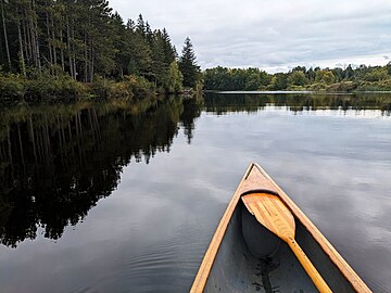
[edit]In its upper reaches is a region of mostly flat water and lakes. The river has more than three dozen source lakes and ponds north of Upper Saranac Lake; the highest is Mountain Pond on Long Pond Mountain. In the last third of its length it drops two-thirds of its total drop, and is known for having navigable rapids, which make it a popular site forwhitewaterkayakingandcanoeing.[4]
The Saranac River empties intoLake Champlainat theCity of PlattsburghinClinton County, New York.The river flows in a northeasterly direction from theAdirondack Mountains.[5]
The river encompassesUpper,MiddleandLower Saranac Lakes,as well asOseetah Lake,Lake Flower,Franklin Falls PondandUnion Falls Pond,and flows through the village ofSaranac Lake;there arelocksbetween Middle and Lower Saranac Lakes and between Lower Saranac and Oseetah, although the drop is only a few feet. Thirty-three miles further northeast, the river flows through the Town ofSaranac,before winding through Plattsburgh, reaching Lake Champlain after a further 23 miles.
Origin of name
[edit]The name of the river is from theAbenakiwordzalônák:tégw,composed of the free noun rootzalôn,meaning "staghorn sumaccone ";-ak,the Abenaki plural suffix for nouns of the animatenoun class;and the bound noun root (i.e., suffix)-tégw,meaning "river."[1]Other names for the river are Riviere Saint Amant, Riviere Saint Arnont, Riviere Salasanac, Sal-a-sa-nac and Salasance.[2]
Fishery
[edit]The Saranac River has a fairly diverse fishery, includingnorthern pike,largemouth bass,smallmouth bass,rock bass,pumpkinseed,fallfish,brown bullhead,brown trout,and landlockedatlantic salmon.
Tourist attractions
[edit]The river is also part of the 740-mileNorthern Forest Canoe Trail,which begins inOld Forge, NYand ends inFort Kent, ME.
See also
[edit]Gallery
[edit]-
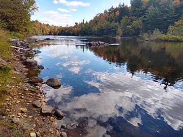
 Permanent Rapids on the Saranac River, Adirondack Mountains, New York State, USA
 -
 Franklin Falls in the Spring
 -
 A small island in Middle Saranac Lake,Stony Creek Mountainbehind
 -
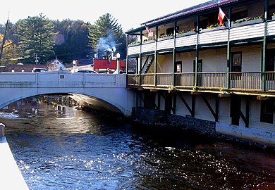 The river passes throughSaranac Lake
 -
 The Saranac River in Clinton County, NY
 -
 Saranac River near Redford, NY


References
[edit]- ^abDay, pp. 248-249.
- ^ab"Saranac River".Geographic Names Information System.United States Geological Survey,United States Department of the Interior.Retrieved2019-01-08.
- ^"The National Map".U.S. Geological Survey.RetrievedFeb 11,2011.
- ^Jamieson, Paul and Morris, Donald,Adirondack Canoe Waters, North Flow,Lake George, NY: Adirondack Mountain Club, 1987.ISBN0-935272-43-7.
- ^Day, Gordon M. "Abenaki Place Names in the Champlain Valley." In Foster, Michael K. and Cowan, William, eds.,In Search of New England's Native Past: Selected Essays by Gordon M. Day,pp. 229–262, Amherst, MA: University of Massachusetts Press, 1998.ISBN1-558491-50-3.