
Sawyers Bar, California
Sawyers Bar | |
|---|---|
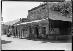 Store buildings in Sawyers Bar, 1937 | |
 Sawyers Bar Location in California  Sawyers Bar Sawyers Bar (the United States) | |
| Coordinates:41°17′50.64″N123°7′49.08″W/ 41.2974000°N 123.1303000°W | |
| Country | United States |
| State | California |
| County | Siskiyou County |
| Elevation | 2,247 ft (685 m) |
Sawyers Baris anunincorporated communitylocated on theNorth Fork Salmon Riverin unincorporatedSiskiyou County, California,not to be confused with a Sawyers orLawyers Barin Del Norte County.[2]
History[edit]
Sawyers Bar, now in Siskiyou County was aCalifornia Gold Rushmining camp, first inTrinity County(one of the original counties of California, created in 1850 at the time of statehood). Then following the rush to the Klamath and Salmon Rivers, it became part of the now defunctKlamath Countyfrom 1851 to 1874. It was then within that part of Klamath County annexed to Siskiyou County. Sawyers Bar, was one of the largest gold producers in the county that year, along withNegro Flat,Gullion's BarandBestville.[3]Currently, Sawyers Bar has a population of about 20 permanent residents and about 34 during the summer.
Climate[edit]
| Climate data for Sawyers Bar Ranger Station, California, 1931–2016 | |||||||||||||
|---|---|---|---|---|---|---|---|---|---|---|---|---|---|
| Month | Jan | Feb | Mar | Apr | May | Jun | Jul | Aug | Sep | Oct | Nov | Dec | Year |
| Record high °F (°C) | 74 (23) |
82 (28) |
90 (32) |
100 (38) |
109 (43) |
111 (44) |
118 (48) |
115 (46) |
112 (44) |
110 (43) |
80 (27) |
67 (19) |
118 (48) |
| Mean daily maximum °F (°C) | 47.8 (8.8) |
53.2 (11.8) |
56.4 (13.6) |
63.8 (17.7) |
74.5 (23.6) |
82.2 (27.9) |
91.9 (33.3) |
91.0 (32.8) |
84.5 (29.2) |
71.2 (21.8) |
54.7 (12.6) |
46.2 (7.9) |
68.1 (20.1) |
| Mean daily minimum °F (°C) | 28.0 (−2.2) |
29.7 (−1.3) |
32.1 (0.1) |
33.3 (0.7) |
39.6 (4.2) |
47.4 (8.6) |
52.7 (11.5) |
52.0 (11.1) |
46.6 (8.1) |
38.7 (3.7) |
32.8 (0.4) |
28.0 (−2.2) |
38.4 (3.6) |
| Record low °F (°C) | 2 (−17) |
11 (−12) |
19 (−7) |
21 (−6) |
25 (−4) |
27 (−3) |
30 (−1) |
36 (2) |
27 (−3) |
23 (−5) |
15 (−9) |
−4 (−20) |
−4 (−20) |
| Averageprecipitationinches (mm) | 8.38 (213) |
5.62 (143) |
5.25 (133) |
2.22 (56) |
1.55 (39) |
0.97 (25) |
0.26 (6.6) |
0.57 (14) |
0.90 (23) |
3.78 (96) |
6.63 (168) |
8.15 (207) |
44.28 (1,125) |
| Average snowfall inches (cm) | 11.9 (30) |
4.1 (10) |
4.3 (11) |
0.2 (0.51) |
0.1 (0.25) |
0.0 (0.0) |
0.0 (0.0) |
0.0 (0.0) |
0.0 (0.0) |
0.0 (0.0) |
1.6 (4.1) |
5.4 (14) |
27.6 (69.86) |
| Average precipitation days(≥ 0.01 in) | 12 | 11 | 12 | 9 | 6 | 4 | 1 | 2 | 3 | 7 | 11 | 12 | 91 |
| Source: WRCC[4] | |||||||||||||
See also[edit]
References[edit]
- ^U.S. Geological Survey Geographic Names Information System: Sawyers Bar, California
- ^GNIS Feature Detail Report for: Sawyers Bar
- ^Hubert Howe Bancroft, History of California, Vol. VI, 1848-1859, The History company, San Francisco, 1888, p.370
- ^ "SAWYERS BAR RS, CALIFORNIA (048025)".Western Regional Climate Center.RetrievedOctober 11,2022.
41°17′51″N123°07′49″W/ 41.2974°N 123.1303°W
Municipalities and communities ofSiskiyou County, California,United States | ||
|---|---|---|
| Cities |  | |
| CDPs | ||
| Unincorporated communities | ||
| Indian reservation | ||
| Ghost towns | ||
| Footnotes | ‡This populated place also has portions in an adjacent county or counties | |
ThisSiskiyou County, California-related article is astub.You can help Wikipedia byexpanding it. |