
Schaan
This articleneeds additional citations forverification.(August 2010) |
You can helpexpand this article with text translated fromthe corresponding articlein German.(January 2015)Click [show] for important translation instructions.
|
Schaan | |
|---|---|
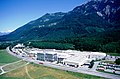
   Top to bottom: View fromTriesenbergwith Schaan on the bottom right, city center, St. Laurentius Parish Church | |
 Flag  Coat of arms | |
Location of Schaan  | |
 Schaan and its exclaves in Liechtenstein | |
| Coordinates:47°10′00″N9°30′35″E/ 47.16667°N 9.50972°E | |
| Country | |
| Electoral district | Oberland |
| Villages | none |
| Area | |
| • Total | 26.92 km2(10.39 sq mi) |
| Elevation | 450 m (1,480 ft) |
| Population (31-12-2019)[1] | |
| • Total | 6,039 |
| • Density | 220/km2(580/sq mi) |
| Time zone | UTC+1(CET) |
| • Summer (DST) | UTC+2(CEST) |
| Postal code | 9494 |
| Area code | 7005 |
| ISO 3166 code | LI-07 |
| Website | www.schaan.li |
Schaan(German pronunciation:[ʃaːn]) is the largestmunicipalityofLiechtensteinby population. It is located to the north ofVaduz,the capital, in the central part of the country. As of 2019[update]it has a population of 6,039,[2]making it the most populous administrative district in Liechtenstein. Representing an important traffic hub and industrial location of the country, Schaan covers an area of 26.92 km2(10.39 sq mi), including mountains and forest. It is a municipality within the electoral district ofOberlandin thePrincipality of Liechtenstein.Schaan contains fourenclaves:Brunnenegg, Gritsch, Guschg, and Plankner Neugrütt.
History[edit]
Recent archaeological finds have shown that Schaan has been inhabited for over 6,000 years: In the year 15 BC, theRomans,underAugustus,conquered the territory of the present Principality of Liechtenstein and established the Roman province ofRaetia.In the 1st century AD, a military road was built fromMilantoBregenz,running along theLuzisteigon the right bank of the Rhine. This led to the building of settlements in modern-day Schaan. In 1887, two Roman legionnaire's helmets were found buried during digging work above Dux. Bearing the engraved names of the legionariesPublius Cavidius FelixandNumerius Pomponiusand dated to the 1st century AD, it is likely that they were intended as a variety of commemoration of the two men. They are now housed in the museums of Bregenz and Zurich.
The most important Roman building on the territory of the municipality is a fort built in the valley, whose purpose was to afford protection against the ever more frequentAlemannicinvasions. Remains of its foundations and the gate tower are again visible from St. Peter's Church, Schaan. A 5th century baptistery was found during excavations inside this church, suggesting early Christianization. During excavations there, traces of a prehistoric settlement were also found.
The Alemannic settlement is evidenced by numerous grave finds. At that time Schaan consisted of two separate parts. The Romanized Räter-people had their centre at St. Peter, while the Alemannic population settled in the area of Specki. This dichotomy can still be seen today in the existence of two alpine cooperatives, the North-Alemannic cooperative Gritsch and the southern Rhaeto-Roman cooperative Guschg.
Administration[edit]
Schaan is locally administered by the mayor and a 13-person municipal council, elected every four years since 1975. The incumbent mayor isDaniel Hilti,since 2003.[3]
List of mayors (1864–present)[edit]
| Name | Term | Party | Ref(s). | |
|---|---|---|---|---|
| Johann Quaderer | 1864–1870 | —
|
||
| Ferdinand Walser | 1870–1873 | |||
| Jakob Wagner | 1873–1876 | |||
| Josef Tschetter | 1876–1879 | |||
| Ferdinand Walser | 1879–1880 | |||
| Julius Wagner | 1880–1884 | |||
| Josef Tschetter | 1884–1888 | |||
| Josef Beck | 1888–1894 | |||
| Ferdinand Walser | 1894–1900 | |||
| Jakob Falk | 1900–1903 | |||
| Ferdinand Walser | 1903–1909 | |||
| Fritz Walser | 1909–1912 | |||
| Josef Beck | 1912–1915 | |||
| Fritz Walser | 1915–1918 | |||
| Edmund Risch | 1918–1924 | FBP | ||
| Johann Hilti | 1924–1927 | |||
| Ferdinand Risch | 1927–1940 | |||
| Josef Schierscher | 1940–1942 | |||
| Tobias Jehle | 1942–1957 | |||
| Ludwig Beck | 1957–1969 | VU | ||
| Walter Beck | 1969–1979 | FBP | ||
| Lorenz Schierscher | 1979–1991 | |||
| Hansjakob Falk | 1991–2003 | |||
| Daniel Hilti | 2003–present | VU | ||
Geography[edit]
Schaan is the northernmost municipality in the Liechtenstein Oberland. It is bordered to the south by the capital,Vaduz,to the east byPlankenandTriesenberg,and to the north by the municipalities ofEschenandGamprin.In the west, theRhineforms the natural border withSwitzerland,and in the east, the town is dominated by the Three Sisters mountain range. Schaan also has four exclaves within other municipalities, and two enclaves within its primary municipality. Because of this, Schaan bordersAustriain three separate locations.
Transport[edit]
Schaan-Vaduz railway station[edit]
Schaan-Vaduzis one of the four train stations servingLiechtenstein,located in the town of Schaan, 3.5 km fromVaduz.It is owned by theAustrian Federal Railways(ÖBB). The station is served by eighteen trains per day, nine in each direction between Switzerland and Austria. It is situated on the international and electrifiedFeldkirch-Buchsline, between the station ofBuchs SG(inSwitzerland) and the stop ofForst Hilti(in the northern suburb of Schaan). It is served only by regional trains.
Schaan Forst Hilti railway station[edit]
Thestationis served by eighteen trains per day, nine in each direction between Switzerland and Austria. It is located in front of theHilti Corporation's headquarters, on the outskirts of Schaan.
Climate[edit]
Schaan has anOceanic climate(Koppen:Cfb)
| Climate data for Schaan | |||||||||||||
|---|---|---|---|---|---|---|---|---|---|---|---|---|---|
| Month | Jan | Feb | Mar | Apr | May | Jun | Jul | Aug | Sep | Oct | Nov | Dec | Year |
| Mean daily maximum °C (°F) | 2.6 (36.7) |
4.8 (40.6) |
9.5 (49.1) |
13.8 (56.8) |
18.1 (64.6) |
21.3 (70.3) |
23.4 (74.1) |
22.5 (72.5) |
19.7 (67.5) |
14.1 (57.4) |
8.1 (46.6) |
3.4 (38.1) |
13.4 (56.1) |
| Daily mean °C (°F) | −0.6 (30.9) |
1.1 (34.0) |
4.9 (40.8) |
8.8 (47.8) |
12.9 (55.2) |
16.2 (61.2) |
18.3 (64.9) |
17.6 (63.7) |
14.8 (58.6) |
9.8 (49.6) |
4.6 (40.3) |
0.4 (32.7) |
9.1 (48.4) |
| Mean daily minimum °C (°F) | −3.7 (25.3) |
−2.6 (27.3) |
0.4 (32.7) |
3.9 (39.0) |
7.8 (46.0) |
11.2 (52.2) |
13.2 (55.8) |
12.7 (54.9) |
10.0 (50.0) |
5.6 (42.1) |
1.1 (34.0) |
−2.5 (27.5) |
4.8 (40.6) |
| Averageprecipitationmm (inches) | 67 (2.6) |
62 (2.4) |
65 (2.6) |
87 (3.4) |
106 (4.2) |
132 (5.2) |
130 (5.1) |
140 (5.5) |
103 (4.1) |
76 (3.0) |
79 (3.1) |
76 (3.0) |
1,123 (44.2) |
| Source: Climate-data.org[4] | |||||||||||||
Education[edit]
There are four kindergarten sites: Malarsch, Pardiel, Rebera, and Werkof. The Gemeinschaftszentrum Resch, Primarschule provides primary education.[5]
RealschuleSchaan and Sportschule Liechtenstein are in Schaan, while Realschule Vaduz andOberschuleVaduz are in theSchulzentrum Mühleholz IIin Vaduz.Liechtensteinisches Gymnasiumis also in Vaduz.[6]
There is a privateWaldorfschool which has students from, in addition to Liechtenstein, Austria and Switzerland. It was established in 1985.[7]
Notable people[edit]
- Maria von Linden(1869–1936), German bacteriologist and zoologist
- Gerta Keller(born 1945, Schaan), Professor of Paleontology and Geology atPrinceton Universitysince 1984.[8]
- Roman Hermann(born 1953, Schaan), Liechtensteiner former cyclist
- Paul Frommelt(born 1957, Schaan), retired Alpine skier
- Peter Jehle(born 1982, Schaan), footballer who plays for Liechtenstein clubFC Vaduzas a goalkeeper
- Ivan Quintans(born 1989, Schaan), a Liechtensteiner footballer
Gallery[edit]
-
 Schaantown hall
 -

-
 Schaan–Buchs bridge, the only railway bridge between Liechtenstein and Switzerland
 -
 Headquarters ofHilti


References[edit]
- ^"LLV".Llv.li.Retrieved27 January2022.
- ^"Bevölkerungsstatistik"(PDF).Llv.li.June 30, 2017.RetrievedJanuary 27,2022.
- ^abMayr, Ulrike;Quaderer, Rupert;Frommelt, Fabian (31 December 2011)."Schaan".Historisches Lexikon des Fürstentums Liechtenstein(in German).Retrieved23 May2024.
- ^ "Climate: Schaan, LI".Climate-data.org.
- ^"Strassenplan"(Archive). Commune of Schaan. Retrieved on May 12, 2016.
- ^"Weiterführende Schulen Schaan."Commune of Schaan. Retrieved on May 12, 2016." Realschule Schaan Duxgass 55 9494 Schaan "and" Sportschule Liechtenstein Duxgass 55 9494 Schaan "and" Realschule Vaduz Schulzentrum Mühleholz II 9490 Vaduz "and" Oberschule Vaduz Schulzentrum Mühleholz II 9490 Vaduz "
- ^"Waldorfschule."Commune of Schaan. Retrieved on May 12, 2016.
- ^"Gerta Keller, Professor of Geosciences, Emeritus | Volcanism, Impacts and Mass Extinctions".Gkeller.princeton.edu.
External links[edit]
| International | |
|---|---|
| National | |
| Geographic | |
| Other | |