
Seine-Maritime
Seine-Maritime | |
|---|---|
 Prefecturebuilding of the Seine-Maritime department, in Rouen | |
 Flag  Coat of arms | |
 Location of Seine-Maritime in France | |
| Coordinates:49°40′N0°50′E/ 49.667°N 0.833°E | |
| Country | France |
| Region | Normandy |
| Prefecture | Rouen |
| Subprefectures | Dieppe Le Havre |
| Government | |
| •President of the Departmental Council | Bertrand Bellanger[1] |
| Area | |
| • Total | 6,278 km2(2,424 sq mi) |
| Population (2021)[2] | |
| • Total | 1,255,918 |
| • Rank | 16th |
| • Density | 200/km2(520/sq mi) |
| Time zone | UTC+1(CET) |
| • Summer (DST) | UTC+2(CEST) |
| ISO 3166 code | FR-76 |
| Department number | 76 |
| Arrondissements | 3 |
| Cantons | 35 |
| Communes | 708 |
| ^1French Land Register data, which excludeestuaries,and lakes, ponds, and glaciers larger than 1 km2 | |
Seine-Maritime(French pronunciation:[sɛnmaʁitim]) is adepartment of Francein theNormandyregionof northernFrance.It is situated on the northern coast of France, at the mouth of theSeine,and includes the cities ofRouenandLe Havre.Until 1955 it was namedSeine-Inférieure.It had a population of 1,255,633 in 2019.[3]
History[edit]
- 1790 - Creation of the Seine-Inférieure department
- The department was created from part of theold provinceofNormandyduring theFrench Revolution,on 4 March 1790, through the application of a law of 22 December 1789.
- 1815 - Occupation
- After the victory atWaterlooof the coalition armies, the department was occupied byBritishforcesfrom June 1815 till November 1818.
- 1843 – Railways and industry
- In Rouen, Elbeuf, andBolbec,the number of textile factories is increasing. Metallurgy and naval construction as well.
- 1851 - A republican department
- Following PresidentLouis-Napoléon Bonaparte's1851 Coup d'état,Seine-Inférieure was one of several departments placed under a state of emergency (literally, in French,state of siege)[4]following fears of significant resistance to the new government.
- World War II
- In 1942, during occupation byNazi Germany,twoAlliedraids, theBrunevalandDieppe,took place at towns of the channel coast of Seine-Inférieure.
- 1955 - Rename to Seine-Maritime
In 1955, the department's name was officially changed to Seine-Maritime.
Heraldry[edit]
|
The arms of the departement Seine-Maritime are blazoned: Gules a fess wavy argent between two lions passant gardant or armed and langued azure.
|
Geography[edit]
The department can be split into three main areas:[5]
- TheSeine valley.The Seine flows through the provincial capitalRouen.
- The chalk plateauPays de Caux,with its abrupt coastline (theAlabaster Coast).
- The NormanPays de Bray,with its hills andbocagelandscape.
Administration[edit]
The département was created in 1790 as Seine-Inférieure, one of five departements that replaced the formerprovinceofNormandy.In 1800 fivearrondissementswere created within the département, namelyRouen,Le Havre,Dieppe,NeufchatelandYvetot,although the latter two were disbanded in 1926. On 18 January 1955 the name of the département was changed to Seine-Maritime, in order to provide a more positive-sounding name and in-keeping with changes made in a number of other French departements.
Principal towns[edit]
The most populous commune isLe Havre;the prefectureRouenis the second-most populous. As of 2019, there are 7 communes with more than 20,000 inhabitants:[3]
| Commune | Population (2019) |
|---|---|
| Le Havre | 168,290 |
| Rouen | 112,321 |
| Sotteville-lès-Rouen | 29,068 |
| Saint-Étienne-du-Rouvray | 28,352 |
| Dieppe | 28,241 |
| Le Grand-Quevilly | 25,963 |
| Le Petit-Quevilly | 22,000 |
Demographics[edit]
|
| |||||||||||||||||||||||||||||||||||||||||||||||||||||||||||||||||||||||||||||||||
| ||||||||||||||||||||||||||||||||||||||||||||||||||||||||||||||||||||||||||||||||||
| source:[6][7] | ||||||||||||||||||||||||||||||||||||||||||||||||||||||||||||||||||||||||||||||||||
Previously lacking a demonym, the inhabitants of Seine-Maritime (as the department had been renamed in 1955) chose, following a public consultation, to be identified in official documents as "Seinomarins"[8](males) and "Seinomarines" (females).
Politics[edit]
The president of the Departmental Council is Bertrand Bellanger, elected in 2019.
Presidential elections 2nd round[edit]
| Election | Winning Candidate | Party | % | 2nd Place Candidate | Party | % | |
|---|---|---|---|---|---|---|---|
| 2022 | Emmanuel Macron | LREM | 55.28 | Marine Le Pen | FN | 44.72 | |
| 2017[9] | Emmanuel Macron | LREM | 60.42 | Marine Le Pen | FN | 39.58 | |
| 2012 | François Hollande | PS | 54.94 | Nicolas Sarkozy | UMP | 45.06 | |
| 2007 | Nicolas Sarkozy | UMP | 50.20 | Ségolène Royal | PS | 49.80 | |
| 2002[9] | Jacques Chirac | RPR | 82.58 | Jean-Marie Le Pen | FN | 17.42 | |
Current National Assembly Representatives[edit]
Transport[edit]
In 1843 the railway fromParisreached the region. The département is connected to the adjacentEuredepartment via theTancarvilleandPont de Normandiebridge crossings of theSeine.
Culture[edit]
Madame BovarybyGustave Flaubertis set in Seine Maritime.
The novelLa PlacebyAnnie Ernauxlargely takes place in Seine-Maritime and describes events and changes that take place in relation to French society in the 20th century especially in relation to the rural population.
The first story of the long-running seriesValérian and Laurelineis set in Seine-Maritime, with the character Laureline originating from the area.
Cauchoisis the dialect of the Pays de Caux, and is one of the most vibrant forms of theNorman languagebeyondCotentinais.
Tourism[edit]
-

-
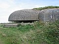 Element of theAtlantic WallnearFécamp
 -

-
 Limestone cliffs ofÉtretat


See also[edit]
- Arrondissements of the Seine-Maritime department
- Cantons of the Seine-Maritime department
- Communauté de communes d'Yères et Plateaux
- Communes of the Seine-Maritime department
References[edit]
- ^"Répertoire national des élus: les conseillers départementaux".data.gouv.fr, Plateforme ouverte des données publiques françaises(in French). 4 May 2022.
- ^"Téléchargement du fichier d'ensemble des populations légales en 2021"(in French).The National Institute of Statistics and Economic Studies.28 December 2023.
- ^abPopulations légales 2019: 76 Seine-Maritime,INSEE
- ^Jacques Olivier Boudon,Les Bonaparte: regards sur la France impériale.La Documentation photographique, dossier 8073, janvier-février 2010, p. 11 (carte deGilles Pécout)
- ^"Seine Maritime".France-For-Visitors.com.Rough Guides.Retrieved22 October2011.
- ^"Historique de la Seine-Maritime".Le SPLAF.
- ^"Évolution et structure de la population en 2016".INSEE.
- ^"Seinomarins, un beau nom!".Commune76.
- ^abl'Intérieur, Ministère de."Présidentielles".interieur.gouv.fr.
- ^Nationale, Assemblée."Assemblée nationale ~ Les députés, le vote de la loi, le Parlement français".Assemblée nationale.
External links[edit]
- (in French)Departmental Council website
- (in French)Prefecture website
- (in French)Communes 76
| International | |
|---|---|
| National | |
| Geographic | |
| Other | |