
Selçuklu
Selçuklu | |
|---|---|
 | |
 Logo | |
 Map showing Selçuklu District in Konya Province | |
 Selçuklu Location in Turkey  Selçuklu Selçuklu (Turkey Central Anatolia) | |
| Coordinates:37°52′53″N32°29′32″E/ 37.88139°N 32.49222°E | |
| Country | Turkey |
| Province | Konya |
| Government | |
| • Mayor | Ahmet Pekyatırmacı (AKP) |
| Area | 1,931 km2(746 sq mi) |
| Elevation | 1,020 m (3,350 ft) |
| Population (2022)[1] | 690,667 |
| • Density | 360/km2(930/sq mi) |
| Time zone | UTC+3(TRT) |
| Area code | 0332 |
| Website | www |
Selçukluis a municipality anddistrictofKonya Province,Turkey.[2]Its area is 1,931 km2,[3]and its population is 690,667 (2022).[1]Selçuklu is one of the central districts ofKonya,along with the districts ofKaratayandMeram.It covers the northwestern part of the agglomeration of Konya and the adjacent countryside.
Flora
[edit]Between 2004 and 2006, a study was carried out of plants in the district in the area of the Başarakavak and Tatköy neighborhoods, and the Altınapa Dam. Two species are listed as 'Endangered' according to theIUCN Red List:Clypeola ciliata(Boiss) andSilene lycaonica(Chowdh). Also listed as 'Vulnerable' wereIris stenophyllaandCentaurea bourgaei(Boiss).[4][5]
Places to see
[edit]TheKonya Tropical Butterfly Garden,opened in 2015, is a major tourist attraction.[6]
Composition
[edit]There are 73neighbourhoodsin Selçuklu District:[7]
- Akademi
- Akıncılar
- Akpınar
- Akşemsettin
- Ardıçlı
- Aşağıpınarbaşı-Bucak
- Aydınlıkevler
- Bağrıkurt
- Başarakavak
- Bedir
- Beyhekim
- Biçer
- Bilecik
- Binkonutlar
- Bosnahersek
- Buhara
- Büyükkayacık
- Çaldere
- Çaltı
- Çandır
- Cumhuriyet
- Dağdere
- Dokuz
- Dumlupınar
- Eğribayat
- Erenköy
- Esenler
- Fatih
- Ferhuniye
- Feritpaşa
- Güvenç
- Hacıkaymak
- Hanaybaşı
- Hocacihan
- Horozluhan
- Hüsamettinçelebi
- İhsaniye
- Işıklar
- Kaleköy
- Karaömerler
- Kervan
- Kılınçaslan
- Kınık
- Kızılcakuyu
- Kosova
- Küçükmuhsine
- Malazgirt
- Mehmet Akif
- Merkez
- Meydanköy
- Musalla Bağları
- Nişantaş
- Parsana
- Sakarya
- Sancak
- Sarayköy
- Sarıcalar
- Şeker
- Selahaddini Eyyubi
- Selahattin
- Selçuk
- Şeyhşamil
- Sille
- Sille Ak
- Sızma
- Sulutaş
- Tatköy
- Tepekent
- Tömek
- Ulumuhsine
- Yazıbelen
- Yazır
- Yukarıpınarbaşı
Gallery
[edit]-
 Altınapa Reservoir, western are of Selçuklu with the Altınapa Han (see red arrow)
 -
 Dokuzun Hanı; view to the nord.
 -
 Entrance of Horuzlu Han; view from the south.
 -
 Zazadin Han near Tömek.
 -
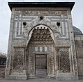
 Alâeddin Mosque; built from 1155 to 1221.
 -
 Karatay Medresesi Museum.
 -
 The Selçuklu Kulesi (Tower)


References
[edit]- ^ab"Address-based population registration system (ADNKS) results dated 31 December 2022, Favorite Reports"(XLS).TÜİK.Retrieved19 September2023.
- ^Büyükşehir İlçe Belediyesi,Turkey Civil Administration Departments Inventory. Retrieved 19 September 2023.
- ^"İl ve İlçe Yüz ölçümleri".General Directorate of Mapping.Retrieved19 September2023.
- ^Stephan Robbert Gradstein (editor)Programme and Abstracts: Göttingen, 7–11 April 2008atGoogle Books
- ^Yildiztugay, Evren; Bağci, Yavuz; Küçüködük, Mustafa."Endemic plants of Başarakavak and environs (Konya, Turkey)"(pdf).botanicaserbica.bio.bg.ac.rs (Botanica Serbia).Retrieved16 October2014.
- ^"Başbakan Ahmet Davutoğlu Tropikal Kelebek Bahçesi'ni açtı".Hürriyet(in Turkish). 4 July 2015.Retrieved21 January2019.
- ^Mahalle,Turkey Civil Administration Departments Inventory. Retrieved 19 September 2023.
External links
[edit]- District governor's official website(in Turkish)
- District municipality's official website(in Turkish)
- Turkish Ministry of Education."Statistical information on Selçuklu, Turkey"(in Turkish). Archived fromthe originalon 2011-10-03.


This geographical article about a location inKonya Province,Turkeyis astub.You can help Wikipedia byexpanding it. |