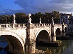
Severan Bridge
Severan Bridge | |
|---|---|
 Severan Bridge with the columns of Roman EmperorLucius Septimius Severusand his second wifeJulia Domnaseen from the south. | |
| Coordinates | 37°55′58″N38°36′31″E/ 37.9328°N 38.6085°E |
| Carries | Road traffic and pedestrians |
| Crosses | Chabinas Creek(Cendere Çayı) |
| Locale | BetweenKahtaandSincikinAdıyaman Province,Turkey |
| Official name | Cendere Köprüsü |
| Characteristics | |
| Design | Simple, unadorned, single majesticarch |
| Total length | 120 m (390 ft) |
| Width | 7 m (23 ft) |
| Longest span | 34.2 m (112 ft) |
| History | |
| Construction end | c200[1] |
| Location | |
 | |
TheSeveran Bridge(also known asChabinas BridgeorCendere BridgeorSeptimius Severus Bridge;Turkish:Cendere Köprüsü) is a lateRoman bridgelocated near the ancient city ofArsameia(todayEskikale), 55 km (34 mi) north east ofAdıyamanin southeasternTurkey.It spans theCendere Çayı(Chabinas Creek), a tributary ofKâhta Creek,on provincial road 02-03 fromKâhtatoSincikinAdıyaman Province.This bridge was described and pictured in 1883 by archeologistsOsman Hamdi BeyandOsgan Efendi.[2]It has a photo and description inDavid George Hogarth's Wandering Scholar.[3]
Description and history[edit]
The bridge is constructed as a simple, unadorned, singlearchon two rocks at the narrowest point of the creek. At 34.2 m (112 ft) clear span, the structure is quite possibly the second largest extant Roman arch bridge. It is 120 m (390 ft) long and 7 m (23 ft) wide.[4]

The bridge was rebuilt by theLegio XVIGallica,garrisonedin the ancient city ofSamosata(todaySamsat) to begin a war withParthia.Commageneancities built fourCorinthian columnson the bridge, in honor of theRoman EmperorLucius Septimius Severus(193–211), his second wifeJulia Domna,and their sonsCaracallaandPublius Septimius Getaas stated on theinscriptioninLatinon the bridge.[5]Two columns on the Kâhta side are dedicated to Septimius Severus himself and his wife, and two more on the Sincik side are dedicated to Caracalla and Geta, all in 9–10 m in height. Geta's column, however, was removed after his assassination by his brother Caracalla, whodamned Geta's memoryand ordered his name to be removed from all inscriptions.
The Severan Bridge is situated within one of the most importantnational parksin Turkey, which containsNemrut Dağıwith the famous remains of Commagene civilization on top, declared asWorld Cultural Heritage sitebyUNESCO.In 1997, the bridge was restored. Vehicular traffic was restricted to 5 tons or less. The bridge is now closed to vehicles, and a new road bridge has been built 500 m (550 yd) east of the old bridge.[4]
See also[edit]
Notes[edit]
- ^J. B. Leaning, "The Date of the Repair of the Bridge over the River Chabina: L. Alfenus Senecio and L. Marius Perpetuus in Syria Coele",Latomus30:2:386-389 (April–June 1971)JSTOR41527947
- ^(in French)Edhem Eldem,Le voyage à Nemrud Dağı d'Osman Hamdi Bey et Osgan Efendi (1883). Récit de voyage et photographies publiés et annotés,Istanbul, Institut Français d'Études Anatoliennes-Georges Dumézil, 2010. 144 pages[1],pp. 10, 12, 59, 63, picture p. 109
- ^—— (1896).A wandering scholar in the Levant.London: J. Murray.Chapter 4, a description of an 1894 visit.
- ^abDescription of the Severan BridgeRetrieved 22 July 2023.
- ^InscriptionsCILIII, 06709etCILIII, 06710
Further reading[edit]
- O’Connor, Colin (1993),Roman Bridges,Cambridge University Press, pp. 127–129 (E36),ISBN0-521-39326-4
- Galliazzo, Vittorio (1994),I ponti romani. Catalogo generale,vol. 2, Treviso: Edizioni Canova, pp. 390–394 (No. 824),ISBN88-85066-66-6
External links[edit]
- Cendere BridgeatStructurae
- Livius.org: Cendere bridge
- Traianus– Technical investigation of Roman public works

