
Siekierki
Siekierki | |
|---|---|
 | |
 Location withinMokotówdistrict | |
| Coordinates:52°12′30″N21°05′01″E/ 52.208211°N 21.083528°E | |
| Country | |
| Voivodeship | Masovian |
| City | Warsaw |
| District | Mokotów |
| Incorporated | 1916 |
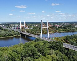
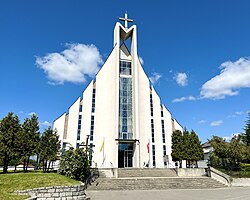
| Notable landmarks | Siekierkowski Bridge,Space Research Center,Marian sanctuary |
| Time zone | UTC+1(CET) |
| • Summer (DST) | UTC+2(CEST) |
| Area code | +48 22 |
Siekierki(Polish pronunciation:[ɕɛˈkʲɛrkʲi],literallylittle axes) is a low-rise housing residential neighborhood inWarsaw,the northeastern part of theMokotówdistrict belonging to Lower Mokotów, adjacent to theVistulariver. The area is home to anastronomical research centerof thePolish Academy of Sciencesand a Marian sanctuary.
History
[edit]The earliest known settlement in the present-day Siekierki area, formerly known asKępa Bełt,was the village of Czarnów, known since the 13th century and situated along the Wilanówka River, which then flowed into the Vistula.[1]A village named Siekierki emerged later on, being mentioned since the 16th century.[2]In the 17th century, the settlement came into the possession ofStanisław Herakliusz Lubomirski,who ordered construction of a recreational pavilion. In the 18th century, the surrounding area was leased byPolish kingAugustus II the Strongfor hunting purposes.[3]In the 19th century, the village consisted of two parts, namelySiekierki WielkieandSiekierki Małe(PolishforGreater SiekierkiandSmaller Siekierki), the joint population of which totalled 194 residents in 30 households by 1827, having increased to 358 residents by 1889. The entire village was an integral part of a local manor's agricultural estate (folwark), which in 1884 covered an area of 556morgen(equivalent to 3.11 km2or 1.2 sq mi), mostly consisting of meadows and pastures.[4]
The village of Siekierki, belonging to theWilanówgminaat the time, was incorporated into the city ofWarsawon April 8, 1916 by a decree ofHans von Beseler,along with the rest ofMokotów.[5]In 1926, afloodbankalong the left bank of the Vistula was completed, mitigating the previously threatening flood hazard and facilitating further development.[3]During theinterwar period,the area was designated for the establishment of an "Olympic District", i.e. anOlympicsports complex covering approximately 160 hectares (400 acres), including a stadium and a rowing course. The project never materialized due to the outbreak ofWorld War II.[6]
During theGerman occupation,Siekierki became site to the onlyprivate revelationin the history of Warsaw, as a local girl Władysława Papis claimed to have experienced apparitions ofVirgin Maryrepeatedly between 1943 and 1949, giving rise to a localMarian worship.[3][7]During theWarsaw Uprisingthe neighbourhood suffered from tragic reprisals against the Polish population as the Nazis carried out mass murders and arsons resulting in majority of buildings being destroyed, including the local manor.[3]
After the war, local residents were officially prohibited from any new construction underBierut Decrees,which contributed significantly to the growth of unauthorized construction.[3]In 1961 theSiekierki Power Station,the largest combined heat and power plant in Poland, was built in the vicinity, although it has later ended up falling within the borders of theAugustówkaarea after the official delineation. In the later period of thePolish People's Republicplans were made to turn Siekierki into ascience parkby constructing a complex of scientific facilities along with corresponding housing developments,[8]however the increasing economic crisis halted the project, the only realized object of which is theastronomical research centerof thePolish Academy of Sciences,completed in 1978.[9]
In 1994 a local Marian sanctuary, commemorating the wartime revelations, was completed, being managed by thePiarist orderever since. In 2002 a nearby expressway and theSiekierkowski Bridgewere opened for use. As part of the EuropeanNatura 2000program, areas of the neighborhood directly adjacent to Vistula were designated as protected landscape in 2004.[10]Between 2005 and 2008 another plans emerged to develop a technology and science park in Siekierki, codenamed "Warsaw Technological Park",[11]however this project was likewise abandoned.[12]
Despite the mentioned unrealized investment plans over the years Siekierki remained an underdeveloped and largely unused area; however, the early 2010s marked the onset of a substantial increase in new residential housing developments. In 2019 the local road network was upgraded due to completion of a new arterial road (Aleja Polski Walczącej), along which an existingtram lineis expected to be extended.[13]Additionally, the plannedMetro LineM3 is to pass through the neighborhood.[14]
Gallery
[edit]-
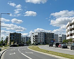 Street in Siekierki
 -
-
-
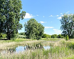
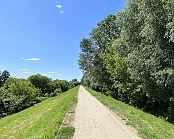 Floodbank by Vistula
 -
-
 Memorial to the localWorld War IIvictims
 -
 Memorial of theFirst Polish Armycrossing Vistula river during theWarsaw Uprising


References
[edit]- ^Wejnert, Aleksander (1850).Opis historyczny trzech kęp na Wiśle pod Warszawą (Polkowska, Bełk, Saska) od najdawniejszych czasów do 1850 r.[Historical description of the three meadows by Vistula near Warsaw (Polkowska, Bełk, Saska) from old times until 1850] (in Polish). Drukarnia Banku Polskiego. pp.18–24.
- ^Encyklopedia Warszawy[Encyclopedia of Warsaw] (in Polish). Warsaw: Polskie Wydawnictwo Naukowe. 1975. p. 571.
- ^abcdeKorzenie Siekierek[Roots of Siekierki] (in Polish). Warsaw: Dom Kultury Dorożkarnia. 2017.
- ^Słownik geograficzny Królestwa Polskiego, t. X: Rukszenice - Sochaczew[Geographical dictionary of the Kingdom of Poland, part 10: Rukszenice - Sochaczew] (in Polish). Warsaw. 1889.
{{cite book}}:CS1 maint: location missing publisher (link)> - ^Nietyksza, Maria; Pruss, Witold (1973).Zmiany w układzie przestrzennym Warszawy. Wielkomiejski rozwój Warszawy do 1918 r.[Changes in the spatial layout of Warsaw. Urban development of Warsaw until 1918] (in Polish). Warsaw: Wydawnictwo Książka i Wiedza. p. 43.
- ^Potrzuski, Kamil (2019)."Dzielnica olimpijska na warszawskich Siekierkach. Losy niezrealizowanego projektu w świetle akt nieruchomości miasta stołecznego Warszawy z lat 30. XX wieku"[The Olympic District in Warsaw's Siekierki. The fate of an unrealized project in light of the real estate records of the City of Warsaw in the 1930s].Rozprawy Naukowe Akademii Wychowania Fizycznego we Wrocławiu(in Polish).65.Wrocław:16–34.
- ^Papis, Eugenia Władysława (2003).Spotkania z Matką Bożą w Warszawie na Siekierkach 1943-2003[Encounters with the Virgin Mary in Warsaw at Siekierki 1943-2003] (in Polish). Warsaw: Sanktuarium Matki Bożej Nauczycielki Młodzieży.ISBN9788390102740.OCLC1003021533.Archived fromthe originalon 2018-12-09.
- ^Krzyżakowa, Krystyna (1987).Warszawa przyszłości [w:] Kalendarz Warszawski'88(in Polish). Warsaw: Krajowa Agencja Wydawnicza. p. 215.ISBN83-03-01684-9.
- ^Jabłoński, Krzysztof (1984).Warszawa: portret miasta[Warsaw: Portrait of the city] (in Polish). Warsaw: Arkady.ISBN83-213-2993-4.
- ^"Warszawski Obszar Chronionego Krajobrazu".warszawa.rdos.gov.pl(in Polish). Regionalna Dyrekcja Ochrony Środowiska w Warszawie.
- ^Wojtczuk, Michał (2009-04-01)."Park technologiczny: Fatamorgana na łąkach"[Technology park: Fata Morgana on the meadows].Gazeta Wyborcza(in Polish).Retrieved2010-01-10.
- ^Kraj, Izabela (2009-04-17)."Koniec marzeń PiS o Dolinie Krzemowej"[The end of Law and Justice's dreams of Silicon Valley].Życie Warszawy(in Polish).Retrieved2010-01-10.
- ^"Nowa ulica na Mokotowie. Już w sobotę kierowcy pojadą" Czerniakowską bis ""[A new street in Mokotów. Starting this Saturday, drivers will travel on 'Czerniakowska bis'.].metrowarszawa.gazeta.pl(in Polish). 2019-01-30.Retrieved2019-02-04.
- ^Urząd m.st. Warszawy (2023-02-13)."Stolica pięciu linii metra"[The capital of five metro lines].um.warszawa.pl/(in Polish).Retrieved2023-02-13.
