
Simeon De Witt
Simeon De Witt | |
|---|---|
 (1804) byEzra Ames | |
| Born | December 25, 1756 |
| Died | December 3, 1834(aged 77) |
| Alma mater | Queen's College |
Simeon De Witt(December 25, 1756 – December 3, 1834) was Geographer and Surveyor General of theContinental Armyduring theAmerican RevolutionandSurveyor General of the State of New Yorkfor the fifty years from 1784 until his death.
Life and career
[edit]De Witt was born inUlster County, New York,[1]one of fourteen children ofphysicianAndries De Witt and Jannetje Vernooy De Witt, both ofDutchancestry.[2]He was the only graduate in the class of 1776 at Queens College – nowRutgers CollegeofRutgers University– inNew Brunswick, New Jersey.After the capture of New Brunswick by theBritishduring the war, De Witt fled toNew York Citywhere he joined the Revolutionary Army.

In June 1778, having been trained as a surveyor byJames Clinton,the husband of De Witt's Aunt Mary, De Witt was appointed as assistant to the Geographer and Surveyor of the Army,Colonel Robert Erskine,and contributed to a number of historically significant maps. After Erskine's death in 1780, De Witt was appointed to his post.[2]
After theAmerican Revolutionary War,De Witt attempted, but failed, to get theContinental Congressinterested in a national mapping project.[1]
De Witt was appointedNew York State Surveyor Generalin 1784, New York being one of the few states which had such an office.[3]De Witt died 50 years later still holding that position, having been re-appointed and re-elected several times. Although he was afirst cousinofDeWitt Clinton– the most powerful politician in the state, and both theMayor of New York Cityand aState Senator– and was aDemocratic-Republican,De Witt was never removed from office. BothFederalistsandBucktailsrecognized his outstanding qualification for the office.
De Witt was elected to theAmerican Philosophical Societyin 1787.[4]
In 1796,George Washingtonfavored De Witt to become the Surveyor General of the United States, but De Witt turned down the nomination. Washington wrote toThomas Jeffersonabout De Witt "I can assure you, he is extremely modest, sensible, sober, discreet, and deserving of favors. He is esteemed a very good mathematician," but despite this praise, none of De Witt's various proposals gained traction during Jefferson's presidency, and De Witt had nothing to do with theLand Ordinance of 1785,despite what some sources claim.[5][6]
De Witt was appointed in 1807 by the state legislature, at the request of theNew York City Common Council,to a three-man commission which was to determine how the city's future streets would be laid out. Frustrated by opposition from landowners, who wanted to determine for themselves where streets would go as they developed their properties, and interference from various political factions, the Council had called on the state for assistance. The Commission was given "exclusive power to lay out streets, roads, and public squares, of such width, extent, and direction, as to them shall seem most conducive to public good, and to shut up, or direct to be shut up, any streets or parts thereof which have been heretofore laid out... [but] not accepted by the Common Council."[7][8][9]The commissioners were authorized to be paid $4 a day for their work (equivalent to $83 in 2023)[10]– although De Witt was the only one who was actually compensated; the other two commissioners,Gouvernor MorrisandJohn Rutherfurd,were rich men and waived their fees. De Witt, however, also wanted additional compensation for the days he spent traveling from his home in Albany to New York City, and for Sundays he was required, because of Commission business, to stay in the city; he was reluctantly given travel payment, but was refused additional payment for his Sundays in New York City.[11]
The result of the work of the commission was theCommissioners' Plan of 1811,which laid out Manhattan's streets above14th Street– and to a certain extent between 14th andHoustonStreets – in a regular rectilineargridironpattern, which has garnered both praise and intense criticism ever since it was presented to the public.[12]
Ironically, considering the massive effect on Manhattan of the Commissioners' Plan, De Witt himself did not much like New York City. He never took up residence there, and seems to have held his time there to a minimum.[11]
In addition to his work on New York City, De Witt laid out rectilinear street grids inAlbany, New York;[13]Ithaca, New York,of which he is considered one of the founders; and on a number of other developments of state-owned land.[3]
From 1810 to 1816, De Witt was also a member of the firstErie Canal Commission,a project dear to the heart of his cousin, De Witt Clinton. He ordered the making of surveys which would prove essential for the eventual building of the canal.[11]

As well as being Surveyor General of New York, from 1829 until his death in 1834, De Witt was theChancellor of the University of the State of New Yorkand thus the head of theBoard of Regents;he had been a Regent since 1798. The Board of Regents is the governing body for theUniversity of the State of New York– not to be confused with theState University of New York– which regulates many public and private institutions in New York State, licensing, accrediting and setting standards for schools operating in New York State, frompre-kindergartenthrough professional andgraduate school,as well as for the practice of a wide variety of professions.
De Witt was often given credit for givingClassicalGreekandRomannames to the twenty-eightcentral New York Military Tracttownshipsthat his office mapped after the war, to be given to veterans in payment for their military service. More recently, credit has been given to his clerkRobert Harpur,apparently a reader of classical literature.[14]
De Witt did not leave much in the way of writings. He wrote a treatise published in 1813 on perspective drawing, and one in 1819 which argued for the establishment of a state agricultural college, and also had some letters published on scientific topics.[11]
New York State map
[edit]In 1802, De Witt produced a detailed map of the state of New York, which was then engraved by Gideon Fairman.[15]The map is said by historianGerard Koeppelto have been "meticulously drawn" and to have "set a standard for American cartography; it is still considered 'the most important map ever made of the Empire State.'"[16]The map shows New York state to be primarily uninhabited, at least as far as white settler go: the map does not indicateNative Americanencampments or lodges.[3]
Personal life
[edit]De Witt was almost six-foot (1.8 m) tall, and was described by his son as having "a noble, serious face, resembling in some respects that of Genl Washington." He was a devout Christian.[3]
De Witt was married three times. In 1789, he married Elizabeth Lynott (1767–1793), the daughter of Thomas and Elizabeth Van Valkenburgh Lynott, and they had two children. In 1799, he married Jane Varick Hardenbergh (d. 1808), the widow of Abraham Hardenbergh (1756–1794), and the sister ofRichard Varick,the longtime mayor of New York City. Their son, Richard Varick De Witt, became a prominentcivil engineer.Later, Simeon marriedSusan Linnin October 1810. Linn was the daughter of the theologianWilliam Linn.The Linns were a literary family: Susan wrote fiction andpoetry,her brotherJohn Blair Linnwas a poet, and her sister, Elizabeth, marriedCharles Brockden Brown,who wrote novels.[11]
De Witt owned a considerable amount of land in theFinger Lakesarea, and held four slaves at his residence inAlbany, New York,but by 1810 he had freed them, a common practice of the area. They continued to work in his household.
De Witt died in Ithaca after having caught a very bad cold while traveling to his various properties in upstate New York.[11]He was buried on his estate in Ithaca, but his remains were subsequently moved toAlbany Rural Cemetery.[2]
Exhibitions and collections
[edit]On May 25, 2010 theSmithsonian InstitutionNational Museum of American Historyexhibited the oldest surviving Anglo-American star map, hand-drawn in 1780 by Simeon De Witt, in itsAlbert H. SmallDocuments Gallery. The map shows the stars visible from De Witt's post in New Jersey. Drawing such a map, as De Witt himself later said, fostered an appreciation of "the ever shifting scenery of the skies and all the gorgeous drapery of heaven." During theRevolutionary War,when cut off from trade with Europe, colonists had to make their own maps; De Witt assisted military geographer and surveyor generalRobert Erskinein drawing the maps needed byGeorge Washington.Also on view are De Witt's drawing instruments and examples of European star maps and astrolabes. The exhibition closed on December 5, 2010. An existing online exhibition offers views of the star map and images of objects in the exhibition.[17]
Portfolio samples
[edit]The following map sections were drawn by, or under the direction of, Simeon De Witt. The originals were not colored as these are.
-
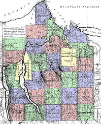 Central New York Military Tract,c. 1792–1793
 -
 Twenty Townships,c. 1792–1793
 -
 Otsego County, New York,c. 1792–1793
 -
 George Croghan's Otsego Patents,c. 1790
 -
 Albany, New York 1790


References
[edit]Notes
- ^abKoeppel (2015), p.78
- ^abcSimeon de Witt,New Netherland Institute
- ^abcdKoeppel (2015), p.79
- ^"Simeon De Witt".American Philosophical Society Member History.American Philosophical Society.Retrieved14 December2020.
- ^Koeppel (2015), pp.78–79
- ^An example of the rectangular grid laid down according to the 1785 law can be found atBallon, Hilary, ed. (2013).The Greatest Grid: The Master Plan of Manhattan 1811-2011.New York:Museum of the City of New YorkandColumbia University Press.p. 52.ISBN978-0-231-15990-6.
- ^Remarks Of The Commissioners For Laying Out Streets And Roads In The City Of New York, Under The Act Of April 3, 1807
- ^Gray, Christopher(October 23, 2005)."Streetscapes: The Commissioners' Plan of 1811: Are Manhattan's Right Angles Wrong?".The New York Times.RetrievedJuly 9,2010.
- ^Burrows, Edwin G.andWallace, Mike(1999).Gotham: A History of New York City to 1898.New York:Oxford University Press.pp. 419–22.ISBN0-195-11634-8.
- ^Koeppel (2015), p.83
- ^abcdefKoeppel (2015), p.80
- ^Koeppel (2015), pp.xix-xxi andpassim
- ^De Witt's map of Albany can be found atBallon, Hilary, ed. (2013).The Greatest Grid: The Master Plan of Manhattan 1811-2011.New York:Museum of the City of New YorkandColumbia University Press.p. 51.ISBN978-0-231-15990-6.
- ^Lemak, Joseph (2008)."Roman Grandeur in Central New York: the Classical Tradition in a Nineteenth-Century Pioneer Town".New York History.89(3): 245. Archived fromthe originalon 2012-04-28.
- ^De Witt, Simeon (1802)."Map of the State of New York".Library of Congress.
- ^Koeppel (2015), p.79, quotingAllen, David Y. (2008),How Simeon De Witt Mapped New York State,New York Map Society
- ^"Cosmos in Miniature: The Remarkable Star Map of Simeon De Witt".National Museum of American History, Smithsonian Institution.Retrieved24 April2012.
Bibliography
- Koeppel, Gerard(2015).City on a Grid: How New York Became New York.Boston:Da Capo Press.ISBN978-0-306-82284-1.
Further reading
- Guthorn, Peter J. (1966).American Maps and Map Makers of the Revolution.Monmouth Beach, New Jersey: Philip Freneau Press.OCLC1019460.
- Ristow, Walter W. (December 1968). "Simeon De Witt / Pioneer American Cartographer".The Canadian Cartographer.5(2): 90–107.doi:10.3138/D235-1057-104G-J643.ISSN0317-7173.
- Schubert, Frank N., ed. (June 1988).The Nation Builders: A Sesquicentennial History of the Corps of Topographical Engineers, 1838–1863.EP 870-1-37. Fort Belvoir, Va.: Office of History, United States Army Corps of Engineers.OCLC17385113.Archived fromthe originalon July 22, 2011.
External links
[edit]- 1802 Map of Central New York
- Biography of Simeon De Witton theNew York State Museumwebsite.
- Franklin and his Friends
- Names of Townships in the Military Tract
- Department of the Geographer to the Army Reenacting Unit, Brigade of the American Revolution
- Hardenbergh family infoat Christ Church Cemetery, Manlius
- De Witt genealogyat Mr. Jumbo
| International | |
|---|---|
| National | |
| Other | |
- 1756 births
- 1834 deaths
- People from Wawarsing, New York
- Military personnel from Albany, New York
- American cartographers
- American people of Dutch descent
- Rutgers University alumni
- Continental Army officers from New York (state)
- Erie Canal Commissioners
- New York State Engineers and Surveyors
- People from Ithaca, New York
- New York (state) Democratic-Republicans
- Central New York
- People from colonial New York
- Clinton family of New York
- Members of the American Philosophical Society
- De Witt family