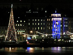
Skeppsbron

Skeppsbron(Swedish:"The Ship's Bridge" ) is both a street and a quay inGamla stan,the old town ofStockholm,capital ofSweden,stretching from the bridgeStrömbronin front of theRoyal Palacesouthward toSlussen.
The quaySkeppsbrokajenruns along the street. Several alleys connects Skeppsbron to the thoroughfareÖsterlånggatan:Slottskajen,Lejonbacken,Slottsbacken,Telegrafgränd,Skeppar Karls Gränd,Bredgränd,Kråkgränd,Nygränd,Brunnsgränd,Skottgränd,Stora Hoparegränd,Drakens Gränd,Ferkens gränd,Gaffelgränd,Johannesgränd,Packhusgränd,Tullgränd,Norra Bankogränd,Södra Bankogränd,Norra Dryckesgränd,Södra Dryckesgränd,Slussplan
History
[edit]
Skeppsbron is mentioned asStadzbronin 1592,skeepzbroonin 1647, and finally appears asSkeppsbronin 1961. While no historical documents knows to tell when or why the decision was taken to develop the eastern waterfront ofStadsholmenin accordance to the pretensions of a nation becoming aGreat Power,it is known this development started during the 1630s and it is generally assumed the plan's originator was KingGustav II Adolf(1594–1632). The new street, built on land created by continuous fillings, was subsequently accrued to the city and old streets stretching fromÖsterlånggatanto the old city wall, were extended down to the new street.[1]
Poles associated with an old quay preceding the existing one have been found some hundred metres from the present quay. It was calledKoggabron(seecog) orstadens allmänningsbro( "the city's common bridge" ).[1]
The stone quay was not completed until 1854 byNils Ericson.Today 'Skeppsbron' refers to the road passing over the quay, while the harbour area outside of it is calledSkeppsbrokajen. [1]
An old fish market, once located between today'sNygrändandBrunnsgränd,was the biggest market place in Gamla stan during the Middle Ages, at the time it was connected directly toStortorget( "The Big Square" ), the central market place, by means ofKöpmangatan( "The Merchant's Street" ). The fish market was scrapped and replaced by a block during the 1520s.[2]
Skeppsbron remained the vital centre for the local shipping business until the early 20th century.[3]ThoughKinnevikhave been furnishing Skeppsbron with one of the world's biggestChristmas treesannually for ten years, Skeppsbron is today crossed by a major traffic route and is mostly sparsely used.[4]Proposals have been brought forward to revitalize the area by adding new shopping areas, residential areas, and ferries.[5]
Prominent buildings and addresses
[edit]
Without a number:Stockholm Palace,and opposite toSlottsbackenthe statue ofGustav III(1746–1792) byTobias Sergel(1740–1814) inaugurated in 1808. It is made in bronze and describes the kings landing on the quay after theRussian war 1788-90.The statue was inspired by theApollo Belvederemarble, and the artist described his work as "is in movement, holding a helm in one hand, while offering an olive branch signifying peace with the other. He wears a navy uniform with a large cape fastened at the left shoulder."[6][7]

N.20,Brandstodsbolagets hus( "House of the Fire-insurance Company" ), designed byIsak Gustaf Clason(1856–1930) and built by the turn of the century 1900 in the style ofTessin the Younger.The exploitation demands of the modern era resulted in the building as being disproportionately large for the setting on its completion, a problem however dissolved by the adoption of its scale by several other buildings along Skeppsbron.[8]ThePhilippine Embassy in Stockholmpreviously occupied the building until it closed in 2012.
N.28,Skeppsbron 28,serves as the headquarters of theYWCA-YMCA of Sweden.
N.42B,Södra Bankohuset( "The Southern Bank Building" ), formerly theBank of Sweden,designed byNicodemus Tessin the Elderand built 1663–1680, rebuilt in 1738 after plans byCarl Hårleman(1700–1753).[3]
N.48,Räntmästartrappan(literally: "Interest Master's Stairs", meaning: "Stairs of the Director of the Financial Administration" ), named after a building once found on the southern corner of Skeppsbron and the stairs leading up to its main entrance. The building was located south of an historical alley calledRäntmästergrändenwhich passed through the present building on the location.
The former name is also used for the area on the quay where the ferries toDjurgårdendeparts.[9]The redgranitesculpture 'Sea god' (Sjöguden) byCarl Milles(1875–1955) found on the quay, is from 1913 and depicts a monster with a broad smile pressing a bashfulmermaidto his chest. The sculpture is the only of the artist's many proposals for similar sculptures carried through.[10]
Gallery
[edit]
See also
[edit]References
[edit]- ^abc"Innerstaden: Gamla stan".Stockholms gatunamn(2nd ed.). Stockholm: Kommittén för Stockholmsforskning. 1992. pp. 69–70.ISBN91-7031-042-4.
- ^"Innerstaden: Gamla stan".Stockholms gatunamn(2nd ed.). Stockholm: Kommittén för Stockholmsforskning. 1992. p. 64.ISBN91-7031-042-4.
- ^ab"Nordisk Familjebok".Project Runeberg.1917. p. 883.Retrieved2007-01-26.
- ^"Stenbecks gran är världens största".Stockholm: Realtid.se. 2006-12-06. Archived fromthe originalon 2007-09-16.Retrieved2007-01-26.
- ^"Skeppsbron & Stadsgården: Förnyelse för att skapa folkliv".OpenMindStockholm. Archived fromthe originalon 2007-08-06.Retrieved2007-01-26.
- ^"Nordisk Familjebok".Project Runeberg.1917. p. 885.Retrieved2007-01-26.
- ^"Gustav III".Explore Stockholm. 1917.Retrieved2007-01-26.
- ^Eva Eriksson (2001). "Debatt om stil, skala och anpassning".Den moderna staden tar form(1st ed.). Stockholm: Ordfront Förlag. pp. 124, 128.ISBN91-7324-768-5.
- ^"Stockholmiana I-IV".Project Runeberg.1912. p. 74.Retrieved2007-01-26.
- ^"Konsten i Gamla stan".City of Stockholm.Retrieved2007-02-09.[dead link]
External links
[edit] Media related toSkeppsbronat Wikimedia Commons
- hitta.se - Location map and virtual walk
