Soča
| Soča/Isonzo | |
|---|---|
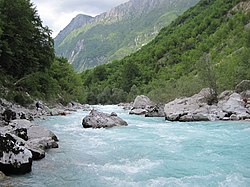
 The Soča nearBovec | |
| Location | |
| Country | Slovenia,Italy |
| Physical characteristics | |
| Source | |
| • location | Julian Alps,west ofTriglav |
| • elevation | 876 m (2,874 ft)[1] |
| Mouth | |
• location | Adriatic Sea,nearMonfalcone |
| Length | 138 km (86 mi)[1] |
| Basin size | 3,400 km2(1,300 sq mi)[2] |
| Discharge | |
| • average | 172 m3/s (6,100 cu ft/s)[2] |
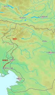
TheSoča(pronounced[ˈsoːtʃa]inSlovene) orIsonzo(pronounced[iˈzontso]inItalian;other namesFriulian:Lusinç,German:Sontig,Latin:AesontiusorIsontius[3]) is a 138-kilometre (86 mi) longriverthat flows through westernSlovenia(96 kilometres or 60 miles) and northeasternItaly(43 kilometres or 27 miles).[1]
AnAlpineriver in character, its source lies in theTrenta Valleyin theJulian Alpsin northwestern Slovenia, at an elevation of 876 metres (2,874 ft).[1]The river runs past the towns ofBovec,Kobarid,Tolmin,Kanal ob Soči,Nova Gorica(where it is crossed by theSolkan Bridge), andGorizia,entering theAdriatic Seaclose to the town ofMonfalcone.It has anival-pluvial regimein its upper course andpluvial-nivalin its lower course.[4]
Prior to theFirst World War,the river ran parallel to the border betweenKingdom of Italyand theAustro-Hungarian Empire.During World War I, it wasthe scene of bitter fightingbetween the two countries, culminating in theBattle of Caporettoin October and November 1917.
Name
[edit]The river was recorded in antiquity asAesontius,Sontius,andIsontius.Later attestations includesuper Sontium(in 507–11),a flumine Isontio(1028),in Lisonçum(1261),an die Ysnicz(1401), andan der Snicz(ca. 1440). The Slovene nameSočais derived from the form*Sǫťa,which was borrowed from Latin (and Romance)Sontius.In turn, this is probably based on thesubstratename*Aisontia,presumably derived from thePIEroot*Hei̯s-'swift, rushing', referring to a quickly moving river. Another possible origin is the pre-Romance root*ai̯s-'water, river'.[5]
Major changes in the watershed
[edit]
The present course of the river is the result of several dramatic changes that occurred during the past 2,000 years. According to theRomanhistorianStrabo,the river named Aesontius, which in Roman times flowed pastAquileiato the Adriatic Sea, was essentially theNatisoneandTorreriver system.[6]
In 585, a landslide cut off the upper part of the Natisone riverbed, causing itsavulsionand subsequentstream captureby the Bontius River. The original subterranean discharge of the Bontius into theTimavobecame obstructed, and another avulsion returned the new watercourse into the bed of the lower Natisone.
During the next centuries the estuary of this new river—the Soča—moved eastward until it captured the short coastal river Sdobba, through which the Isonzo now discharges into the Adriatic Sea. The former estuary (of the Aesontius, and the early Isonzo) in the newly formed lagoon ofGradobecame an independent coastal rivulet.[7]
Attractions
[edit]


Due to itsemerald-green water, the river is marketed as "The Emerald Beauty." It is said to be one of the rare rivers in the world that retain such a colour throughout their length.[8]Giuseppe Ungaretti,one of the greatest Italian poets, describes the Isonzo in the poem "The Rivers."
The river inspired the poetSimon Gregorčičto write his best-known poemSoči(To the Soča), one of the masterpieces of Slovene poetry. This region served as a location for the 2008DisneyfilmChronicles of Narnia: Prince Caspian.[9]
The river is also well known for the marble trout (Salmo marmoratus); this species is native to rivers of the northern Adriatic basin, and it lives in the upper course of the river. This species is endangered due to the introduction of other non-indigenous trout species sometime between World War I and World War II.[10]
The Soca Valley is a popular tourist destination due to its numerous natural attractions, including the Big Soča Gorge (Velika korita Soče), the Little Soča Gorge (Mala korita Soče), Kozjak Falls, Virje Falls, and theTolmin Gorges(Tolminska korita).
Significance in World War I
[edit]The valley was the stage of major military operations includingthe twelve battles of the Isonzoon theItalian frontin World War I between May 1915 and November 1917, in which over half a million Austro-Hungarian and Italian soldiers lost their lives.[11][12]
The Isonzo campaign comprised the following battles:
- First Battle of the Isonzo:23 June – 7 July 1915
- Second Battle of the Isonzo:18 July – 3 August 1915
- Third Battle of the Isonzo:18 October – 3 November 1915
- Fourth Battle of the Isonzo:10 November – 2 December 1915
- Fifth Battle of the Isonzo:9–17 March 1916
- Sixth Battle of the Isonzo:6–17 August 1916
- Seventh Battle of the Isonzo:14–17 September 1916
- Eighth Battle of the Isonzo:10–12 October 1916
- Ninth Battle of the Isonzo:1–4 November 1916
- Tenth Battle of the Isonzo:12 May – 8 June 1917
- Eleventh Battle of the Isonzo:19 August – 12 September 1917
- Twelfth Battle of the Isonzo:24 October – 7 November 1917, also known as theBattle of Caporetto
See also
[edit]References
[edit]- ^abcdRivers, longer than 25 km, and their catchment areas,Statistical Office of the Republic of Slovenia
- ^ab"Drainage Basin of the Mediterranean Sea"(PDF).Second Assessment of Transboundary Rivers, Lakes and Groundwaters.United Nations Economic Commission for Europe. August 2011. p. 159.ISBN978-92-1-117052-8.
- ^Richard J.A. Talbert, ed. (2000).Barrington Atlas of the Greek and Roman World: Map-By-Map Directory.Vol. I. Princeton, NJ and Oxford, UK: Princeton University Press. p. 273.ISBN0691049459.
- ^Brečko Grubar, Valentina; Kovačič, Gregor (2010)."Pokrajinskoekološka oznaka jadranskega povodja v Sloveniji s poudarkom na kakovosti vodnih virov"[Landscape Ecological Characterization of the Adriatic Sea Basin in Slovenia with an Emphasis on Water Resource Quality].Annales. Series historia et sociologia(in Slovenian).20(1): 153–168.
- ^Snoj, Marko (2009).Etimološki slovar slovenskih zemljepisnih imen.Ljubljana: Modrijan. pp. 386–387.
- ^Strabo, Geography, Vol. V, Chapter 1
- ^Brockhaus' Konversations-Lexikon. 14th ed., Leipzig, Berlin and Vienna 1894; Vol. 9, p. 727.
- ^"Soca River Whitewater Rafting".Archived fromthe originalon 2013-09-11.Retrieved2009-05-29.
- ^"Filming locations forThe Chronicles of Narnia: Prince Caspian".IMDb.com.
- ^"Marble trout (Salmo marmoratus)".Balkan Trout Restoration Group.Retrieved2009-05-29.
- ^FirstWorldWar.ComThe Battles of the Isonzo, 1915-17.
- ^See also John R. Schindler,Isonzo: The Forgotten Sacrifice of the Great War(2001).ISBN978-0275972042.
External links
[edit]- Condition of Soča atLog ČezsoškiArchived2016-03-03 at theWayback MachineandSolkanArchived2016-03-04 at theWayback Machine- graphs, in the following order, of water level, flow and temperature data for the past 30 days (taken inLog ČezsoškiandSolkanbyARSO)
- The Walks of Peace in the Soča Region Foundation.The Foundation preserves, restores and presents the historical and cultural heritage of the First World War in the area of the Isonzo Front for the study, tourist and educational purposes.(in Slovene, English, Italian, and German)
- Galleries of Soca river in kayakArchived2016-03-04 at theWayback Machine
- Awarded "EDEN - European Destinations of Excellence" non traditional tourist destination 2008

