
Sodus, New York
Sodus, New York | |
|---|---|
 A church inSodus Point | |
 Location inWayne Countyand the state ofNew York. | |
 Sodus, New York Location within the state of New York | |
| Coordinates:43°14′10″N77°04′05″W/ 43.23611°N 77.06806°W | |
| Country | United States |
| State | New York |
| County | Wayne |
| Established | January 1789[1] |
| Government | |
| • Type | Town Board |
| •Supervisor | Scott Johnson[2] |
| •Clerk | Lorraine Diver |
| •Court | Justice Robert A. Fratengelo Justice Thomas A. Putnam |
| Area | |
| • Total | 69.25 sq mi (179.35 km2) |
| • Land | 67.27 sq mi (174.22 km2) |
| • Water | 1.98 sq mi (5.13 km2) |
| Elevation | 451 ft (137 m) |
| Population (2010) | |
| • Total | 8,384 |
| • Estimate (2016)[4] | 8,105 |
| • Density | 120.49/sq mi (46.52/km2) |
| Time zone | UTC-5(Eastern (EST)) |
| • Summer (DST) | UTC-4(EDT) |
| ZIP code | 14551 |
| Area code(s) | 315and680 |
| FIPS code | 36-68209 |
| GNISfeature ID | 0965619 |
| Website | https://www.townofsodus.net/ |
Sodusis atowninWayne County,New York,United States. The population was 8,384 at the 2010 census. The town takes its name from a native word for the bay in the eastern part of the town: "Assorodus," meaning "silvery water."
TheTown of Sodusis on the north border of the county and is midway betweenRochesterandSyracuse.
History
[edit]
The Town of Sodus was formed in 1789 from the older "District of Sodus" while still part ofOntario County.The town's Adam territory was substantially reduced by the formation of newer towns in the county:Williamson(1802) andLyons(1811).
The town contains a village also namedSodusand another namedSodus Point.Sodus Point was settled around 1794 because of a road constructed fromPalmyra,but the first settlers did not arrive at the Village of Sodus until about 1809.
In 1813, theBritishattacked and burned the village of Sodus Point.
Alighthousewas erected in 1825 to mark the shoreline.
Members of theShakerssettled in the early town, but moved away, when they believed Sodus was becoming too worldly. Sodus claims to be the birthplace ofArbor Day,a holiday established by the efforts of Sodus Center native Edward C. Delano.
AHeluva Good!Country Store was located near the hamlet ofWallington.[5]The cheese packaging plant in Sodus and the Heluva Good! Country Store both closed on June 26, 2015.[6]The company is asubsidiaryofHP Hood LLC,headquartered inLynnfield, Massachusetts.
ThePreston-Gaylord Cobblestone Farmhousewas listed on theNational Register of Historic Placesin 2009.[7]
Geography
[edit]According to theUnited States Census Bureau,the town has a total area of 69.4 square miles (179.6 km2), of which 67.4 square miles (174.6 km2) is land and 1.9 square miles (5.0 km2) (2.78%) is water.
The northern border of Sodus isLake Ontario.Sodus Bay,abayof Lake Ontario is partly in the town.
Sodus is a town on the northern boundary of the United States, and Canada is on the opposite shore of Lake Ontario.
New York State Route 14intersectsNew York State Route 104south of Alton, andNew York State Route 88runs south from Sodus village.
Sodus is also known for its rural landscape and its many apple orchards.
Demographics
[edit]| Census | Pop. | Note | %± |
|---|---|---|---|
| 1820 | 2,013 | — | |
| 1830 | 3,528 | 75.3% | |
| 1840 | 4,472 | 26.8% | |
| 1850 | 4,598 | 2.8% | |
| 1860 | 4,745 | 3.2% | |
| 1870 | 4,631 | −2.4% | |
| 1880 | 5,285 | 14.1% | |
| 1890 | 5,157 | −2.4% | |
| 1900 | 5,118 | −0.8% | |
| 1910 | 4,857 | −5.1% | |
| 1920 | 4,408 | −9.2% | |
| 1930 | 5,003 | 13.5% | |
| 1940 | 5,162 | 3.2% | |
| 1950 | 5,706 | 10.5% | |
| 1960 | 6,587 | 15.4% | |
| 1970 | 8,754 | 32.9% | |
| 1980 | 9,485 | 8.4% | |
| 1990 | 8,877 | −6.4% | |
| 2000 | 8,949 | 0.8% | |
| 2010 | 8,384 | −6.3% | |
| 2016 (est.) | 8,105 | [4] | −3.3% |
| U.S. Decennial Census[8] | |||
As of thecensus[9]of 2010, there were 8,384 people, 3,325 households, and 2,189 families residing in the town. The population density was 120.8 inhabitants per square mile (46.6/km2). The racial makeup of the town was 84.8%White,8.5%BlackorAfrican American,0.3%Native American,0.4%Asian,0.1%Pacific Islander,3.1% fromother races,and 2.9% from two or more races.HispanicorLatinoof any race were 6.2% of the population.
There were 3,325 households, out of which 24.9% had children under the age of 18 living with them, 49.0% weremarried couplesliving together, 11.6% had a female householder with no husband present, and 34.2% were non-families. 27.2% of all households were made up of individuals, and 10.6% had someone living alone who was 65 years of age or older. The average household size was 2.48 and the average family size was 2.97.
In the town, the population was spread out, with 24.6% under the age of 20, 5.1% from 20 to 24, 21.7% from 25 to 44, 32.1% from 45 to 64, and 16.5% who were 65 years of age or older. The median age was 43.8 years. For every 100 females, there were 98.3 males. For every 100 females age 18 and over, there were 97.7 males.
The median income for a household in the town was $46,896, and the median income for a family was $56,128. Males had a median income of $42,735 versus $37,267 for females. Theper capita incomefor the town was $23,898. About 11.4% of families and 14.9% of the population were below thepoverty line,including 23.6% of those under age 18 and 7.7% of those age 65 or over.
Housing
[edit]There were 4,158 housing units at an average density of 59.9 per square mile (23.1/km2); a total of 20.0% of housing units were vacant.
There were 3,325 occupied housing units in the town, of which 2,585 were owner-occupied units (77.7%), while 740 were renter-occupied (22.3%). The homeowner vacancy rate was 2.5% of total units. The rental unit vacancy rate was 14.8%.[9]
NOTE: It is common for resort communities to have higher than normal vacant house counts. Many are vacation homes which are seasonal and not regularly occupied.
Notable people
[edit]- John Ashbery(1927 – 2017), Poet
- Gordon Granger(1821 – 1876), Union Army General
- Byram Green(1786 – 1865), US Congressman
- Ellen Sergeant Rude(1838-1916), writer, poet, and temperance advocate
- Eliphalet Stone(1825-1905), Wisconsin state legislator
- Alexander B. Williams(b. 1815), Sodus Town Supervisor and state legislator
Communities and locations in the Town of Sodus
[edit]- Alton— A hamlet near the east town line on NY-14.Alasa Farmswas listed on theNational Register of Historic Placesin 2009.[7]
- Beechwood State Park— A former Girl Scout camp along the Lake Ontario shore, now owned by New York State and operated by the Town of Sodus.
- Bootleggers Point— A location on the Lake Ontario shore in the west part of the town.
- Joy— A hamlet south of Sodus village at the junction of County Road 229 and Main Street.
- Sodus— The Village of Sodus is near the town center at the north end of NY-88.
- Sodus Center— A hamlet southeast of Sodus village at the junction of County Roads 240 and 241. TheRed Brick Churchwas listed on the National Register of Historic Places in 1997.[7]
- Sodus Point— The Village of Sodus Point is on County Road 101 (Lake Road) on the shore of Lake Ontario.
- South Sodus— A hamlet in the southeast corner of the town on NY-14.
- Thorntons Corner— A hamlet in the south part of the town at the junction of County Roads 242 and 243.
- Thornton Point— Apeninsulain Sodus Bay.
- Wallington— A hamlet southeast of Sodus village on NY-104. TheWalling Cobblestone TavernandWallington Cobblestone Schoolhouse District No. 8were listed on the National Register of Historic Places in 1994.[7]
- Williamson-Sodus Airport(ICAO:KSDC,FAALID:SDC) — A general aviationairportin the western part of the town, south of NY-104.
References
[edit]- ^Wayne County Office of County Historian - Town of Sodus History,Retrieved June 7, 2015.
- ^Town of Sodus - Sodus Town Supervisor,Retrieved January 30, 2020.
- ^"2016 U.S. Gazetteer Files".United States Census Bureau.RetrievedJuly 5,2017.
- ^ab"Population and Housing Unit Estimates".RetrievedJune 9,2017.
- ^Heluva Good! Country Store Information,Retrieved January 19, 2015.
- ^Democrat & Chronicle (Rochester, NY) -Heluva Good! plant, store in Wayne Co. to closeby David Andreatta (April 19, 2015),Retrieved April 19, 2015.
- ^abcd"National Register Information System".National Register of Historic Places.National Park Service.July 9, 2010.
- ^"Census of Population and Housing".Census.gov.RetrievedJune 4,2015.
- ^ab"U.S. Census website".United States Census Bureau.RetrievedJanuary 18,2015.
External links
[edit]- Historical summary of the Town of Sodus, NY
- Sodus Chamber of Commerce website
- Sodus, New York website
- Historical links for Sodus
- RW&O Railroad, Sodus, NY
- RW&O Railroad, Alton, NY
- Heluva Good!
Municipalities and communities ofWayne County, New York,United States | ||
|---|---|---|
| Towns | 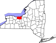 | |
| Villages | ||
| CDPs | ||
| Hamlets | ||
| Footnotes | ‡This populated place also has portions in an adjacent county or counties | |
| International | |
|---|---|
| National | |