Province of Brabant
| Province of Brabant | |||||||||||||
|---|---|---|---|---|---|---|---|---|---|---|---|---|---|
| FormerprovinceofBelgium (Netherlandsuntil 1830) | |||||||||||||
| 1815–1995 | |||||||||||||
|
Flag | |||||||||||||
 | |||||||||||||
| Capital | Brussels | ||||||||||||
| Demonym | Brabantian | ||||||||||||
| History | |||||||||||||
• Established | 1815 | ||||||||||||
• Disestablished | 1995 | ||||||||||||
| |||||||||||||

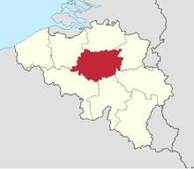
TheProvince of Brabant(/brəˈbænt/,USalso/brəˈbɑːnt,ˈbrɑːbənt/,[1][2][3]Dutch:[ˈbraːbɑnt]) was aprovinceinBelgiumfrom 1830 to 1995. It was created in 1815 asSouth Brabant,part of theUnited Kingdom of the Netherlands.[4]In 1995, it was split into theDutch-speakingFlemish Brabant,the French-speakingWalloon Brabantand the bilingualBrussels-Capital Region.[5]
History
[edit]United Kingdom of the Netherlands
[edit]After the defeat ofNapoleonin 1815, theUnited Kingdom of the Netherlandswas created at theCongress of Vienna,consisting of territories which had been added toFranceby Napoleon: the formerDutch Republicand theSouthern Netherlands.In the newly created kingdom, the formerFrench départementofDylebecame the new province ofSouth Brabant,distinguishing it fromCentral Brabant(laterAntwerp province); and fromNorth Brabant(now part of theNetherlands), all named after the formerDuchy of Brabant.
The provincial governors during this time were:
- 1815–1818:François Joseph Charles Marie de Mercy-Argenteau
- 1818–1823:Philippe d'Arschot Schoonhoven
- 1823–1828:Leonard du Bus de Gisignies
- 1828–1830:Hyacinthe van der Fosse
Belgium
[edit]
After theBelgian Revolutionof 1830, the Southern Netherlands (including South and Central Brabant) became independent as Belgium and later alsoLuxembourg.The province was then renamed simplyBrabantand became the central province of Belgium, with its capital cityBrussels.The province contained three arrondissements:Brussels,LeuvenandNivelles.
In 1961–1963, the language border was established, from which the province was divided into a Dutch-speaking region, a French-speaking region and the bilingual Brussels. The Brussels arrondissement was split to this end. In 1989,Brussels-Capital Regionwas created, but the region was still part of the province of Brabant. In 1995, the province of Brabant was split into the Dutch-speakingFlemish Brabant,the French-speakingWalloon Brabantand the bilingual Brussels-Capital Region. The Brussels-Capital Regionexercises the powers of a Province on its own territory.
Demographics
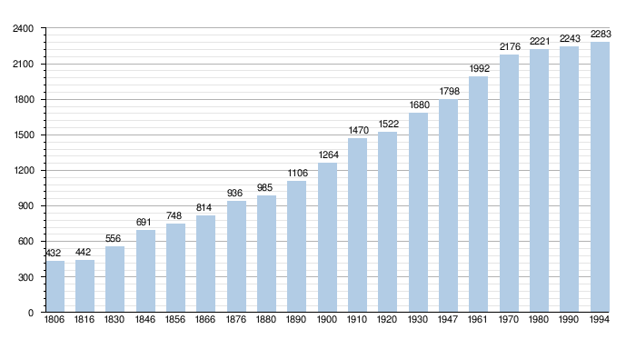
[edit]As comparison, the current two provinces of Brabant, together with Brussels, had 2,621,275 inhabitants in January 2011.
Number of inhabitants x 1000

- Source: NIS
- 1806 till 1970: census
- 1980 and 1990: number of inhabitants on 1 January
- 1994: number on 31 December
See also
[edit]References
[edit]- ^"Brabant".Collins English Dictionary.HarperCollins.RetrievedMay 29,2019.
- ^"Brabant"(US) and"Brabant".LexicoUK English Dictionary.Oxford University Press.Archived fromthe originalon 2020-09-29.
- ^"Brabant".Merriam-Webster.com Dictionary.Merriam-Webster.RetrievedMay 29,2019.
- ^Chisholm, Hugh,ed. (1911)..Encyclopædia Britannica(11th ed.). Cambridge University Press.
- ^"Administratief Arrondissement Brussel-Hoofdstad".Archived fromthe originalon 2016-08-29.Retrieved2011-09-17.

