
Southern Yatsugatake Volcanic Group
| Southern Yatsugatake Volcanic Group | |
|---|---|
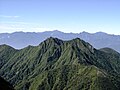
 Yatsugatake fromMount Gongen(August 2010) | |
| Highest point | |
| Peak | Mount Aka |
| Elevation | 2,899 m (9,511 ft) |
| Coordinates | 35°58′15″N138°22′12″E/ 35.97083°N 138.37000°E |
| Naming | |
| Etymology | Southern mountains with eight peaks |
| Native name | |
| Geography | |
 Southern Yatsugatake Volcanic Group | |
| Country | Japan |
| Prefectures | Nagano Prefecture and Yamanashi Prefecture |
| Region | Chūbu |
| Districts | MinamisakuandSuwa |
| Municipalities | Hara,Fujimi,Chino,HokutoandMinamimaki |
| Parent range | Yatsugatake Mountains |
| Borders on | Northern Yatsugatake Volcanic Group |
| Biome | Alpine climate |
| Geology | |
| Orogeny | Island arc |
| Age of rock | Quaternary |
| Type of rock | Volcanic |

Southern Yatsugatake Volcanic Group(Nam bát ヶ nhạc,Minami-Yatsugatake),also known as justYatsugatakeis avolcanic groupof inactivevolcanoeslocated on the border ofNagano PrefectureandYamanashi PrefectureonHonshūinJapan.
Description[edit]
The Southern Yatsugatake Volcanic Group is part of theYatsugatake Mountains.The southern group is defined as the mountains south of theNatsuzawa Pass.The highest peak of the mountains isMount Akaand the elevation is 2,899 metres.
The southern Yatugatake mountains are steep and have alpine characteristics. The mountains of theNorthern Yatsugatake Volcanic Groupare gentler and lower.Mount Tateshinais also part of the Northern Yatsugatake mountains, but is listed separately.
This volcanic group is listed amongthe 100 famous mountains in Japan.There the mountains are listed asYatsugatake.
These mountains are part of theYatsugatake-Chūshin Kōgen Quasi-National Park.[1]
Geology[edit]
The volcanoes arestratovolcanoesthat are 1 million to 200,000 years old. The rock is mainlybasaltandandesite.[2]
Climate[edit]
| Climate data forNobeyama Station,1991–2020 normals, extremes 1978–present | |||||||||||||
|---|---|---|---|---|---|---|---|---|---|---|---|---|---|
| Month | Jan | Feb | Mar | Apr | May | Jun | Jul | Aug | Sep | Oct | Nov | Dec | Year |
| Record high °C (°F) | 11.9 (53.4) |
15.6 (60.1) |
20.1 (68.2) |
24.9 (76.8) |
26.5 (79.7) |
28.6 (83.5) |
30.7 (87.3) |
31.0 (87.8) |
29.1 (84.4) |
24.9 (76.8) |
19.7 (67.5) |
16.9 (62.4) |
31.0 (87.8) |
| Mean daily maximum °C (°F) | 0.1 (32.2) |
1.1 (34.0) |
5.4 (41.7) |
12.1 (53.8) |
17.2 (63.0) |
19.9 (67.8) |
23.7 (74.7) |
24.7 (76.5) |
20.3 (68.5) |
14.7 (58.5) |
9.6 (49.3) |
3.5 (38.3) |
12.7 (54.9) |
| Daily mean °C (°F) | −5.3 (22.5) |
−4.5 (23.9) |
−0.3 (31.5) |
5.8 (42.4) |
11.0 (51.8) |
14.8 (58.6) |
18.9 (66.0) |
19.5 (67.1) |
15.5 (59.9) |
9.3 (48.7) |
3.8 (38.8) |
−1.9 (28.6) |
7.2 (45.0) |
| Mean daily minimum °C (°F) | −12.2 (10.0) |
−11.4 (11.5) |
−6.4 (20.5) |
−0.6 (30.9) |
4.9 (40.8) |
10.2 (50.4) |
15.0 (59.0) |
15.5 (59.9) |
11.4 (52.5) |
4.4 (39.9) |
−1.8 (28.8) |
−7.9 (17.8) |
1.8 (35.2) |
| Record low °C (°F) | −25.1 (−13.2) |
−26.0 (−14.8) |
−25.3 (−13.5) |
−18.7 (−1.7) |
−6.6 (20.1) |
−1.4 (29.5) |
4.8 (40.6) |
4.2 (39.6) |
−2.2 (28.0) |
−8.9 (16.0) |
−14.1 (6.6) |
−23.1 (−9.6) |
−26.0 (−14.8) |
| Averageprecipitationmm (inches) | 46.6 (1.83) |
49.8 (1.96) |
93.4 (3.68) |
100.6 (3.96) |
124.9 (4.92) |
172.6 (6.80) |
205.6 (8.09) |
166.8 (6.57) |
204.1 (8.04) |
164.6 (6.48) |
62.4 (2.46) |
41.0 (1.61) |
1,432.4 (56.39) |
| Average precipitation days(≥ 1.0 mm) | 6.1 | 6.1 | 9.7 | 9.8 | 10.9 | 13.7 | 15.1 | 13.0 | 11.9 | 10.0 | 7.0 | 5.8 | 119.4 |
| Mean monthlysunshine hours | 175.7 | 167.1 | 179.8 | 188.3 | 186.0 | 127.7 | 142.2 | 160.1 | 124.1 | 140.2 | 167.9 | 175.5 | 1,933.7 |
| Source 1:JMA[3] | |||||||||||||
| Source 2:JMA[4] | |||||||||||||
List of peaks[edit]
The following major peaks make up part of the Southern Yatsugatake Volcanic Group and are listed by height:[2][5]
| Name | Height |
|---|---|
| Mount Aka(Xích nhạc,Aka-dake) | 2,899.2 metres (9,511.8 ft) |
| Mount Yoko(Hoành nhạc,Yoko-dake) | 2,829 metres (9,281 ft) |
| Mount Amida(A di đà nhạc,Amida-dake) | 2,805 metres (9,203 ft) |
| Mount Iō(Lưu hoàng nhạc,Iō-dake) | 2,760 metres (9,060 ft) |
| Mount Gongen(権 hiện nhạc,Gongen-dake) | 2,715 metres (8,907 ft) |
| Mount Amigasa(Biên lạp sơn,Amigasa-yama) | 2,523.7 metres (8,279.9 ft) |
| Mount Nishi(Tây nhạc,Nishi-dake) | 2,398 metres (7,867 ft) |
From the south, to Natuzawa Pass, beyond which the Northern Yatsugatake Mountains begin, the peaks are:
- Mt. Amigasayama (2,524 m)
- Mt. Nishidake (2,398 m)
- Mt. Mitsugashira (2,580 m)
- Mt. Gongendake (2,715 m)
- Mt. Aka (2,899 m)
- Mt. Nakadake (2,700 m)
- Mt. Amidadake (2,805 m)
- Mt. Yoko (2,829 m)
- Mt. Iōdake (2,760 m)
- Mt. Akaiwanoatama (2,656 m)
- Mt. Minenomatsume (2,567 m)
- Natsuzawa Pass (2,423 m)
From Natsuzawa Pass, it is possible to descend to Sakuradaira, via O-ren Hut and Natsuzawa Kosen, or directly to Honzawa Onsen, or continue through the Northern Yatsugatake Mountains.
Gallery[edit]
-
 Mount Aka, the highest peak of the Yatsugatake mountains
 -
 Mount Gongen, from Mount Aka
 -
 Mount Amida, Mount Iō, Mount Yoko and Mount Aka from Mount Gongen
 -
 Mount Amida, Mount Iō, Mount Yoko, Mount Aka and Mount Gongen from Mount Amigasa
 -
 Mt Iō taken from Natsuzawa Pass in March 2024.jpg


See also[edit]
References[edit]
- ^Bát ヶ nhạc trung tín cao nguyên quốc định công viên.Japan Integrated Biodiversity Information System(in Japanese). Ministry of the Environment, Government of Japan. Archived fromthe originalon 2008-05-12.Retrieved2008-09-05.
- ^ab"YATSU-GA-TAKE".Quaternary Volcanoes of Japan.Geological Survey of Japan, AIST. 2006.Retrieved2008-08-19.
- ^Quan trắc sử thượng 1~10 vị の trị ( niên gian を thông じての trị ).JMA.RetrievedFebruary 16,2022.
- ^Khí tượng sảnh / bình niên trị ( niên ・ nguyệt ごとの trị ).JMA.RetrievedFebruary 16,2022.
- ^Hunt, Paul (1988). "14. Yatsu-ga-take".Hiking in Japan: An Adventurer's Guide to the Mountain Trails(First ed.). Tokyo: Kondansha International. pp. 111–115.ISBN0-87011-893-5.
External links[edit]
See also[edit]
- Yatsugatake-Chūshin Kōgen Quasi-National Park
- Yatsugatake Mountains-Northern Yatsugatake Volcanic Group
- List of mountains in Japan
| Hokkaidō | |||||||||
|---|---|---|---|---|---|---|---|---|---|
| Tōhoku region Jōshinetsu region |
| ||||||||
| Kantō region | |||||||||
| Chūbu region |
| ||||||||
| Western Japan | |||||||||
| |||||||||
| International | |
|---|---|
| National | |