
State highways in California
   Standard route signage in California | |
 | |
| System information | |
|---|---|
| Notes | All classes of state-numbered highways are generally state-maintained. |
| Highway names | |
| Interstates | Interstate X (I-X) |
| US Highways | U.S. Route X (US X) |
| State | State Route X (SR X) |
| System links | |
Thestate highway systemof theU.S. stateofCaliforniais a network ofhighwaysthat are owned and maintained by theCalifornia Department of Transportation(Caltrans).
Each highway is assigned aRoute(officiallyState Highway Route[1][2]) number in theStreets and Highways Code (Sections 300–635).Most of these are numbered in a statewide system, and are known asState Route X(abbreviatedSR X).United States Numbered Highwaysare labeledUS X,andInterstate HighwaysareInterstate X.Under the code, the state assigns a uniqueRoute Xto each highway, and does not differentiate between state, US, or Interstate highways.
TheCalifornia Highway Patrol(CHP) is tasked withpatrollingall state highways to enforce traffic laws.[3]
Overview
[edit]
California's highway system is governed pursuant toDivision 1 of the California Streets and Highways Code,which is one of the 29California Codesenacted by the state legislature. Since July 1 of 1964, the majority oflegislative route numbers,those defined in the Streets and Highways Code, match thesign route numbers.For example,Interstate 5is listed as "Route 5" in the code.
On the other hand, some short routes are instead signed as parts of other routes — for instance,Route 112andRoute 260are signed as part of the longerState Route 61,andRoute 51is part ofInterstate 80 Business.
Concurrencesare not explicitly codified in the Streets and Highways Code; such highway segments are listed on only one of the corresponding legislative route numbers — for example, theI-80/I-580concurrency, known as theEastshore Freeway,only falls under the Route 80 description in the highway code while the definition of Route 580 is broken into non-contiguous segments.
The state mayrelinquishsegments of highways and turn them over to local control. If the relinquished segment is in the middle of the highway's route, the local jurisdiction is usually required to install and maintain signs directing drivers to the continuation of that highway; they are not generally required to do so if the relinquishment effectively truncates the highway at one end, or is done as part of the process to re-route a highway. The state may alsodeletea highway completely and turn over an entire state route to local control.
Business routesare not maintained by the state unless they are also assigned legislative route numbers. A route or sections of a route may also be consideredunrelinquished- a new alignment has been built, or the legislative definition has changed to omit the section, but the state still owns the roadway — and are officiallyRoute XU.For example,State Route 14Uis an old alignment ofState Route 14whose control has not yet been transferred to theCity of Santa Clarita.
Some new alignments are consideredsupplemental[4]and have a suffix of S. For example, an expressway replacement forState Route 86between approximately three miles north of theImperial/RiversideCounty line andInterstate 10east ofIndiowas initially signed asState Route 86Suntil it was eventually transferred to SR 86. Likewise, the freeway replacement forState Route 180inFresnowas initially referred to asState Route 180S.
History
[edit]
The first legislative routes were defined by the State Highway Bond Act in 1909, passed by theCalifornia State Legislatureand signed by GovernorJames Gillett.These, and later extensions to the system, were numbered sequentially. No signs were erected for these routes.
TheUnited States Numbered Highwayswere assigned by theAmerican Association of State Highway Officials(AASHO) in November 1926, but posting did not begin in California until January 1928. These were assigned to some of the main legislative routes in California. Initially, signs were posted by theAutomobile Club of Southern California(ACSC) andCalifornia State Automobile Association(CSAA), which had been active in signingnational auto trailsand local roads since the mid-1900s.
In 1934, after the major expansion of the state highway system in 1933 by the California Legislature, California sign route numbers were assigned by the California Division of Highways (predecessor to Caltrans). The California sign route numbers were assigned in a geographical system, completely independent of the legislative routes. Odd-numbered routes ran north–south and even-numbered routes ran east–west. The routes were split among southern California (ACSC) and central and northern California (CSAA) as follows:
- 0 or 1modulo4: central and northern California
- 2 or 3 modulo 4: southern California
For instance,State Route 1andState Route 4were in central and northern California, andState Route 2andState Route 3(since moved) were in southern California. A rough grid was used inside the two regions, with the largest numbers — all less than 200 (except forState Route 740,which was related toState Route 74) - in eastern California (north–south) and near the border between the two regions (east–west).
TheInterstate Highway Systemnumbers were assigned by AASHO in late 1959. In 1963 and 1964, a total renumbering of the legislative routes was made, aligning them with the sign routes. Some changes were also made to the sign routes, mostly related to decommissionings of U.S. Routes in favor of Interstates.
Since the 1990s, many non-freewayroutes, especially inurban areas,have been deleted and turned over to local control. This transfers the cost of maintaining them from state to local budgets, but also gives local governments direct control over urban arterial roads that carry primarily local traffic. Once transferred, if a local government wants to add landscaping in the center median or install additional traffic lights or other traffic control devices, it can immediately do so itself rather than having to negotiate with Caltrans. Not all cities have been prepared to accept such routes from Caltrans simultaneously, so many have been decommissioned from the state system one fragment at a time. In the case of the San Francisco Bay Area, the Caltrans district responsible for that region is granted permission to retain in the State highway system routes that run on conventional (non freeway or expressway) roadways unless a freeway is built to bypass the surface street route.
Nomenclature in California English
[edit]Onecultural difference between Northern and Southern Californiansis that the latter tend to put thedefinite article"the" before highway numbers (e.g. "takingthe5toL.A."), while the former use the number alone (e.g." taking80toSan Francisco") or less frequently, with" I- "in the case of interstate freeways.[5][6][7]The Southern California usage of the definite article is seen as stereotypical of Southern California "surfer" culture, and has been parodied in the recurringSaturday Night Livesketch "The Californians".[8]When theSouthern California freeway systemwas built in the 1940s and early 1950s, local common usage was primarily the freeway name preceded by the definite article, such as "the Hollywood Freeway".[9]It took several decades for Southern California locals to start to commonly refer to the freeways with the numerical designations, but usage of the definite article persisted. For example, it evolved to "the 605 Freeway" and then shortened to "the 605".[9]This did not occur in Northern California, where usage of the route numbers was more common.
- Signage along northboundU.S. Route 101reflecting the different lexicon usage
-
 Signage at the110 Freewayinterchange inLos Angeles,with the leftmost sign for the 101 north listing both its name, theHollywood Freeway,as well as its destination,Ventura
 -
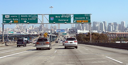 Signage at theInterstate 80interchange inSan Francisco,with the leftmost sign for US 101 north only listing its destination, theGolden Gate Bridge


List of routes
[edit]The list of routes, as defined in the California Streets and Highways code, is split into the following pages:
- List of Interstate Highways in California
- List of U.S. Routes in California
- List of state highways in California
Former U.S. Routes In California
[edit]

- U.S. Route 40
- U.S. Route 40 Alternate
- U.S. Route 48
- U.S. Route 60
- U.S. Route 66
- U.S. Route 70
- U.S. Route 80
- U.S. Route 91
- U.S. Route 99
- U.S. Route 99E (central California)
- U.S. Route 99E (northern California)
- U.S. Route 99W (central California)
- U.S. Route 99W (northern California)
- U.S. Route 101A
- U.S. Route 101 Bypass(San Francisco Bay area)
- U.S. Route 101 Bypass(Los Angeles & Orange counties)
- U.S. Route 101E
- U.S. Route 101W
- U.S. Route 299
- U.S. Route 399
- U.S. Route 466
See also
[edit] California Roads portal
- Deleted California State Highways
- Unconstructed California State Highways
- Scenic California State Highways
- List of county routes in California
References
[edit]- ^California Streets and Highways Code, Section 231
- ^Caltrans,Other State Highway Routes
- ^Cal. Sts. & High. Code §§ 2400, 2401.
- ^Metadata for ST_HWY GIS data layer(PDF)
- ^Simon, Mark (2000-06-30)."'The' Madness Must Stop Right Now ".San Francisco Chronicle.Retrieved2009-09-22.
- ^Simon, Mark (2000-07-04)."Local Lingo Keeps 'The' Off Road".San Francisco Chronicle.Retrieved2009-09-22.
- ^Simon, Mark (2000-07-29)."S.F. Wants Power, Not The Noise / Brown rejects docking floating plant off city".San Francisco Chronicle.Retrieved2009-09-22.
- ^Rose, Joseph (April 16, 2012)."Saturday Night Live's 'The Californians': Traffic's one big soap opera (video)".The Oregonian.Portland, Oregon.RetrievedDecember 3,2013.
- ^abGeyer, Grant (Summer 2001). "'The' Freeway in Southern California ".American Speech.76(2): 221–224.doi:10.1215/00031283-76-2-221.S2CID144010897.
External links
[edit]- California Highways- Provides a complete history of California State Routes and every state route.
- Road Signs of California
- AARoads California Highways Page
- 1964 Highway Renumbering
- Historic California U.S. Routes
- California by RV- Provides complete maps of California Main State Routes.