
Subcarpathian Voivodeship


Subcarpathian Voivodeshipis avoivodeship,orprovince,in the southeastern corner ofPoland.Its administrative capital and largest city isRzeszów.Along with the Marshal, it is governed by theSubcarpathian Regional Assembly.
The name derives from the region's location near theCarpathian Mountains,and the voivodeship comprises areas of two historic regions of Central Europe—Lesser Poland(western and northwestern counties) andCherven Cities/Red Ruthenia.
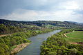
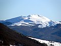
It is bordered byLesser Poland Voivodeshipto the west,Świętokrzyskie Voivodeshipto the north-west,Lublin Voivodeshipto the north,Ukraine(Lviv OblastandZakarpattia Oblast) to the east andSlovakia(Prešov Region) to the south. It covers an area of 17,844 square kilometres (6,890 sq mi), and has a population of 2,127,462 (as at 2019). The voivodeship is mostly hilly or mountainous (seeBieszczady,Beskidy); its northwestern corner is flat. It is one of the most wooded Polish voivodeships (35.9% of total area), within its borders there is wholeBieszczady National Park,and parts ofMagura National Park.
History[edit]


In theEarly Middle Ages,the territory was inhabited by theVistulansandLendians,oldPolish tribes.It formed part of Poland since its first historic rulerMieszko I,however, later on, at various times, portions of the region fell under theKievan Rus',theGolden Horde,and theKingdom of Hungary,before Poland regained full control in the 14th century. Following thePartitions of Polandthe entire region was annexed byAustriaand included within the newly establishedKingdom of Galicia and Lodomeria.The oldest cities in the province, with over 1,000 years of history, arePrzemyślandSanok.Rzeszów,ŁańcutandTarnobrzeg,with their castles and palaces, were important residential cities of the powerful Polish magnate families ofLubomirski,PotockiandTarnowski.
During theinterwar period(1918–1939), territory of the Subcarpathian Voivodeship was part of theLwów Voivodeshipand belonged to"Poland B",the less-developed, more rural parts of Poland. To boost the local economy, the government of theSecond Polish Republicbegan in the mid-1930s a massive program of industrialization, known as theCentral Industrial Region.The program created several major armament factories, includingPZL Mielec,PZL Rzeszów,Huta Stalowa Wola,and factories in other Subcarpathian towns such asDębica,Nowa Dęba,Sanok,TarnobrzegandNowa Sarzyna.
Following the joint German-Sovietinvasion of Poland,which startedWorld War IIin September 1939, most of the current province wasoccupied by Nazi Germanywith the eastern outskirts occupied by the Soviet Union, and the city of Przemyśl divided between the occupiers until 1941, and then the entire region occupied by Germany until 1944.
Following the Soviet annexation of the regional capital ofLwów,Rzeszówwas chosen as the new regional capital and theRzeszów Voivodeshipwas founded.
Thevoivodeshipwas created on 1 January 1999 out of the formerRzeszów,Przemyśl,Krosnoand (partially)TarnówandTarnobrzegVoivodeships, pursuant to thePolish local-government reformsadopted in 1998.
Government[edit]
Subcarpathian Voivodeship's government powers are shared between thevoivode(governor), thesejmik(regional assembly), and themarshal.
Cities and towns[edit]


The voivodeship contains 6 cities and 45 towns. These are listed below in descending order of population (according to official figures as of 2019)[4]
- Rzeszów(194,886)
- Przemyśl(60,999)
- Stalowa Wola(60,799)
- Mielec(60,366)
- Tarnobrzeg(46,907)
- Krosno(46,369)
Towns:
- Dębica(45,634)
- Jarosław(37,585)
- Sanok(37,381)
- Jasło(35,063)
- Łańcut(17,709)
- Ropczyce(15,836)
- Przeworsk(15,356)
- Nisko(15,324)
- Leżajsk(13,853)
- Sędziszów Małopolski(12,357)
- Lubaczów(12,018)
- Nowa Dęba(11,152)
- Ustrzyki Dolne(9,097)
- Kolbuszowa(9,075)
- Strzyżów(8,884)
- Brzozów(7,463)
- Rudnik nad Sanem(6,710)
- Głogów Małopolski(6,654)
- Boguchwała(6,179)
- Dynów(6,129)
- Nowa Sarzyna(5,834)
- Jedlicze(5,736)
- Lesko(5,424)
- Radymno(5,279)
- Zagórz(5,095)
- Pilzno(4,912)
- Sokołów Małopolski(4,193)
- Rymanów(3,825)
- Tyczyn(3,824)
- Pruchnik(3,764)
- Radomyśl Wielki(3,231)
- Kańczuga(3,167)
- Zaklików(2,979)
- Oleszyce(2,974)
- Brzostek(2,752)
- Sieniawa(2,140)
- Błażowa(2,139)
- Narol(2,109)
- Dukla(2,061)
- Cieszanów(1,913)
- Iwonicz-Zdrój(1,787)
- Przecław(1,775)
- Baranów Sandomierski(1,456)
- Ulanów(1,422)
- Kołaczyce(1,409)
- Jawornik Polski
- Bircza
- Dubiecko(866)
Administrative division[edit]
Subcarpathian Voivodeship is divided into 25 counties (powiats): 4 city counties and 21 land counties. These are further divided into 160gminas.
The counties are listed in the following table (ordering within categories is by decreasing population).
| English and Polish names |
Area | Population (2019) |
Seat | Other towns | Total gminas | |
| km2 | sq mi | |||||
| City counties | ||||||
| Rzeszów | 77 | 30 | 194,886 | 1 | ||
| Przemyśl | 44 | 17 | 60,999 | 1 | ||
| Tarnobrzeg | 86 | 33 | 46,907 | 1 | ||
| Krosno | 43 | 17 | 46,369 | 1 | ||
| Land counties | ||||||
| Rzeszów County powiat rzeszowski |
471 | 182 | 168,614 | Rzeszów* | Boguchwała,Głogów Małopolski,Sokołów Małopolski,Błażowa,Tyczyn | 14 |
| Mielec County powiat mielecki |
880 | 340 | 136,591 | Mielec | Radomyśl Wielki,Przecław | 10 |
| Dębica County powiat dębicki |
776 | 300 | 135,348 | Dębica | Pilzno,Brzostek | 7 |
| Jarosław County powiat jarosławski |
1,029 | 397 | 120,462 | Jarosław | Radymno,Pruchnik | 11 |
| Jasło County powiat jasielski |
830 | 320 | 113,730 | Jasło | Kołaczyce | 10 |
| Krosno County powiat krośnieński |
924 | 357 | 112,301 | Krosno* | Jedlicze,Rymanów,Dukla,Iwonicz-Zdrój | 10 |
| Stalowa Wola County powiat stalowowolski |
833 | 322 | 106,272 | Stalowa Wola | Zaklików | 6 |
| Sanok County powiat sanocki |
1,225 | 473 | 94,473 | Sanok | Zagórz | 8 |
| Łańcut County powiat łańcucki |
452 | 175 | 80,898 | Łańcut | 7 | |
| Przeworsk County powiat przeworski |
698 | 269 | 78,354 | Przeworsk | Kańczuga,Sieniawa,Jawornik Polski | 9 |
| Ropczyce-Sędziszów County powiat ropczycko-sędziszowski |
549 | 212 | 74,416 | Ropczyce | Sędziszów Małopolski | 5 |
| Przemyśl County powiat przemyski |
1,214 | 469 | 74,234 | Przemyśl* | Dubiecko,Bircza | 10 |
| Leżajsk County powiat leżajski |
583 | 225 | 69,479 | Leżajsk | Nowa Sarzyna | 5 |
| Nisko County powiat niżański |
786 | 303 | 66,699 | Nisko | Rudnik nad Sanem,Ulanów | 7 |
| Brzozów County powiat brzozowski |
540 | 210 | 65,652 | Brzozów | 6 | |
| Kolbuszowa County powiat kolbuszowski |
774 | 299 | 62,389 | Kolbuszowa | 6 | |
| Strzyżów County powiat strzyżowski |
503 | 194 | 61,505 | Strzyżów | 5 | |
| Lubaczów County powiat lubaczowski |
1,308 | 505 | 55,438 | Lubaczów | Oleszyce,Narol,Cieszanów | 8 |
| Tarnobrzeg County powiat tarnobrzeski |
520 | 200 | 53,115 | Tarnobrzeg* | Nowa Dęba,Baranów Sandomierski | 4 |
| Lesko County powiat leski |
835 | 322 | 26,532 | Lesko | 5 | |
| Bieszczady County powiat bieszczadzki |
1,138 | 439 | 21,799 | Ustrzyki Dolne | 3 | |
| * seat not part of the county | ||||||
Protected areas[edit]

Protected areasin Subcarpathian Voivodeship include twonational parksand 11Landscape Parks.These are listed below.
- Bieszczady National Park(part of theEast Carpathian Biosphere Reserve)
- Magura National Park(partly inLesser Poland Voivodeship)
- Cisna-Wetlina Landscape Park
- Czarnorzeki-Strzyżów Landscape Park
- Jaśliska Landscape Park
- Janów Forests Landscape Park(partly inLublin Voivodeship)
- Pasmo Brzanki Landscape Park(partly in Lesser Poland Voivodeship)
- Pogórze Przemyskie Landscape Park
- Puszcza Solska Landscape Park(partly in Lublin Voivodeship)
- San Valley Landscape Park
- Słonne Mountains Landscape Park
- South Roztocze Landscape Park(partly in Lublin Voivodeship)
Economy[edit]
TheGross domestic product(GDP) of the province was 19.4 billion euros in 2018, accounting for 3.9% of Polish economic output. GDP per capita adjusted for purchasing power was 15,100 euros or 50% of the EU27 average in the same year. The GDP per employee was 59% of the EU average. Podkarpackie Voivodship is the province with the third lowest GDP per capita in Poland.[5]
Transportation[edit]

TheRzeszów–Jasionka Airportis the province's international airport.
TheA4andS19highways pass through the province, with theS74also planned for construction.
Ethnic groups[edit]
Population according to 2002 census[6]

- Poles– 2,079,208 (98.8%)
- Ukrainians– 3,271 (0.2%)
- Romani people– 717
- Americans– 129
- Russians– 128
- Germans– 116
- Italians– 108
- No answer – 19,055 (0.9%)
Most popular surnames in the region[edit]
Sights and tourism[edit]

There are threeUNESCOWorld Heritage Sitesin the voivodeship:
- Bieszczady National Park
- Wooden churches of Southern Lesser Poland(three within the province)
- Wooden Tserkvas of the Carpathian Region in Poland and Ukraine(four within the province)
There are sevenHistoric Monuments of Polandin the voivodeship:
- World's oldest oil field inBóbrka
- Krasiczyn Castle[8]
- Bernardine Monastery inLeżajsk[9]with the famousBaroquepipe organs
- Łańcut Castle[10]
- Old Town ofPrzemyśl[3]
- Przemyśl Fortress[11]
- St. Paraskevi Church, Radruż[12]

Other preserved historic old towns includeKrosno,nicknamed "Little Kraków",Jarosław,Rzeszów,Sanok.In Jarosław, Przemyśl and Rzeszów there are underground tourist routes in historic cellars under the old town market squares. There are numerous castles and palaces in the province, including the Royal Castles inPrzemyślandSanok,and former noble castles and palaces inBaranów Sandomierski,Dukla,Rzeszów,TarnobrzegandTyczyn.
There are fivespa towns:Horyniec-Zdrój,Iwonicz-Zdrój,Polańczyk,Rymanów-Zdrój,Solina.
There are several museums, including the National Museum in Przemyśl and Regional Museum in Rzeszów. The more unique museums include theMuseum of Folk Architecturein Sanok,Markowa Ulma-Family Museum of Poles Who Saved Jews in World War II,Museum of Oil and Gas Industry at the location of the world's oldest oil field inBóbrka,and Museum of the PolishSulfurIndustry inTarnobrzeg.
There are several monuments and memorials to inventorIgnacy Łukasiewicz,pioneer of the global oil industry, in places where he studied and worked, including Bóbrka,Krosno,Łańcut,JasłoandRzeszów.There are memorials to the HungarianRenaissancepoetBálint BalassiinOdrzykoń,Nowy ŻmigródandRymanów,where he stayed at various times.[13]
Cuisine[edit]
In addition to traditional nationwidePolish cuisine,Subcarpathian Voivodeship is known for its variety of regional and localtraditional foods,which include especially variouscheeses,meat products (incl. various types ofkiełbasa,baconandsalceson), cakes,honeysand various dishes and meals, officially protected by theMinistry of Agriculture and Rural Development of Poland.There are local types ofpierogi,gołąbki,barszczand othersoups.
Sports[edit]


Motorcycle speedway,volleyball,ice hockeyandfootballenjoy the largest following in the province.ResoviaandStal Rzeszówcontest the Rzeszów Derby, one of the fiercest and most contested in Poland, with over 90 games (as of May 2024).
| Club | Sport | League | Trophies |
|---|---|---|---|
| Resovia | Volleyball (men's) | PlusLiga | 7 Polish Championships 3 Polish Cups (1975, 1983, 1987) 1CEV Cup(2024) |
| Rysice Rzeszów | Volleyball (women's) | Tauron Liga | 1Polish Cup(2022) |
| KPSK Stal Mielec | Volleyball (women's) | Tauron Liga | 0 |
| Karpaty Krosno | Volleyball (women's) | I liga | 0 |
| San Jarosław | Volleyball (women's) | I liga | 0 |
| Stal Rzeszów | Speedway | I liga | 2 Polish Championships (1960, 1961) |
| Wilki Krosno | Speedway | I liga | 0 |
| STS Sanok | Ice hockey | Polska Hokej Liga | 2 Polish Championships (2012,2014) 2 Polish Cups (2010, 2011) |
| Stal Mielec | Football (men's) | Ekstraklasa | 2 Polish Championships (1973,1976) |
| Resovia | Football (men's) | II liga | 0 |
| Stal Rzeszów | Football (men's) | I liga | 1Polish Cup(1975) |
| Stal Stalowa Wola | Football (men's) | I liga | 0 |
| Siarka Tarnobrzeg | Football (men's) | III liga | 0 |
| Resovia | Football (women's) | Ekstraliga | 0 |
| Sokół Łańcut | Basketball (men's) | I Liga | 0 |
| Miasto Szkła Krosno | Basketball (men's) | I Liga | 0 |
| Resovia | Basketball (men's) | I Liga | 1 Polish Championship (1975) 1Polish Cup(1974) |
| Niedźwiadki Przemyśl | Basketball (men's) | I Liga | 0 |
| JKS Jarosław | Handball (women's) | Superliga | 0 |
| Stal Mielec | Handball (men's) | Liga Centralna | 1Polish Cup(1971) |
| Eurobus Przemyśl | Futsal (men's) | Ekstraklasa | 0 |
Subcarpathia landscape pictures[edit]
-
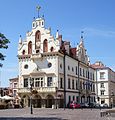 Rzeszówtown hall
 -

-

-
 JasłoPalace
 -
-
 Ignacy ŁukasiewiczMonument inBóbrka
 -
 Royal Casimir Castle inPrzemyśl
 -
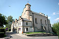 Leskosynagogue
 -
 TarnowskiPalace inTarnobrzeg
 -
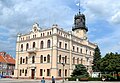 Jarosławtown hall
 -

-

-
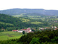
 Solina seen from the distance
 -
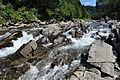 WetlinaRiver
 -

-

-

-

-
 Open air museumin Sanok
 -
-
 TarnicaMountain
 -
 A historicoil well
 -
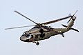 Black Hawk helicoptersare produced byPZL Mielec
 -
 Autosanbus and coach manufacturer has its headquarters in Sanok
 -
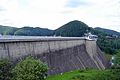 Solina Damis the largest dam in Poland


Curiosities[edit]
- In the 17th century, there was a sizeableScottishcommunity inKrosno.[14]There is a monument toRobert Gilbert Porteousin Krosno, Scottish immigrant, the city's wealthiest 17th-century merchant.[14]
- In 1711,Jarosławwas the place of refuge of Hungarian leaderFrancis II Rákócziand his court, including essayistKelemen Mikes,after the fall of theRákóczi's War of IndependenceagainstAustria.[15]
See also[edit]
References[edit]
- "Central Statistical Office(GUS) - TERYT(National Register of Territorial Land Apportionment Journal)".
 (inPolish). 2008-01-09.Retrieved2008-10-23.
Notes[edit]
- ^"EU regions by GDP, Eurostat".Archivedfrom the original on 27 February 2023.Retrieved18 September2023.
- ^"Sub-national HDI - Subnational HDI - Global Data Lab".globaldatalab.org.Radboud University Nijmegen.Archivedfrom the original on 2023-03-29.Retrieved2023-10-26.
- ^abRozporządzenie Prezydenta Rzeczypospolitej Polskiej z dnia 10 grudnia 2018 r. w sprawie uznania za pomnik historii "Przemyśl - zespół staromiejski",Dz. U. z 2018 r. poz. 2419
- ^GUS."Population. Size and structure and vital statistics in Poland by territorial division in 2019. As of 30th June".stat.gov.pl.Archived fromthe originalon 2021-04-19.Retrieved2020-09-11.
- ^"Regional GDP per capita ranged from 30% to 263% of the EU average in 2018".Eurostat.Archivedfrom the original on 2020-04-17.Retrieved2020-03-07.
- ^"Ethnic composition of Poland".pop-stat.mashke.org.Archivedfrom the original on 2021-11-28.Retrieved2016-05-04.
- ^Kujawiak,Ślązaksimilarly asKrakowiakandMazur,took its name from the region of origin; "Mazowszezasługuje na uwagę ze względu uzdolnień kolonizacyjnych ludności, które to plemię zapędzały na Ruś Czerwoną, w ziemię bialską, więc w sadyby dawnychJadźwingów,naPodole.Wszędzie jednakże swoje plemienne cechy, a chociażby nazwę Mazurzy. Do dziś dnia (Tatomir Geografija Galicji 1876. str. 59) międzyRabąa lewym brzegiem Sanu ludność miejscowa nosi nazwę Mazurów, z których część pod nazwą Grębowiaków (Lisowiaków al. Borowców) siedzi między Wisłą, dolnym Sanem poMielec,iLeżajsk.Mamy zaś ślady, że w 1373 wSanockiemnad Sanem, z daru księciaWładysława Opolczyka,a wówczas pana Rusi (lwowskiej) otrzymał wieśJabłonicęPrzybysław syn Fala zziemi łęczyckiej(AGZt. VII, str. 15-16)... "[w:] Słownik geograficzny Królestwa Polskiego i innych krajów słowiańskich, Tom VI. III. Etnografia i stosunki społeczne. str. 191.
- ^Rozporządzenie Prezydenta Rzeczypospolitej Polskiej z dnia 20 kwietnia 2018 r. w sprawie uznania za pomnik historii "Krasiczyn - zespół zamkowo-parkowy",Dz. U. z 2018 r. poz. 988
- ^Rozporządzenie Prezydenta Rzeczypospolitej Polskiej z dnia 13 kwietnia 2005 r. w sprawie uznania za pomnik historii,Dz. U. z 2005 r. Nr 64, poz. 569
- ^Rozporządzenie Prezydenta Rzeczypospolitej Polskiej z dnia 25 sierpnia 2005 r. w sprawie uznania za pomnik historii "Łańcut - zespół zamkowo-parkowy",Dz. U. z 2005 r. Nr 167, poz. 1402
- ^Rozporządzenie Prezydenta Rzeczypospolitej Polskiej z dnia 10 grudnia 2018 r. w sprawie uznania za pomnik historii "Twierdza Przemyśl",Dz. U. z 2019 r. poz. 159
- ^Rozporządzenie Prezydenta Rzeczypospolitej Polskiej z dnia 22 listopada 2017 r. w sprawie uznania za pomnik historii "Radruż - zespół cerkiewny",Dz. U. z 2017 r. poz. 2253
- ^Maria Jaworska (20 February 2021)."Bálint Balassi w Polsce. Śladami" węgierskiego Jana Kochanowskiego "".Instytut Felczaka Intézet(in Polish).Retrieved3 June2024.
- ^abFeduszka, Jacek (2009). "Szkoci i Anglicy w Zamościu w XVI-XVIII wieku".Czasy Nowożytne(in Polish). Vol. 22. Zarząd Główny Polskiego Towarzystwa Historycznego. p. 53.ISSN1428-8982.
- ^Z Bogiem za ojczyznę i wolność – o Franciszku II Rakoczym bohaterze Węgier(in Polish). Warszawa:Muzeum Niepodległości w Warszawie.2016. p. 30.ISBN978-83-62235-88-9.
External links[edit]
- Subcarpathia photo gallery
- (in Polish)Subcarpathian Voivodeship official website
- (in Polish)Podkarpacki Urząd WojewódzkiOfficial website
- (in English)The castles and palaces of Subcarpathian province
| City counties |
|  |
|---|---|---|
| Land counties | ||
Places adjacent to Subcarpathian Voivodeship | |
|---|---|
49°57′24″N22°10′22″E/ 49.95667°N 22.17278°E
| International | |
|---|---|
| National | |
| Geographic | |
| Other | |