
Surigao del Sur
Surigao del Sur | |
|---|---|
| Province of Surigao del Sur | |
      (from top: left to right) Tinuy-an Falls inBislig,White beach inCagwait,surfer in beach ofLanuza,Hinatuan River,Britania IslandsandSurigao del Sur Provincial Capitol. | |
 Flag  Seal | |
| Nickname: Shangri-La by the Pacific[1] | |
 Location in the Philippines | |
OpenStreetMap  | |
| Coordinates:8°40′N126°00′E/ 8.67°N 126°E | |
| Country | Philippines |
| Region | Caraga |
| Founded | June 19, 1960 |
| Capital | Tandag |
| Largest city | Bislig |
| Government | |
| • Type | Sangguniang Panlalawigan |
| •Governor | Alexander T. Pimentel(PDP–Laban) |
| •Vice Governor | Manuel O. Alameda (Hugpong Surigao Sur) |
| • Legislature | Surigao del Sur Provincial Board |
| Area | |
| • Total | 4,932.70 km2(1,904.53 sq mi) |
| • Rank | 21st out of 81 |
| Highest elevation | 611 m (2,005 ft) |
| Population (2020 census)[3] | |
| • Total | 642,255 |
| • Rank | 47th out of 81 |
| • Density | 130/km2(340/sq mi) |
| • Rank | 66th out of 81 |
| Divisions | |
| •Independent cities | 0 |
| •Component cities | |
| •Municipalities | |
| •Barangays | 309 |
| •Districts | Legislative districts of Surigao del Sur |
| Time zone | UTC+8(PHT) |
| ZIP code | 8300–8318 |
| IDD : area code | +63 (0)86 |
| ISO 3166 code | PH-SUR |
| Spoken languages | |
| Income classification | 1st class |
| Website | www |
Surigao del Sur(Surigaonon:Probinsya nan Surigao del Sur;Cebuano:Habagatang Surigao;Tagalog:Timog Surigao), officially theProvince of Surigao del Sur,is aprovincein thePhilippineslocated in theCaragaregioninMindanao.Its capital isTandag City.Surigao del Sur is situated at the eastern coast of Mindanao and faces thePhilippine Seato the east.
Etymology
[edit]There are two hypotheses on the original meaning of "Surigao" among linguists, depending on the original root word. If the root word was taken to besulig( "sprout" or "spring up" ), then Surigao may have derived from suligao ( "spring water" ), likely referring to the Surigao River (known as "Suligaw" inMandaya) that empties at the northern tip of the island ofMindanao.[4][5]Early historical accounts record the name of the river as Suligao, Surigao, or Zurigan.[6]
Another possibility is that it is derived from Visayan surogao orsuyogao,meaning "water current". Fromsuyog(alsosulogor surog), "current"; cf.Sinulog,Sulu,andTausug(Suluk).[7]
History
[edit]
Early history
[edit]In precolonial times, the region of Surigao was inhabited by theVisayanSurigaononpeople in the coastal areas, as well asLumadgroups in the interiors like theMandaya,Mansaka,MamanwaandManobo.[8]
Spanish colonial era
[edit]During theSpanish Occupationin 1860, six military districts were created in Mindanao, with Surigao and Agusan forming the "East District". In 1870, the district was renamed to "Distrito de Surigao".
American invasion era
[edit]In 1901, Distrito de Surigao becamechartered province.Agusan became anindependent provincein 1907 during theAmerican era,when it was separated from Surigao.[8]
Philippine independence
[edit]Foundation
[edit]Surigao del Sur was created as the 56th Philippine province on June 19, 1960, throughRepublic Act2786,separated from its mother province,Surigao,on September 18, 1960.[9]
At the time of its inception, it was classified as 4th Class province with an annual income of over₱300,000.00. Seven years later, because of rapid increase of revenue collection particularly from the logging ventures, it has been reclassified as Ist Class B and in 1980 as Ist Class A with an estimated annual income of around₱13,000,000. It has been reclassified as 2nd Class with a revenue adding up to₱315,888,300.63.[citation needed]
Recaredo B. Castillo was the appointed first governor and subsequently elected governor while Vicente L. Pimentel was the first elected congressman.
The province was formed with 13 municipalities. Six more were added, raising the number to 19 withTandagas the capital. Two of its municipalities have been elevated to cities; the first wasBisligCity.
Contemporary
[edit]The capital townTandagbecame a component city by virtue ofRepublic Act No. 9392which sought to convert the town into a city. The law was ratified on June 23, 2007. However, the cityhood status was lost twice in the years 2008 and 2010 after theLCPquestioned the validity of the cityhood law. The cityhood status was reaffirmed after thecourtfinalized its ruling on February 15, 2011 which declared the cityhood law constitutional.
House Bill No. 2336 of the 19th Congress seeks to separate the southern part of the province to be formed as the new Province of Surigao Oriental.
Geography
[edit]
Surigao del Sur is located along the northeastern coast ofMindanaofacing thePhilippine Seabetween 125°40' to 126°20' east longitudes and 7°55' and 9°20' north latitudes. It is bounded on the northwest by the province ofSurigao del Norte,on the southeast byDavao Oriental,on the west and southwest byAgusan del NorteandAgusan del Sur.
Situated west is theDiwata Mountain Range,isolating the province from the rest of Mindanao. To the east lies thePhilippine Sea.TheMindanao Deep,one of the deepest trenches in the world, is situated a few kilometers east of the coastline.[10][8]
Land area
[edit]
The land area of the province is 4,932.70 square kilometres (1,904.53 sq mi)[11]representing 27.75 percent of the total land area of Caraga Administrative Region and about 5.14 percent and 1.74 percent of the total land area of Mindanao and Philippines, respectively. The province is elongated in shape, extending from the northeastern portion at Carrascal to the southernmost municipality of Lingig. It is approximately 300 kilometres (190 mi) in length and 50 kilometres (31 mi) at its widest point which runs fromCagwaittoSan Miguel.
Municipal-wise, San Miguel has the biggest land area accounting for11.31% (558 square kilometers) of the total provincial land area whileBayabashas the smallest constituting only about2.39% (117.84 square kilometers).[11]
Of the 5,230.50 square kilometres (2,019.51 sq mi) land, only 1,703.72 square kilometres (657.81 sq mi) or 32.22 percent are classified as alienable and disposable (A and D) while 3,583.523 square kilometres (1,383.606 sq mi) or 67.78 percent are forest land. Tagbina has the biggest share of alienable and disposable land with 234.21 square kilometres (90.43 sq mi) or about 56.51 percent of its land area followed by Hinatuan with 202.52 square kilometres (78.19 sq mi) or 63.56 percent of its land area.[citation needed]
Of the 3,583.523 square kilometres (1,383.606 sq mi) of forest land, 636.076 square kilometres (245.590 sq mi) are protection forest, 2,582.43 square kilometres (997.08 sq mi) production forest, 12.68 square kilometres (4.90 sq mi) are non-forest agriculture and 352.337 square kilometres (136.038 sq mi) are for non-forest mining. As of today, the province still has vast areas of remaining old growth and mossy forest.[citation needed]
Climate
[edit]The province falls under Type IIclimate of the Philippines,characterized by rainfall distributed throughout the year, although there is a distinct rainy season which begins from the month of November and ends in March. However, the climatic behavior of the province for the past few years has shown variations wherein the onset of the rainy seasons no longer occurs on the usual time. Months with low rainfall are from July to October with September as the driest month. Wet months are from November to June with January as the wettest month.
Surigao del Sur is one of the top 20 most vulnerable provinces toclimate change in the Philippines.[12]
| Climate data for Surigao del Sur | |||||||||||||
|---|---|---|---|---|---|---|---|---|---|---|---|---|---|
| Month | Jan | Feb | Mar | Apr | May | Jun | Jul | Aug | Sep | Oct | Nov | Dec | Year |
| Mean daily maximum °C (°F) | 29.6 (85.3) |
30.0 (86.0) |
30.8 (87.4) |
31.6 (88.9) |
32.0 (89.6) |
32.2 (90.0) |
32.3 (90.1) |
32.5 (90.5) |
32.5 (90.5) |
32.2 (90.0) |
31.2 (88.2) |
30.6 (87.1) |
31.5 (88.6) |
| Mean daily minimum °C (°F) | 23.4 (74.1) |
23.2 (73.8) |
23.6 (74.5) |
24.2 (75.6) |
24.4 (75.9) |
24.3 (75.7) |
24.1 (75.4) |
24.3 (75.7) |
24.1 (75.4) |
24.0 (75.2) |
23.9 (75.0) |
23.7 (74.7) |
23.9 (75.1) |
| Average rainy days | 24 | 21 | 20 | 19 | 16 | 16 | 14 | 14 | 13 | 17 | 17 | 21 | 212 |
| Source:Storm247[13] | |||||||||||||
Administrative divisions
[edit]Surigao del Sur comprises 17municipalitiesand twocities,further subdivided into 309barangays.There aretwo congressional districtsencompassing all cities and towns.

- †Provincial capital and component city
- ∗Component city
- Municipality
| ||||||||||||||||||||||||||||||||||||||||||||||||||||||||||||||||||||||||||||||||||||||||||||||||||||||||||||||||||||||||||||||||||||||||||||||||||||||||||||||||||||||||||||||||||||||||||||||||||||||||||||||||||||||||||||||||||||||||||||||||||||||||||||||||||||||||||||||||||||||||||||||||||||
Demographics
[edit]| Year | Pop. | ±% p.a. |
|---|---|---|
| 1903 | 42,346 | — |
| 1918 | 55,421 | +1.81% |
| 1939 | 99,981 | +2.85% |
| 1948 | 109,949 | +1.06% |
| 1960 | 165,016 | +3.44% |
| 1970 | 258,680 | +4.59% |
| 1975 | 302,305 | +3.17% |
| 1980 | 377,647 | +4.55% |
| 1990 | 452,098 | +1.82% |
| 1995 | 471,263 | +0.78% |
| 2000 | 501,808 | +1.36% |
| 2007 | 545,902 | +1.17% |
| 2010 | 561,219 | +1.01% |
| 2015 | 592,250 | +1.03% |
| 2020 | 642,255 | +1.61% |
| Source: Philippine Statistics Authority[14][15][16] | ||
The population of Surigao del Sur in the 2020 census was 642,255 people,[3]with a density of 130 inhabitants per square kilometre or 340 inhabitants per square mile.
The province is home to theKamayoandAgusan people.Their dances are showcased in the local festival, "Sirong Festival",held especially during the town fiesta ofCantilan.The Sirong Festival depicts the early Christianization of the early Cantilan inhabitants where the natives tried to defend their land against Visayan invaders.
The indigenous people of the province were largely Christianized during the early times of the Spanish conquest.
Languages
[edit]TheSurigaononandTandaganonlanguages are spoken in most parts of Surigao del Sur (except inBisligand the towns ofBarobo,Hinatuan,LingigandTagbina,where most of the inhabitants speakCebuanoand their nativeKamayo,a different language but one distantly related to Surigaonon, is spoken by the rest of the population), with the Cantilangnon dialect, a northern variety of Surigaonon that is very much similar to the dialect of Surigaonon as spoken in Surigao del Norte, being spoken mostly in the five northern municipalities of the province, namelyCarrascal,Cantilan,Madrid,CarmenandLanuza(or the municipal cluster calledCarcanmadcarlan); these municipalities were once under a single Municipality of Cantilan before December 10, 1918.
Tagalog and English are also widely spoken throughout the province and used as the primary languages of education, business, and administration.
Economy
[edit]
Surigao del Sur is one of the suppliers of rice, bananas and other tropical fruits. Copper, chromite and silver are also found here. Marine and aquaculture are abundant in the province, being primary livelihoods of the inhabitants as the province is well known for producing seafood and sea by-products.
Mineral resources
[edit]Surigao del Sur is endowed with metallic minerals such ascopper,gold,chromite,cobalt,nickeland lead zinc, as well as non-metallic (limestone,coalandfeldspar,clay diatomite/bentomite and coarse/fine aggregates). There are small and large scale mining activities in the province. Corporations operating in a large scale are the Marc Ventures Mining Development Corporation at Carrascal and Cantilan, operating in an area of 4,799 hectares (47.99 km2) within theDiwata Mountain Range.[24][25]The [TP Construction and Mining Corporation, also in Carrascal, focuses on gold and nickel mining in an area of 35.64 square kilometres (13.76 sq mi) and 48.6916 square kilometres (18.80 sq mi), respectively. The Carac-an Development Corporation, also in Carrascal, has an area of 506.3764 square kilometres (195.51 sq mi). Small scale mining activities are found in the municipalities of Barobo, Carmen and San Miguel.
Tourism
[edit]Bislig's main tourist attraction is theTinuy-an Falls,[26]known as the little "Niagara Fallsof the Philippines ". It is a white water curtain that flows in three levels about 55 metres (180 ft) high and 95 metres (312 ft) wide.[27]Its unique natural formation once appeared in the International Travel Magazine. It is also known as the widest waterfall in the Philippines.[citation needed]
Surfingin Surigao del Sur is widely known and has been one of the local tourist attractions. Thisextreme sportis often practiced inCantilanandLanuza.[28]Skimboardingis also found in several municipalities, attracting tourists.
-
 Deep-blue waters of the renowned "Hinatuan Enchanted River",an underground river in Barangay Talisay, Hinatuan
 -
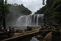 The Tinuy-an Falls in Burboanan, Bislig
 -
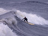 Surfing in Lanuza

See also
[edit]References
[edit]- ^Caraganon.com
- ^"List of Provinces".PSGC Interactive.Makati, Philippines: National Statistical Coordination Board.RetrievedApril 1,2014.
- ^abcCensus of Population (2020).Table B - Population and Annual Growth Rates by Province, City, and Municipality - By Region.Philippine Statistics Authority.RetrievedJuly 8,2021.
- ^Philippine Institute of Traditional and Alternative Health Care, Department of Health; University of the Philippines Manila; University of the Philippines Mindanao (2000)."Ethnomedical documentation of and community health education for selected Philippine ethnolinguistic groups: the Mandaya people of Davao Oriental, Philippines"(PDF).RetrievedApril 22,2015.[permanent dead link]
- ^Benito Francia y Ponce de Leon; Julián González Parrado (1898).La Islas Filipinas. Mindanao, Volume 1.Subinspección de Infantería. p. 197.
- ^Pio A. De Pazos y Vela-Hidalgo, ed. (1879).Jolo, Relato Historico-Militar: Desde Su Descubrimiento Por Los Espanoles en 1578 A Nuestros Dias (1879).Imprenta y Estereotipia de Polo.
- ^Paredes, Francis Tom; Paredes, Sheila (2017).The Monosyllabic root -ao in Mindanao Languages.8th Annual In-house Review of the Research Office of Agusan del Sur State College of Agriculture and Technology. Agusan del Sur State College of Agriculture and Technology.
- ^abcLancion, Conrado M. Jr. (1995). "The Provinces; Surigao del Sur".Fast Facts about Philippine Provinces.cartography by de Guzman, Rey (The 2000 Millenium ed.). Makati, Metro Manila, Philippines: Tahanan Books. p. 156.ISBN971-630-037-9.RetrievedApril 28,2016.
- ^"Republic Act No. 2786 - An Act to Create the Provinces of Surigao del Norte and Surigao del Sur".Chan Robles Virtual Law Library.June 19, 1960.RetrievedJanuary 11,2016.
- ^"Philippine Provincial Profile; Surigao del Sur".OoCities.org.RetrievedApril 28,2016.
- ^abcd"Province: Surigao del Sur".PSGC Interactive.Quezon City, Philippines:Philippine Statistics Authority.RetrievedJanuary 8,2016.
- ^"About Caraga".National Economic and Development Authority Caraga.RetrievedMay 13,2022.
- ^"Weather forecast for Surigao del Sur, Philippines".Storm247.com.Bergen, NO:StormGeo AS.RetrievedApril 29,2016.
- ^abCensus of Population (2015).Highlights of the Philippine Population 2015 Census of Population.Philippine Statistics Authority.RetrievedJune 20,2016.
- ^Census of Population and Housing (2010).Population and Annual Growth Rates for The Philippines and Its Regions, Provinces, and Highly Urbanized Cities(PDF).National Statistics Office.RetrievedJune 29,2016.
- ^Census of Population and Housing (2010)."Caraga"(PDF).Total Population by Province, City, Municipality and Barangay.National Statistics Office.RetrievedJune 29,2016.
- ^"Poverty incidence (PI):".Philippine Statistics Authority.RetrievedDecember 28,2020.
- ^"Estimation of Local Poverty in the Philippines"(PDF).Philippine Statistics Authority. November 29, 2005.
- ^"Annual Per Capita Poverty Threshold, Poverty Incidence and Magnitude of Poor Population, by Region and Province: 1991, 2006, 2009, 2012 and 2015".Philippine Statistics Authority. August 27, 2016.
- ^"Annual Per Capita Poverty Threshold, Poverty Incidence and Magnitude of Poor Population, by Region and Province: 1991, 2006, 2009, 2012 and 2015".Philippine Statistics Authority. August 27, 2016.
- ^"Annual Per Capita Poverty Threshold, Poverty Incidence and Magnitude of Poor Population, by Region and Province: 1991, 2006, 2009, 2012 and 2015".Philippine Statistics Authority. August 27, 2016.
- ^"Updated Annual Per Capita Poverty Threshold, Poverty Incidence and Magnitude of Poor Population with Measures of Precision, by Region and Province: 2015 and 2018".Philippine Statistics Authority. June 4, 2020.
- ^"2021 Full Year Official Poverty Statistics of the Philippines"(PDF).Philippine Statistics Authority. August 15, 2022.RetrievedApril 28,2024.
- ^"Marcventure's mining operations in Cantilan, Surigao del Sur, Philippines".Environmental Justice Atlas.RetrievedApril 18,2016.
On July 1, 1993, Marcventure Mining and Development Corporation (MMDC) received a mining permit covering 4,799ha, located in the Diwata Mountain Range, Cantilan, Surigao del Sur.
- ^Galvez, James Konstantin (April 24, 2014)."DENR shuts down Surigao del Sur mining firm".The Manila Times.RetrievedApril 18,2016.
MMDC, a subsidiary of publicly listed Marcventures Holdings Inc., is engaged in nickel production in Surigao del Sur. The company holds a mineral production sharing agreement (MPSA) for a 4,799- hectare tenement located in Cantilan, Surigao del Sur.
- ^Crismundo, Mike (September 22, 2015)."Caraga tourist arrivals to reach 2M by end of 2015".Manila Bulletin.RetrievedApril 18,2016.
Frequently visited by this huge volume of tourists are the famous "Cloud 9" and amazing beach resorts and islets in Siargao Island, the Sohoton Cove in Bucas Grande Island in Socorro town, the game fishing hub in Pilar, all in Siargao Island in Surigao del Norte, the Enchanted River in Hinatuan, Surigao del Sur, the Tinuy-an Falls in Bislig City and Balanghai in Butuan City.
- ^Alcantara, Jojie (February 11, 2005)."Tinuy-an Falls: Our little Niagara".Sun.StarDavao.Archived fromthe originalon April 28, 2005.RetrievedApril 18,2016.
Tinuy-an is a three-tiered falls (there is a fourth but cannot be seen from view) about 55 meters high and a breathtaking width of 95 meters, supposedly the widest in the country.
- ^Mascariñas, Erwin (November 11, 2012)."LGU wants to make Cantilan a surfing destination".MindaNews.Mindanao News and Information Cooperative Center.RetrievedApril 28,2016.
External links
[edit] Media related toSurigao del Surat Wikimedia Commons
 Geographic data related toSurigao del SuratOpenStreetMap
- Local Governance Performance Management SystemArchivedMarch 4, 2016, at theWayback Machine
- Surigao del Sur provincial profile at Philippine Provincial Profiles
Places adjacent to Surigao del Sur | ||||||||||||||||
|---|---|---|---|---|---|---|---|---|---|---|---|---|---|---|---|---|
| ||||||||||||||||
Tandag(capital) | |
| Municipalities | |
| Component cities | |

| International | |
|---|---|
| National | |