
Surin province
This articleneeds additional citations forverification.(May 2015) |
Surin
สุรินทร์(Thai) | |
|---|---|
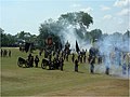
From top; left to right:Prasat Ta Muen Thom,The Monument of Phaya Surin Phakdi Si Narong Changwang, Wat Burapharam, Surin City Pillar Shrine,Surin Elephant Round-up. | |
 Flag  Seal | |
| Nickname(s): Mueang Chang (lit. 'City of Elephants') | |
| Motto(s): สุรินทร์ ถิ่นช้างใหญ่ ผ้าไหมงาม ประคำสวย ร่ำรวยปราสาท ผักกาดหวาน ข้าวสารหอม งามพร้อมวัฒนธรรม ( "Surin. Home of large elephants. Beautiful silk and prayer beads. Rich in (stone) castles. Sweet radishes. Fragrant rice. Fascinating culture." ) | |
 Map of Thailand highlighting Surin province | |
| Country | Thailand |
| Capital | Surin |
| Government | |
| • Governor | Suvapong Kitiphatpiboon (since October 2020)[1] |
| Area | |
| • Total | 8,854 km2(3,419 sq mi) |
| • Rank | Ranked 22nd |
| Population (2019)[3] | |
| • Total | 1,396,831 |
| • Rank | Ranked 12th |
| • Density | 157/km2(410/sq mi) |
| • Rank | Ranked 26th |
| Human Achievement Index | |
| • HAI (2022) | 0.5935 "low" Ranked 77th |
| GDP | |
| • Total | baht73 billion (US$2.4 billion) (2019) |
| Time zone | UTC+7(ICT) |
| Postal code | 32xxx |
| Calling code | 044 |
| ISO 3166 code | TH-32 |
| Website | surin.go.th |


Surin(Thai:สุรินทร์,pronounced[sù.rīn];Northern Khmer:ซเร็น,pronounced[sren];Kuy:สุลิน) is one of Thailand's seventy-sevenprovinces(changwat). It lies inlower northeastern Thailand,also calledIsan.Neighboring provinces are (from west clockwise)Buriram,Maha Sarakham,Roi Et,andSisaket.To the south it bordersOddar MeancheayofCambodia.Surin covers a total area of 8,124 km2(3,137 sq mi) from theMun Riverin the north to theDangrek Mountainsin the south. The capital,Surin city,in the western central region province is434 kmfrom Bangkok.[6]
The area of present-day Surin has long history of human settlement which dates back to prehistoric times. Historically the region has been ruled by various powerful kingdoms including theAngkorianKhmer Empire,the Lao kingdomLan Xang,and the Thai kingdom ofAyutthaya.Reflecting this history as part the greater geo-cultural area of Thailand known as Isan, Surin is ethnically diverse. The primary language is the Isandialect of Lao.Speakers of Central Thai account for a small minority while nearly 50% of the population are ethnicKhmer.The remainder are speakers of various Lao languages and small tribal groups such as theKuyandNyah Kur.
The northeast provinces have traditionally been isolated, both physically and culturally, from the rest of Thailand and Surin is no exception. The vast majority of the province is rural and relatively poor. There is little industrial development with rice farming being the primary industry. Rice farmers supplement their income by cutting sugar cane, as construction laborers, or working in the local silk weaving trade.[7]Elephant capture and training is also an important industry in Surin. Approximately 25 percent of all the elephants in the kingdom are raised in Surin, predominantly by the ethnicKuypeople.[8]
Tourism is also important to the Surin economy. Elephants and scenery are increasingly seen as potentially lucrative by the provincial government which has attempted to make Surin a popular destination for internationalecotourism.[8]Domestically, Surin has a reputation for its fine silk and silver beaded ornaments produced in tourist-focused villages such as Khwao Sinaring Handicraft Village. Local traders also conduct cross-border commerce with Cambodians through a border crossing atChong Chom,70 kmsouth of Surin city.[9]


Name
[edit]According to legend, the province was given its current name in 1786 in honor of its royal governor, Chiangpum, whose royal title wasLuang Surin Phakdi.TheSurinportion of the title is a compound of two words, สุระ and อินทร์, derived from theSanskritwordssura(Devanagari:सुर), meaning 'god' (cf.Asura), andIntar(Devanagari:इन्द्र),Indra.[10]
Prior to the 14th century, the area was part of theKhmer empirein its province ofKok Khan(Khmer:គោកខណ្ឌ).[11]The name of the region during the period after the fall of the Khmer Empire until acquiring its current name has been lost to history.[10]
Geography
[edit]Surin lies at the center of the southern edge of theKhorat Plateau,a relatively low-lying interior region isolated from the rest of Southeast Asia by surrounding mountain ranges. The south of the province is dominated by theDongrek mountain range,theescarpmentof which demarcates the watershed boundaries and also forms the international border with Cambodia. The mountains, averaging approximately 500m in elevation, are not particularly high but the southward sides are steep cliffs rising rather abruptly from the northern plains of Cambodia significantly hindering any attempt at passing. The main pass in the region is in Surin and cuts through the mountains between Chong Chom andO Smach,Cambodia.
The northern face of the mountain range slopes gently down leveling out into the rolling flood plains that make up the central and northern regions of Surin. These areas are drained by small meandering streams which run roughly south-to-north and drain into theMun River,which cuts through the extreme north of the province flowing east to eventually empty into theMekong.As the third longest river in Thailand and second largest by volume of water, the Mun has been important in the region since prehistoric times.
The northwestern area of Surin is a panhandle that juts westward into Buriram province at the confluence of the Mun with Chi Creek (Thai:ห้วยชี), which flows down from the Dangrek mountains, passing just west of the provincial capital of Surin city, and forms most of the western provincial border between Surin and Buriram. The Mun river valley forms the southern provincial border of this panhandle before extending somewhat diagonally northeast, opening up into a large lake near Tha Tum. Leaving the lake, the Mun continues on to meet the provincial border with Roi Et province just west of Road 215, effectively cutting off the mainly agricultural panhandle area from the rest of Surin. From there, the Mun River continues eastward forming the northern provincial boundary of Surin all the way to the confluence with the Thap Than Creek (Thai:ห้วยทับทัน) that forms the eastern border of Surin with Sisaket province.
The total forest area is 748 km2(289 sq mi) or 8.4 percent of provincial area.[2]
Wildlife sanctuary
[edit]There is one wildlife sanctuary, along with five other wildlife sanctuaries, make upregion 9 (Ubon Ratchathani)of Thailand's protected areas.
- Huai Thap Than–Huai Samran Wildlife Sanctuary,501 km2(193 sq mi)[12]: 9
Administrative divisions
[edit]
Provincial government
[edit]The province is divided into 17 districts (amphoes). The districts are further divided into 158 subdistricts (tambons) and 2011 villages (mubans).
Local government
[edit]As of 26 November 2019 there are:[13]one Surin Provincial Administration Organisation (ongkan borihan suan changwat) and 28 municipal (thesaban) areas in the province. Surin has town (thesaban mueang) status. Further 27 subdistrict municipalities (thesaban tambon). The non-municipal areas are administered by 144 Subdistrict Administrative Organisations - SAO (ongkan borihan suan tambon).[3]
Climate
[edit]Due to its position in the Khorat Plateau, the climate of Surin is largely affected by the surrounding mountains which block much of the rain that would otherwise be carried to the province by themonsoons.This results in lower annual rainfall totals and greater differences between the rainy and dry seasons than areas outside the plateau.
History
[edit]Prehistory
[edit]Archaeological sites in the Khorat Plateau have provided some of the earliest evidence of pottery, metallurgy and developed wet rice cultivation in Southeast Asia. The Mun river valley and surrounding basin has supported rice growing cultures since prehistoric times.[14]The earliest settlers in the region were hunter-gatherers. The Neolithic period, which saw the introduction of agriculture, dates from 2,500 to 1,500 years BCE. The Bronze Age follows from 1,500 to 500 BCE, and the Iron Age from 500 BCE to 500 CE. The first evidence of human settlement in Surin emerges in the Iron Age, with approximately 60 known Iron Age sites. These prehistoric settlers are assumed to be ancestors of the various Mon-Khmer peoples prevalent in the area today.[15]
Historical period
[edit]
The earliest known historical period is theDvaravati.This was an Indian-based culture, which defused through the northeast region of what is now Thailand. Evidence of this culture is found in Surin region dating to between the 7th–11th centuries CE. It was in this period that Buddhism became the dominant religion of the region.
Following the Dvaravati period, the powerfulKhmer Empireexpanded its influence throughout what is now the southern Isan region of Thailand. This period covers the 7th–13th centuries CE. Surin was an important part of the ancient Khmer empire. Temple ruins and a substantial ethnicKhmerminority remain part of Surin. Khmer stone inscriptions date from c. 600 CE. Over the next several centuries a growing number of Khmer sites were constructed in the province, most notablyPrasat Sikhoraphum.These sites would have formed part of the network of Khmer infrastructure centred on Prasat Phanom Rung.
With the collapse of the Khmer empire in the 15th century, Surin faded from history, not to re-emerge until the 18th century. According to legend, a localKuayleader named Chiangpum presented a rarewhite elephantto Chao Phaya Chakri, the future KingRama I.In gratitude, he awarded Chiangpum the royal titleLuang Surin Phakdiand appointed him village headman. When he became monarch, Rama I named Luang Surin Phakdi as the provincial governor. In 1763 Chiangpum's village moved 15 kilometers to its present location and was upgraded to a city namedMuang Prathai Saman.According to tradition, the move was due to better water at the new site. In 1786 the name was changed to Surin in honor of its royal governor.
The province slowly grew as people returned to the area. Although there was a continual influx of people from the surrounding areas, Surin was largely self-sufficient and remained somewhat isolated until the arrival of the railroad in 1922. Chinese and Indian merchants settled in the city, manufacturing increased, and Surin gradually became a modern metropolis.
Culture
[edit]
As in most of Isan, the primary culture of Surin is that of the ethnicLao peoplewho inhabit the region.[16]Within Thailand, the preferred nomenclature for this culture is "Thai-Isan" to enforce their identity as Thai citizens and differentiate them from the Lao ofLaos,but the culture of the region is markedly different from central Thais. The Isan language is a dialect of Lao, although mutually intelligible with central Thai. The Thai-Isan of Surin are associated with Lao dress, Lao-influenced music (e.g., thekheneandmor lam) and Lao-style cuisine, which includessticky ricein contrast to thejasmine ricepreferred by central Thais.[16]
Due to Surin's significant Khmer population, aspects ofNorthern Khmerculture are also common in the province including theNorthern Khmer languageand theirkantrumandchrieng brunhmusic forms. The historical impact of the Khmer on the culture of the region is evident in the numerous Khmer temples and ruins that dot the landscape of Surin. As the Khmer prefer jasmine rice, much of Surin's rice production is geared toward this crop.
The culture of Surin is also strongly influenced by the Kuy people, most visibly in the activity surroundingelephantsthat is so prominent in the province. Surin is the source of approximately a quarter of all domesticated elephants in Thailand and the capture, training, and raising of these elephants is conducted by people of Kuy ethnicity.[8]This is such an important activity to Surin and a source of pride to the Kuy people, that celebrations such as Thai Elephant Day (Thai:งานวันช้างไทย) and theSurin Elephant Round-upare held annually on the second and third weeks, respectively, of November. The festivals include light and sound shows describing the legends of the Thai elephants and a fair at Si Narong Stadium featuring parades, floats, contests such as tug of war between elephants and men and demonstrations of war elephants.
Symbols
[edit]Theprovincial sealis an image ofIndraatop his celestial whiteelephant,Airavatawhich is based on the design found on a famous Khmer temple in the province. Both Khmer temples and elephants are commonly found in Surin.
Theprovincial treeand flower is the commontembusu(Fagraea fragrans).Smallscale mud carp(Cirrhinus microlepis) is a provincial fish.[17]
Economy
[edit]
Surin province produces high-quality jasmine rice.[18]It is also known for its silk. This quality is due to its weaving process, as well as its patterns and dyes.[19]
Demographics
[edit]In Thailand's 2000 census it was reported that 99.5 percent of the province's population were Thai nationals; 29.3 percent of the population ranged from age 0–14, 60.9 percent ranged from 15 to 59, and 9.8 percent of the population is 60 and over.[citation needed]
Surin is a province with a sizableNorthern Khmerpopulation. It was reported that 47.2 percent of the population are capable of speaking theKhmer language.This is down from the 1990 census where it was reported that 63.4 percent of the population spoke Khmer.[20]
A third large minority group, theKuy people,also reside in Surin. Also spelled "Guay", "Suai" or "Kha" (pejoratively), the Kuy are aMon-Khmerpeople distantly related to the Khmer and considered by many Thais to be the aboriginal inhabitants of the region. A 1985 study found that 9.6 percent of the people in Surin were Kuy, 9.2 percent were mixed Lao-Kuy, and 3.1 percent were mixed Khmer-Kuy.[citation needed]Kuy people speak theKuy languageand most traditionally followed animist beliefs although asyncreticblend of animism with the local Theravada Buddhism is now more common.
Human achievement index 2022
[edit]| Health | Education | Employment | Income |
| 70 | 65 | 58 | 77 |
| Housing | Family | Transport | Participation |

|
 |

|

|
| 14 | 46 | 59 | 52 |
| Province Surin, with an HAI 2022 value of 0.5935 is "low", occupies place 77 in the ranking. | |||
Since 2003, United Nations Development Programme (UNDP) in Thailand has tracked progress on human development at sub-national level using theHuman achievement index(HAI), a composite index covering all the eight key areas of human development. National Economic and Social Development Board (NESDB) has taken over this task since 2017.[4]
| Rank | Classification |
| 1 - 13 | "high" |
| 14 - 29 | "somewhat high" |
| 30 - 45 | "average" |
| 46 - 61 | "somewhat low" |
| 62 - 77 | "low" |
| Map with provinces and HAI 2022 rankings |

|
Notable people
[edit]
- Tony Jaa:Martial arts movie star ofKuydescent
- Buakaw Banchamek:world-classMuay Thaikickboxer ofKuydescent
- Thammanoon Niyomtrong:world-class professional boxer
- Elephant Festival
-
-


References
[edit]- ^"ประกาศสำนักนายกรัฐมนตรี เรื่อง แต่งตั้งข้าราชการพลเรือนสามัญ"[Announcement of the Prime Minister's Office regarding the appointment of civil servants](PDF).Royal Thai Government Gazette.137(Special 194 Ngor). 33. 24 August 2020. Archived fromthe original(PDF)on August 25, 2020.Retrieved13 April2021.
- ^ab"ตารางที่ 2 พี้นที่ป่าไม้ แยกรายจังหวัด พ.ศ.2562"[Table 2 Forest area Separate province year 2019]. Royal Forest Department (in Thai). 2019.Retrieved6 April2021,information, Forest statistics Year 2019, Thailand boundary from Department of Provincial Administration in 2013
{{cite web}}:CS1 maint: postscript (link) - ^abรายงานสถิติจำนวนประชากรและบ้านประจำปี พ.ส.2562[Statistics, population and house statistics for the year 2019]. Registration Office Department of the Interior, Ministry of the Interior.stat.bora.dopa.go.th(in Thai). 31 December 2019.Retrieved26 February2020.
- ^ab"ข้อมูลสถิติดัชนีความก้าวหน้าของคน ปี 2565 (PDF)"[Human Achievement Index Databook year 2022 (PDF)]. Office of the National Economic and Social Development Council (NESDC) (in Thai).Retrieved12 March2024,page 82
{{cite web}}:CS1 maint: postscript (link) - ^"Gross Regional and Provincial Product, 2019 Edition".<>.Office of the National Economic and Social Development Council (NESDC). July 2019.ISSN1686-0799.Retrieved22 January2020.
- ^"From Bangkok to Surin".Google Maps.Retrieved12 May2015.
- ^Behnassi, Mohamed; Shahid, Shabbir; D'Silva, Joyce, eds. (2011).Sustainable Agricultural Development: Recent Approaches in Resources Management and Environmentally-Balanced Production Enhancement.Springer Science & Business Media. p. 188.ISBN9789400705197.
- ^abcPongsak, Nakprada."The 'Elephants Return to Homeland' Project Management for Provincial Economic Development in Surin province"(PDF).The Government of Thailand. Archived fromthe original(PDF)on 18 May 2015.Retrieved12 May2015.
{{cite journal}}:Cite journal requires|journal=(help) - ^"Royal Thai Government website".Archived fromthe originalon 2021-10-09.Retrieved2015-05-12.
- ^ab"History of Surin".Government of the province of Surin(in Thai). Government of Thailand. Archived fromthe originalon 18 May 2015.Retrieved12 May2015.
- ^Nath, Chuon. "Dictionnaire cambodgien." Edition de L’Institut Bouddhique, Phnom Penh (1967).
- ^"ตาราง 5 พื้นที่เขตรักษาพันธุ์สัตว์ป่า พ.ศ. 2562"[Table 5 Wildlife Sanctuary Areas in 2019](PDF).Department of National Parks, Wildlife Sanctuaries and Plant Conservation (in Thai). 2019.Retrieved1 November2022.
- ^"Number of local government organizations by province".dla.go.th.Department of Local Administration (DLA). 26 November 2019.Retrieved10 December2019.
68 Surin: 1 PAO, 1 Town mun., 27 Subdistrict mun., 144 SAO.
- ^Grabowsky, Volker, ed. (1995).Regions and National Integration in Thailand, 1892-1992.Otto Harrassowitz Verlag.ISBN9783447036085.
- ^Baker, Chris (2005).A History of Thailand.Cambridge University Press.ISBN9780521016476.
- ^abVail, Peter. "Thailand's Khmer as 'invisible minority': Language, ethnicity and cultural politics in north-eastern Thailand"Asian Ethnicity8.2 (2007): 111-130.
- ^Suraset Meesin (story) and Editorial Team (photos), ปลาเด็ด 77 จังหวัด #6 (Cool fish in 77 provinces #6), Aquarium Biz, Vol. 4 Issue 43 (January 2014)Thai:ภาษาไทย
- ^Richards, Matthew (2013-09-06)."Surin - Thailand's Rice Heartland".Demotix.Archived fromthe originalon 23 September 2015.Retrieved27 July2015.
- ^"Surin".Tourism Authority of Thailand (TAT).Archived fromthe originalon 6 September 2015.Retrieved27 July2015.
- ^"(Surin) Key indicators of the population and household, population and housing census 1990 and 2000."Population and Housing Census 2000Archived2012-02-15 at theWayback Machine.(retrieved 14 July 2009)
Further reading
[edit]- Childress, Vance Ray.Proposal: The Complete Excavation of Prasat Ban Pluang Prasat District, Surin Province, Thailand.Tulsa: Soday Research Foundation, 1975.
- Guide to Surin National Museum.Office of the National Museums, The Fine Arts Department, Ministry of Culture. 2009.
External links
[edit] Surintravel guide from Wikivoyage
Places adjacent to Surin province | |
|---|---|
| International | |
|---|---|
| National | |
| Geographic | |
| Other | |