
Swat River
| Swat River سوات | |
|---|---|
 | |
 Course of the Swat (interactive map) | |
| Location | |
| Country | |
| Province | |
| District | Swat |
| Physical characteristics | |
| Source | Hindu KushMountains |
| Source confluence | UshoandGabralrivers |
| • location | Kalam |
| Mouth | Kabul River |
• location | Charsadda |
| Length | 240 km (150 mi) |
| Basin size | 13,000 km2(5,000 sq mi) |
| Discharge | |
| • location | Munda |
| • average | 280 cubic m/s |
| Basin features | |
| Tributaries | |
| • left | Ushu Khwar, Bashigram Khwar |
| • right | Daral Khwar, Gabral Khwar |
TheSwat River(Urdu:دریائے سوات,Pashto:سوات سیند) is a perennial river in the northern region of theKhyber-PakhtunkhwaProvince ofPakistan.The river's source is in the high glacial valleys of theHindu Kushmountains, where it then flows into theKalam Valleybefore forming the spine of the widerSwat Valley.
Name
[edit]The word Swat is a Sanskrit name which may[ambiguous]mean "clear blue water."[1]Another theory derives the word Swat from the Sanskrit wordshveta(lit. 'white'), also used to describe the clear water of the Swat River.[2]To the ancient Greeks, the river was known as theSoastus.[3][4][5][2]The Chinese pilgrimFaxianreferred to Swat as theSu-ho-to.[6]
Course
[edit]The Swat's source lies in theHindu Kushmountains, from where it is fed by glacial waters throughout the year. From the high valleys of Swat Kohistan, the river begins at the confluence of theUsho,andGabralrivers (also known as the Utrar River) at Kalam. From the confluence, the Swat river flows through the narrow gorges of theKalam Valleyuntil the city ofMadyan.From there, the river courses gently for 160 km (99 mi) through the plain areas of the lowerSwat ValleyuntilChakdara.In the extreme southern end of the Swat valley, the river enters a narrow gorge and joins thePanjkora River,at Qalangi before entering thePeshawar Valley.It finally terminates inKabul River,nearCharsadda.
Discharge
[edit]The average discharge at Munda is 280 cubic metres (9,900 cu ft) per second.[7]
Economic impact
[edit]Swat River plays an important role in the economy of the valley. Lower reaches of the Swat andMalakandValley are irrigated by a series of canals regulated by the Amandara Headworks - built by the British in 1903.[8]
TheUpper Swat Canalflows under theMalakand Passthrough Benton Tunnel, completed in 1914. BelowDargai,the Munda Headworks, built by the British in 1921,[9]feed canals that supply numerous smaller canals in the districts ofCharsadda,SwabiandMardanin thePeshawar Valley.The river also recharges water wells and springs through seepage.
Hydropower
[edit]Swat's waters are used forhydropowergeneration at theJabban Hydropower Plant(completed in 1938), andDargai Hydropower Plant(completed in 1952). TheMohmand Dam,at the lower end of the Swat River's course before it enters into thePeshawar valley,has an installed generation capacity of 740 MW and is under construction.[10]Proposed hydropower projects along the river's course are Asrit Kedam HPP,[11]Gabral HPP[12]andMatiltan HPP.[13]
Gallery
[edit]-
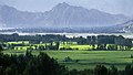
 Upper reaches of the Swat River in theKalam Valley
 -
 The town ofBahrain,built along the river
 -
 Lower reaches of the Swat River valley
 -
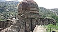 TheAmluk-Dara stupa,one of many ancient Buddhist sites scattered throughout the river's valley


See also
[edit]References
[edit]- Book: Hidden Treasures of Swat,ISBN978-969-23042-0-7
- ^Susan Whitfield(2018).Silk, Slaves, and Stupas: Material Culture of the Silk Road.University of California Press. p. 136.ISBN978-0-520-95766-4.
- ^abSultan-i-Rome (2008).Swat State (1915–1969) from Genesis to Merger: An Analysis of Political, Administrative, Socio-political, and Economic Development.Oxford University Press. p. 13.ISBN978-0-19-547113-7.
- ^Edward Herbert Bunbury (1879).A history of ancient geography among the Greeks and Romans.J. Murray.
- ^Arrian (14 February 2013).Alexander the Great: The Anabasis and the Indica.OUP Oxford.ISBN978-0-19-958724-7.
- ^Saxena, Savitri (1995).Geographical Survey of the Purāṇas: The Purāṇas, a Geographical Survey.Nag Publishers.ISBN978-81-7081-333-0.
- ^Rienjang, Wannaporn; Stewart, Peter (15 March 2019).The Geography of Gandhāran Art: Proceedings of the Second International Workshop of the Gandhāra Connections Project, University of Oxford, 22nd-23rd March, 2018.Archaeopress.ISBN978-1-78969-187-0.
- ^"Feasibility study on the development of Munda Dam multipurpose project in Islamic Republic of Pakist an: final report; Vol. 3. -Supporting report"(PDF).Japan International Cooperation Agency: Nippon Koei Co., Ltd.: Nippon Giken Inc.Archived(PDF)from the original on 7 October 2022.
- ^"History".www.wapda.gov.pk.Retrieved22 April2021.
- ^Report, Bureau (28 August 2010)."Munda Headworks restored in record time".DAWN.COM.Retrieved22 April2021.
- ^[1][dead link]
- ^"Korean companies asked to undertake $1.6bn of hydroelectric schemes in Pakistan".Global Construction Review.8 January 2021.Retrieved7 October2021.
- ^"Pre-qualification bids sought for E&M supply for Gabral Kalam, Pakistan… | Hydropower & Dams International".www.hydropower-dams.com.Retrieved7 October2021.
- ^Poindexter, Gregory (5 December 2016)."Pakistan begins construction of the 84-MW Matiltan hydropower project".Hydro Review.Retrieved7 October2021.
External links
[edit]34°07′N71°43′E/ 34.117°N 71.717°E
| International | |
|---|---|
| National | |