
Syria vilayet
| Vilayet of Syria ولايت سوريه(in Ottoman Turkish) Vilâyet-i Sûriye ولاية سوريا(in Arabic) | |||||||||||||
|---|---|---|---|---|---|---|---|---|---|---|---|---|---|
| Vilayetofthe Ottoman Empire | |||||||||||||
| 1865–1918 | |||||||||||||
 Flag | |||||||||||||
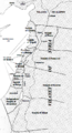
 Vital Cuinet's 1896 map of Syria, showing the Syria Vilayet divided into the sanjaks ofHama,Damascus,HauranandMa'an | |||||||||||||
| Capital | Damascus | ||||||||||||
| Population | |||||||||||||
• 1897[1] | 701,812 | ||||||||||||
| History | |||||||||||||
• Established | 1865 | ||||||||||||
• Disestablished | 1918 | ||||||||||||
| |||||||||||||
| Today part of | Syria Jordan | ||||||||||||
TheVilayet of Syria[2](Arabic:ولاية سوريا;Ottoman Turkish:ولايت سوريه,romanized:Vilâyet-i Sûriye),[3]also known asVilayet of Damascus,[4]was a first-level administrative division (vilayet) of theOttoman Empire.
At the beginning of the 20th century, it reportedly had an area of 62,180 square kilometres (24,009 sq mi), while the preliminary results of the first Ottoman census of 1885 (published in 1908) gave the population as 1,000,000.[5]The accuracy of the population figures ranges from "approximate" to "merely conjectural" depending on the region from which they were gathered.[5]
History
[edit]In 1864, theVilayet Lawwas promulgated.[6]The new provincial law was implemented inDamascusin 1865, and the reformed province was named Suriyya/Suriye, reflecting a growing historical consciousness among the local intellectuals.[6]Jerusalem was separated from the rest of the province, and made into an independentsanjak of Jerusalemthat reported directly toIstanbul,rather than Damascus.Mount Lebanonhad been similarly made into a self-governingmutesarrifatein 1864.[6]
In 1872, a new administrative region was created, with its center inMa'an,but the costs for the new administrative unit far outweighed the revenues, and it was closed the following year.[7]In 1884, the governor of Damascus made a proposal to establish a new vilayet ofsouthern Syria,though nothing came out of this.[7]
In 1888, avilayet of Beirutwas formed from the coastal areas of the vilayet of Syria.[6][8]In May 1892, another proposal was made for a regional government centered in Ma'an, which was approved in August.[7]In mid-1895, the centre of thismutasarrifiyyawas moved toKarak(Mutasarrifate of Karak), marking the southernmost extent of Ottoman rule in the vilayet of Syria.[7]
As of 1897, the Vilayet Syria was divided into foursanjaks:Damascus,Hama,HauranandKarak.The Vilayet's capital was Damascus.[9]
-
 Map of Ottoman Levant showing the Beirut Vilayet and its Sanjaks and the Syria Vilayet and its Sanjaks.
 -
 1893 map of administrative divisions of Ottoman Asia
 -
 A map showing the administrative divisions of the Ottoman Empire in 1317 Hijri, 1899 Gregorian, Including the Beirut Vilayet and its Sanjaks and the Syria/Damascus Vilayet and its Sanjaks.


See also
[edit]References
[edit]- ^Mutlu, Servet."Late Ottoman population and its ethnic distribution"(PDF).pp. 29–31.Corrected population for Mortality Level=8.
- ^Chisholm, Hugh,ed. (1911)..Encyclopædia Britannica(11th ed.). Cambridge University Press.
- ^Salname-yi Vilâyet-i Suriye( "Yearbook of the Vilayet of Syria" ), Syria vilâyet matbaası, Suriye [Syria], 1300 [1882]. in the website of Hathi Trust Digital Library.
- ^Geographical Dictionary of the World in the early 20th Century.Logos Press, New Delhi, 1906.ISBN8172680120
- ^abAsiabyA. H. Keane,page 460
- ^abcdThe Arabs of the Ottoman Empire, 1516–1918: A Social and Cultural History,pp. 177, 181-182. Bruce Masters, Cambridge University Press, 2013.ISBN978-1-107-03363-4
- ^abcdRogan, Eugene L. (2002-04-11).Frontiers of the State in the Late Ottoman Empire: Transjordan, 1850–1921.Cambridge University Press. pp. 52–55.ISBN978-0-521-89223-0.Retrieved2013-06-10.
- ^Fawaz, Leila Tarazi (January 1994).An Occasion for War: Civil Conflict in Lebanon and Damascus in 1860.University of California Press.ISBN9780520200869.
- ^First Encyclopaedia of Islam: 1913–1936,Volume II, p. 909. BRILL, 1927, 1993.ISBN9789004097964
External links
[edit] Media related toSyria Vilayetat Wikimedia Commons