
Taganga
Taganga | |
|---|---|
 View of Taganga | |
| Etymology:see text | |
 Taganga Position of Taganga with respect to Santa Marta | |
| Coordinates:11°16′2.92″N74°11′26.98″W/ 11.2674778°N 74.1908278°W | |
| Country | |
| Department | Magdalena |
| Municipality | Santa Marta |
| Corregimiento | Taganga |
| Founded | 29 July 1525 |
| Founded by | Rodrigo de Bastidas |
| Government | |
| • Mayor (Santa Marta) | Rafael Martínez (2016-2019) |
| Area | |
| • Water | 0 km2(0 sq mi) 0% |
| • Urban | 1 km2(0.4 sq mi) |
| Elevation [2](Church) | 11 m (36 ft) |
| Highest elevation | 100 m (300 ft) |
| Lowest elevation | 0 m (0 ft) |
| Population (2005)[3] | |
| •Corregimiento | 5,021 |
| •Urban | 5,021 |
| • Urban density | 5,000/km2(13,000/sq mi) |
| Demonym | Taganguero/a |
| Time zone | UTC-5(Colombian Time) |
| Postal code | 470001[4] |
Tagangais a traditionalfishing villageandcorregimientoofSanta Marta,located on the Caribbean coast ofColombiaat about 10 minutes or 3 kilometres (1.9 mi) north of Santa Marta. Both Santa Marta and Taganga were founded byRodrigo de Bastidason July 29, 1525, making them two of the oldest remaining colonial settlements in present-day Colombia.
The touristic town and backpacker hub is famous for its sunsets, diving and access to theTayrona National Natural Park.Bohemian and richly decorated Taganga is full of hostels and forms part of the South AmericanGringo Trail.In the months of July and August the village is visited by manyIsraeliswho finished theirmilitary draftperiod.
Etymology[edit]
The source of the name Taganga is uncertain; it is either derived from theTaganga peopleinhabiting the area before theSpanish conquest,from the wordstaandgunmy;"Snake mountain range" or from theTaironawordstaandganga;"Entrance of the sea".[5]
Geography and geology[edit]


Taganga is located on the northern coast of Colombia, at the northwestern flank of theSierra Nevada de Santa Marta,the triangular mountain range in northern Colombia hosting the double peakPico Cristóbal ColónandPico Simón Bolívar,the highest mountain(s) (5,700 metres (18,700 ft)) closest to the sea (42 kilometres (26 mi)) in the world.
The village of approximately 1 square kilometre (0.39 sq mi) is situated south of the Tayrona National Park. It is home to theTairona peopleand to a richbiodiversity.The mountain range is thought to have formed from to the easternward movement of theCaribbean Plate,along theOca Fault,which forms the boundary with theSouth American Plate.
The area around Tanganga geologically forms part of the Santa Marta Supergroup with mainrock typesmetamorphic rocksasphyllitesandamphibolites.[6][7]The phyllites are overlain by the Ciénaga Marble.[8]The greenish phyllites are rich inphyllosilicates,amphibolesand large crystals ofpyrite,while the amphibolites containquartziteveins showing stockwork patterns surrounded bymuscovite.[9]The contact of the twometamorphic faciesis located within Taganga.[10]
The urban center of Taganga is situated onalluvial fandeposits fed by thehinterlandof the foothills of the Sierra Nevada de Santa Marta.[11]
Analysis ofactinoliteminerals in the phyllites of Taganga producedLowerand Mid-Cretaceousages, which is much older than theRodadero Formationoutcroppingsouth of Santa Marta.[12]The metamorphic rocks were formed under pressures of 3–9.5 kbar and temperatures between 300 °C (572 °F) and 650 °C (1,202 °F).[13]
Taganga Fault[edit]
The Taganga Fault is the tectonic lineament separating the village of Taganga from the Tayrona Park in the north.[14]The activity of the NE-trending fault has produced carbonitization of the phyllites.[15]The fault is areverse faultthat is characterized byserpentinites,the presence ofepidoteand the formation oftalcminerals.[16]
Climate[edit]

The climate of Taganga isBSh(Köppen classification), with hot days and warm nights with average daily temperatures of 30 °C (86 °F) to 32 °C (90 °F) and night average of 24 °C (75 °F). Rainfall is scattered throughout the year with a total of 661 millimetres (26.0 in), but many dry periods cause water shortages in the village.[5]From November 2015 to May 2016 a strong drought was present in Taganga; it only rained for one day in this period (299 millimetres (11.8 in)).[17][18]
Taganga - 11 m
| ||||||||||||||||||||||||||||||||||||||||||||||||||||||||||||
|---|---|---|---|---|---|---|---|---|---|---|---|---|---|---|---|---|---|---|---|---|---|---|---|---|---|---|---|---|---|---|---|---|---|---|---|---|---|---|---|---|---|---|---|---|---|---|---|---|---|---|---|---|---|---|---|---|---|---|---|---|
| Climate chart (explanation) | ||||||||||||||||||||||||||||||||||||||||||||||||||||||||||||
| ||||||||||||||||||||||||||||||||||||||||||||||||||||||||||||
| ||||||||||||||||||||||||||||||||||||||||||||||||||||||||||||
History[edit]

In the time before the arrival of the Spanish, Santa Marta was populated by theGairaindigenous people.Taganga was inhabited by theTaganga,under the leadership of acacique.In those ages the population of Taganga was substantial.[19][20]
The first European sighting of the mainland ofSouth Americawas byChristopher Columbusat his third voyage to theAmericasin August 1498 when he sailed through theGulf of Pariaseparating the island ofTrinidadwith mainland present-dayVenezuela.Although Colombia is named after Columbus, he never saw the lands of current Colombia. The furtherst south Columbus went was in present-day Panama, that until 1903 was part of(Gran) Colombia.One of Columbus's competitors,Alonso de Ojeda,was the firstconquistadorwho set foot on mainland Colombia in 1499.[19][21]In 1502, the Colombian Caribbean coast stretching from theNeedle Cape(Cabo de la Aguja) until theGulf of Urabá,was explored for the first time.[19]In 1514, the Sierra Nevada de Santa Marta was explored and on July 29, 1525,day of Santa Martha, her sister María and her brother Lázaro,the oldest colonial city of South America; Santa Marta, was founded byRodrigo de Bastidas.[19][22]ChroniclerJuan de Castellanosvisited Taganga in 1534.
In the 17th century, at the time of theencomiendas,the area from Santa Marta toRiohachawas ruled by governor Diego Fernández de Argote y Córdoba. The church of Taganga was built after thehermitagemade of clay was destroyed in theearthquakeof May 22, 1834. The earthquake was the result oftectonicmovements of the Oca Fault.[23]
Modern history[edit]

Until the 1950s, Taganga was an isolated fishing village due to the lack of road access from Santa Marta.[3]In 1988 there was only one hotel in Taganga.
Since August 1998 Taganga is a separate corregimiento again and on December 12, 2014, Taganga was incorporated into a locality for improvement of the local conditions.[24][25]
Pollution of the sea and projects for water treatment have gotten the attention of the authorities in the 21st century.[26]
Taganga, located on the southern edge of the Tayrona National Park, suffers fromillegal constructionin the park area, designated protected land.[27]
The village has a cultural center organizing festivities for the local residents. The center was established in 2004.[28]
West of the football pitch of Taganga, since 2015 a park is under construction.[5]
Sex and drug tourism[edit]
In 2015, an Israeli ex-soldier constructed a large hotel complex, including bars, swimming pool and tennis court, to accommodate Israeli travelers, notably ex-soldiers who ended their military service.[29]In 2017, the hotel became increasingly known for providing drugs and prostitutes to its customers, as well as organizing orgy-like parties. Some of the prostitutes were minors.[30]
At the end of 2017, the owner was summoned to a migration office in Santa Marta, arrested and deported after presenting a risk to ″public safety and social tranquillity″.[31][32]
Following the arrest, locals found that the security has improved.[33]
Economy[edit]

Main economical activity of the traditional village is fishing. The majority of the local population is active in the fishing industry with fishermen leaving the harbour early in the morning. The fishing boats are small wooden kayaks where three people row and one has a dragging net of 90 metres (300 ft) wide and 7 metres (23 ft) to 12 metres (39 ft) deep.[34]
Commercial fishing[edit]
These and other fish species are caught around Taganga:[35]
- Centropomus undecimalis,róbalo;common snook
- Eugerres plumieris,mojarra rayada;mojarra
- Mugil incilis,mojarra lisa;Parassi mullet
- Megalops atlanticus,sábalo;Atlantic tarpon
Tourism[edit]

Since the construction of the road to Santa Marta in 1953, Taganga has been growing to become an important touristic village with numerous hotels, hostels and restaurant arising in the late 20th and early 21st century.[3]The character of the backpacker hotspot is bohemian with variousmuralsdecorating the village. Most of the streets are unpaved.
Especially famous for Taganga are its sunsets; people come from Santa Marta to watch them on the beach. The colours can vary from orange to pink, depending on the atmospheric conditions.
Friction between the traditional local population of the village and the growing hostel industry mostly by foreign investments has been present in the 20th and 21st century.[36]
-
 Mural of aGunawoman
 -
 Mural in Taganga
 -
 Another mural


-
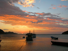 Sunset Taganga
 -
 Sunset
 -
 Sunset


Diving[edit]

Isla Agujais highlighted


Taganga is the starting point for one of the main dive locations of Colombia. TheMalpeloandGorgona Islandreserves are thePacificdive sites of the country, while diving aroundSan Andrés y Providencia,theRosario and San Bernardo Corals National Natural Parkoff the coast ofCartagenaand in Tayrona Park is done in the Caribbean. More than ten dive centers offer courses of all levels at low cost in Taganga. The prices are among the lowest of the Caribbean, competing withPanamaandUtila,Honduras.[37]
Various types ofcorals,sponges,sea turtles,molluscs,crustaceansand over 129 species of fish have been identified in the waters around Taganga and Tayrona Park. Most of the diving is concentrated aroundIsla Aguja( "Needle Island" ).
Underwater fauna that can be encountered in the vicinity of Taganga are among others:
- Hippocampus reidi,cabillito de mar;slender seahorse[38]
- Hippocampus erectus,lined seahorse[38]
- Pterois volitans,pez león;red lionfish (invasive species, hunted)[38][39]
- Sphyraena barracuda,gran barracuda;great barracuda[38]
- Stegastes partitus;bicolor damselfish[40]
- Acanthurus bahianus;ocean surgeon[40]
- Chromis cyanea;blue chromis[40]
- Sparisoma aurofrenatum;redband parrotfish[40]
- Myripristis jacobus;blackbar soldierfish[40]
- Halichoeres garnoti;yellowhead wrasse[40]
- Haemulon flavolineatum;French grunt[40]
- Chaetodon sedentarius;reef butterflyfish[40]
- Abudefduf saxatilis;sergeant major[40]
- Acanthurus coeruleus;blue tang[40]
- Canthigaster rostrata;Caribbean sharp-nose puffer[40]
- Haemulon chrysargyreum;yellowstripe grunt[40]
- Mulloidichthys martinicus;yellow goatfish[40]
- Bodianus rufus;Spanish hogfish[40]
- Pseudupeneus maculatus;spotted goatfish[40]
- Sparisoma viride;stoplight parrotfish[40]
- Thalassoma bifasciatum;bluehead wrasse[40]
- Synodus intermedius;sand diver[40]
- Ocyurus chrysurus;yellowtail snapper[40]
- Holocentrus adscensionis;squirrelfish[40]
- Pomacanthus arcuatus;gray angelfish[40]
- Clepticus parrae;Creole wrasse[40]
- Diodon holocanthus;longspined porcupinefish[40]
- Chaetodon ocellatus;spotfin butterflyfish[40]
- Microspathodon chrysurus;jewel damselfish[40]
- Serranus tabacarius;tobaccofish[40]
- Amblycirrhitus pinos;redspotted hawkfish[40]
- Prognathodes aculeatus;longsnout butterflyfish[40]
- Holocanthus ciliaris;queen angelfish[40]
- Scarus taeniopterus;princess parrotfish[40]
- Chaetodon striatus;banded butterflyfish[40]
- Scarus iseri;striped parrotfish[40]
- Lactophrys triqueter;smooth trunkfish[40]
- Cephalopholis cruentata;graysby[40]
- Chaetodon capistratus;foureye butterflyfish[40]
- Holacanthus tricolor;rock beauty[40]
- Pomacanthus paru;French angelfish[40]
- Haemulon plumierii;white grunt[40]
- Acanthostracion polygonius;honeycomb cowfish
- Gymnothorax moringa;spotted moray
-
 Diving around Isla Aguja
 -
 Diving around Isla Aguja
 -
 Coral around Isla Aguja
 -
 Coral around Isla Aguja
 -
 Lost diver statue


Gallery[edit]
-
 Church of Taganga
 -
 Church interior
 -
 View of Taganga, 2014
 -
 View of Taganga harbour from the north
 -
 Fishing boats in Taganga harbour


Panoramas[edit]


See also[edit]
References[edit]
- ^Google Maps Area Calculator
- ^abGoogle Maps Elevation Finder
- ^abc(in Spanish)History of Taganga
- ^Postal code Taganga
- ^abc(in Spanish)2015 -Etymology, droughts and park construction Taganga
- ^Caicedo & Guarín, 2011
- ^Sáenz Reyes, 2011
- ^Caicedo & Guarín, 2011, p.30
- ^Caicedo & Guarín, 2011, p.62
- ^Sáenz Reyes, 2011, pp.61-64
- ^Sáenz Reyes, 2011, p.95
- ^Sáenz Reyes, 2011, p.146
- ^Caicedo & Guarín, 2011, p.113
- ^Sáenz Reyes, 2011, p.73
- ^Sáenz Reyes, 2011, p.62
- ^Sáenz Reyes, 2011, p.72
- ^(in Spanish)2016 -Climate data Taganga February 2016
- ^Climate-data.org - Taganga
- ^abcd(in Spanish)2010 -The founder of Santa Marta-El Mundo
- ^Diccionario geográfico, 2010, p.412
- ^History of Colombia
- ^Exploration of Sierra Nevada de Santa Marta
- ^(in Spanish)Earthquake of May 22 1834
- ^(in Spanish)1998 -Taganga separate corregimiento again-El Tiempo
- ^(in Spanish)2015 -Taganga locality 2
- ^(in Spanish)2006 -Taganga, at risk?-Semana
- ^(in Spanish)2016 -Construction in Taganga
- ^(in Spanish)Cultural center Taganga
- ^How Israeli ex-soldiers turned a Colombia fishing town into a sex and drug den
- ^Cayó israelí que armaba orgías con drogas y menores en Taganga
- ^Sex, drugs and crime in Taganga: Colombia’s lesson on tourism development
- ^Israeli deported following arrest for running drug and sex hostel in Taganga
- ^Tras deportación del israelí Assi Moosh, habitantes de Taganga sienten más tranquilidad
- ^(in Spanish)2015 -Fishing activity in Taganga- El Tiempo
- ^Rodríguez Méndez et al., 2006, p.6
- ^(in Spanish)2014 -Taganga; a history of protests
- ^(in Spanish)2013 -Diving in Taganga- El Tiempo
- ^abcd(in Spanish)2010 -Underwater fauna Taganga
- ^(in Spanish)2010 -Lion fish hunt in Taganga
- ^abcdefghijklmnopqrstuvwxyzaaabacadaeafagahaiajakalCuadrado González, 2002, pp.49-57
Bibliography[edit]
- Caicedo Caballero, Karoll Lizbeth; Guarín Reyes, Erika Andrea (2011),Geología y petrología de las rocas metamórficas del sector comprendido entre las Bahías de Gaira y Taganga, Provincia tectónica de Santa Marta, Colombia - Geology and petrology of the metamorphic rocks of the sector between the Bays of Gaira and Taganga, tectonic province of Santa Marta, Colombia(in Spanish),Universidad Industrial de Santander,Bucaramanga,pp. 1–131
- Cuadrado González, Jeimy N. (2002),Caracterización de la estructura de las comunidades ícticas en las zonas arrecifales de Isla Aguja, Parque Nacional Natural Tayrona, Caribe Colombiano - Characterization of the ichtyofauna in the reef zones of Aguja Island, Tayrona National Park, Colombian Caribbean(PDF)(in Spanish),Universidad Javeriana,Bogotá,pp. 1–125,retrieved2016-07-08
- Rodríguez Méndez, Nataly; Gaitán, Saeko; Chaparro, Nicolás (2006),"Evaluación del crecimiento de juveniles del BagreAriopsis bonillaiutilizando alimento con probióticos en condiciones de laboratorio "[Evaluation of the growth of juvenile of CatfishAriopsis bonillaiusing food with probiotics in laboratory conditions](PDF),Revista AquaTIC(in Spanish),24:3–12,ISSN1578-4541,retrieved2016-07-08
- Sáenz Reyes, Julie Andrea (2011),Itinerario geológico de la franja costera entre el Aeropuerto Internacional Simón Bolívar y la Bahía de Taganga, Provincia geotectónica de Santa Marta - Geological itinerary of the coastal strip between the international airport Simón Bolívar and Taganga Bay, geotectonic province of Santa Marta(in Spanish), Universidad Industrial de Santander, Bucaramanga, pp. 1–282
- Various, authors (2010),Diccionario geográfico universal dedicado a la Reina Nuestra Señora - Universal geographic dictionary dedicated to Our Queen(in Spanish),Universidad Complutense,Madrid:Rev. José Torner, pp. 1–894,retrieved2016-07-08
External links[edit]
 Mediafrom Commons
 Travel informationfrom Wikivoyage
 Datafrom Wikidata
Recreational dive sites in Colombia | ||
|---|---|---|
| Caribbean coast |  | |
| Caribbean insular | ||
| Pacific | ||
| Andean | ||