
Tampin (town)
Tampin | |
|---|---|
Town anddistrict capital | |
| Other transcription(s) | |
| •Jawi | تمڤين |
| •Chinese | Đạm biên |
| •Tamil | தம்பின் |
 Downtown Tampin | |
 Location of Tampin in Negeri Sembilan | |
 Tampin Location of Tampin in Peninsular Malaysia | |
| Coordinates:2°29′23″N102°14′15″E/ 2.48972°N 102.23750°E | |
| Country | |
| State | |
| District | Tampin |
| Luak | |
| Established | 1840 |
| Government | |
| • Tunku Besar Tampin | Tunku SyedRazman al-Qadri |
| • President | Roduan Bin Ujang[1] |
| •Member of Parliament | Mohd Isam Mohd Isa(BN) |
| Area | |
| • Total | 69.24 km2(50 sq mi) |
| Elevation | 79 m (259 ft) |
| Population (2010)[3] | |
| • Total | 57,506 |
| • Density | 830/km2(1,200/sq mi) |
| Time zone | UTC+8(MST) |
| Postcode | 73xxx |
| Website | Tampin District Council |
Tampinis a town inTampin District,Negeri Sembilan,Malaysia,which bordersPulau Sebangtown inAlor Gajah District,Malacca.It is situated at the southern tip of the longestmountain rangeinMalaysia,theTitiwangsa Mountains.[4][5][6][7][8]
Tampin is located around 60 km south of the state capital city ofSerembanand 30 km northwest ofMalacca City,Malacca.
Toponymy
[edit]Tampin gets its name from the container or pouch weaved from thepandanusfronds.The container was used to store condiments such as the sticky dessertkelamaiordodoland the shrimp pastebelacan.The Tampin Adat Territory, a specific subdivision within thedistrict of the same namethat also encompasses the town is also known asLuak Tampin,withluakbeing the local term for a territory, area or district.
History
[edit]Tampin | |
|---|---|
Semi-autonomousluak | |
| Adat Territory of Tampin Wilayah Adat Tampin ولايه عادت تمڤين | |
 The Tampin Adat Territory relative to otherluaksinNegeri Sembilan | |
| Country | Malaysia |
| State | Negeri Sembilan |
| Adatinstitution | Tunku Besar Tampin |
| Government | |
| •Tunku BesarTampin | Razman al-Qadri |
Tampin was originally part ofLuakof Rembau.After theNaning Warin 1832, Raja Ali declared himself the ruler ofSeri Menantiand his son-in-law, Syed Shaaban, as the ruler of Rembau. This enraged other rulers of Negeri Sembilan as they had no right to the posts. In 1834 acivil warensued, which resulted in Raja Ali and Syed Shaaban retreating to Tampin and the area fromMount Tampinto Bukit Putus being removed from Rembau.[9]The provinces of Repah, Keru, Tebong and Tampin Tengah formed the district known as Tampin. Syed Shaaban became the first ruler of Tampin and proclaimed himself the title Tunku Besar Tampin. The district is one of the originalconfederationof nine states collectively known as Negeri Sembilan, which literally mean "Nine States" inMalay.
On 11 March 1889, theGovernor of the Straits Settlements,Sir Cecil Smith,held a meeting with the rulers ofJelebu,Sungai Ujong,Rembau,Seri Menantiand Tampin. The purpose of this meeting was to combine the districts to better manage them under British rule. Tampin, Rembau and Seri Menanti agreed to the proposal and were united as the Seri Menanti Confederation. The newly formed confederation accepted Martin Lister as its firstBritish Resident.[10]
After theindependence of Malayain 1957, Negeri Sembilan and its districts started forming local administrative councils. Formerly known as the Tampin Town Board, the Tampin District Council was established on 1 July 1980, as a result of a restructure of the state via the Local Government Act of 1976.
Politics
[edit]Tampin is a parliamentary constituency in theDewan Rakyatof theMalaysian Parliament.The current Member of Parliament since the2022 Malaysian general electionisMohd Isam Mohd Isa,anUMNOmember underBarisan Nasional.[11]The previous Member of Parliament for Tampin between 2018 and 2022 isHasan Bahrom,[12][13]anAMANAHmember under thePakatan Harapancoalition.
In turn, Tampin provides 3 seats to theNegeri Sembilan State Legislative Assembly.
Transport
[edit]Tampin is well served by the Malaysian transport system. By car it is accessible by eitherNorth–South Expresswayusing the Simpang Ampat exit in neighbouring Malacca, or usingFederal Route 1which connects Tampin toSerembanandJohor Bahru.This town is also linked toAlor GajahandMalacca CityviaFederal Route 61.Tampin is also the southern end ofFederal Route 9which begins inKarakin the east coast state ofPahang.Motorists fromMalaccaare thus able to access theEast Coast Expresswayto get toKuantanorKuala Terengganuwhile bypassingKuala Lumpur.

In terms ofpublic transport,Tampin is served by theKTMB.In fact,Gemas,which is part of Tampin district, is themeeting pointof West Malaysia'seasternandwesternrailway lines. ThePulau Sebang/Tampin railway stationis inPulau Sebang,which is on the Malaccan side, about 1 kilometer from the town centre. Furthermore, sinceMalacca Citydoes not have a railway station, people living in Malacca normally have to travel to the station in order to get on a train. There was a track from Pulau Sebang toMalacca CitybeforeWorld War IIbut it was dismantled by theJapanese Imperial Armyduring the war for the construction of the infamous BurmeseDeath Railway.
Gallery
[edit]-
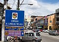 State border signboard between Tampin and Pulau Sebang (2008)
 -
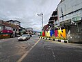 Downtown Tampin, seen from the Malaccan side
 -
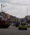 The state border (marked bytraffic lights) amidst a busy traffic, seen from the Negri side
 -
 State boundary line drawn on thepavement
 -
 Artistic Alley, downtown Tampin
 -
 Mural artdepicting local culture, Artistic Alley
 -


See also
[edit]References
[edit]- ^"Profil Yang DiPertua".12 August 2015.
- ^"Latar Belakang".19 October 2015.
- ^"TABURAN PENDUDUK MENGIKUT PBT & MUKIM 2010".Department of Statistics, Malaysia.Retrieved15 December2017.
- ^Yaakub Idrus.Rumah Melayu Negeri Sembilan: satu analisis seni bina Melayu.Penerbit Fajar Bakti, 1966, p. 11.https://malaycivilization.com.my/omeka/files/original/a884b36ae16d4af41735580e8b03038b.pdf
- ^https://www.researchgate.net/publication/273695651[bare URL]
- ^"Himalaya Sports TransNaning Ultra Challenge 2022".
- ^"Gunung Tampin".AllTrails.com.Retrieved2024-05-10.
- ^"Places of Interest".19 October 2015.
- ^"YDP Profile".Majlis Daerah Tampin.Retrieved18 September2009.
- ^Azilawani (14 April 2009)."Penyatuan Rembau, Tampin, Sri Menanti".National Archives of Malaysia.Retrieved24 September2009.
- ^HAMZAH, NOR AINNA (2022-11-19)."[RASMI] BN rampas kembali Parlimen Tampin".Utusan Malaysia(in Malay).Retrieved2024-05-10.
- ^"Ahli Parlimen".Portal Rasmi Parlimen Malaysia.Retrieved15 January2016.
- ^http://pru14.spr.gov.my/#!/parliament/5/P.133[bare URL]
External links
[edit]Capital:Seremban,Royal town:Seri Menanti | |||||||||||
| Topics |
| ||||||||||
| Society | |||||||||||
| Administrative divisions |
| ||||||||||