Tanambogo
Tanambogo Island | |
|---|---|
 After bombardment, August 7, 1942 | |
| Coordinates:009°06′40″S160°11′05″E/ 9.11111°S 160.18472°E | |
| Country | Solomon Islands |
| Province | Central Province |
| Island group | Nggela Islandsgroup |
Tanambogois a small island in theCentral ProvinceofSolomon Islandsin theNggela Islandsgroup, which was also known as the Florida Islands under theBritish Solomon Islands Protectorateand during World War 2.
History[edit]
The first recorded sighting by Europeans was by the Spanish expedition ofÁlvaro de Mendañaon 16 April 1568. More precisely the sighting was due to a local voyage done by a small boat, in the accounts thebrigantineSantiago,commanded bymaestre de campoPedro Ortega Valenciaand havingHernán Gallegoas pilot.[1][2]
World War II[edit]
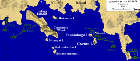
Along with the nearby island ofGavutu,it played an important role in theGuadalcanal campaignduringWorld War II.In 1942 theJapaneseattempted to establish aseaplanebase on the island. On 7–9 August 1942, in theBattle of Tulagi and Gavutu–Tanambogo,elements of theU.S. 2nd Marine Regimentassaulted and occupied the island.[3][4]
References[edit]
- ^Sharp, AndrewThe discovery of the Pacific IslandsOxford, 1960, p.45.
- ^Brand, Donald D.The Pacific Basin: A History of its Geographical ExplorationsThe American Geographical Society, New York, 1967, p.133.
- ^"Conquest of Tanambogo & Gavutu Islands".Retrieved25 October2012.
- ^"Second Marine Division".Retrieved24 October2012.


