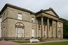
Tatton, Cheshire
Appearance
| Tatton | |
|---|---|
 | |
Location withinCheshire | |
| Population | 35 (2001) |
| OS grid reference | SJ752809 |
| Civil parish | |
| Unitary authority | |
| Ceremonial county | |
| Region | |
| Country | England |
| Sovereign state | United Kingdom |
| Post town | KNUTSFORD |
| Postcode district | WA16 |
| Dialling code | 01625 |
| Police | Cheshire |
| Fire | Cheshire |
| Ambulance | North West |
| UK Parliament | |
Tattonis a formercivil parish,now in the parish ofMillington and Rostherne,[1]in theCheshire Eastdistrict andceremonial countyofCheshirein England. It lay to the north ofKnutsfordand mostly coveredTatton Park.At the 2001 census, it had a population of 35.[2]The parish did not have a parish council.[3]
History
[edit]Tatton was formerly atownshipin the parish ofRostherne,[4]from 1866 Tatton was a civil parish in its own right,[5]on 1 April 2023 the parish was abolished to form "Millington and Rostherne".[6]
See also
[edit]References
[edit]Wikimedia Commons has media related toTatton, Cheshire.
- ^"Millington and Rostherne".Mapit.Retrieved17 July2023.
- ^Office for National Statistics:Census 2001: Parish Headcounts: MacclesfieldRetrieved 2009-12-04
- ^"Parish Meetings".www.cheshireeast.gov.uk.Retrieved13 January2018.
- ^"History of Tatton, in Macclesfield and Cheshire".A Vision of Britain through Time.Retrieved17 July2023.
- ^"Relationships and changes Tatton Tn/CP through time".A Vision of Britain through Time.Retrieved17 July2023.
- ^"Cheshire East Registration District".UKBMD.Retrieved11 October2023.

