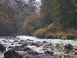
Triglav Bistrica
Appearance
| Triglav Bistrica | |
|---|---|
 Mist on the Triglav Bistrica | |
| Location | |
| Country | Slovenia |
| Physical characteristics | |
| Source | |
| • location | Below the north face of MountTriglav,Julian Alps |
| • coordinates | 46°24′42″N13°50′47″E/ 46.41167°N 13.84639°E |
| Mouth | |
• location | Sava Dolinka,nearMojstrana |
• coordinates | 46°27′45″N13°56′40″E/ 46.46250°N 13.94444°E |
| Length | 10 km (6.2 mi) |
| Basin features | |
| Progression | Sava→Danube→Black Sea |
TheTriglav Bistrica(Slovene:Triglavska Bistrica,also simply known as theBistrica)[1]is a stream that flows through the glacial Vrata Valley southwest ofMojstrana,Slovenia.Its source is below the north face of MountTriglavin the blind Bukovlje Valley, and it flows past theAljaž Lodge.[2]In addition to several intermittent tributaries with a flashy character, it also has three constant tributaries, all of them flowing from valleys below the east slope of MountŠkrlatica:Dry Creek (Suhi potok), Red Creek (Rdeči potok), and Peričnik Creek. The Triglav Bistrica empties into theSava Dolinkaat Mojstrana. It falls 400 meters (1,300 ft) during its approximately 10-kilometer (6.2 mi) course.
References
[edit]- ^Mauro Hrvatin; Matija Zorn (2018). "Recentne spremembe rečnih pretokov in pretočnih režimov v Julijskih alpah". In Zorn, Matija; Mikša, Peter; Lačen Benedičič, Irena; Ogrin, Matej; Kunstelj, Ana Marija (eds.).Triglav 240.Ljubljana: ZRC SAZU. p. 124.
- ^Carey, Justi; Clark, Roy (2019).The Slovene Mountain Trail: Slovenska planinska pot.Kendal, UK: Cicerone. p. 122.
External links
[edit] Media related toTriglav Bistricaat Wikimedia Commons
- The Triglav Bistricaon Geopedia

