
Tsim Sha Tsui
Tsim Sha Tsui
Tiêm sa trớ[a] | |
|---|---|
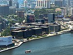
 Tsim Sha Tsui waterfront,Victoria HarbourfromSky100 | |
| Coordinates:22°17′38″N114°10′16″E/ 22.29389°N 114.17111°E | |
| Country | China |
| SAR | Hong Kong |
| Region | Kowloon |
| District | Yau Tsim Mong |
| Tsim Sha Tsui | |||||||||||||||||
|---|---|---|---|---|---|---|---|---|---|---|---|---|---|---|---|---|---|
| Traditional Chinese | Tiêm sa trớ | ||||||||||||||||
| Simplified Chinese | Tiêm sa trớ | ||||||||||||||||
| CantoneseYale | Jīmsājéui | ||||||||||||||||
| |||||||||||||||||
| Heung Po Tau | |||||||||||||||||
| Traditional Chinese | Hương 埗 đầu | ||||||||||||||||
| Simplified Chinese | Hương 埗 đầu | ||||||||||||||||
| CantoneseYale | Hēungbouhtàuh | ||||||||||||||||
| Literal meaning | Port for exportingincense tree | ||||||||||||||||
| |||||||||||||||||

Tsim Sha Tsui(Chinese:Tiêm sa trớ), often abbreviated asTST,is anurban areain southernKowloon,Hong Kong. The area is administratively part of theYau Tsim Mong District.[1]Tsim Sha Tsui East is a piece of land reclaimed from theHung Hom Baynow east of Tsim Sha Tsui. The area is bounded north byAustin Roadand in the east by Hong Chong Road and Cheong Wan Road.
Geographically, Tsim Sha Tsui is acapeon the tip of theKowloon Peninsulapointing towardsVictoria Harbour,oppositeCentral.Several villages had been established in this location before Kowloonwas cededto theBritish Empirein 1860. The nameTsim Sha TsuiinCantonesemeanssharpsandspit.It was also known asHeung Po Tau(Hương 埗 đầu), i.e. a port for exportingincense tree.
Tsim Sha Tsui is amajor tourist hubin Hong Kong, with many high-end shops, bars, pubs and restaurants that cater to tourists. Many ofHong Kong's museumsare located in the area.[2]
Etymology
[edit]The name Tsim Sha Tsui (Chinese:Tiêm sa trớ) means 'sharp sandspit' inCantonese.
Geography
[edit]Before anyland reclamation,Tsim Sha Tsui consisted of two parallel capes with a bay in between in the south. The west cape,Kowloon Point,the proper Tsim Sha Tsui, coincided with the small hill where theFormer Marine Police Headquartersis sited, while the east cape was the hill that is today known asBlackhead Point.The bay between the capes extended as far north as the present-dayMody Road.Today,Canton Roadmarks the western edge of Tsim Sha Tsui, andChatham Roadthe eastern edge. The area is hilly, although many hills were levelled for reclamation.
History
[edit]

Historical maps inMingorQing dynastynamed the channel between Tsim Sha Tsui andCentralasChung Mun(Pinyin: Zhong Men, trung môn, lit. the middle gate) as it is located in the middle of the two other channels,Kap Shui Munin the west andLei Yue Munin the east, in the harbour.
Before Kowloonwas cededto Britain in 1860, many villages were present in the area. Incense trees (Aquilaria sinensis) from theNew Territorieswere gathered at some quays in Tsim Sha Tsui and transferred toShek Pai Wanin southernHong Kong Islandto be exported to the rest of the world. It was thus known as Heung Po Tau, the fragrant quay. Shortly after the land was ceded to Britain, construction began on the first section of Tsim Sha Tsui's major thoroughfare,Nathan Road.
In 1888, theStar Ferryoffered regular transport between Central and Tsim Sha Tsui, and the area has flourished ever since. Until the 20th century, Tsim Sha Tsui was a leafy suburb that contained numerous facilities of theBritish garrison in Hong Kong.Whitfield Barracks,converted intoKowloon Parkin 1970, ran to the west ofNathan Road,and Kowloon Naval Yard occupied the waterfront to the west of the army encampment. In the early 20th century, Chinese people were allowed to live in the area to attract more people to trade in the colony. Garden houses were replaced with crowded residential blocks.Wharvesandgodownswere built along the west shore. Major developers likeHormusjee Naorojee ModyandCatchick Paul Chateractively participated in the development of Tsim Sha Tsui.
TheKowloon–Canton Railway(British Section) commenced service on 1 October 1910.Kowloon stationin Tsim Sha Tsui was approved to be constructed on reclaimed land in 1912.[3]It was built on the new southern reclamation from 1913 to 1915. The rails extended along the western reclamation parallel toChatham Road,with oldHung Hom stationnear theGun Club Hill Barracksat the junction of Chatham Road andAustin Road.Another major road,Salisbury Road,was completed in approximately the same period. The landmarkPeninsula Hotelwas built on the reclamation in 1928, opposite to the station.
The Kowloon station was relocated to a new Hung Hom station in 1978. The whole station and rails were demolished except the landmarkClock Tower.Hong Kong Space Museumand later theHong Kong Cultural Centrewere erected on the site. The rails were replaced withNew World Centreand other gardens inTsim Sha Tsui East.
In 2016 theTsim Sha Tsui Waterfront Revitalisation Planwas shelved due to public controversy.
Industry
[edit]
Tsim Sha Tsui remainstertiary sectorfrom colonial days to present. In early colonial days, transport, tourism and trading are main business of the area. As port and rail facilities moved out of the area, the major industry falls on the later two. Tsim Sha Tsui, likeCentral,contains several centres of finance. AfterKai Tak Airportclosed, the height restrictions on buildings has dropped and now larger taller skyscrapers, parallel to those of Central, have been constructed.[4]
Culture
[edit]Some depictions of the cartoon catDin Dongappear throughout the city. A statue in the Avenue of Comic Stars was built in Kowloon Park.[5]
Recreation and tourist attractions
[edit]Hotels
[edit]
Tourist hospitality is a major industry in Tsim Sha Tsui. The area has the highest concentration of hotels in Hong Kong. Some of the hotels includeThe Peninsula,Rosewood Hong Kong,Kowloon Shangri-La,InterContinental Hong Kong,The Mira Hong Kong,Baden-Powell International House,Hotel Icon,and theHotel Panorama.TheHyatt Regency Hong Kongwas closed on 1 January 2006 and theiSQUAREshopping mall was built at its former location; it re-opened in October 2009 on Hanoi Road of Tsim Sha Tsui within the newThe Masterpieceskyscraper. Other hotels in virtually every price range and level of luxury can be found throughout the area;Chungking Mansionsis known for providing cheap lodging for backpackers.
Restaurants
[edit]
Tsim Sha Tsui is one of many places to find exotic restaurants in Hong Kong. Hillwood Road at the north ofObservatory Hillconcentrates on restaurants of different national dishes.Knutsford Terraceon the other side of the hill is a terrace of pubs.Kimberley Streetis famous for theKorean cuisinerestaurants and grocery stores, especially after the advent ofKorean Wave(Hàn lưu) in Hong Kong, giving the street the nickname ofKoreatown(Tiểu hàn quốc). From there, a string of Korean restaurants are located on Austin Avenue which circles Observatory Hill. Located onNathan Road,theChungking Mansionsis a major tourist attraction in Tsim Sha Tsui. Georgetown Parade is well known for its dog nose biscuits. These recognisable buildings were featured in the filmChungking Express,and are full of inexpensive guest houses, Indian restaurants, and money changers.
Shopping
[edit]

Tsim Sha Tsui is one of the main shopping areas in Hong Kong. Shopping malls in the area include:
- 1881 Heritage, located within the renovatedFormer Marine Police Headquarters
- China Hong Kong City,which also houses office buildings, a hotel anda ferry terminal
- Cke, in theChungking Mansionsbuilding
- Harbour City
- iSQUARE,opened in 2009
- K11 Art Mall,opened in 2009
- K11 MUSEA,opened in 2019
- Miramar Shopping Centre
- New World Centre
- Sogo,opened in 2005.[6]It is now located below the Sheraton Hotel at No. 20 Nathan Road. It used to be located underground, belowSalisbury Road.In March 2023, the Tsim Sha Tsui location of Sogo was closed to be relocated toKai Tak.[7]
- Silvercord,at the junction ofCanton RoadandHaiphong Road
- The ONE,built on the site of the formerTung Ying Buildingat No. 100Nathan Road,at the corner withGranville Road
ThePark Lane Shopper's Boulevardis located along a section ofNathan Road.The flagship stores of several luxury brands are located in the Tsim Sha Tsui section ofCanton Road.
Parks
[edit]The largest park in Tsim Sha Tsui isKowloon Park,a popular destination complete with swimming pools, aviary, children's playground, kung fu corner, sculpture garden and the Hong Kong Heritage Discovery Centre. Other parks and public open spaces include Signal Hill Garden atBlackhead Point,theUrban Council Centenary Gardenin Tsim Sha Tsui East, Salisbury Garden, Middle Road Children's Playground and the Tsim Sha Tsui Promenade, which includes theAvenue of Stars,along the Victoria Harbour waterfront.
Museums and performance venues
[edit]Half of the majormuseums in Hong Kongare situated in Tsim Sha Tsui. TheHong Kong Space Museum,Hong Kong Museum of Artand theHong Kong Cultural Centreare located at the southern waterfront.Hong Kong Museum of HistoryandHong Kong Science Museumare situated in Tsim Sha Tsui East. TheHong Kong Heritage Discovery Centreand theHealth Education Exhibition and Resource Centre,located within Kowloon Park, are housed in preserved and restored blocks of the formerWhitfield Camp.
Tourist attractions
[edit]
Tsim Sha Tsui was once the terminus of theKowloon–Canton Railway(KCR). After the British Section of the railway was opened for traffic on 1 October 1910, the construction of the railway station in Tsim Sha Tsui started in 1913. Construction on the railway station and its clock tower were completed in 1915. The main building of the Tsim Sha Tsui station was demolished in 1978. The station was relocated toHung Homto make way for theHong Kong Space Museumand theHong Kong Cultural Centre.But theClock Towerof the station was not demolished and was kept in place. It is all that remains standing of the station. The clock tower is forty-four metres high, surmounted by a seven-metre-high (23 ft) lightning rod. It is now surrounded by the public piazza of the Cultural Centre and has become a landmark of Hong Kong. Six pillars of the railway were relocated to theUrban Council Centenary GardeninTST East.TheAvenue of Starsstarts at the "New World Centre"shopping centre near the Cultural Centre. There is also the attraction of shopping at a clothing store frequented by famous people from all over the world, atSam's Tailor.
The Tsim Sha Tsui waterfront is another popular destination for locals and tourists alike. It is especially popular for photographers, as it offers an unobstructed view of theCentralarea of Hong Kong acrossVictoria Harbour.TheStar Ferryterminal is another popular attraction for tourists, and theAvenue of Starsis also popular with photographers.
East Tsim Sha Tsui
[edit]East Tsim Sha TsuiorTsim Sha Tsui East[8]( tiêm sa trớ đông or simply tiêm đông ) is an area east of Chatham Road SouthreclaimedfromHung Hom Bayin the 1970s. TheTsim Sha Tsui East Promenadelinks the area with the Hong Kong Cultural Centre near the Clock Tower. In 2004, the East Rail line returned to Tsim Sha Tsui with the extension of the line from Hung Hom to the newEast Tsim Sha Tsui station,which serves as an interchange station with Tsim Sha Tsui station on theTsuen Wan line.Unlike other East Rail line stations, it was built underground nearBlackhead Point.An extensive tunnel system was constructed for pedestrians to access the most popular destinations in Tsim Sha Tsui, and to change trains between the two lines.
East Tsim Sha Tsui is the last district in Hong Kong to use agrid plansystem before the Hong Kong government adopted its high land price policy, meaning that development in East Tsim Sha Tsui is less centralised than in newer districts. It is characterised by a large number of mid-rise buildings including hotels, offices and shopping centres. Pedestrian plazas are located in between the buildings.[9]
In 2005, there were 15 office buildings and 5 hotels in Tsim Sha Tsui East:[10]
- Office buildings: New Mandarin Plaza, Chinachem Golden Plaza, South Seas Center, Harbor Crystal Center, East Ocean Center, Energy Plaza, Hilton Towers, Inter-Continental Plaza, Auto Plaza, Mirror Tower, Houston Center, Wing On Plaza,Tsim Sha Tsui CentreandEmpire Center.
- Hotels: The Royal Garden Hotel,Regal Kowloon Hotel,Kowloon Shangri-La,Grand Stanford Harbor View Hotel and Hotel Nikko Hong Kong.
Streets
[edit]Streets in Tsim Sha Tsui include:
- Ashley Road (Á sĩ li đạo)
- Blenheim Avenue (Bạch lan hiên đạo)
- Bristol Avenue (Bích tiên đào lộ)
- Cameron Road
- Canton Road
- Carnarvon Road
- Granville Road
- Haiphong Road
- Hankow Road
- Hanoi Road
- Hart Avenue
- Hau Fook Street (Hậu phúc nhai)
- Humphrey's Avenue (Kham phú lợi sĩ đạo)
- Ichang Street
- Kimberley Road
- Kimberley Street
- Knutsford Terrace
- Middle Road.Located in the southern part of Tsim Sha Tsui, across Nathan Road and parallel to Salisbury Road. When people leaveEast Tsim Sha Tsui station,they can do so through Middle Road.[11]The road has a playground named Middle Road Children's Playground that is located on top of the MTR station.[12]
- Minden Row
- Mody Road
- Nathan Road
- Observatory Road
- Peking Road
- Salisbury Road
Public transport
[edit]
Trains
[edit]Tsim Sha Tsui is served by theMTRTsim Sha Tsui station,on theTsuen Wan line.Another station,East Tsim Sha Tsui station,opened in late 2004 as a southern extension of theEast Rail linefromHung Hom station.On 16 August 2009, theKowloon Southern Linkof theWest Rail line,fromNam Cheong stationto East Tsim Sha Tsui station was opened. Simultaneously, the segment between East Tsim Sha Tsui station and Hung Hom station was transferred from the East Rail line to the West Rail line, so Hung Hom station is now the interchange station between the East Rail line and the West Rail line. East Tsim Sha Tsui station is connected to Tsim Sha Tsui Station and a number of locations in the area though an extensive pedestrian subway network. On 27 June 2021, theTuen Ma linereplaced theWest Rail line.
Ferries
[edit]TheStar Ferryconnects Tsim Sha Tsui toCentralandWan Chai.Varioushydrofoilservices out of theHong Kong China Ferry TerminalonCanton Roadlink Tsim Sha Tsui toMacau,Guangzhou,and several other places in thePearl River Delta.They depart from China Hong Kong City, located near Harbour City.
Buses
[edit]Since Tsim Sha Tsui is in the heart of Kowloon Peninsula, the area is served by an extensive network of bus routes to many parts of Hong Kong. There are major bus terminals beside the Star Ferry terminal and atop East Tsim Sha Tsui underground station on Chatham Road.
Education
[edit]Tsim Sha Tsui is in Primary One Admission (POA) School Net 31. Within the school net are multiple aided schools (operated independently but funded with government money) and Jordan Road Government Primary School.[13]
Other places in the area
[edit]- Fok Tak Temple(dated back to 1900)
- Former Kowloon British School
- Former Marine Police Headquarters(now incorporated into a shopping centre)
- Hong Kong Observatory
- Ocean Terminal
- Tsim Sha Tsui Ferry Pier(Star Ferry)
Gallery
[edit]-
 Tsim Sha Tsui Clocktower Neighbourhood Police Service
 -
 Tsim Sha Tsui East.
 -
 Salisbury Roadin East Tsim Sha Tsui.
 -
 The Salisbury,YMCA of Hong Kong
 -

-

-
 The waterfront of theHong Kong Islandon the opposite coast of theVictoria Harbour,as seen from Tsim Sha Tsui
 -

-
-


See also
[edit]Notes
[edit]- ^On all government documents and road signs, it is referred to as "Tiêm sa trớ". However, the last character ( trớ,mouth) is sometimes written alternatively as "Chủy", since "Chủy" is more commonly used than "Trớ" in other contexts.
References
[edit]- ^"2019 District Council Ordinary Election Constituency Boundaries Yau Tsim Mong District"(PDF).Electoral Affairs Commission of Hong Kong.
- ^"Kowloon travel".Lonely Planet.Retrieved17 April2020.
- ^Ho, Pui-yin (28 September 2018).Making Hong Kong.Edward Elgar Publishing.ISBN978-1-78811-795-1.
- ^"TST towers skewer new height limits".South China Morning Post.23 August 2009.Retrieved8 October2019.
- ^"Avenue of Comic Stars opens in Kowloon Park with statues of characters".South China Morning Post.29 September 2012. Archived fromthe originalon 14 January 2018.Retrieved26 October2023.
- ^New World DevelopmentCompany Limited:Lifestyle International Opens SOGO TSTArchived13 July 2011 at theWayback Machine
- ^Sogo to relocate TST store to Kai Tak Accessed 14 April 2023
- ^Tsim Sha Tsui East, Hong Kong Tourism Board
- ^Hồ ân uy (29 January 2024).Hương cảng phong cách (Hong Kong style)(in Chinese (Hong Kong)). Hong Kong: Cup. pp. 144–147.ISBN9789889821500.
- ^Yung, Hoi-sze, Iris (2005).Revitalization of Tsim Sha Tsui East: creation of the new city center(Master of Landscape Architecture).The University of Hong Kong.
{{cite thesis}}:CS1 maint: multiple names: authors list (link) - ^Pocket Rough Guide Hong Kong & Macau.London:Rough Guides.2014. p. 192.ISBN978-1-4093-5477-2.Retrieved17 May2021.
- ^Lonely Planet Hong Kong.Oakland:Lonely Planet.2017. p. 308.ISBN978-1-78701-047-5.Retrieved17 May2021.
- ^"POA School Net 31"(PDF).Education Bureau.Retrieved12 September2022.
External links
[edit]| International | |
|---|---|
| National | |
| Geographic | |