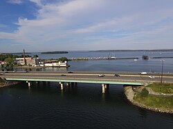
Tukey's Bridge
Appearance
Tukey's Bridge | |
|---|---|
 Tukey's Bridge from the west, above Back Cove | |
| Coordinates | 43°40′35″N70°15′23″W/ 43.6763°N 70.2565°W |
| Carries | Eight auto lanes; |
| Crosses | Back Cove |
| Locale | Portland,Maine |
| History | |
| Opened | 1960 |
| Location | |
 | |
Tukey's Bridgeis abridgeconnecting the neighborhoods ofMunjoy HillandEast DeeringinPortland,Maine.It is part ofInterstate 295,U.S. Route 1,andWashington Avenue(State Route 26).
Back Cove Trailcrosses the bridge on its western side.
History
[edit]Several bridges by the same name have existed connecting the areas.[1][2] The current bridge was completed in 1960 and named forLemuel Tukey,a tavern owner and tax collector from the Back Cove area of Portland in the late 18th century.[3]It replaced a bridge completed around 1898, and which carried thePortland and Yarmouth Electric Railway.[4]
Further reading
[edit]References
[edit]- ^History of Trains in PortlandArchived2011-06-11 at theWayback MachineUniversity of Southern Maine
- ^Back Cove Bridge: Tukey's BridgeArchived2012-07-13 atarchive.today
- ^I 295Interstate-guide.com
- ^Cummings, Osmond Richard (1957).Portland Railroad: Part I, historical development and operations.Connecticut Valley Chapter, National Railway Historical Society Inc. p. 16.
- "Tukey Bridge".Geographic Names Information System.United States Geological Survey,United States Department of the Interior.30 September 1980.Retrieved2010-11-03.
