
Urmond
Urmond | |
|---|---|
Village | |
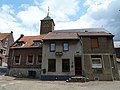
 Centre of Urmond | |
 Flag | |
 Urmond Location in the Netherlands  Urmond Location in the province of Limburg in the Netherlands | |
| Coordinates:50°59′26″N5°46′16″E/ 50.99056°N 5.77111°E | |
| Country | Netherlands |
| Province | Limburg |
| Municipality | Stein |
| Area | |
| • Total | 2.87 km2(1.11 sq mi) |
| Elevation | 46 m (151 ft) |
| Population (2021)[1] | |
| • Total | 3,555 |
| • Density | 1,200/km2(3,200/sq mi) |
| Time zone | UTC+1(CET) |
| • Summer (DST) | UTC+2(CEST) |
| Postal code | 6129[1] |
| Dialing code | 046 |
Urmondis a village in theDutchprovince ofLimburg.It is located in the municipality ofStein.
The village was first mentioned in 1153 as Ouermunte. The current name means "mouth of the Ur", however the Ur has later moved to village.[3]Urmond developed on the higher bank of theMaas.In 1400, it became part of theDuchy of Jülich.[4]
The Old St Martinus Church was built between 1791 and 1793. The medieval tower was placed in 1841. The cemetery is artificially heightened.[4]In 1695, a Dutch Reformed church was built in Urmond which is exceptional in Limburg.[5]
Urmond was home to 600 people in 1840.[5]Urmond was a separate municipality until 1982, when it was merged with Stein.[6]
Gallery
[edit]-
 Apartment buildings
 -
 Former town hall
 -
 Street view
 -
 Terp Church


References
[edit]- ^abc"Kerncijfers wijken en buurten 2021".Central Bureau of Statistics.Retrieved26 April2022.
two entries
- ^"Postcodetool for 6129AA".Actueel Hoogtebestand Nederland(in Dutch). Het Waterschapshuis.Retrieved26 April2022.
- ^"Urmond - (geografische naam)".Etymologiebank(in Dutch).Retrieved26 April2022.
- ^abSabine Broekhoven, & Ronald Stenvert (2003).Urmond(in Dutch). Zwolle: Waanders.ISBN90 400 9623 6.Retrieved26 April2022.
- ^ab"Urmond".Plaatsengids(in Dutch).Retrieved26 April2022.
- ^Ad van der Meer and Onno Boonstra,Repertorium van Nederlandse gemeenten,KNAW, 2011.
| Authority control databases:Geographic |
|---|
ThisDutch Limburglocation article is astub.You can help Wikipedia byexpanding it. |