
Urtijëi
Urtijëi | |
|---|---|
| Chemun de Urtijëi Comune di Ortisei Gemeinde St. Ulrich | |
 | |
Location of Urtijëi  | |
 Urtijëi Location of Urtijëi in Italy  Urtijëi Urtijëi (Trentino-Alto Adige/Südtirol) | |
| Coordinates:46°34′N11°40′E/ 46.567°N 11.667°E | |
| Country | Italy |
| Region | Trentino-Alto Adige/Südtirol |
| Province | South Tyrol(BZ) |
| Government | |
| • Mayor | Tobia Moroder[1] |
| Area | |
| • Total | 24.3 km2(9.4 sq mi) |
| Elevation | 1,230 m (4,040 ft) |
| Population (31 January 2015)[3] | |
| • Total | 4,753 |
| • Density | 200/km2(510/sq mi) |
| Demonym(s) | Italian:gardenesi ‹See Tfd›German:Sankt Ulricher |
| Time zone | UTC+1(CET) |
| • Summer (DST) | UTC+2(CEST) |
| Postal code | 39046 |
| Dialing code | 0471 |
| Patron saint | San Udalricus |
| Saint day | July 4 |
| Website | Official website |
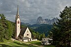
Urtijëi(Ladin:[uʀtiˈʒɜi̯];‹See Tfd›German:St. Ulrich in Gröden[zaŋktˈʊlrɪçɪnˈɡrøːdn̩];Italian:Ortisei[ortiˈzɛi]) is a town of 4,637 inhabitants inSouth Tyrolin northernItaly.It occupies theVal Gardenawithin theDolomites,a mountain chain that is part of theAlps.
Geography
[edit]Urtijëi borders the following municipalities:Kastelruth,Villnöß,LajenandSanta Cristina Gherdëina.
History
[edit]TheLadin-languagename Urtijëi derives from theLatinwordurticaand thesuffix-etum,with the meaning "place ofnettles".[4]
From 1860 to 1914, Urtijëi experienced a relevant economic growth due to the opening of a major road connecting Val Gardena to the main railroad; as a result the local woodcarving industry flourished. International tourism developed through the discovery of the Dolomites first by English tourists, and subsequently visitors from other parts ofAustria-Hungaryas well as theGerman Empire.Currently, the town'seconomyis mostly based on winterskiingtourism, summerhikingtourism, and woodcarving.
Coat of arms
[edit]The emblem showsSaint Ulrich,with the bishop's vestments and a gold cross in his right hand, mounted on a horse, with gold harness and a blue saddle pad, on three green mountains on a gold field. The emblem is decorated with a bluechief,with three small silver shields alternating with two golden bees; the bees symbolize the laboriousness of the inhabitants. The coat of arms was granted in 1907 and reappointed in 1970.
Blazon:Or,St Ulrich in bishops vestments with a crossOrin right hand, mounted on a white horseProperwith harness of the field and asaddle blanketAzureon atrimountVert;On achiefAzure,two beesOrbetween threeescutcheonsArgent.[5]
Main sights
[edit]- Parish Church of Urtijëi,made inneoclassical stylewithbaroqueelements in the last part of the 18th century.
- Church of St. Jacob, of ancient foundation, it was remodeled in styleLate-Gothicstyle during the 17th century. It preservesfrescoesfrom the second half of the 15th century and copies of the original baroque furnishings.
- Church of St. Antonius, built in the second half of the 17th century, it combines the simple Renaissance style structure with a predominantly baroque decorative structure.
- Church of St. Anna, located in the perimeter of the municipal cemetery, it is in Late-Gothic style. Inside it preserves baroque furnishings.
- Museum Gherdëina,the local heritage museum, which preserves geological, paleontological and archaeological finds found in the area, as well as a collection of wooden sculptures and toys.
- TheLuis TrenkerHouse of Culture, housed in a building designed by the architect Hubert Prachensky (1916–2009), preserves the ancient bell of the Magister Manfredinus.
- The bronze statue of theRoman legionary,sculpted in wood in 1904 byJohann Baptist Moroderand fused in bronze in 2001, in front at Villa Venezia.
- Villa Venezia, home and workshop of the sculptorJohann Baptist Moroder,constructed between 1902 and 1903 following thevenetian styleof architecture.
-
 Roman legionarysculpted in wood in 1904 byJohann Baptist Moroderand fused in bronze in 2001.
 -
 Church of St. Jacob
 -
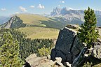 The pasture Resciesa


Society
[edit]According to the 2011 census, 84.19% of the population speaksLadin,9.30% German, and 6.51% Italian as first language.[6]
Notable people
[edit]
- Luis Trenker(1892–1990), film producer, director, writer, actor, architect, alpinist and bobsledder[7]
- Ernesto Prinoth(1923–1981), racing driver and founder ofPrinoth AG
- Isolde Kostner(born 1975), former Alpine skier, medallist at the1994and2002 Winter Olympics
- Carolina Kostner(born 1987), figure skater, lives in Urtijëi
- Moroder family
- Josef Moroder-Lusenberg(1846–1939), painter and sculptor
- Franz Moroder(1847–1920), politician and poet, the first mayor of Ortisei
- Johann Baptist Moroder(1870–1932), sculptor
- Rudolf Moroder-Lenèrt(1877–1914), sculptor specializing in religious art
- Ludwig Moroder(1879–1953), sculptor and teacher
- Friedrich (Rico) Moroder(1880–1937), sculptor
- Adele Moroder(1887–1966), author andLadin languagewriter
- Otto Moroder(1894–1977), sculptor
- David Moroder(1931–1997), luger and sculptor
- Giorgio Moroder(born 1940), singer, songwriter, DJ and record producer[8]
- Egon Rusina Moroder(born 1949), painter and illustrator, lives in Ortisei
References
[edit]- ^Ulrich, Gemeinde St."Tobia Moroder".St. Ulrich(in Austrian German).Retrieved2023-02-13.
- ^"Superficie di Comuni Province e Regioni italiane al 9 ottobre 2011".Italian National Institute of Statistics.Retrieved16 March2019.
- ^All demographics and other statistics from the Italian statistical institute (Istat)
- ^Kühebacher, Egon (1991),Die Ortsnamen Südtirols und ihre Geschichte. Die geschichtlich gewachsenen Namen der Gemeinden, Fraktionen und Weiler,vol. 1, Bolzano: Athesia, p. 502
- ^Heraldry of the World: Urtijëi
- ^"Volkszählung 2011/Censimento della popolazione 2011".Astat Info(38). Provincial Statistics Institute of the Autonomous Province of South Tyrol: 6–7. June 2012.Retrieved2012-06-14.
- ^IMDb Databaseretrieved 14 June 2019
- ^IMDb Databaseretrieved 14 June 2019
External links
[edit]![]() Media related toUrtijëiat Wikimedia Commons
Media related toUrtijëiat Wikimedia Commons
- Official website(in Italian)(Ladin)(in German)
- Museum Gherdëina - Local heritage museum

| International | |
|---|---|
| National | |
| Geographic | |