
Vilsandi
 Location of Vilsandi in Estonia. | |
| Geography | |
|---|---|
| Location | Baltic Sea(Atlantic Ocean) |
| Coordinates | 58°23′N2°51′E/ 58.383°N 2.850°E |
| Archipelago | West Estonian archipelago |
| Area | 9.4 km2(3.6 sq mi) |
| Highest elevation | 4.5 m (14.8 ft) |
| Administration | |
| Demographics | |
| Population | 22 (2017) |
The island ofVilsandiinSaaremaa ParishofEstonia'sSaare Countyis located in theBaltic Sea.It covers an area of some 9 square km and is the westernmost populated island in Estonia. The surrounding waters are shallow and rocky and many ships travelling the Baltic have perished nearby. The island of Vilsandi can be reached by boat, by truck having suitable clearance or on foot by wading fromSaaremaa.Much of the island is now part ofVilsandi National Park,which grew from a bird reserve founded in 1910. It is a highly sensitive ecosystem due to the use of the area by many migratory birds as a breeding and nesting ground. Hunting is absolutely prohibited. This park is a popular tourist destination not only for local Estonians, but also people ofFinlandwho are visiting Estonia in greater and greater numbers.
History[edit]
In 1703, a ship owned byDutchmanJohann Doll ran aground and sank in the Baltic Sea. Doll managed to get ashore to a nearby island and named the island “Felsland” meaning rocky island. He stayed to live there and, over time, Doll's farm became known in Estonian asTolli talu(farm) and Felsland became known asVilsandi.

Due to its location alongside a maritime trade route, it was important to seafaring nations that Vilsandi have some shelter for shipwreck survivors. This was especially important to theRussian Tsarand the first shelter on the island was built in 1806. This was followed by the construction of a 37-meter high lighthouse in 1809. A lifesaving station was built beside the lighthouse in 1859 and a telegraph line was installed in 1883, primarily to communicate news about ships running aground.[1]
The earliest known family settled on Vilsandi in 1826 and in 1896 this family took the surname of Mänder. Over time, as the letter “ä” was not familiar to the various non-Estonian seamen in the area, some family members changed Mänder to Mender because it was easier to spell. By 1860, 18 families lived on the island. In 1934 a census recorded that 32 families and 169 people lived on Vilsandi, sustained mainly by fishing (flounder, cod, salmon) and seafaring. The surrounding ocean is shallow with some depths to 22 metres (72 feet). In 1931 a seabird museum was built on Vilsandi and before World War II (1939–1945) there were about 200 permanent residents on the island and about 3,000 – 5,000 tourists that would visit during the summer months.
In 1870, the British shipAdmiralran aground near Vilsandi and many barrels of a new product, petroleum – the oil economy didn't exist yet – washed ashore and were used for fuel at Vilsandi's lighthouse and island homes, replacing firewood and flax oil.
Artur Toom(1884–1942) was appointed to manage Vilsandi's lighthouse in 1906 and he was instrumental in having the small Vaika islands just northwest of Vilsandi designated as a maritime bird reserve in 1910. The islands comprise a sensitive marine ecosystem used by a multitude of migratory birds as breeding and nesting grounds.[2]
World War I[edit]

During World War I, in October 1917, Germany launchedOperation Albion,a massive fleet of over 300 ships and 25,000 soldiers, to occupySaaremaaand other Baltic islands to try to force Russia, who governed Estonia at the time, to surrender. The invasion began at Vilsandi and was first noticed by Artur Toom, Vilsandi's lighthouse keeper.[3][4]In 1941, Toom was arrested by the Russians, accused of undertaking counterrevolutionary activities and spying for capitalist countries, and was sent to aStalinistwork camp where he perished in 1942.
One of Vilsandi's residents was Jaen Tear, a well-known seaman and shipbuilder, and the largest ship-owner on the island. He also managed the lifesaving station until his death in 1925. Jaen Tear's grandson, Jaan Elmar Teär, was born inKuressaareon 24 December 1930. In 1941, Jaan Teär's father and uncle, who were being held by the Russians at theBishop's Castlein Kuressaare, the capital of Saaremaa, were executed.
Vilsandi has produced 16 ship captains or Master Mariners, some of whom were related toPeeter All(1829–1898), a noted resident of the nearby island ofLoonalaid.Such captains include Peter Mender, Johann Kalmar, Siim Roos and Johannes Mänder. Kalmar, Mender and Roos worked in the Russian Far East and China prior to World War II and in 1930 co-founded the Estonian shipping firmMerilaid & Co.[5][6]
World War II[edit]
On 19 September 1944 about 40 of Vilsandi's 155 inhabitants escaped by boat to Sweden, evading a blockade by theKriegsmarine.Records show that 96 people escaped from Vilsandi in 1944, during the war, followed by one who escaped in 1956 and another in 1959, by which time only 46 inhabitants remained. Of the people who were able to flee the Russians, the majority settled in Sweden and others headed to Canada and the United States.
In 1945, after World War II had ended, the Soviet Union designated all of the islands around Vilsandi a restricted area closed to the public for national security reasons.
Today[edit]
Vilsandi became part of an Estonian national park in the early 1990s and today only a few people live there year-round. Many tourists visit in the summer months, some of which explore, by kayak, the approximately 100 small islands comprising the park. Tens of thousands of waterfowl migrate through or nest in the national park as do most of the Balticgrey seals.
Climate[edit]
Vilsandi has one of the mostmaritime climates(Cfb) in Estonia and thus it experiences generally cooler summers and milder winters than other parts of Estonia with smaller annual temperature range. Vilsandi is as well is usually the part of Estonia which receives the most hours of sunlight during a year with its weather station statistically the location with the most sunshine in Estonia.
| Climate data for Vilsandi (normals 1991–2020, extremes 1865–present) | |||||||||||||
|---|---|---|---|---|---|---|---|---|---|---|---|---|---|
| Month | Jan | Feb | Mar | Apr | May | Jun | Jul | Aug | Sep | Oct | Nov | Dec | Year |
| Record high °C (°F) | 8.1 (46.6) |
8.0 (46.4) |
15.9 (60.6) |
23.5 (74.3) |
28.7 (83.7) |
31.6 (88.9) |
32.1 (89.8) |
32.4 (90.3) |
27.9 (82.2) |
19.7 (67.5) |
13.1 (55.6) |
10.2 (50.4) |
32.4 (90.3) |
| Mean daily maximum °C (°F) | 1.3 (34.3) |
0.4 (32.7) |
2.6 (36.7) |
7.6 (45.7) |
12.9 (55.2) |
17.1 (62.8) |
20.8 (69.4) |
20.6 (69.1) |
16.1 (61.0) |
10.5 (50.9) |
6.0 (42.8) |
3.3 (37.9) |
9.9 (49.8) |
| Daily mean °C (°F) | −0.3 (31.5) |
−1.4 (29.5) |
0.6 (33.1) |
4.7 (40.5) |
9.7 (49.5) |
14.2 (57.6) |
17.8 (64.0) |
17.8 (64.0) |
13.9 (57.0) |
8.7 (47.7) |
4.5 (40.1) |
1.9 (35.4) |
7.7 (45.9) |
| Mean daily minimum °C (°F) | −2.2 (28.0) |
−3.3 (26.1) |
−1.4 (29.5) |
2.4 (36.3) |
7.0 (44.6) |
11.7 (53.1) |
15.4 (59.7) |
15.3 (59.5) |
11.7 (53.1) |
6.7 (44.1) |
2.8 (37.0) |
0.1 (32.2) |
5.5 (41.9) |
| Record low °C (°F) | −31.8 (−25.2) |
−28.1 (−18.6) |
−26.2 (−15.2) |
−13.6 (7.5) |
−3.1 (26.4) |
3.2 (37.8) |
7.1 (44.8) |
7.3 (45.1) |
0.4 (32.7) |
−6.4 (20.5) |
−10.8 (12.6) |
−28.6 (−19.5) |
−31.8 (−25.2) |
| Averageprecipitationmm (inches) | 44 (1.7) |
33 (1.3) |
33 (1.3) |
28 (1.1) |
31 (1.2) |
47 (1.9) |
49 (1.9) |
73 (2.9) |
59 (2.3) |
67 (2.6) |
63 (2.5) |
52 (2.0) |
577 (22.7) |
| Average precipitation days(≥ 1.0 mm) | 11 | 8 | 8 | 8 | 7 | 7 | 8 | 9 | 12 | 12 | 14 | 13 | 116 |
| Averagerelative humidity(%) | 86 | 86 | 83 | 81 | 80 | 82 | 81 | 80 | 81 | 82 | 86 | 86 | 83 |
| Mean monthlysunshine hours | 37.3 | 69.0 | 150.4 | 226.1 | 316.1 | 313.5 | 330.1 | 270.5 | 175.7 | 100.3 | 38.3 | 24.0 | 2,065.8 |
| Source:Estonian Weather Service(precipitation days 1971–2000)[7][8][9][10][11][12] | |||||||||||||
Notable residents[edit]
- Jaan Teär(1854-1925), ship owner and captain
- Artur Toom(1884-1942), Estonian ornithologist
- Jaan Tätte(born 1964), Estonian poet, actor, and singer
- Heino Väli(1928–1990), Estonian writer
Gallery[edit]
-
 A meadow on Vilsandi in summer
 -
 Vilsandi lighthouse
 -
 Sheep in Vilsandi
 -
 Vilsandi sea rescue station, wooden boathouse
 -
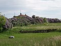
 Countryside on Vilsandi
 -
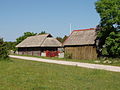
 Farmhouse on Vilsandi
 -
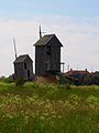 Windmills on Vilsandi
 -
 Vilsandi farmhouse
 -
 Vilsandi Station, rescue boat house in winter
 -
 Lilac hedge and stone wall on a Vilsandi farm


See also[edit]
References[edit]
- ^Armas, Luige, "Vilsandi tuletornist, päästejaamast, linnuriigist ja selle loojast.", Eesti LoodusISSN0131-5862,1980 No. 5, pp. 314–319.
- ^"Marine trips in Vilsandi archipelago".vilsandi.islander.ee.Archived fromthe originalon 2009-05-18.
- ^"OMM Featured Book: Operation Albion: The German Conquest of the Baltic Islands".onmilitarymatters.com.Retrieved6 April2018.
- ^"The forgotten fleet: the British navy and Baltic independence".baltictimes.com.Retrieved6 April2018.
- ^Mender, P., Thirty Years a Mariner in the Far East, The Memoirs of Peter Mender, a Standard Oil ship captain on China's Yangtze River,ISBN978-1-60910-498-6
- ^Võsari, Heljo Roos, A Captain's Daughter,ISBN978-0-80596-370-0
- ^ "Climate normals-Temperature".Estonian Weather Service.Retrieved30 January2021.
- ^ "Climate normals-Precipitation".Estonian Weather Service.Retrieved30 January2021.
- ^ "Climate normals-Humidity".Estonian Weather Service.Retrieved30 January2021.
- ^ "Climate normals-Sunshine".Estonian Weather Service.Retrieved30 January2021.
- ^ "Rekordid"(in Estonian). Estonian Weather Service.Retrieved7 April2021.
- ^ "Kliimanormid-Sademed, õhuniiskus"(in Estonian). Estonian Weather Service. Archived fromthe originalon 22 February 2012.Retrieved31 January2021.
External links[edit]
- Vilsandi – discussion forum for locals and visitors
- http://vana.www.sakala.ajaleht.ee/index.html?op=lugu&rubriik=85&id=6203&number=344
58°23′N21°52′E/ 58.383°N 21.867°E
| Town |  | |
|---|---|---|
| Small boroughs | ||
| Villages |
| |